Wichita, Kansas
Weather Forecast Office
|
A Second Winter Storm Impacts Kansas
|
|
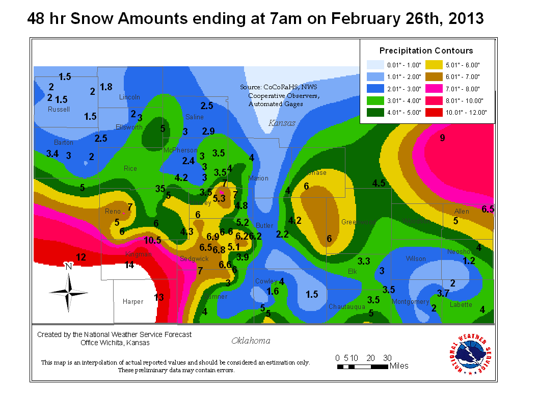
The second major winter storm in 5 days affected Kansas. Heavy snowfall rates and stronger north winds with this system resulted in periods of blizzard conditions across portions of south central and southwest Kansas. Snowfall exceeded one foot across Kingman and Harper counties with thundersnow being reported for the second time in less than a week. Wichita, Kansas recorded 6.8 inches of snowfall which was preceeded by 14.2 inches the previous week. This total of 21 inches set the all-time snowfall record for any month!
 |
 Radar animation from late morning through late evening, Feb. 25th, 2013 |
 Infrared satellite showing the cooler cloud tops and lightning data (thundersnow) across south central Kansas (Harper Co) on the evening of Feb. 25th, 2013. |
Pictures of the snow from February 25-26th, 2013
 Snow drift just north of Clearwater. Courtesy of Mick McGuire |
 Fun in the Wichita snow. Courtesy of Janet Spurgeon. |
|
 A snowy west Wichita. Courtesy of Kevin Darmofal |
 Courtesy of Janet Spurgeon |
|
 A picture of snow rollers. Courtesy of Andrew Watson in Clearwater, KS |
 Snow Rollers. Courtesy of Andrew Watson in Clearwater, KS |
|
|
West Wichita. Courtesy of Janet Spurgeon |
Snow pelted on fence and raingauge.Courtesy of Janet Spurgeon |
|
|
Trees covered in snow. Courtesy Janet Spurgeon |
|
|
|
Heavy Snow in Central Kansas. Photo courtesy Ken Cook |
Heavy Snow in Central Kansas. Photo courtesy Ken Cook |
|
|
Meteorologist Scott Smith out measuring snow on February 25th |
|
|
Hazards
Briefing pages
Local weather story
Submit a storm report
Storm Prediction Center
Enhanced Hazardous Weather Outlook
Current Conditions
Local Radar
National Radar
Satellite
Hourly weather(text)
Precip Analysis
Snowfall analysis
This day in weather history
7 Day Lightning Archive
Forecasts
Forecast Discussion
Weather Story
Fire Weather
Activity Planner
Aviation Weather
Soaring Forecast
Hurricane Center
Graphical Forecasts
Regional Weather Summary
Probabilistic Snow
Probabilistic QPF
Wet Bulb Globe temp
Climate
Local Climate Page
Daily/Monthly data(F6)
Daily Records
Climate Normals
Local drought page
Latest Climate Report(ICT)
Latest Climate Report(SLN)
Latest Climate Report(CNU)
CoCoRaHS
7 Day Lightning Archive
US Dept of Commerce
National Oceanic and Atmospheric Administration
National Weather Service
Wichita, Kansas
2142 S. Tyler Road
Wichita, KS 67209-3016
316-942-3102
Comments? Questions? Please Contact Us.


