Overview
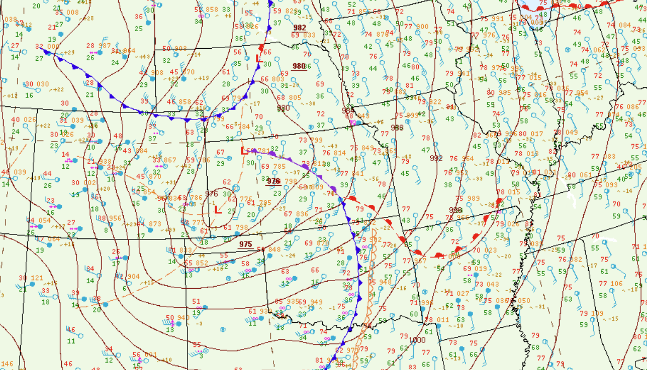
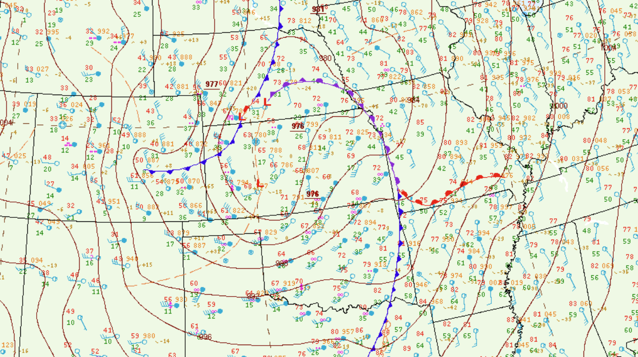
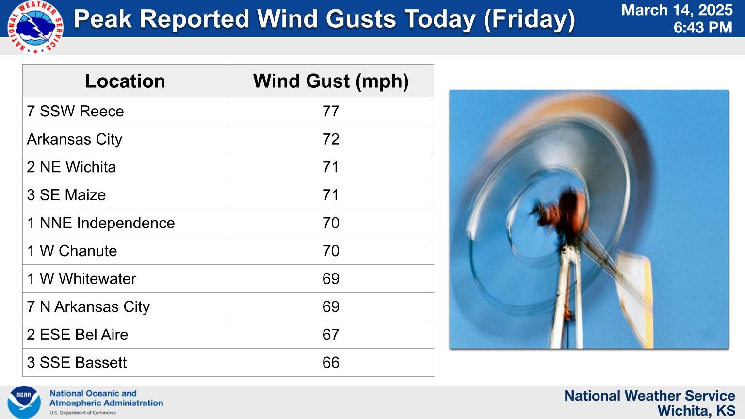
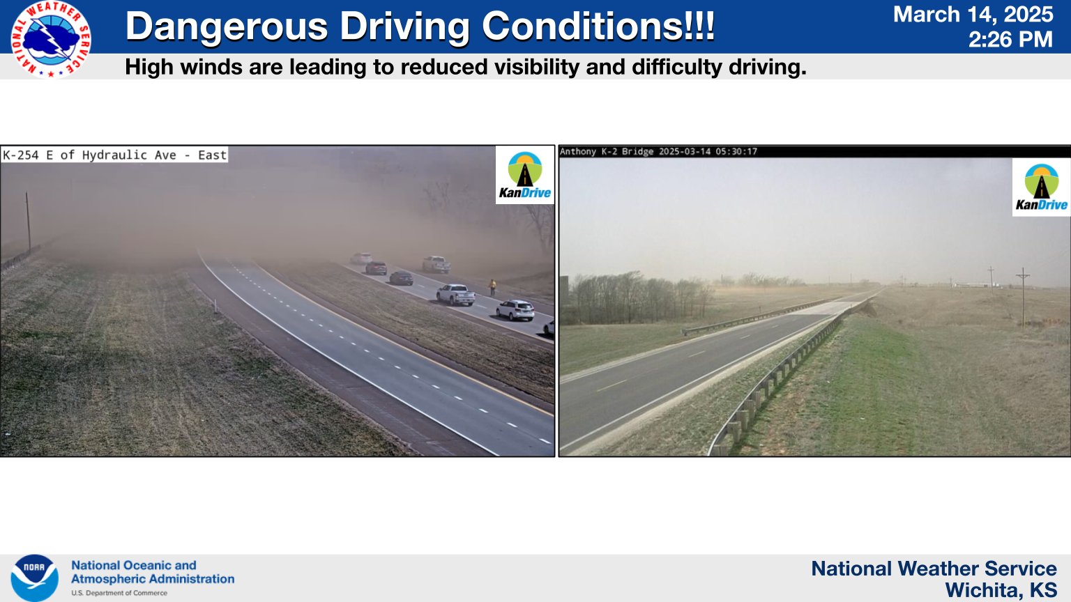
An intense low pressure system tracked out out the Rockies and into the Plains on Friday March 14th. This system produced 60 to 75 mph wind gusts across mainly south central and southeast Kansas that caused damage and also allowed numerous grass fires to get out of control. Strong winds also transported a significant amount of dust into the area which brought lower visibility due to blowing dust to much of southern Kansas.
Photos & Video
|
Water vapor satellite imagery |
 |
 |
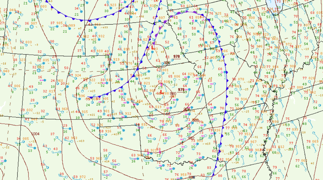 |
| March 14th 18z Surface map | March 14th 18z Surface map | March 14th 18z Surface map |
 |
 |
|
|
|
|
|
|
|
|
|
|
Storm Reports
Preliminary Local Storm Report...Summary
National Weather Service Wichita KS
842 PM CDT Fri Mar 14 2025

..TIME...   ...EVENT...      ...CITY LOCATION...     ...LAT.LON...
..DATE...   ....MAG....      ..COUNTY LOCATION..ST.. ...SOURCE....
            ..REMARKS..

0104 PM     Non-Tstm Wnd Gst 2 SE Viola              37.46N 97.62W
03/14/2025  M59 MPH          Sumner             KS   Mesonet

            Courtesy of KSU mesonet.

0115 PM     Non-Tstm Wnd Gst 1 SSE Wichita Eisenhowe 37.65N 97.43W
03/14/2025  M61 MPH          Sedgwick           KS   ASOS

            ASOS station KICT Wichita Eisenhower
            Airport.

0135 PM     Non-Tstm Wnd Gst Arkansas City           37.06N 97.04W
03/14/2025  M72 MPH          Cowley             KS   Public

            Home weather station.

0137 PM     Non-Tstm Wnd Gst 2 NE East Wichita       37.71N 97.23W
03/14/2025  M71 MPH          Sedgwick           KS   Broadcast Media


0139 PM     Non-Tstm Wnd Gst 7 N Arkansas City       37.17N 97.04W
03/14/2025  M68 MPH          Cowley             KS   ASOS

            REPORTED AT KWLD.

0150 PM     Non-Tstm Wnd Gst 3 ESE Bel Aire          37.75N 97.22W
03/14/2025  M67 MPH          Sedgwick           KS   ASOS

            Measured at Jabara Airport.

0151 PM     Non-Tstm Wnd Gst 7 SSW Reece             37.70N 96.49W
03/14/2025  M77 MPH          Greenwood          KS   Trained Spotter

            Measured with handheld anemometer in exposed
            area.

0152 PM     Non-Tstm Wnd Gst 3 E Hutchinson          38.06N 97.87W
03/14/2025  M64 MPH          Reno               KS   ASOS

            REPORTED AT KHUT.

0155 PM     Non-Tstm Wnd Gst 2 ENE East Wichita      37.69N 97.21W
03/14/2025  M58 MPH          Sedgwick           KS   AWOS

            REPORTED AT KBEC.

0155 PM     Non-Tstm Wnd Gst 2 WSW Mcpherson         38.36N 97.69W
03/14/2025  M61 MPH          McPherson          KS   Public

            REPORTED AT KMPR.

0156 PM     Non-Tstm Wnd Gst 4 ENE Newton            38.06N 97.28W
03/14/2025  M60 MPH          Harvey             KS   AWOS

            REPORTED AT KEWK.

0204 PM     Non-Tstm Wnd Gst 3 SW Salina             38.78N 97.65W
03/14/2025  M62 MPH          Saline             KS   ASOS

            Measured at the Salina Airport.

0204 PM     Non-Tstm Wnd Gst 1 W Whitewater          37.96N 97.17W
03/14/2025  M69 MPH          Harvey             KS   Trained Spotter


0206 PM     Non-Tstm Wnd Dmg 1 ESE Downtown Wichita  37.68N 97.32W
03/14/2025                   Sedgwick           KS   Emergency Mngr

            Many powerlines are reported down throughout
            the Wichita metro area.

0209 PM     Non-Tstm Wnd Dmg 4 W Marion              38.35N 97.09W
03/14/2025                   Marion             KS   Emergency Mngr

            Multiple vehicle roll-overs reported across
            the county.

0215 PM     Non-Tstm Wnd Gst 1 NNE Independence Airp 37.16N 95.78W
03/14/2025  M70 MPH          Montgomery         KS   AWOS

            REPORTED AT KIDP.

0222 PM     Non-Tstm Wnd Gst Arkansas City           37.06N 97.04W
03/14/2025  M59 MPH          Cowley             KS   Emergency Mngr

            Powerlines and large tree limbs were down
            around the city.

0224 PM     Non-Tstm Wnd Gst 8 WSW Piedmont          37.57N 96.49W
03/14/2025  M64 MPH          Elk                KS   Mesonet

            Courtesy of KSU mesonet.

0240 PM     Non-Tstm Wnd Gst 2 N Eureka              37.85N 96.29W
03/14/2025  M60 MPH          Greenwood          KS   AWOS

            Measured at K13K.

0248 PM     Non-Tstm Wnd Gst 3 SE Maize              37.74N 97.42W
03/14/2025  M71 MPH          Sedgwick           KS   Trained Spotter

            Measured near 29th and Ridge.

0252 PM     Non-Tstm Wnd Gst 1 W Chanute             37.67N 95.49W
03/14/2025  M69 MPH          Neosho             KS   Public

            REPORTED AT KCNU.

0252 PM     Non-Tstm Wnd Dmg 3 NW Hamilton           38.01N 96.20W
03/14/2025                   Greenwood          KS   Emergency Mngr

            Damage reported to outbuilding roofs and a
            grain bin.

0253 PM     Non-Tstm Wnd Gst 2 WSW Yates Center      37.86N 95.78W
03/14/2025  M61 MPH          Woodson            KS   Mesonet

            Courtesy of KSU mesonet.

0253 PM     Non-Tstm Wnd Dmg Eureka                  37.82N 96.29W
03/14/2025                   Greenwood          KS   Emergency Mngr

            Structural damage to a commercial building.

0255 PM     Non-Tstm Wnd Gst 3 SSE Bassett           37.87N 95.38W
03/14/2025  M66 MPH          Allen              KS   AWOS

            Allen County Airport.

0258 PM     Non-Tstm Wnd Gst 1 W Canton              38.38N 97.44W
03/14/2025  M63 MPH          McPherson          KS   Mesonet

            Union Pacific Railroad mesonet station.

0300 PM     Non-Tstm Wnd Dmg Augusta                 37.69N 96.97W
03/14/2025                   Butler             KS   Emergency Mngr

            Multiple reports of power lines down and/or
            leaning/damaged power poles across Butler
            county, including Rose Hill, Augusta, Leon,
            and El Dorado.

0300 PM     Non-Tstm Wnd Dmg El Dorado               37.82N 96.85W
03/14/2025                   Butler             KS   Fire Dept/Rescue

            Tree was blown down onto a house. Report
            relayed via Butler county EM. Time and
            location estimated.

0300 PM     Non-Tstm Wnd Dmg 9 WNW Piedmont          37.66N 96.53W
03/14/2025                   Butler             KS   Emergency Mngr

            Semi blown over near Beaumont on Highway
            400. Time and location estimated.

0302 PM     Non-Tstm Wnd Gst 3 SSE Bassett           37.87N 95.39W
03/14/2025  M66 MPH          Allen              KS   AWOS

            Measured at the Allen County Airport.

0311 PM     Non-Tstm Wnd Gst 6 W Elmdale             38.36N 96.75W
03/14/2025  M59 MPH          Chase              KS   Law Enforcement

            Relayed by Chase county EM. Occurred along
            Highway 150 at mile marker 11.

0315 PM     Non-Tstm Wnd Gst 1 W Chanute             37.67N 95.49W
03/14/2025  M70 MPH          Neosho             KS   ASOS

            REPORTED AT KCNU.

0315 PM     Non-Tstm Wnd Gst Independence Airport    37.16N 95.78W
03/14/2025  M59 MPH          Montgomery         KS   AWOS


0335 PM     Non-Tstm Wnd Gst Allen County Airport.   37.87N 95.39W
03/14/2025  M61 MPH          Allen              KS   AWOS


0347 PM     Non-Tstm Wnd Gst 7 N Arkansas City       37.17N 97.04W
03/14/2025  M69 MPH          Cowley             KS   ASOS

            Measured at Strother-Field Airport.

0356 PM     Non-Tstm Wnd Gst Parsons Tri-City Airpor 37.33N 95.50W
03/14/2025  M63 MPH          Labette            KS   ASOS


0410 PM     Non-Tstm Wnd Dmg Iola                    37.93N 95.40W
03/14/2025                   Allen              KS   Emergency Mngr

            Multiple reports of tree limbs down across
            town, along with a few utility poles. Much
            of Iola is out of power. Time estimated.

0446 PM     Non-Tstm Wnd Gst Coffeyville Airport     37.08N 95.57W
03/14/2025  M61 MPH          Montgomery         KS   ASOS


0448 PM     Non-Tstm Wnd Dmg 2 NW East Wichita       37.70N 97.28W
03/14/2025                   Sedgwick           KS   Public

            Public reported 3-inch tree limbs down as a
            result of strong wind gusts.

0506 PM     Non-Tstm Wnd Dmg 3 SW Andover            37.66N 97.17W
03/14/2025                   Sedgwick           KS   Broadcast Media

            Wood fencing blown down, and a power pole
            about half broken near Harry and 143rd
            Street East. Courtesy of KWCH mobile
            spotter.
 |
Media use of NWS Web News Stories is encouraged! Please acknowledge the NWS as the source of any news information accessed from this site. |
|


