|
An historic outbreak of tornadoes and severe thunderstorms impacted much of the Ohio Valley, Tennessee Valley and Mid-South during the afternoon and evening of February 5th (Super Tuesday) and during the overnight into the early morning hours of February 6th. As of February 10, there have been 59 fatalities reported--6 of which occurred in north Alabama--and 62 confirmed tornadoes, though storm surveys are still ongoing. This is the deadliest outbreak in the U.S. since May of 1985 when 76 were killed in Ohio and Pennsylvania. Unfortunately, this is not the first time violent (rating of F3 and greater) deadly tornadoes have struck the Tennessee Valley in February and during the nighttime hours. However, these were the first F-4 or EF-4 tornadoes to strike north Alabama in February (the only other February F-4 was in Moore and Franklin Counties in Tennessee in 1952).
A nearly ideal weather pattern for a severe weather outbreak took shape, and resembled what meteorologists look for when forecasting an event of this magnitude. Both "old school" and new tornado forecast parameters were all in agreement that a significant outbreak could occur.
 |
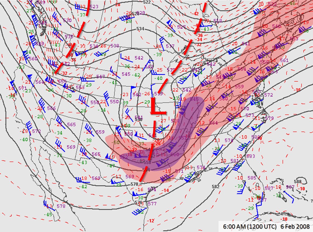
| The 500-millibar (roughly 15,000 feet elevation) map valid at 1200 UTC (6 AM CST) showed a potent area of low pressure centered near Kansas City, Missouri, and a potent area of faster winds extending from north Texas into Illinois around the base of the trough(click for a larger image). Base map courtesy the Storm Prediction Center. |
Aloft, a powerful upper level low pressure system moved out of the Rockies and into the central Plains. A strong upper level jet stream extended from the base of this trough in Texas through the Mississippi Valley and through the Great Lakes. Of note, a split in this jet stream over the middle South created upper level diffluence, an ingredient which helps to sustain long lived supercell thunderstorms. Upper level diffluence acts as a vaccuum, with air moving upward to compensate for the loss of air that is diverging in differing directions. As is typical with these types of storms, a low pressure system also formed at the surface, tracking east through Missouri into Illinois during the outbreak. A cold front extended south from the low through Arkansas and Louisiana during the afternoon. Ahead of the low, unseaonably warm and moist air was transported northward from the Gulf of America all the way north into the lower Ohio Valley. Temperatures reached the 60s and 70s in this zone, with dew points in the upper 50s to middle 60s. In fact, a few locations reached 80 degrees in the deep South. This is more typical of mid Spring during peak severe weather season rather than early February, and indeed, record high temperatures were set at both Huntsville and Muscle Shoals on February 5th. Unfortunately, temperatures dropped very little after sunset while dewpoints only increased, keeping an unseasonably warm and unstable air mass in place across the region overnight.
The three main ingredients for thunderstorms were all in place: moisture, a source of lift, and instability. For severe weather and tornadoes, an adequate combination of instability and wind shear are necessary. In the case of the Super Tuesday Outbreak, the combination was ideal for long lived supercells capable of long tracked strong tornadoes. These values were about as high as they get across the middle South for early February, with a "bullseye" centered in the vicinity of Memphis, Tennessee, during the afternoon when the outbreak began. As the evening evolved and the system moved further to the east, the area of significant severe weather parameters (shear and instability) shifted eastward into the lower Ohio and Tennessee Valleys. It was not until well after midnight that these parameters shifted into the northern Alabama and southern middle Tennessee.
 |
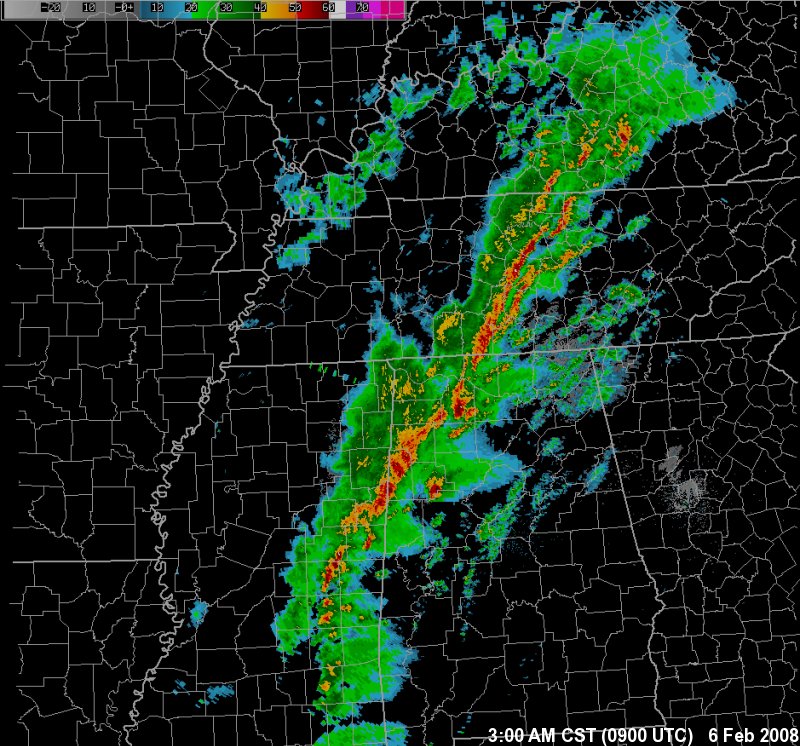
| A radar mosaic from 3 AM CST (0900 UTC), showing three main areas of concern: a broken squall line extending from central Mississippi northeastward into Kentucky; the first supercell thunderstorm producing a tornado in Lawrence County, and a second supercell thunderstorm producing a tornado in Fayette and Walker Counties. (This storm would later race into portions of northeast Alabama, producing EF-0 damage in Cullman County, EF-1 damage in Marshall County, and the tragic EF-4 damage in Jackson County.) |
Unfortunately, all of the elements came together at just the right time between 3:00 AM and 5:30 AM across north Alabama and southern middle Tennessee to produce several tornadoes, including the two long-track violent tornadoes that struck Lawrence and Morgan Counties and Jackson County. Those supercell thunderstorms had originated over central Mississippi and raced northeastward ahead of the cold front, producing tornadoes at several points along their journey across Mississippi and central Alabama. By the time they reached north Alabama, the supercells were at their strongest, producing the most violent tornadoes since the May 18, 1995 "Anderson Hills Tornado". The tornadoes may have fed off a ribbon of further-enhanced moisture and instability, and tornado development may have been aided by a pair of weak troughs of low pressure (one that advanced several miles ahead of the front, and another draped along the Alabama-Georgia state line which acted like a subtle warm front). Both storms permanently weakened once they moved into Tennessee and Georgia and did not produce further significant damage.
The rarity of such a devastating tornadic outbreak during the winter months should reinforce the importance of severe weather awareness and safety.
|


 Local Radar
 Weather Map