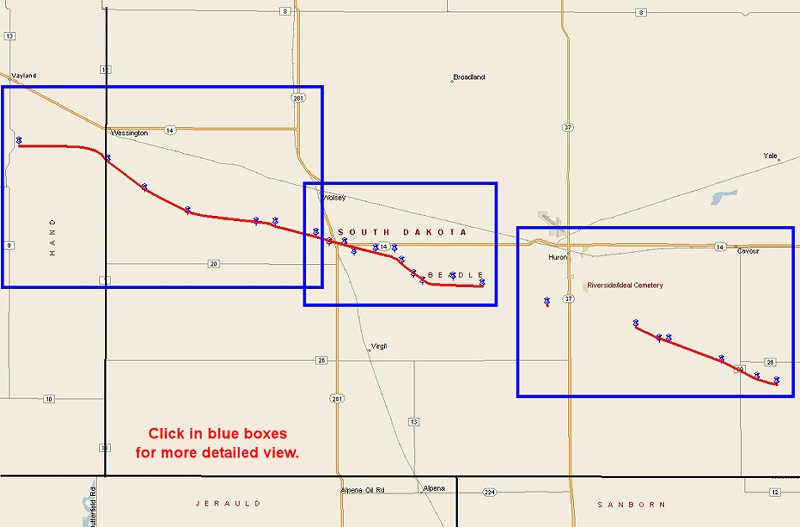
The first Beadle County tornado originally touched down in Hand County…about 5 miles west of Wessington. This tornado entered Beadle County at approximately 637 pm…just south of Wessington…doing F2 (113-157 mph) damage to a farmstead 2 miles southeast of Wessington. The aerial survey confirmed this to be a long track tornado of approximately 24.5 miles long…finally lifting 3.5 miles southwest of Huron at 718 pm. This tornado was on the ground for a total of 50 minutes…including the time on the ground in Hand County. Sporadic damage occurred along the path of the tornado…including more F2 damage to five large metal truss high voltage transmission towers 7 miles west-southwest of Wolsey. However…the tornado reached its peak intensity 2 miles south of Wolsey…where F3 (158-206 mph) damage occurred. Winds in this area were estimated to be around 200 mph…with the tornado 400 to 500 yards wide.
This tornado finally lifted southwest of Huron…but then the supercell thunderstorm began strengthening again as it continued east…passing about 1.5 miles south of Huron. The same severe thunderstorm went on to generate a second long track tornado of 7 miles…stretching from around 3 miles southeast of Huron to 10 miles southeast of Huron. This tornado was on the ground for approximately 22 minutes…from 718 pm to 740 pm…and at one point was around 300 yards wide…producing another swath of F2 storm damage seven miles south of Cavour.
While this second Beadle County tornado was on the ground…a third small rope tornado touched down 1.5 miles south-southwest of Huron at approximately 723 pm. The Kingsbury County tornado…producing little or no damage…touched down at approximately 756 pm and will be rated an F0.


 Weather Story
 Weather Map
 Local Radar