|
|
|
|
|
|
|
On the morning of July 11, 2011, a powerful long-lasting straight-line windstorm, known as a derecho, developed over central Iowa and carved a path of extensive damage across east central Iowa. The storm first took shape as a cluster of low end severe storms over southern Nebraska during the late afternoon of July 10. The system continued northeastward and entered western Iowa at 1:00am, still only as a marginal line of severe storms. As the system passed through the northern Des Moines metro area at 3:30am, it interacted with an outflow boundary from the storms to the north and rapidly intensified as it accelerated eastward. Over the next hour and a half the storm plowed eastward through Story, Marshall, and Tama Counties, blasting the area with winds of up to 105 mph, the equivalent of an EF1 tornado. The storm continued to track eastward, plowing through eastern Iowa and the southern Great Lakes region before dissipating in West Virginia in the mid-afternoon. Thousands of trees were downed in eastern Iowa alone and numerous structures were damaged or destroyed.
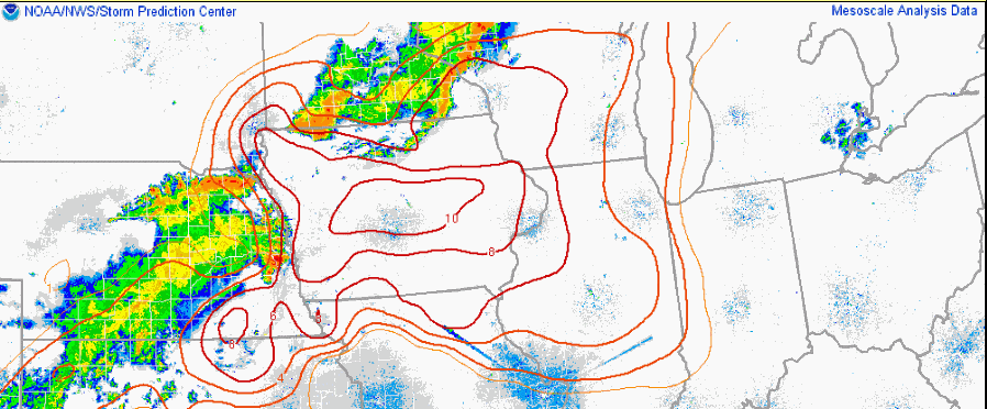
Derechos are able to last for several hours, and their gust fronts produce high end damage. In order for these storms to last so long, then need both instability and wind shear. Instability refers to the storm's ability to tap into the warm moist air near the surface as it develops. Meteorologists use the term CAPE (Convective Available Potential Energy) as a way to measure the amount of instability. Wind shear refers to how the wind changes at different heights above ground. Generally, severe weather is likely when the atmosphere has a combination of both high instability and high shear values. In this case, there was plenty of warm moist air at the surface. Temperatures as of 2:00am on July 11 were near 80F across Central Iowa, and dew points were in the mid 70s. This contributed to high CAPE values of 3000-4000 J/kg. At the same time, the wind shear in the lowest 3000 ft of the atmosphere was near 30 kts, which is considerably high.
 |
 |
 |
| Surface Obs and Radar over Iowa at 2:00am July 11 | MLCAPE values (Red Lines) over Iowa at 2:00am July 11 | 1km Shear Values over Iowa at 2:00am July 11 |
One quick and easy way to get an idea of the potential for a derecho event is by looking at the "Derecho Parameter". This parameter is calculated from both instability and wind shear, and it highlights the regions where they overlap. The derecho parameter was quite high that morning and was maximized just ahead of the advancing derecho as it moved from Iowa to Lake Michigan.
 |
| The Derecho Parameter and Radar Data from 1:00am to 7:00am July 11 |
Click an image below to view loops of the storm as it tracked through the Des Moines County Warning Area.
 |
 |
| Base Reflectivity Radar Loop from 3:09am to 4:55am | Base Velocity Radar Loop from 3:09am to 4:55am |
Velocity images from the Des Moines radar were particularly impressive during the course of this event.
 |
 |
 |
 |
 |
 |
 |
 |
 |
 |
 |
 |
An outflow boundary is a term used to describe the leading edge of the rain cooled air generated by a thunderstorm downdraft. Outflow boundaries can travel many miles out from a storm and persist long after a storm has dissipated. During the late evening hours of July 10, a storm over southern Minnesota developed an outflow boundary that propagated southward into Iowa. This outflow boundary began interacting with the northern end of what was a low end severe thunderstorm just north of Des Moines and likely aided in the system's rapid intensification and generation of the bookend vortex on the northern end of the storm. The white arrows in the images above denote the leading edge of the outflow boundary as it tracked south. The radar images were taken at 2:42am, 2:56am, and 3:18am.
 |
 |
 |
After the system passed through Marshalltown it became more organized and developed a circulation on the north end of the squall line known as a bookend vortex. The development of the bookend vortex coincided very well with the onset of higher end severe winds (100 mph and greater) as noted on the damage survey. The storm relative velocity image on the left was taken just after the development of the vortex and shows 91 kts (105 mph) of gate to gate shear in the yellow circle. The circulation extended throughout the depth of the storm, as illustrated by the four panel storm relative velocity image from the 0.5 to 1.8 degree scans (circulation shown by black circle). As the vortex tightened up it began to appear on the reflectivity imagery with the higher reflectivities being drawn into the circulation (right image, arrows denoting the path of the winds). The bookend vortex is also visible on the base reflectivity loop.
 |
 |
 |
As the storm tracked eastward, it developed a classic signature on reflectivity data known as a rear inflow notch. This notch, shown in the left image above (white arrow), appears as a weakening in the reflectivity field directly behind the bowing segment of the storm and is the result of another phenomena called a rear inflow jet. A rear inflow jet a mesoscale jet that transports air from the mid levels of the atmosphere to the front of the storm. This dry mid-level air evaporates the precipitation on the backside of the storm, creating the rear inflow notch. The middle image above is a four panel velocity image at the 0.5, 1.4, 3.2 and 5.1 degree radar scans. Note how the strongest winds in the derecho shift from the leading edge of the bow echo at 0.5 degrees near Garwin (beam height of 4300 ft AGL) to about 30 miles behind the storm east of Maxwell (beam height of 17,000 ft AGL). This is the rear inflow jet descending through the storm. The cross section on the right using storm relative velocity data also illustrates the rear inflow jet, with the black arrows tracing the path of the winds through the storm.
Below is a map of the areas affected by this storm in the Des Moines National Weather Service County Warning Area, with the different color contours denoting the strength of the winds. This map was developed using information from local storm reports received by the NWS, radar data, as well as the storm survey conducted after the event. The derecho continued into the Quad Cities' County Warning Area, hence the cutoff in the damage track on the east side of the map.
| Contour Legend | Black: General Severe Winds (58 mph+) | Yellow: Winds of 70mph + | Red: Winds of 100 mph + |

 |
 |
| Nationwide Storm Reports (through 7:00am 07/11/2011) | Nationwide Storm Reports (after 7:00am 07/11/2011) |
Photos taken during the NWS damage survey following the storm.
 |
 |
 |
 |
 |
 |
 |
 |
 |
 |
 |
 |
 |
 |
 |
Aerial and ground photos taken by Kip Ladage throughout Tama County.
 |
 |
 |
 |
 |
 |
 |
 |
 |
 |
 |
 |
 |
 |
 |
 |
 |
 |
...PRELIMINARY DAMAGE SURVEY RESULTS FOR STORY...MARSHALL AND TAMA COUNTIES...
THIS STORM SURVEY INVESTIGATION IS STILL ONGOING AND SUBJECT TO FURTHER COORDINATION WITH LOCAL EMERGENCY MANAGEMENT AGENCIES.
...WIDESPREAD AND EXTREME STRAIGHT LINE WIND EVENT...
THE FOLLOWING IS A PRELIMINARY ASSESSMENT FOR THE DAMAGE THAT OCCURRED OVER STORY...MARSHALL AND TAMA COUNTIES...OR FROM CENTRAL INTO EAST CENTRAL IOWA...EARLY IN THE MORNING ON MONDAY...JULY 11...2011.
EVENT DATE: 07/11/2011
ESTIMATED START TIME: APPROXIMATELY 320 AM CDT.
EVENT TYPE: DERECHO. NO TORNADOES WERE INDICATED DURING THIS EVENT. THIS PARTICULAR DERECHO BEGAN IN CENTRAL IOWA AND TRAVELED ACROSS CENTRAL AND EASTERN IOWA...AS WELL AS ACROSS ILLINOIS...LAKE MICHIGAN...MICHIGAN...AND ENDED IN ONTARIO CANADA. THIS DERECHO TRAVELED FROM CENTRAL IOWA TO DETROIT MICHIGAN...OR A DISTANCE OF APPROXIMATELY 550 MILES...OVER THE TIME SPAN OF NINE HOURS. A DERECHO IS A LONG LIVED...WIDESPREAD...DAMAGING WIND STORM WHICH IS ASSOCIATED WITH RAPIDLY MOVING SHOWERS AND THUNDERSTORMS. DERECHOES ARE OFTEN CURVED OR BOWED IN THEIR SHAPE. WINDS IN DERECHOES CAN EXCEED 100 MPH. THE WINDS ASSOCIATED WITH DERECHOES ARE NOT CONSTANT AND MAY VARY CONSIDERABLY ALONG THEIR PATHS.
EVENT LOCATION: BEGAN JUST WEST OF INTERSTATE 35 IN SOUTHERN STORY AND NORTHERN POLK COUNTIES. CONTINUED EASTWARD INTO MARSHALL AND TAMA COUNTIES.
PEAK WIND: THE HIGHEST WINDS WERE AT LEAST 80 TO 105 MPH.
PATH WIDTH: THE PATH WIDTH OF THE STRONGEST...HIGH-END WINDS WAS IN TAMA COUNTY AND WAS 5 MILES WIDE. IN ADDITION...THERE WAS A 10 MILE WIDE PATH OF WIND SPEEDS OF 70 TO 80 MPH. THERE WAS ALSO A 15 TO 20 MILE WIDE PATH OF WIND SPEEDS OF 60 MPH OR GREATER. IT SHOULD BE NOTED THAT THE DAMAGE SWATHS FROM THESE WINDS WERE NEARLY CONTINUOUS...AND EXTENDED FROM SOUTHERN STORY AND NORTHERN POLK COUNTIES...ACROSS MARSHALL AND TAMA COUNTIES.
PATH LENGTH: THE DAMAGE SWATHS FROM THESE WINDS WERE NEARLY CONTINUOUS...AND EXTENDED FROM SOUTHERN STORY AND NORTHERN POLK COUNTIES...ACROSS MARSHALL AND TAMA COUNTIES.
INJURIES: NONE HAVE BEEN REPORTED TO THE NATIONAL WEATHER SERVICE IN DES MOINES THUS FAR.
FATALITIES: NONE HAVE BEEN REPORTED TO THE NATIONAL WEATHER SERVICE IN DES MOINES THUS FAR.
DISCUSSION/DAMAGE: THIS WIND EVENT HAS BEEN THE MOST WIDESPREAD AND DAMAGING ONE TO AFFECT CENTRAL AND EAST CENTRAL IOWA SINCE 1998. AGAIN...NO TORNADOES WERE INDICATED. THE DAMAGE WAS DUE TO STRAIGHT LINE WINDS FROM A DERECHO. HAVING SAID THAT...THE STRONGEST WINDS DURING THIS EVENT WERE SIMILAR TO THOSE FOUND IN AN EF1 TORNADO. THE WIND DAMAGE FROM THIS EVENT WAS MORE WIDESPREAD THAN THE DAMAGE A TORNADO HOWEVER. EXAMPLES OF THE NOTABLE WIND SPEEDS FOLLOW AND HAVE BEEN ESTIMATED FROM OBSERVED DAMAGE. NEAR HUXLEY...96 MPH. MAXWELL...94 MPH. NEAR MARSHALLTOWN...70 TO 90 MPH. JUST EAST OF GARWIN...105 MPH. BETWEEN GARWIN AND UNION GROVE STATE PARK...85 TO 97 MPH. JUST SOUTH OF TRAER...100 MPH. JUST SOUTH AND SOUTHWEST OF DYSART...105 TO 110 MPH. SOUTH OF DYSART...80 TO 100 MPH.
More information on derechos can be found on the Storm Prediction Center's website.

