Overview
|
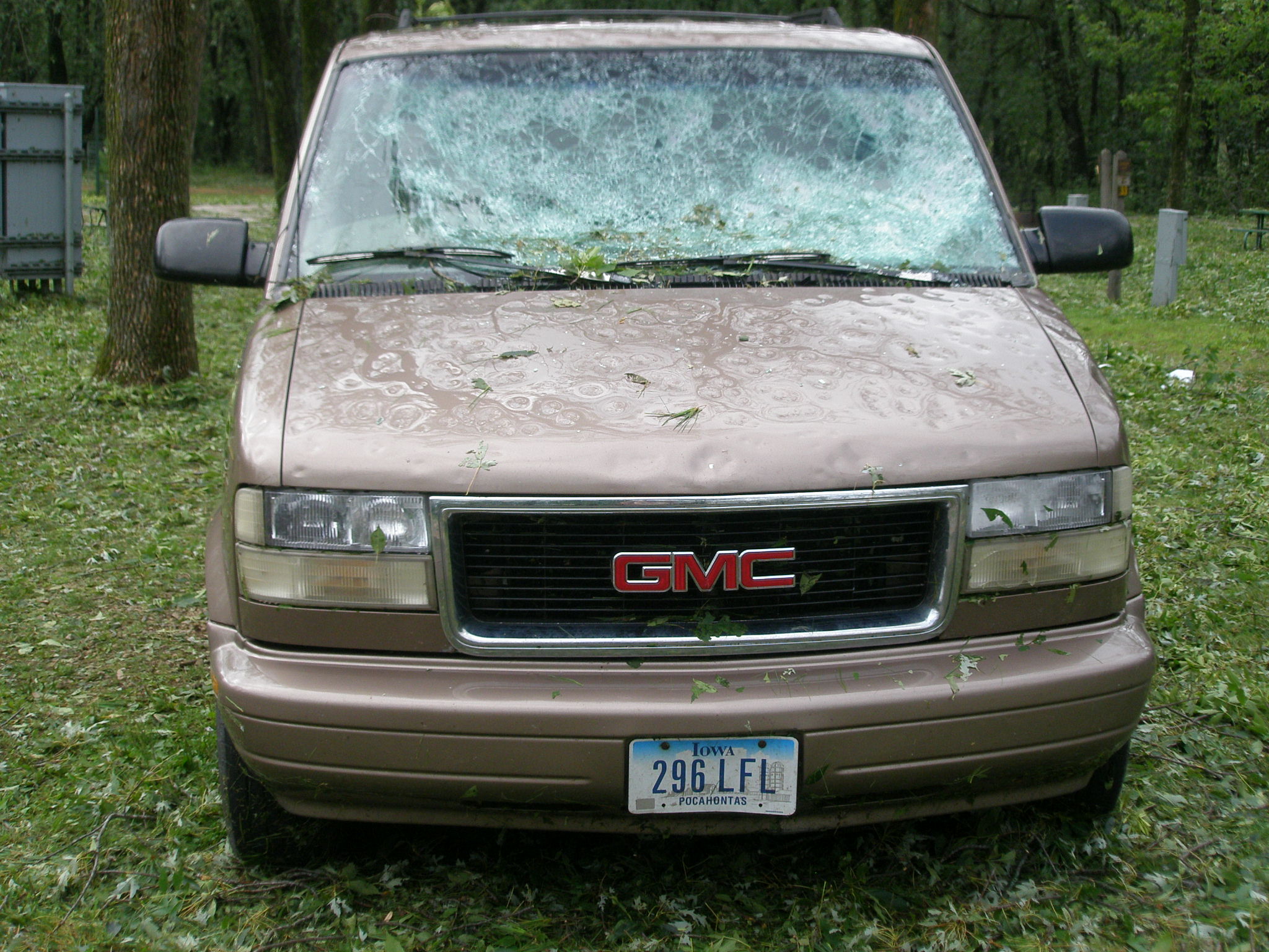
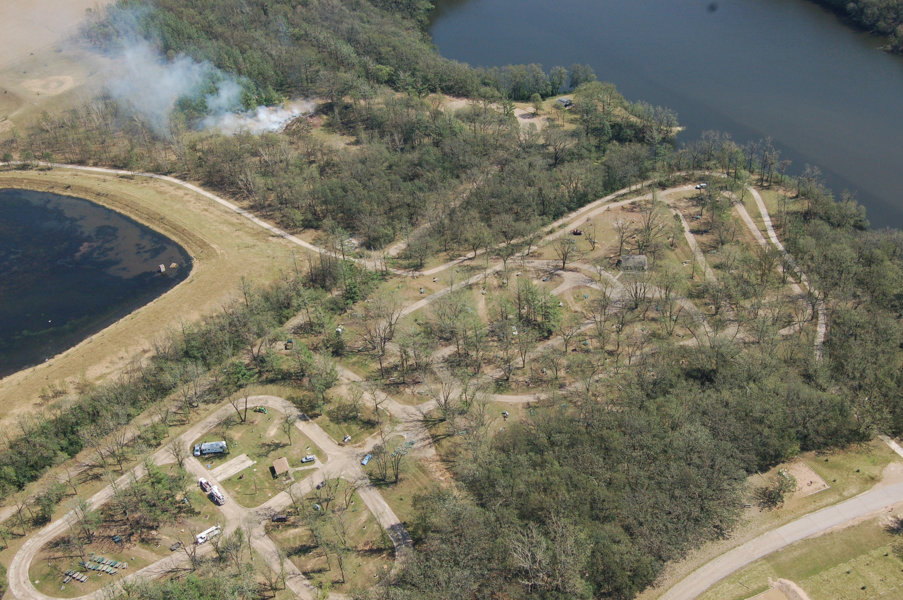
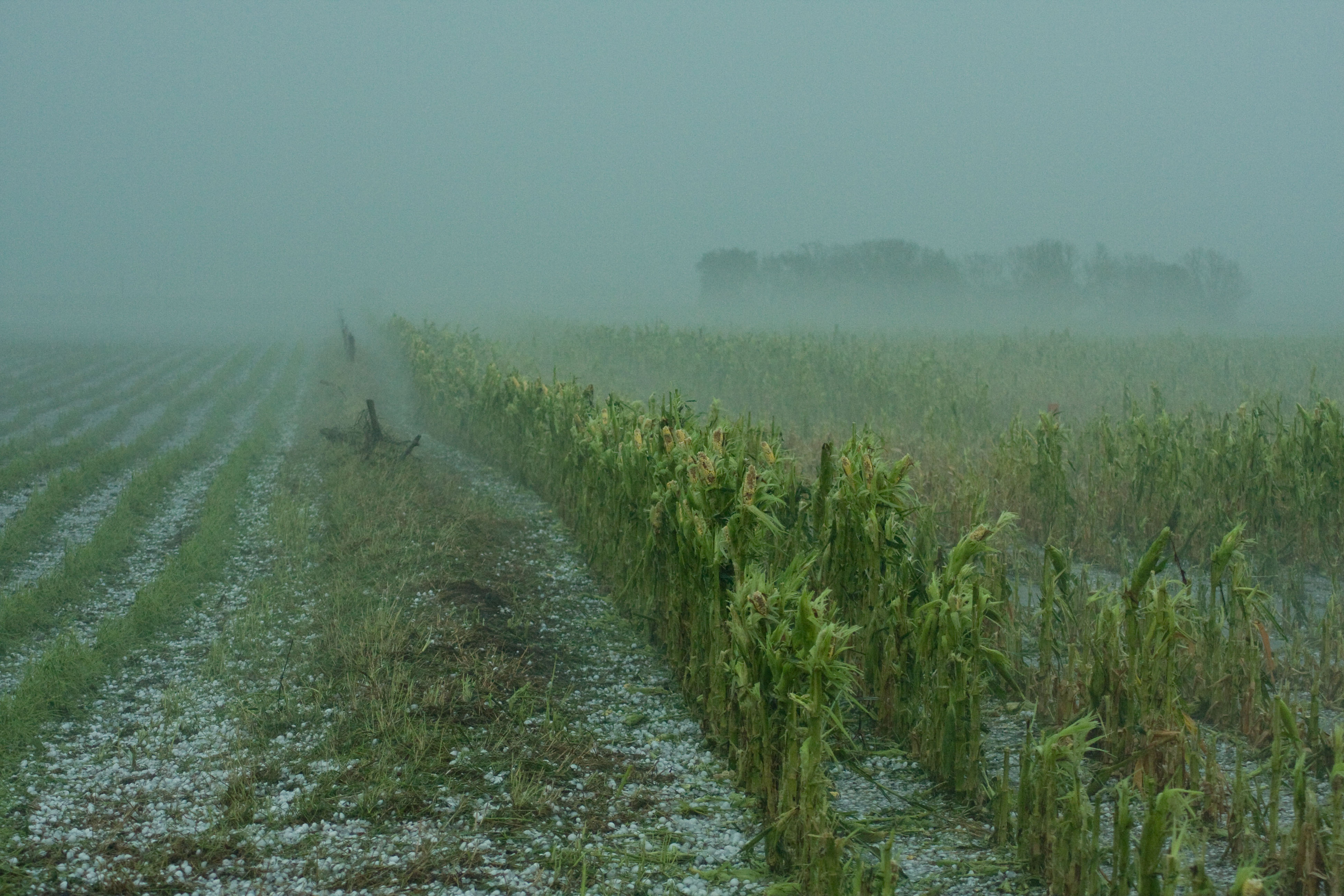
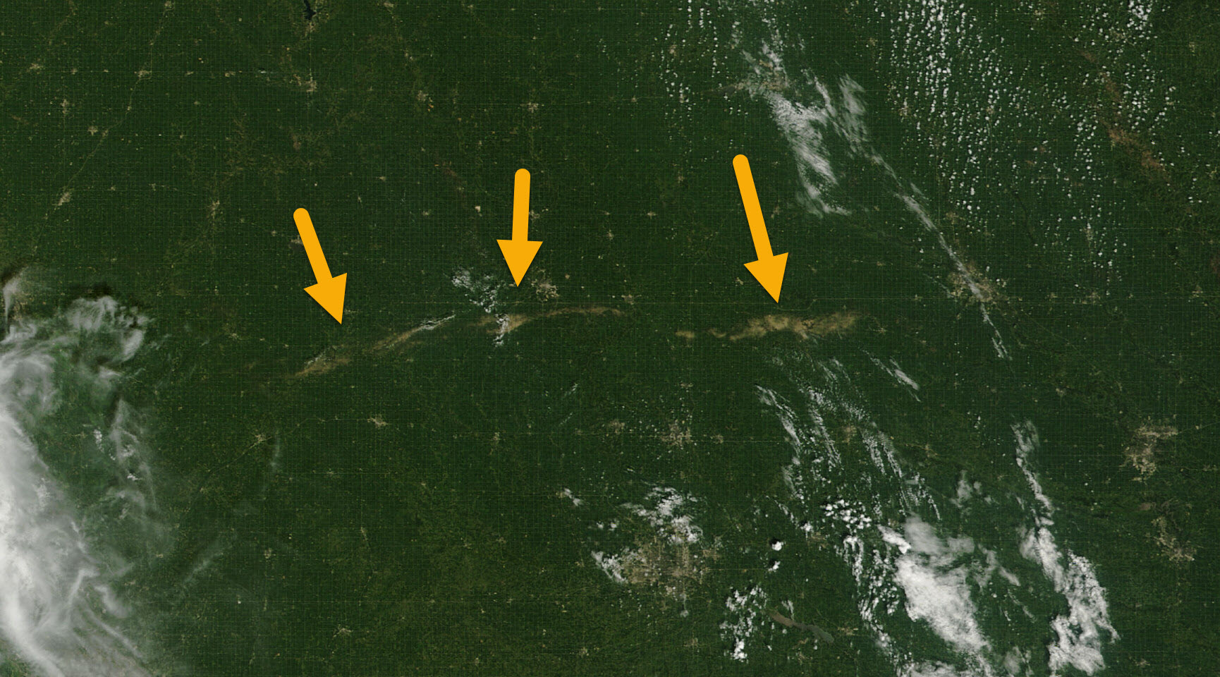
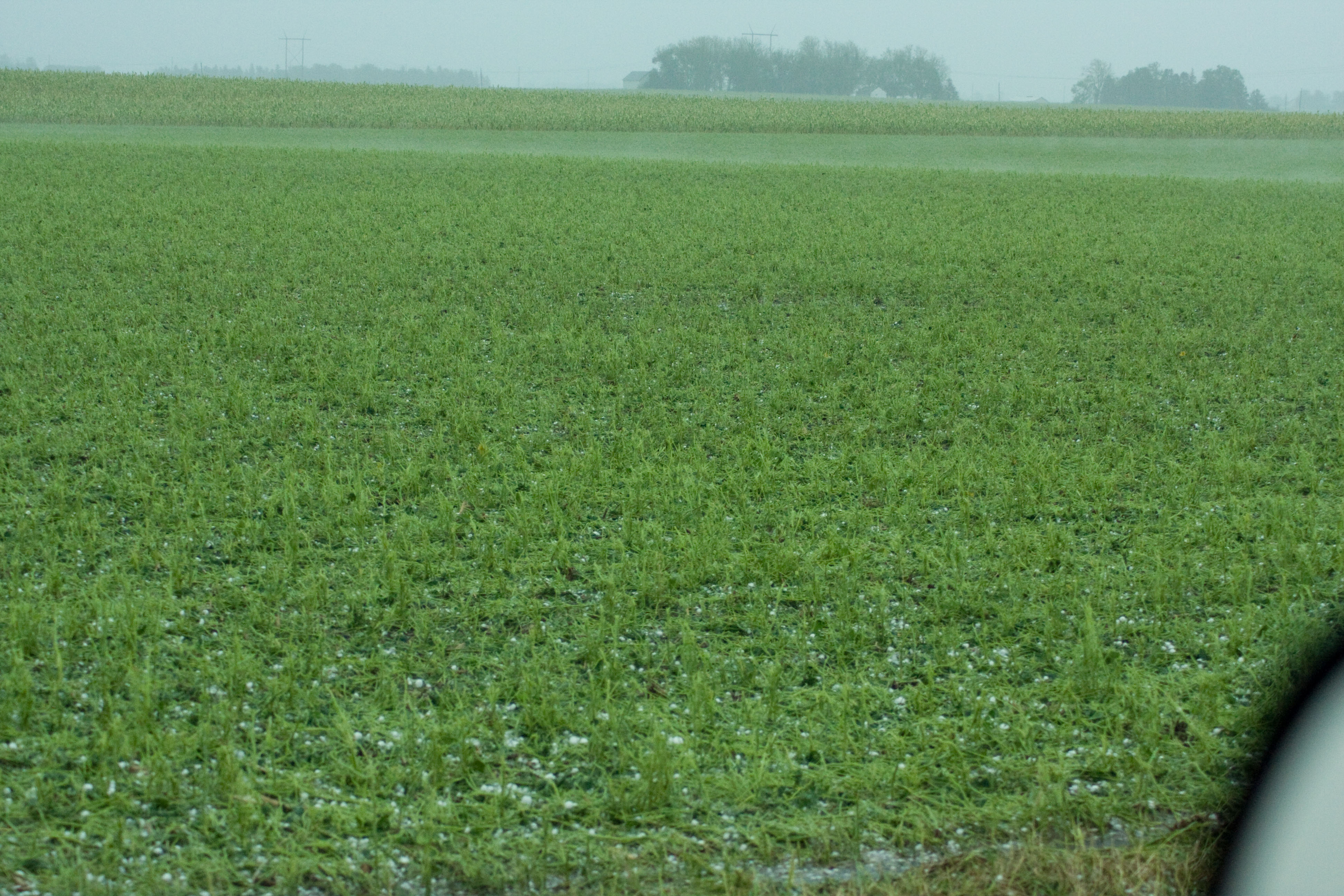
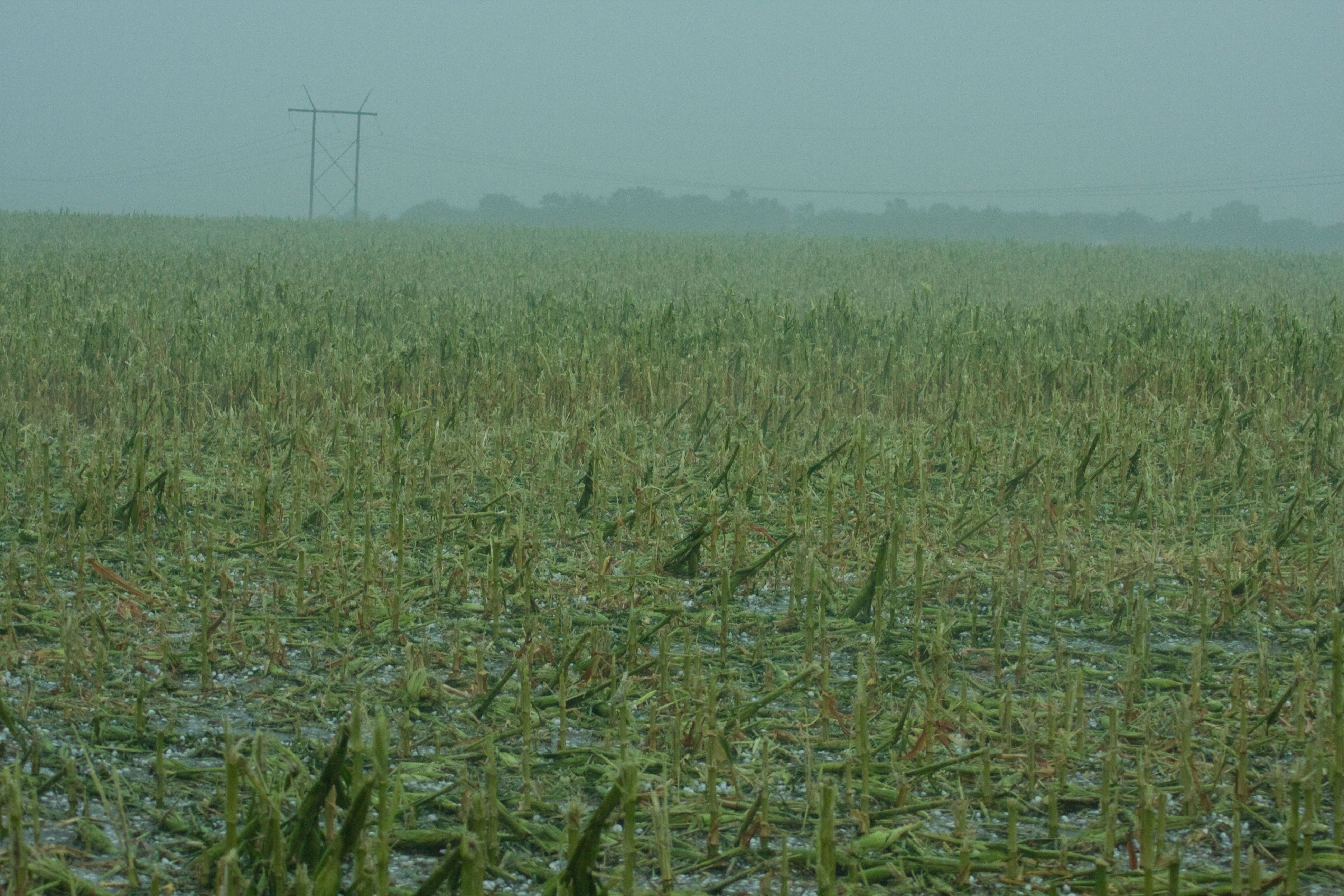
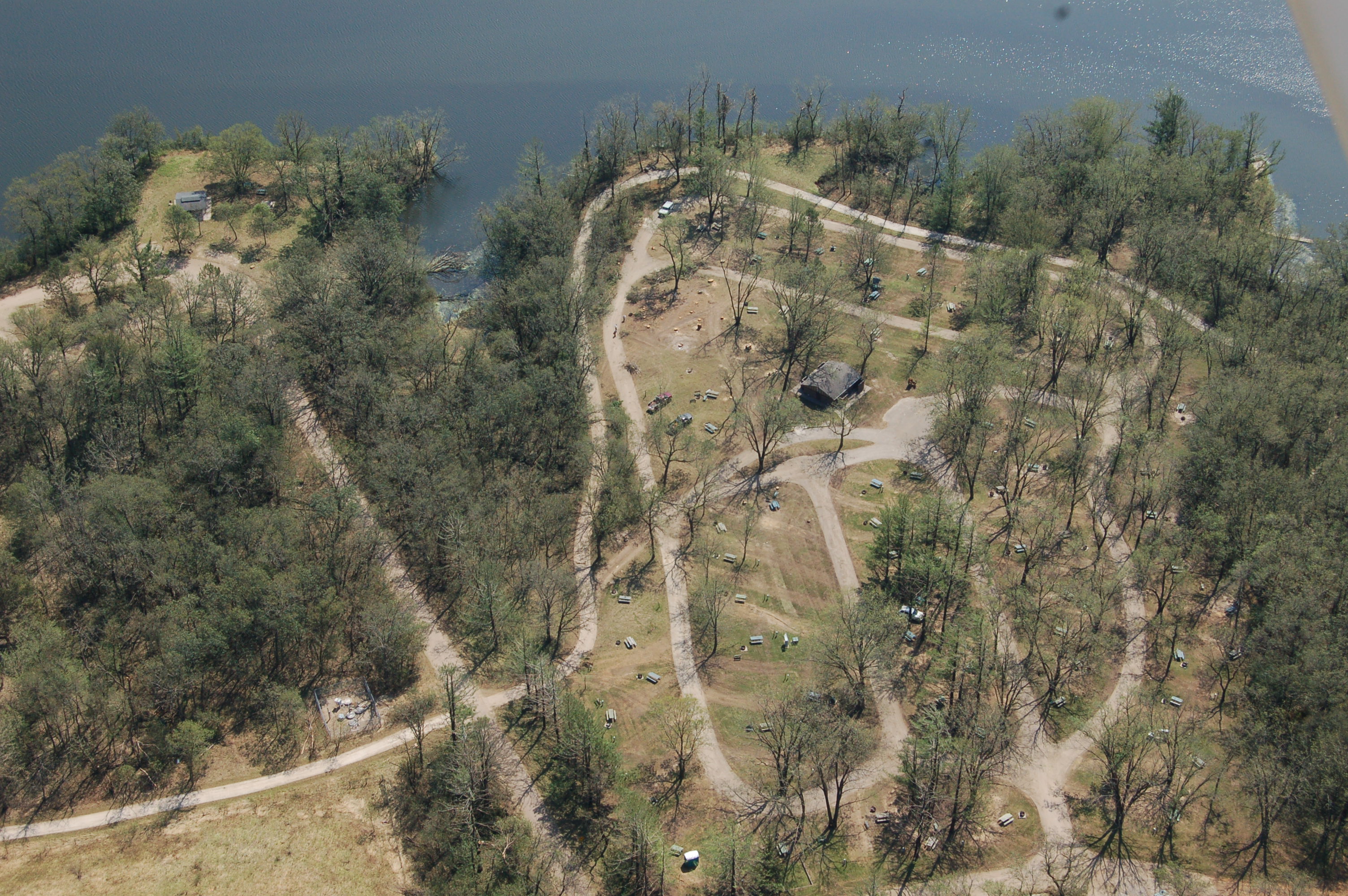
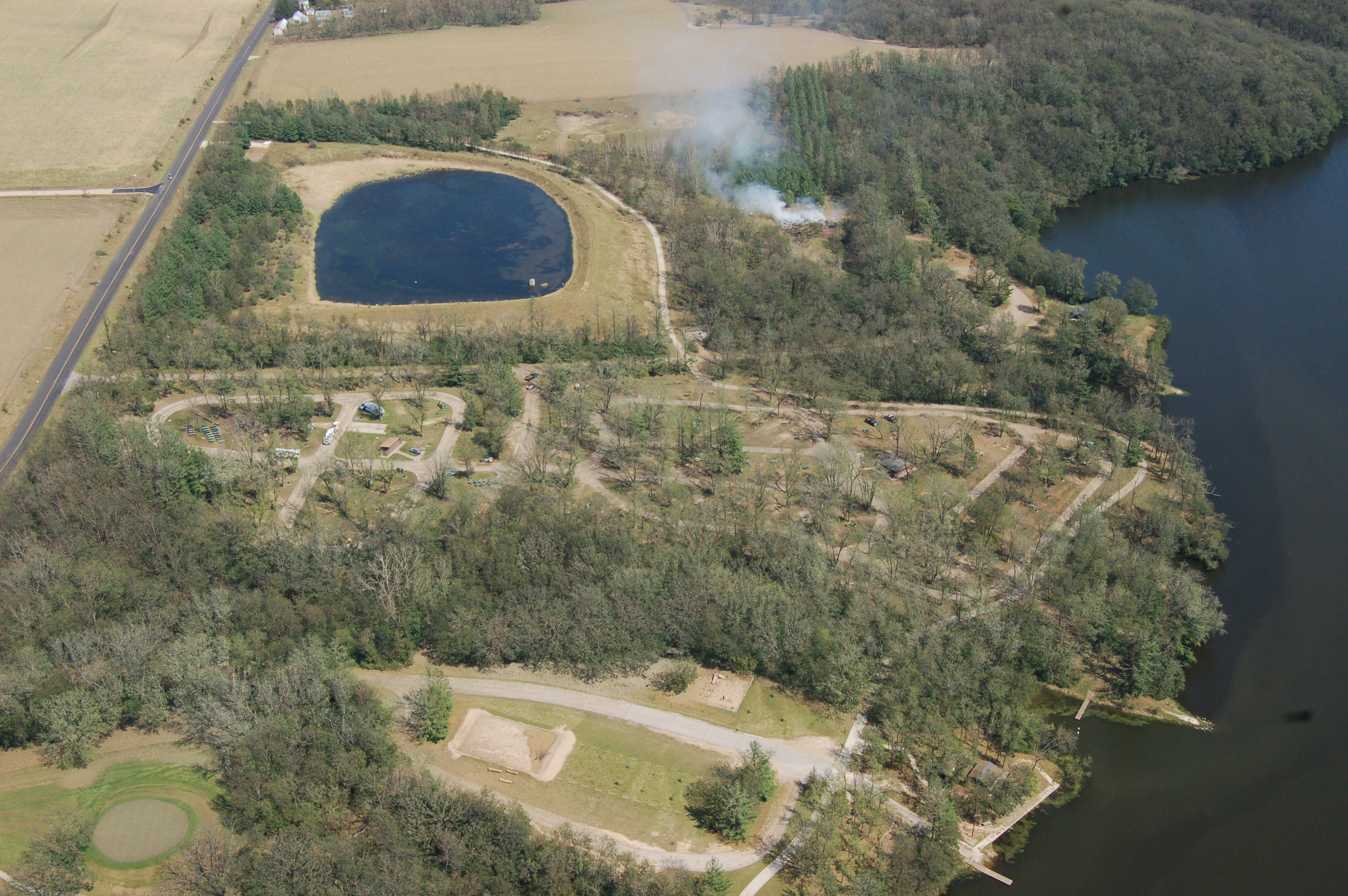
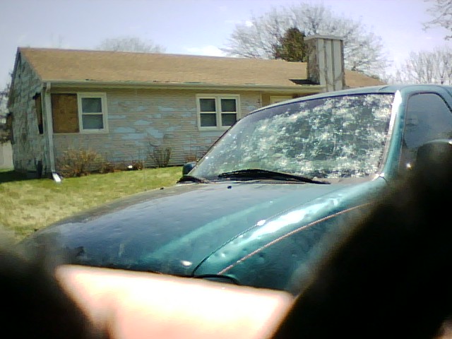
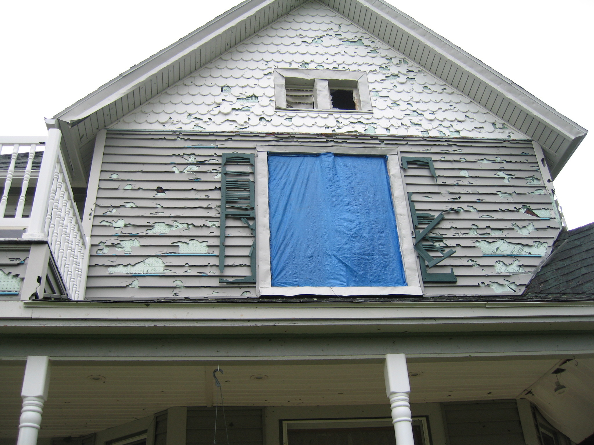
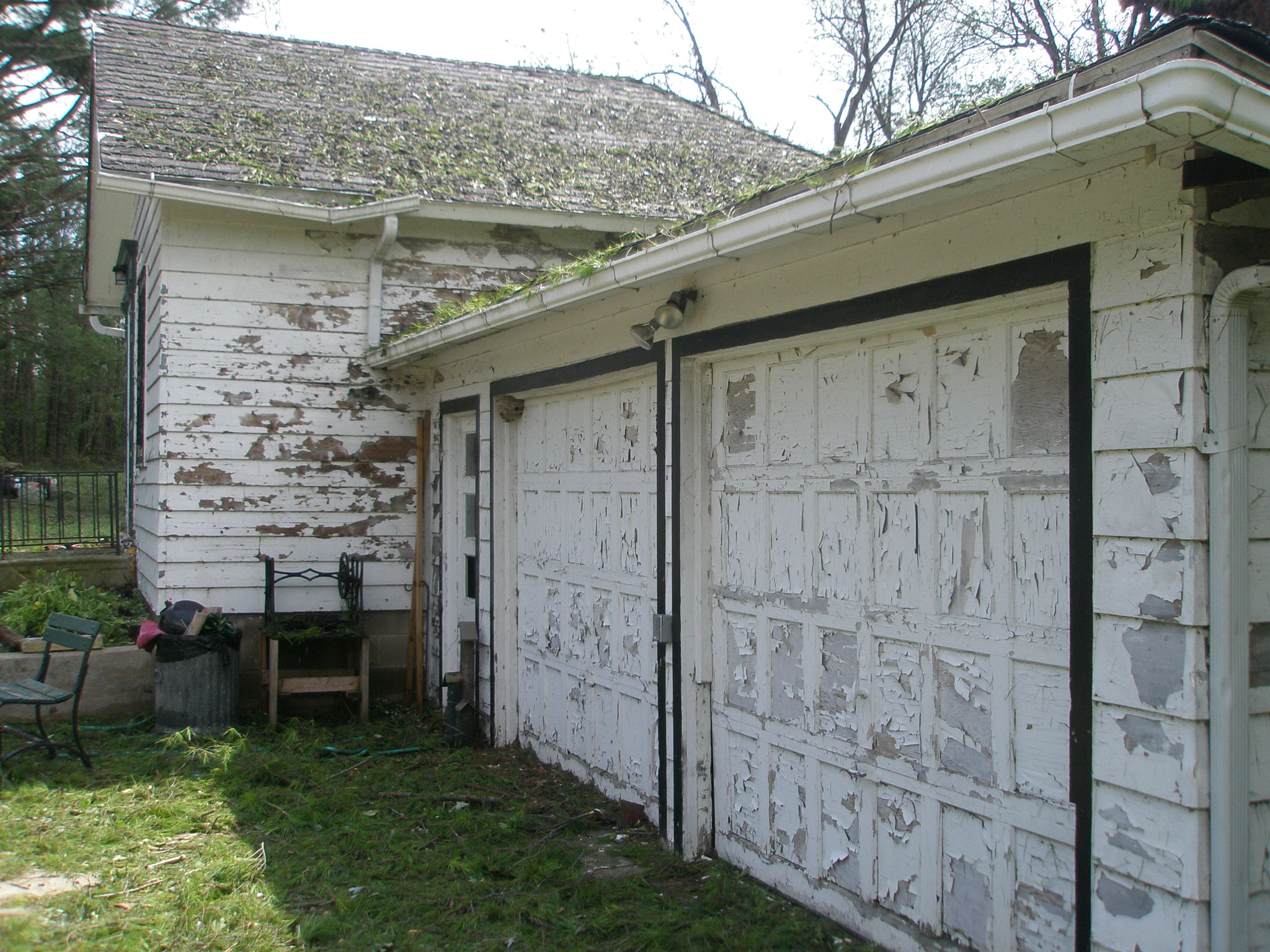
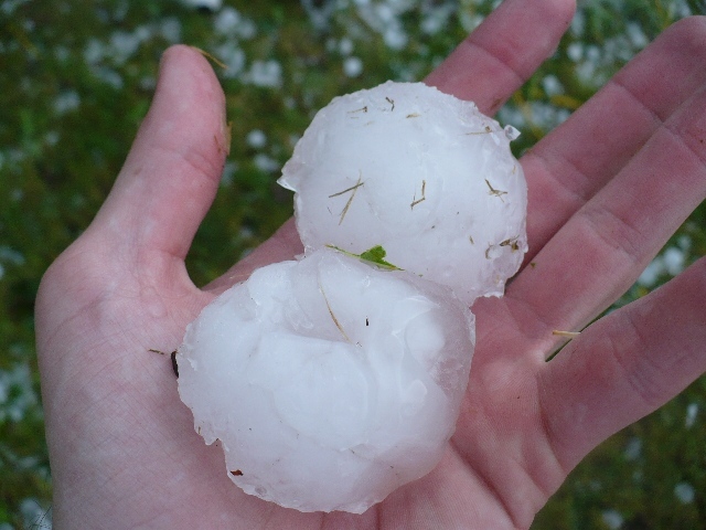
On the morning of August 9, 2009, an impressive supercell thunderstorm rolled across northern Iowa leaving roughly a 150-mile path of destruction that folks still talk about today. The storm began in west-central Iowa and quickly produced baseball size hail at 8:18 a.m. CT in Wall Lake, Iowa. This is somewhat unconventional given the time of day as strong storms of this nature typically develop during the peak heating of the day. Not long after the baseball hail, 75 mph winds (with the large hail) destroyed crops and broke many windows in and around the town of Somers, Iowa. Further east, an amazing video caught this wind-driven hail in Otho, Iowa. A 2-mile wide swath of hail damage to crops was found near Interstate 35 north of Ellsworth and that wasn’t even the strongest part of the storm. The photo at the bottom right was taken shortly after the storm near Callender, Iowa (south of Fort Dodge). Between 10:30 and 10:30 a.m. CDT, 102 mph winds were measured in Eldora with hail up to 3 inches in diameter! This combination caused devastating damage to every home in town and any vehicle not in a garage as well as severe tree and crop damage near Eldora. Prior to the storm, the corn was 6 feet tall and the beans were fully mature but were both completely shredded. Just northeast of Eldora, Pine Lake State Park received considerable amount of tree, building, and vehicle damage throughout the park (See image on the top right). The hail damage path was clearly visible from the air (See center image to the right). Speaking of viewing the damage from the air, MODIS (Moderate Resolution Imaging Spectroradiometer) took some amazing images from space. MODIS is aboard NASA’s Aqua and Terra satellites which are part of the Earth Observing System (EOS) program by NASA. These NASA satellites are polar orbiting satellites (polar vs geostationary) and the Terra and Aqua captured the crop damage swath across northern Iowa (See Figures 3 & 4). 45,000 acres of crops were deemed completely lost while 60% or greater loss of crops occurred on another 55,000 acres. In Hardin County alone, a 150 square mile area had substantial crop damage. The total estimated damage to crops were over $175 million across northern Iowa and 8 counties were declared a federal disaster area. Damage to the homes and vehicles in the town of Eldora were greater than the EF-5 tornado that struck Parkersburg in 2008. Wind-driven hail storms can and do produce catastrophic damage and in some cases even worse damage than tornadoes.
|
|
Photos:
A few photos from Eldora, Iowa and other locations that were hit by the large hail and damaging winds.
 |
 |
 |
 |
| Bean field near Callendar, Iowa. | Brick building with partial wall collapse in Marshalltown | Pine Lake State Park just northeast of Eldora, Iowa | Pine Lake State Park just northeast of Eldora, Iowa |
 |
 |
 |
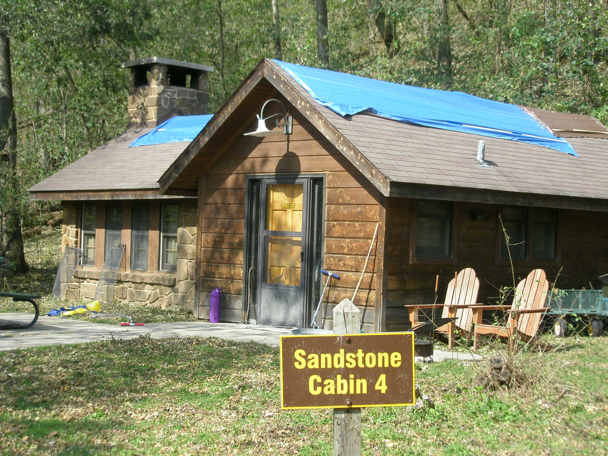 |
| Another aerial view of Pine Lake State Park. Pine Lake State Park photos courtesy of Don Primus. | Damaged home and vehicle in Eldora, Iowa. | Siding rip off home in Eldora, Iowa | Cabin with major hail damage in Pine Lake State Park. |
 |
 |
 |
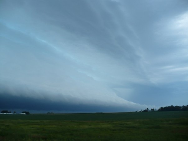 |
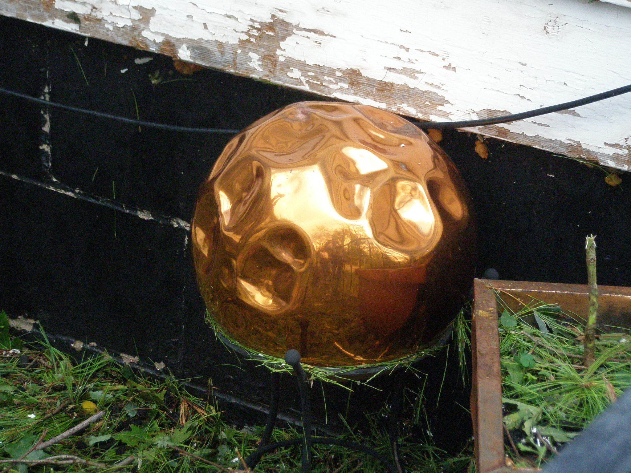
| More siding ripped off building in Pine Lake State Park. | Large hail from the storm. | Large hail impressions. Taken in Pine Lake State Park. | Impressive shelf cloud near Eldora. Photo courtesy of Craig Maire. |
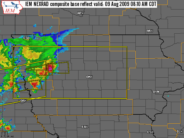
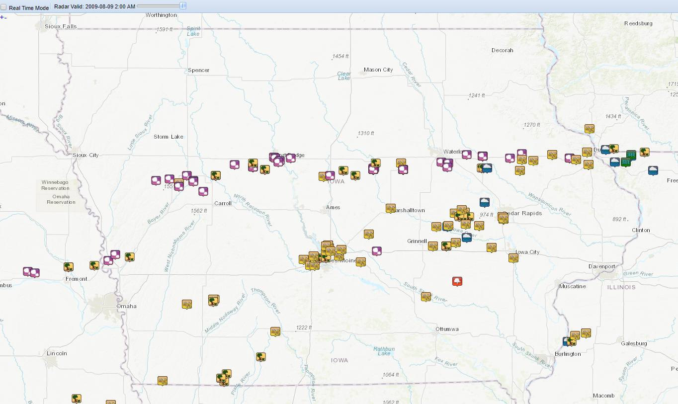
Radar:
Radar images of the supercell that tracked across northern Iowa from around Wall Lake to Eldora, Iowa on August 9, 2009.
 |
.png) |
|
Loop with warnings and reports |
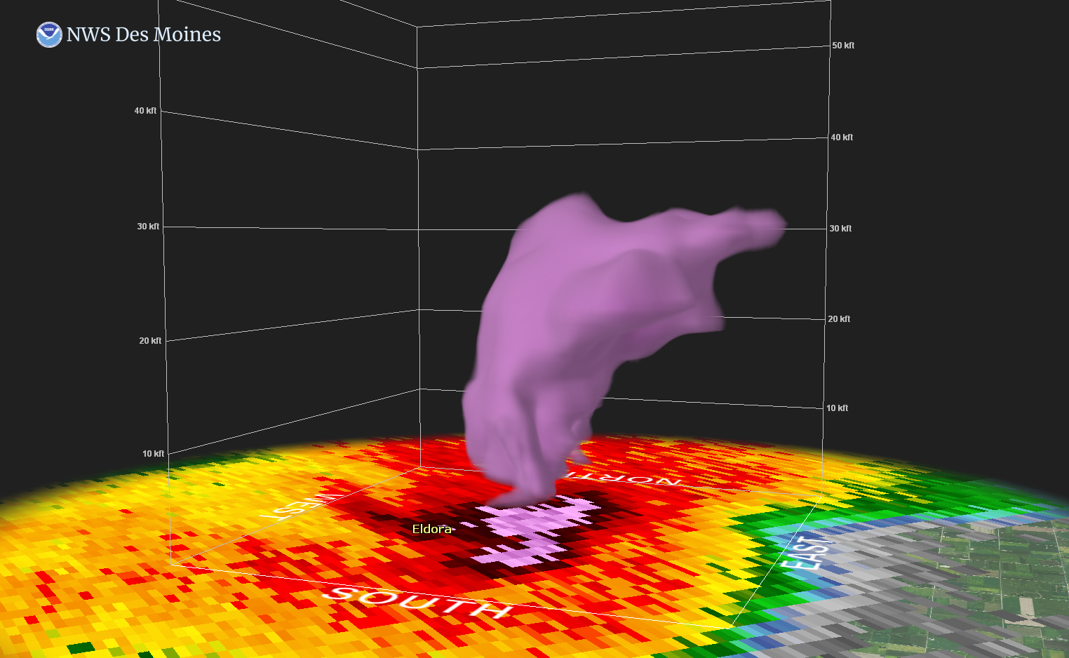
Cross-section of reflectivity when the storm was over Eldora, Iowa at 10:42 a.m. CT. The purples and whites indicate the hail core and very strong updraft. |
 |
 |
|
Base reflectivity loop beginning at 7:31 a.m. CT to 11:38 a.m. CT |
This is an 'All-tilts' loop when the storm rolled through Eldora, Iowa. The little red dot is the Pine Lake State Park. The radar samples the atmosphere by tilting the antenna slightly upward after each complete rotation. Thus, the radar is sampling the storm vertically through the atmosphere. The top of the storm as sampled by the 12.5° angle is around 70,000 feet. |
 |
 |
|
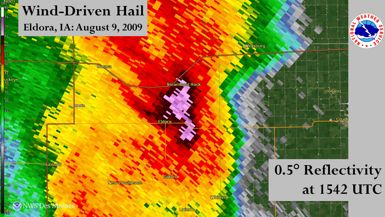
Base reflectivity of the storm beginning at 1300 UTC (8 a.m. CT) and ending at 1625 UTC (11:25 a.m. CT). The white outline is the crop damage from the wind-driven hail. Pink = 65 dBZ and White = 75 dBZ |
This is the Maximum Estimated Hail Size (MEHS) of the storm as it rolled through Eldora, Iowa. Notice the whites are 4 to 5 inch estimated hails size. |
 |
 |
|
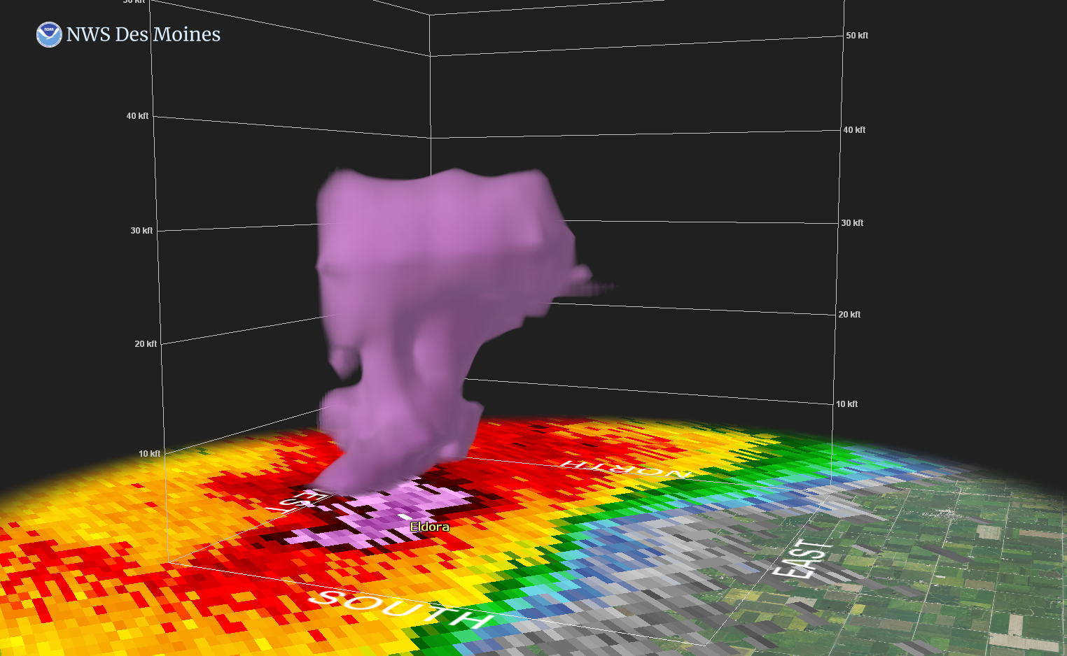
Volumtric look at the storm as it entered Eldora at 10:37 a.m. CT. |
Volumetric look at the storm as it went thru Eldora at 10:42 a.m. CT. |
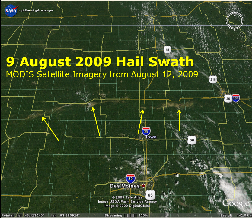
Satellite
Satellite images capture from MODIS via the TERRA and AQUA NASA satellites.
 |
 |
 |
|
The massive hail swath captured from NASA's Terra Satellite shows the devastating crop damage over portions of northern Iowa. Eldora, Iowa is in the center of the 3rd swath (far right arrow). |
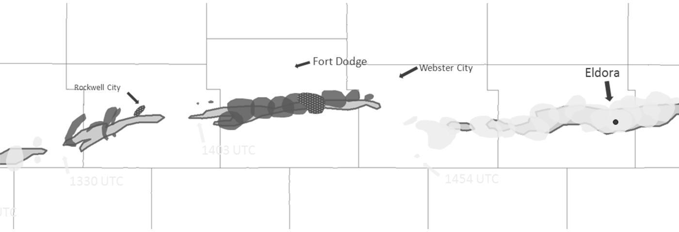
Map of the hail swath across northern Iowa. |
Another satellite image showing the massive hail swath across northern Iowa. |
Storm Reports
 PRELIMINARY LOCAL STORM REPORT...SUMMARY
NATIONAL WEATHER SERVICE DES MOINES IA
144 PM CDT SUN AUG 09 2009
..TIME... ...EVENT... ...CITY LOCATION... ...LAT.LON...
..DATE... ....MAG.... ..COUNTY LOCATION..ST.. ...SOURCE....
..REMARKS..
0816 AM HAIL 5 E ODEBOLT 42.31N 95.16W
08/09/2009 E1.00 INCH SAC IA TRAINED SPOTTER
0818 AM HAIL WALL LAKE 42.27N 95.09W
08/09/2009 E1.75 INCH SAC IA TRAINED SPOTTER
0827 AM HAIL BREDA 42.18N 94.98W
08/09/2009 E1.00 INCH CARROLL IA FIRE DEPT/RESCUE
FROM BREDA FD VIA CARROLL COUNTY SHERIFF
0830 AM HAIL 1 SE YETTER 42.31N 94.84W
08/09/2009 E1.50 INCH CALHOUN IA TRAINED SPOTTER
ESTIMATED PING PONG BALL SIZED HAIL BROKE OUT TWO WINDOWS
ON A HOUSE
0837 AM HAIL 1 SE YETTER 42.31N 94.84W
08/09/2009 E1.50 INCH CALHOUN IA TRAINED SPOTTER
0846 AM TSTM WND DMG 1 SE YETTER 42.31N 94.84W
08/09/2009 CALHOUN IA TRAINED SPOTTER
BROKEN BRANCHES 3 INCHES IN DIAMETER.
0850 AM HAIL ROCKWELL CITY 42.40N 94.63W
08/09/2009 M1.25 INCH CALHOUN IA TRAINED SPOTTER
0905 AM TSTM WND DMG SOMERS 42.38N 94.43W
08/09/2009 CALHOUN IA TRAINED SPOTTER
TRAINED SPOTTER REPORTS EXTENSIVE
TREE...WINDOW...ROOF...AND CROP DAMAGE FROM HIGH WINDS
AND LARGE HAIL AROUND SOMERS. DELAYED REPORT. TIME
ESTIMATED.
0910 AM TSTM WND DMG NE SOMERS 42.38N 94.43W
08/09/2009 CALHOUN IA TRAINED SPOTTER
LARGE TREE, ESTIMATED 1 FOOT IN DIAMETER, BLOWN OVER ONTO
CAR IN SOMERS. ESTIMATED QUATER SIZED HAIL ALSO BROKE
HOUSE WINDOWS
0910 AM HAIL NE SOMERS 42.38N 94.43W
08/09/2009 E1.00 INCH CALHOUN IA TRAINED SPOTTER
0912 AM TSTM WND DMG 2 N SOMERS 42.41N 94.43W
08/09/2009 CALHOUN IA TRAINED SPOTTER
MODULAR HOME LOST PART OF ROOF AND WEST SIDE OF HOME DUE
TO HIGH WINDS
0915 AM TSTM WND DMG CALLENDER 42.36N 94.30W
08/09/2009 WEBSTER IA TRAINED SPOTTER
TRAINED SPOTTER REPORTS EXTENSIVE
TREE...WINDOW...ROOF...AND CROP DAMAGE FROM HIGH WINDS
AND LARGE HAIL AROUND CALLENDER. DELAYED REPORT. TIME
ESTIMATED. SPOTTER ALSO REPORTED 1 INCH DIAMETER HAIL
REMAINED ON THE GROUND IN CALLENDER AT 1015 AM.
0919 AM TSTM WND DMG CALLENDER 42.36N 94.30W
08/09/2009 WEBSTER IA AMATEUR RADIO
AMATEUR SKYWARN SPOTTER REPORTED DOWNED TREES AND ROOF
DAMAGE DUE TO SILVER DOLLAR HAIL AND WIND IN EXCESS OF 60
MPH.
0919 AM HAIL 4 SSW FORT DODGE 42.46N 94.20W
08/09/2009 M1.00 INCH WEBSTER IA TRAINED SPOTTER
0919 AM HAIL ELDORA 42.36N 93.10W
08/09/2009 E1.75 INCH HARDIN IA TRAINED SPOTTER
HAIL IS AT LEAST GOLF-BALL SIZED CAUSING BROKEN WINDOWS.
0930 AM HAIL 4 S FORT DODGE 42.45N 94.18W
08/09/2009 E1.00 INCH WEBSTER IA TRAINED SPOTTER
0930 AM HAIL 1 NE OTHO 42.43N 94.13W
08/09/2009 E1.75 INCH WEBSTER IA TRAINED SPOTTER
TRAINED SPOTTER REPORTS LARGER THAN GOLF BALL SIZED HAIL
FELL AT NELSON AVENUE AND WOODMANS HOLLOW ROAD NORTH OF
COALVILLE. ALSO REPORTS SMALL BRANCHES DOWN FROM HIGH
WINDS. DELAYED REPORT. TIME ESTIMATED. SPOTTER ALSO
REPORTS THAT GOLF BALL HAIL REMAINS ON THE GROUND NEAR
OTHO AT 1015 AM.
0935 AM HAIL NW OTHO 42.42N 94.15W
08/09/2009 E1.75 INCH WEBSTER IA TRAINED SPOTTER
HOUSE WINDOWS BROKEN
0940 AM HAIL 2 SSW DUNCOMBE 42.45N 94.01W
08/09/2009 E1.00 INCH WEBSTER IA TRAINED SPOTTER
1000 AM TSTM WND GST 1 SW JEWELL 42.30N 93.65W
08/09/2009 M68.00 MPH HAMILTON IA TRAINED SPOTTER
1005 AM HAIL ELLSWORTH 42.31N 93.58W
08/09/2009 E1.00 INCH HAMILTON IA LAW ENFORCEMENT
WINDSHIELD OF CAR BROKEN BY HAIL
1014 AM TSTM WND DMG 2 N RADCLIFFE 42.35N 93.43W
08/09/2009 HARDIN IA TRAINED SPOTTER
EXTENSIVE HOUSE AND CROP DAMAGE. SEVERAL HOUSES WITH
WINDOWS BROKEN FROM HAIL ON WEST SIDES OF BUILDINGS. CROP
DAMAGE SWATH A MILE TO A MILE AND A HALF WIDE. DELAYED
REPORT.
1026 AM TSTM WND DMG S HUBBARD 42.31N 93.30W
08/09/2009 HARDIN IA TRAINED SPOTTER
LARGE TREE BRANCHES UP TO 1 FOOT IN DIAMETER DOWN ACROSS
YARD. ONE HALF INCH HAIL. TORRENTIAL RAIN.
1040 AM HAIL ELDORA 42.36N 93.10W
08/09/2009 M3.00 INCH HARDIN IA TRAINED SPOTTER
SPOTTER MEASURED LARGEST HAIL FOUND
1040 AM HAIL ELDORA 42.36N 93.10W
08/09/2009 E2.00 INCH HARDIN IA TRAINED SPOTTER
TRAINED SPOTTER IN ELDORA REPORTS HAIL A LITTLE LARGER
THAN GOLF BALLS. SIDING AND ALL WINDOWS ON NORTH AND WEST
SIDES OF RESIDENCE BROKEN WITH HAIL STONES FLYING INTO
THE HOME. TREES SHREDDED AND ONE TREE FELL ONTO A POWER
LINE. TIME ESTIMATED.
1040 AM HAIL ELDORA 42.36N 93.10W
08/09/2009 E1.75 INCH HARDIN IA TRAINED SPOTTER
HAIL AT LEAST GOLF-BALL SIZE HAS BROKEN WINDOWS AT
RESIDENCE.
1040 AM HAIL 1 NE ELDORA 42.37N 93.09W
08/09/2009 E1.00 INCH HARDIN IA TRAINED SPOTTER
1 INCH HAIL REPORTED IN PINE LAKE STATE PARK
1040 AM HAIL ELDORA 42.36N 93.10W
08/09/2009 E2.50 INCH HARDIN IA TRAINED SPOTTER
HOUSE WINDOWS BROKEN. CAR EXTENSIVELY DAMAGED.
1040 AM TSTM WND DMG ELDORA 42.36N 93.10W
08/09/2009 HARDIN IA TRAINED SPOTTER
4 FOOT DIAMETER TREE BLOWN DOWN. LIVE POWER LINES DOWN.
1040 AM HAIL N ELDORA 42.37N 93.10W
08/09/2009 E1.25 INCH HARDIN IA TRAINED SPOTTER
ESTIMATED QUATER TO HALF DOLLAR SIZED HAIL. WINDOWS
BROKEN BY HAIL.
1040 AM TSTM WND DMG ELDORA 42.36N 93.10W
08/09/2009 HARDIN IA TRAINED SPOTTER
5 FOOT DIAMETER TREES BLOWN DOWN. 3 FOOT DIAMETER
BRANCHES BLOWN FROM TREES.
1058 AM TSTM WND GST GRUNDY CENTER 42.36N 92.77W
08/09/2009 E65.00 MPH GRUNDY IA AMATEUR RADIO
AMATEUR RADIO SPOTTER ESTIMATED WIND GUSTS OF 60-65 MPH
AND POWER IS OUT IN GRUNDY CENTER. NO HAIL AT THIS TIME.
1100 AM TSTM WND DMG GRUNDY CENTER 42.36N 92.77W
08/09/2009 GRUNDY IA AMATEUR RADIO
4 TO 8 INCH TREE LIMBS DOWN
1100 AM TSTM WND DMG SSE GRUNDY CENTER 42.36N 92.77W
08/09/2009 GRUNDY IA TRAINED SPOTTER
ESTIMATED 2.5 TO 3 INCH TREE BRANCHES DOWN AND NICKEL
SIZED HAIL
1102 AM TSTM WND GST 4 NNW GRUNDY CENTER 42.41N 92.79W
08/09/2009 E70.00 MPH GRUNDY IA TRAINED SPOTTER
SHINGLE DEBRIS FLYING WITH WINDS ESTIMATED TO 70 MPH.
ALSO HAS GOLFBALL SIZE HAIL.
1111 AM HAIL GRUNDY CENTER 42.36N 92.77W
08/09/2009 E1.00 INCH GRUNDY IA AMATEUR RADIO
1140 AM HAIL 5 S WATERLOO 42.42N 92.35W
08/09/2009 E1.00 INCH BLACK HAWK IA BROADCAST MEDIA
PEA TO QUARTER HAIL AND NEAR ZERO VISIBILITY IN HEAVY
RAIN...FROM KWWL TV VIEWER.
1140 AM HAIL 4 S EVANSDALE 42.40N 92.28W
08/09/2009 E1.00 INCH BLACK HAWK IA TRAINED SPOTTER
1 INCH HAIL IN WASHBURN
1144 AM HAIL 5 S EVANSDALE 42.38N 92.28W
08/09/2009 E1.00 INCH BLACK HAWK IA TRAINED SPOTTER
&&
SUMMARY OF REPORTS THROUGH 143 PM.
$$
SMALL
PRELIMINARY LOCAL STORM REPORT...SUMMARY
NATIONAL WEATHER SERVICE DES MOINES IA
144 PM CDT SUN AUG 09 2009

..TIME...   ...EVENT...      ...CITY LOCATION...     ...LAT.LON...
..DATE...   ....MAG....      ..COUNTY LOCATION..ST.. ...SOURCE....
            ..REMARKS..

0816 AM     HAIL             5 E ODEBOLT             42.31N 95.16W
08/09/2009  E1.00 INCH       SAC                IA   TRAINED SPOTTER

0818 AM     HAIL             WALL LAKE               42.27N 95.09W
08/09/2009  E1.75 INCH       SAC                IA   TRAINED SPOTTER

0827 AM     HAIL             BREDA                   42.18N 94.98W
08/09/2009  E1.00 INCH       CARROLL            IA   FIRE DEPT/RESCUE

            FROM BREDA FD VIA CARROLL COUNTY SHERIFF

0830 AM     HAIL             1 SE YETTER             42.31N 94.84W
08/09/2009  E1.50 INCH       CALHOUN            IA   TRAINED SPOTTER

            ESTIMATED PING PONG BALL SIZED HAIL BROKE OUT TWO WINDOWS
            ON A HOUSE

0837 AM     HAIL             1 SE YETTER             42.31N 94.84W
08/09/2009  E1.50 INCH       CALHOUN            IA   TRAINED SPOTTER

0846 AM     TSTM WND DMG     1 SE YETTER             42.31N 94.84W
08/09/2009                   CALHOUN            IA   TRAINED SPOTTER

            BROKEN BRANCHES 3 INCHES IN DIAMETER.

0850 AM     HAIL             ROCKWELL CITY           42.40N 94.63W
08/09/2009  M1.25 INCH       CALHOUN            IA   TRAINED SPOTTER

0905 AM     TSTM WND DMG     SOMERS                  42.38N 94.43W
08/09/2009                   CALHOUN            IA   TRAINED SPOTTER

            TRAINED SPOTTER REPORTS EXTENSIVE
            TREE...WINDOW...ROOF...AND CROP DAMAGE FROM HIGH WINDS
            AND LARGE HAIL AROUND SOMERS. DELAYED REPORT. TIME
            ESTIMATED.

0910 AM     TSTM WND DMG     NE SOMERS               42.38N 94.43W
08/09/2009                   CALHOUN            IA   TRAINED SPOTTER

            LARGE TREE, ESTIMATED 1 FOOT IN DIAMETER, BLOWN OVER ONTO
            CAR IN SOMERS. ESTIMATED QUATER SIZED HAIL ALSO BROKE
            HOUSE WINDOWS

0910 AM     HAIL             NE SOMERS               42.38N 94.43W
08/09/2009  E1.00 INCH       CALHOUN            IA   TRAINED SPOTTER

0912 AM     TSTM WND DMG     2 N SOMERS              42.41N 94.43W
08/09/2009                   CALHOUN            IA   TRAINED SPOTTER

            MODULAR HOME LOST PART OF ROOF AND WEST SIDE OF HOME DUE
            TO HIGH WINDS

0915 AM     TSTM WND DMG     CALLENDER               42.36N 94.30W
08/09/2009                   WEBSTER            IA   TRAINED SPOTTER

            TRAINED SPOTTER REPORTS EXTENSIVE
            TREE...WINDOW...ROOF...AND CROP DAMAGE FROM HIGH WINDS
            AND LARGE HAIL AROUND CALLENDER. DELAYED REPORT. TIME
            ESTIMATED. SPOTTER ALSO REPORTED 1 INCH DIAMETER HAIL
            REMAINED ON THE GROUND IN CALLENDER AT 1015 AM.

0919 AM     TSTM WND DMG     CALLENDER               42.36N 94.30W
08/09/2009                   WEBSTER            IA   AMATEUR RADIO

            AMATEUR SKYWARN SPOTTER REPORTED DOWNED TREES AND ROOF
            DAMAGE DUE TO SILVER DOLLAR HAIL AND WIND IN EXCESS OF 60
            MPH.

0919 AM     HAIL             4 SSW FORT DODGE        42.46N 94.20W
08/09/2009  M1.00 INCH       WEBSTER            IA   TRAINED SPOTTER

0919 AM     HAIL             ELDORA                  42.36N 93.10W
08/09/2009  E1.75 INCH       HARDIN             IA   TRAINED SPOTTER

            HAIL IS AT LEAST GOLF-BALL SIZED CAUSING BROKEN WINDOWS.

0930 AM     HAIL             4 S FORT DODGE          42.45N 94.18W
08/09/2009  E1.00 INCH       WEBSTER            IA   TRAINED SPOTTER

0930 AM     HAIL             1 NE OTHO               42.43N 94.13W
08/09/2009  E1.75 INCH       WEBSTER            IA   TRAINED SPOTTER

            TRAINED SPOTTER REPORTS LARGER THAN GOLF BALL SIZED HAIL
            FELL AT NELSON AVENUE AND WOODMANS HOLLOW ROAD NORTH OF
            COALVILLE. ALSO REPORTS SMALL BRANCHES DOWN FROM HIGH
            WINDS. DELAYED REPORT. TIME ESTIMATED. SPOTTER ALSO
            REPORTS THAT GOLF BALL HAIL REMAINS ON THE GROUND NEAR
            OTHO AT 1015 AM.

0935 AM     HAIL             NW OTHO                 42.42N 94.15W
08/09/2009  E1.75 INCH       WEBSTER            IA   TRAINED SPOTTER

            HOUSE WINDOWS BROKEN

0940 AM     HAIL             2 SSW DUNCOMBE          42.45N 94.01W
08/09/2009  E1.00 INCH       WEBSTER            IA   TRAINED SPOTTER

1000 AM     TSTM WND GST     1 SW JEWELL             42.30N 93.65W
08/09/2009  M68.00 MPH       HAMILTON           IA   TRAINED SPOTTER

1005 AM     HAIL             ELLSWORTH               42.31N 93.58W
08/09/2009  E1.00 INCH       HAMILTON           IA   LAW ENFORCEMENT

            WINDSHIELD OF CAR BROKEN BY HAIL

1014 AM     TSTM WND DMG     2 N RADCLIFFE           42.35N 93.43W
08/09/2009                   HARDIN             IA   TRAINED SPOTTER

            EXTENSIVE HOUSE AND CROP DAMAGE. SEVERAL HOUSES WITH
            WINDOWS BROKEN FROM HAIL ON WEST SIDES OF BUILDINGS. CROP
            DAMAGE SWATH A MILE TO A MILE AND A HALF WIDE. DELAYED
            REPORT.

1026 AM     TSTM WND DMG     S HUBBARD               42.31N 93.30W
08/09/2009                   HARDIN             IA   TRAINED SPOTTER

            LARGE TREE BRANCHES UP TO 1 FOOT IN DIAMETER DOWN ACROSS
            YARD. ONE HALF INCH HAIL. TORRENTIAL RAIN.

1040 AM     HAIL             ELDORA                  42.36N 93.10W
08/09/2009  M3.00 INCH       HARDIN             IA   TRAINED SPOTTER

            SPOTTER MEASURED LARGEST HAIL FOUND

1040 AM     HAIL             ELDORA                  42.36N 93.10W
08/09/2009  E2.00 INCH       HARDIN             IA   TRAINED SPOTTER

            TRAINED SPOTTER IN ELDORA REPORTS HAIL A LITTLE LARGER
            THAN GOLF BALLS. SIDING AND ALL WINDOWS ON NORTH AND WEST
            SIDES OF RESIDENCE BROKEN WITH HAIL STONES FLYING INTO
            THE HOME. TREES SHREDDED AND ONE TREE FELL ONTO A POWER
            LINE. TIME ESTIMATED.

1040 AM     HAIL             ELDORA                  42.36N 93.10W
08/09/2009  E1.75 INCH       HARDIN             IA   TRAINED SPOTTER

            HAIL AT LEAST GOLF-BALL SIZE HAS BROKEN WINDOWS AT
            RESIDENCE.

1040 AM     HAIL             1 NE ELDORA             42.37N 93.09W
08/09/2009  E1.00 INCH       HARDIN             IA   TRAINED SPOTTER

            1 INCH HAIL REPORTED IN PINE LAKE STATE PARK

1040 AM     HAIL             ELDORA                  42.36N 93.10W
08/09/2009  E2.50 INCH       HARDIN             IA   TRAINED SPOTTER

            HOUSE WINDOWS BROKEN. CAR EXTENSIVELY DAMAGED.

1040 AM     TSTM WND DMG     ELDORA                  42.36N 93.10W
08/09/2009                   HARDIN             IA   TRAINED SPOTTER

            4 FOOT DIAMETER TREE BLOWN DOWN. LIVE POWER LINES DOWN.

1040 AM     HAIL             N ELDORA                42.37N 93.10W
08/09/2009  E1.25 INCH       HARDIN             IA   TRAINED SPOTTER

            ESTIMATED QUATER TO HALF DOLLAR SIZED HAIL. WINDOWS
            BROKEN BY HAIL.

1040 AM     TSTM WND DMG     ELDORA                  42.36N 93.10W
08/09/2009                   HARDIN             IA   TRAINED SPOTTER

            5 FOOT DIAMETER TREES BLOWN DOWN. 3 FOOT DIAMETER
            BRANCHES BLOWN FROM TREES.

1058 AM     TSTM WND GST     GRUNDY CENTER           42.36N 92.77W
08/09/2009  E65.00 MPH       GRUNDY             IA   AMATEUR RADIO

            AMATEUR RADIO SPOTTER ESTIMATED WIND GUSTS OF 60-65 MPH
            AND POWER IS OUT IN GRUNDY CENTER. NO HAIL AT THIS TIME.

1100 AM     TSTM WND DMG     GRUNDY CENTER           42.36N 92.77W
08/09/2009                   GRUNDY             IA   AMATEUR RADIO

            4 TO 8 INCH TREE LIMBS DOWN

1100 AM     TSTM WND DMG     SSE GRUNDY CENTER       42.36N 92.77W
08/09/2009                   GRUNDY             IA   TRAINED SPOTTER

            ESTIMATED 2.5 TO 3 INCH TREE BRANCHES DOWN AND NICKEL
            SIZED HAIL

1102 AM     TSTM WND GST     4 NNW GRUNDY CENTER     42.41N 92.79W
08/09/2009  E70.00 MPH       GRUNDY             IA   TRAINED SPOTTER

            SHINGLE DEBRIS FLYING WITH WINDS ESTIMATED TO 70 MPH.
            ALSO HAS GOLFBALL SIZE HAIL.

1111 AM     HAIL             GRUNDY CENTER           42.36N 92.77W
08/09/2009  E1.00 INCH       GRUNDY             IA   AMATEUR RADIO

1140 AM     HAIL             5 S WATERLOO            42.42N 92.35W
08/09/2009  E1.00 INCH       BLACK HAWK         IA   BROADCAST MEDIA

            PEA TO QUARTER HAIL AND NEAR ZERO VISIBILITY IN HEAVY
            RAIN...FROM KWWL TV VIEWER.

1140 AM     HAIL             4 S EVANSDALE           42.40N 92.28W
08/09/2009  E1.00 INCH       BLACK HAWK         IA   TRAINED SPOTTER

            1 INCH HAIL IN WASHBURN

1144 AM     HAIL             5 S EVANSDALE           42.38N 92.28W
08/09/2009  E1.00 INCH       BLACK HAWK         IA   TRAINED SPOTTER


&&
SUMMARY OF REPORTS THROUGH 143 PM.
$$

SMALL