Overview
|
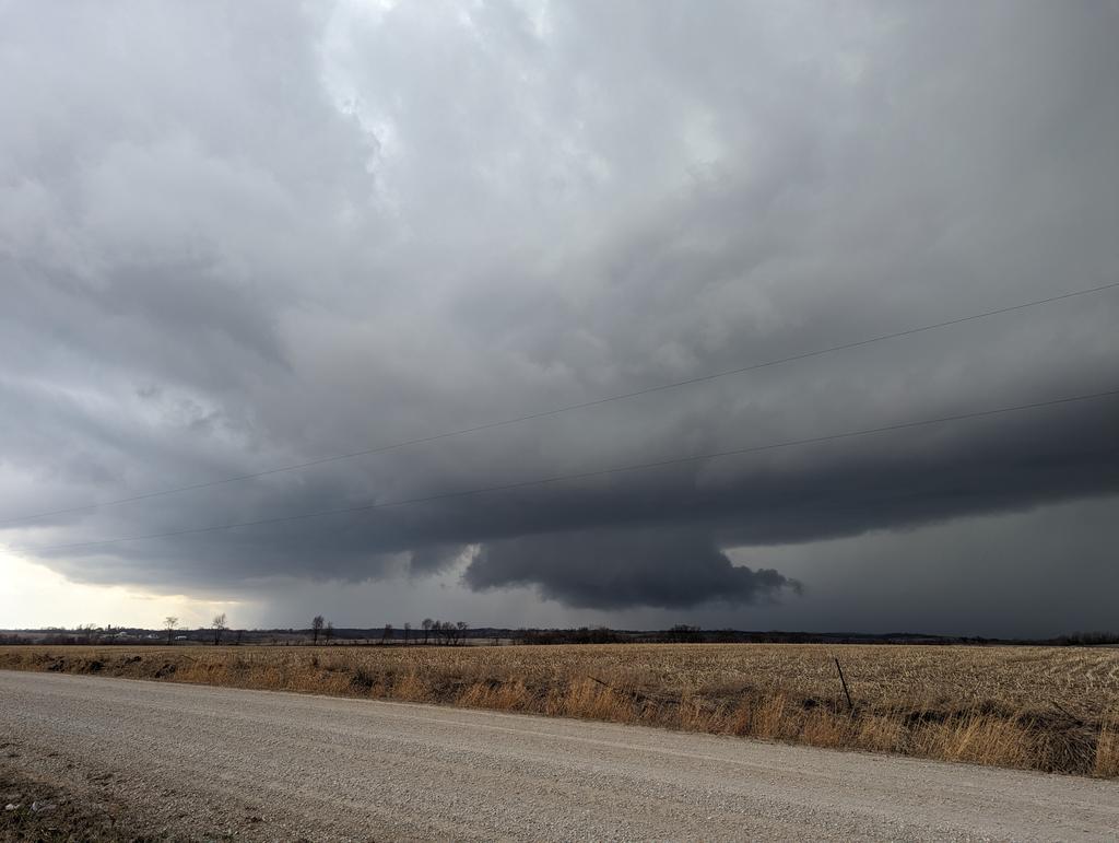
An intense storm system tracked across the state of Iowa on Friday, March 31st. This system pulled unseasonably warm and moist conditions into the Midwest, which coupled with a very favorable wind profile, and created quite the volatile environment for severe thunderstorms. This produced several long lived supercells which developed across central Iowa during the afternoon. The storms were prolific hail producers along with a few reports of wind damage as they moved rapidly northeast. Eventually, the storms produced a few tornadoes before exiting into eastern Iowa.
Other NWS Office Event Summaries:
Last update: April 5th, 2023 at 6:00pm CST. |
Photo credit: Wapello Sheriff / EM |
 |
 |
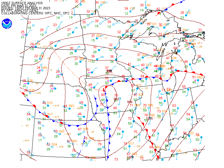
| March 31, 2023 Afternoon Surface Analysis |
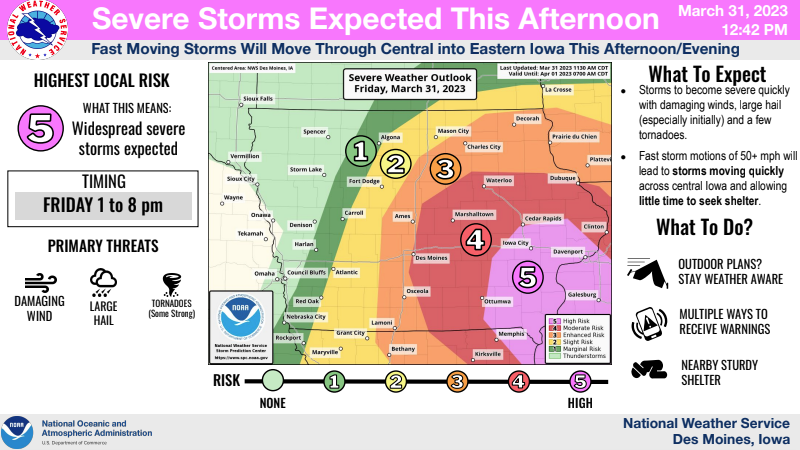
March 31, 2023 Severe Weather Outlook |
Surveyed Tornadoes
|
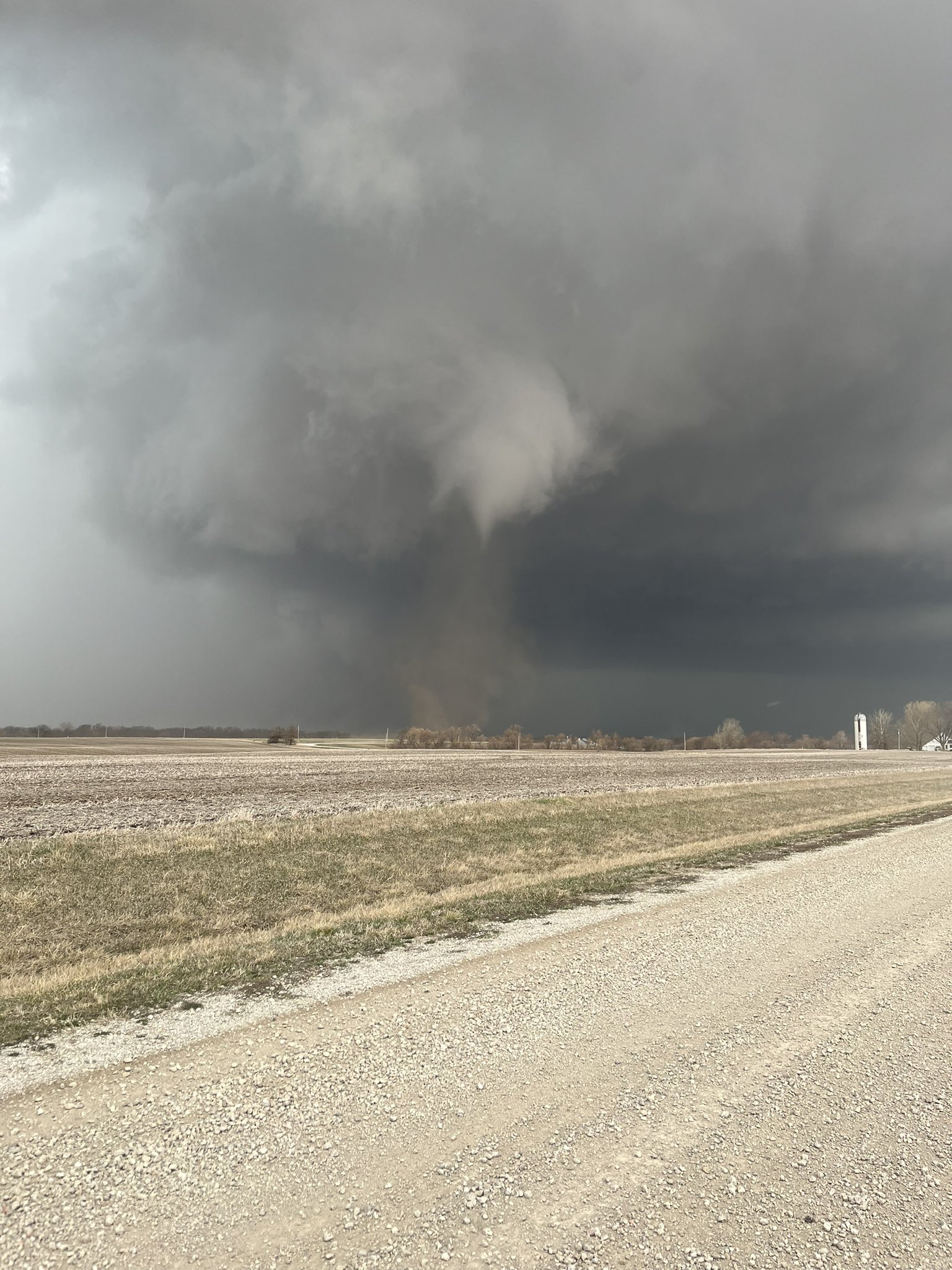
Tornado - Northeast Wapello County
Track Map 
Track Map & Downloadable KMZ File Available Soon |
||||||||||||||||
The Enhanced Fujita (EF) Scale classifies tornadoes into the following categories:
| EF0 Weak 65-85 mph |
EF1 Moderate 86-110 mph |
EF2 Significant 111-135 mph |
EF3 Severe 136-165 mph |
EF4 Extreme 166-200 mph |
EF5 Catastrophic 200+ mph |
 |
|||||
Photos & Video
 |
 |
|
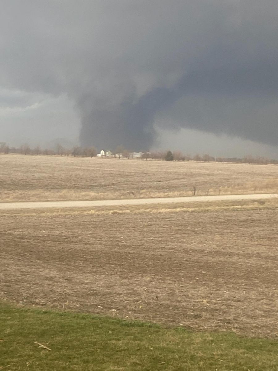
Initial tornado touch down northeast of Ottumwa. Photo Credit: Noah Emmert
|
Tornado in northeast Wapello County. Photo Credit: Wapello Sheriff / EM |
 |
 |
|
Wall cloud near Melcher-Dallas. Photo Credit: Adam Orgler |
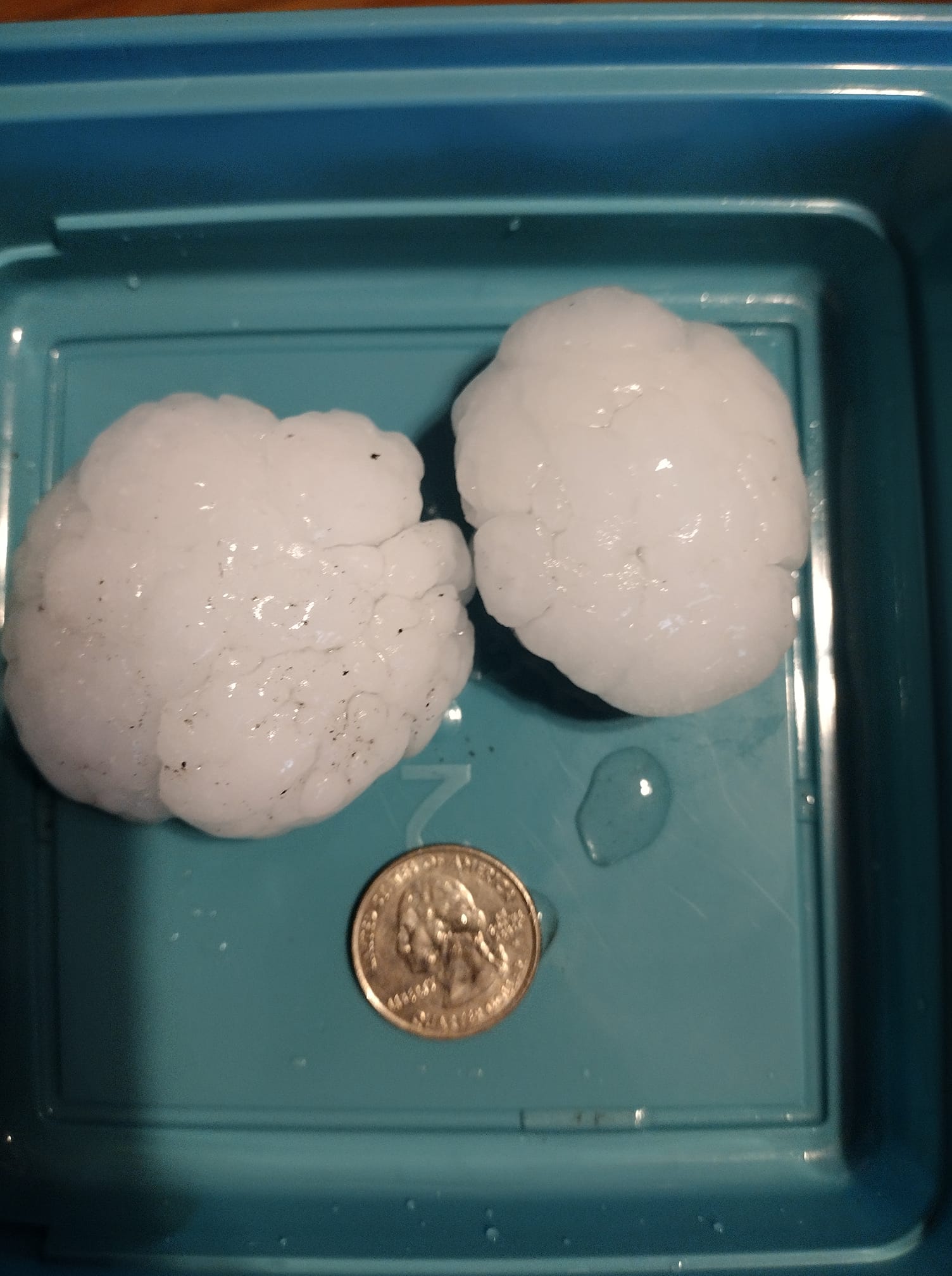
Large Hail in Centerville. Photo Credit: Frances Pineda |
Radar
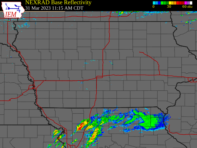 |
| Radar animation from late Friday morning through early Friday evening. Courtesy Iowa Environment Mesonet (https://mesonet.agron.iastate.edu/) |
Storm Reports
Interactive List


PRELIMINARY LOCAL STORM REPORT...SUMMARY
NATIONAL WEATHER SERVICE DES MOINES IA
1044 PM CDT FRI MAR 31 2023

..TIME...   ...EVENT...      ...CITY LOCATION...     ...LAT.LON...
..DATE...   ....MAG....      ..COUNTY LOCATION..ST.. ...SOURCE....
            ..REMARKS..

1240 PM     HAIL             5 S MOUNT AYR           40.64N 94.24W
03/31/2023  E1.75 INCH       RINGGOLD           IA   BROADCAST MEDIA

            RELAYED BY WHO-TV13 IN DES MOINES.

1243 PM     HAIL             MOUNT AYR               40.71N 94.24W
03/31/2023  E0.25 INCH       RINGGOLD           IA   TRAINED SPOTTER

            PEA-SIZED HAIL.

1249 PM     HAIL             1 ESE OSCEOLA           41.03N 93.76W
03/31/2023  E1.00 INCH       CLARKE             IA   TRAINED SPOTTER


0150 PM     HAIL             LUCAS                   41.03N 93.46W
03/31/2023  E1.75 INCH       LUCAS              IA   EMERGENCY MNGR

            RELAYED BY KNIA/KRLS RADIO.

0153 PM     HAIL             2 W MURRAY              41.04N 93.98W
03/31/2023  E1.75 INCH       CLARKE             IA   TRAINED SPOTTER


0159 PM     TSTM WND DMG     2 W MURRAY              41.04N 93.98W
03/31/2023                   CLARKE             IA   PUBLIC

            DELAYED REPORT. ONE-INCH TREE LIMBS BROKEN.
            SHINGLES BLOWN OFF.

0159 PM     HAIL             2 W MURRAY              41.04N 93.98W
03/31/2023  U1.75 INCH       CLARKE             IA   PUBLIC

            REPORT FROM MPING: GOLF BALL (1.75 IN.).

0229 PM     HAIL             2 ENE WOODBURN          41.03N 93.56W
03/31/2023  E1.50 INCH       CLARKE             IA   COUNTY OFFICIAL

            CLARKE COUNTY EMA FROM CONSERVATION ON
            HIGHWAY 34 ON THE LUCAS/CLARKE COUNTY LINE.
            TIME ESTIMATED FROM RADAR.

0235 PM     HAIL             MELBOURNE               41.94N 93.11W
03/31/2023  E1.75 INCH       MARSHALL           IA   TRAINED SPOTTER


0238 PM     HAIL             SLATER                  41.88N 93.69W
03/31/2023  U0.75 INCH       STORY              IA   PUBLIC

            REPORT FROM MPING: DIME (0.75 IN.).

0243 PM     HAIL             LACONA                  41.19N 93.38W
03/31/2023  E1.00 INCH       WARREN             IA   EMERGENCY MNGR


0243 PM     HAIL             MILO                    41.29N 93.44W
03/31/2023  E0.70 INCH       WARREN             IA   EMERGENCY MNGR


0247 PM     HAIL             2 NE NAPIER             42.00N 93.70W
03/31/2023  E1.00 INCH       STORY              IA   PUBLIC

            VIA EMAIL. TIME ESTIMATED FROM RADAR.

0247 PM     HAIL             3 WSW KELLEY            41.93N 93.72W
03/31/2023  E1.00 INCH       BOONE              IA   PUBLIC

            ESTIMATED 50 MPH GUSTS.

0249 PM     HAIL             1 SW AMES               42.01N 93.64W
03/31/2023  U0.75 INCH       STORY              IA   PUBLIC

            REPORT FROM MPING: DIME (0.75 IN.).

0250 PM     HAIL             3 WNW AMES              42.03N 93.68W
03/31/2023  E1.00 INCH       STORY              IA   PUBLIC

            HAIL STARTED ABOUT 2:50PM AND LASTED UNTIL
            2:54PM. LARGEST HAILSTONES WERE ALMOST 1
            INCH IN DIAMETER. ACCUMULATED IN DRIFTS DUE
            TO STRONG WINDS FROM THE SOUTH. ALSO
            ACCUMULATED ON FLAT SURFACES.

0250 PM     HAIL             3 NW AMES               42.05N 93.66W
03/31/2023  E1.00 INCH       STORY              IA   TRAINED SPOTTER


0250 PM     HAIL             2 W AMES                42.02N 93.67W
03/31/2023  E1.75 INCH       STORY              IA   TRAINED SPOTTER

            GOLF BALL SIZED HAIL COVERING THE GROUND.

0252 PM     HAIL             1 WSW AMES              42.02N 93.64W
03/31/2023  M1.25 INCH       STORY              IA   TRAINED SPOTTER


0252 PM     HAIL             GILBERT                 42.11N 93.65W
03/31/2023  E0.25 INCH       STORY              IA   PUBLIC

            ESTIMATED 50 MPH WINDS.

0252 PM     HAIL             1 SW AMES               42.01N 93.64W
03/31/2023  U1.00 INCH       STORY              IA   PUBLIC

            REPORT FROM MPING: QUARTER (1.00 IN.).

0253 PM     HAIL             4 N NAPIER              42.04N 93.71W
03/31/2023  E1.00 INCH       BOONE              IA   PUBLIC

            VERY STRONG WINDS.

0253 PM     HAIL             3 NW AMES               42.06N 93.65W
03/31/2023  U0.50 INCH       STORY              IA   PUBLIC

            REPORT FROM MPING: HALF-INCH (0.50 IN.).

0253 PM     HAIL             2 W AMES                42.02N 93.67W
03/31/2023  U1.00 INCH       STORY              IA   PUBLIC

            REPORT FROM MPING: QUARTER (1.00 IN.).

0254 PM     HAIL             1 ENE CENTERVILLE       40.73N 92.87W
03/31/2023  E2.25 INCH       APPANOOSE          IA   TRAINED SPOTTER


0255 PM     NON-TSTM WND GST 3 WSW PERRY             41.83N 94.16W
03/31/2023  M58 MPH          DALLAS             IA   AWOS


0255 PM     HAIL             2 W MYSTIC              40.78N 92.98W
03/31/2023  E1.00 INCH       APPANOOSE          IA   TRAINED SPOTTER


0255 PM     HAIL             CENTERVILLE             40.73N 92.87W
03/31/2023  E2.50 INCH       APPANOOSE          IA   TRAINED SPOTTER


0255 PM     HAIL             2 W AMES                42.02N 93.67W
03/31/2023  U1.00 INCH       STORY              IA   PUBLIC

            REPORT FROM MPING: QUARTER (1.00 IN.).

0255 PM     HAIL             3 NW AMES               42.06N 93.65W
03/31/2023  U0.75 INCH       STORY              IA   PUBLIC

            REPORT FROM MPING: DIME (0.75 IN.).

0256 PM     HAIL             3 NNE NAPIER            42.02N 93.69W
03/31/2023  M1.25 INCH       STORY              IA   NWS EMPLOYEE

            SOME SIDING DAMAGE.

0256 PM     HAIL             CENTERVILLE             40.73N 92.87W
03/31/2023  E2.75 INCH       APPANOOSE          IA   LAW ENFORCEMENT


0257 PM     HAIL             1 W AMES                42.03N 93.65W
03/31/2023  U1.00 INCH       STORY              IA   PUBLIC

            REPORT FROM MPING: QUARTER (1.00 IN.).

0300 PM     HAIL             GILBERT                 42.11N 93.65W
03/31/2023  E1.00 INCH       STORY              IA   TRAINED SPOTTER


0301 PM     HAIL             1 S STORY CITY          42.17N 93.59W
03/31/2023  E1.00 INCH       STORY              IA   EMERGENCY MNGR


0302 PM     HAIL             3 SW MORAVIA            40.86N 92.86W
03/31/2023  E1.00 INCH       APPANOOSE          IA   TRAINED SPOTTER


0305 PM     HAIL             CENTERVILLE             40.73N 92.87W
03/31/2023  E2.50 INCH       APPANOOSE          IA   TRAINED SPOTTER


0308 PM     HAIL             GILMAN                  41.88N 92.79W
03/31/2023  E1.75 INCH       MARSHALL           IA   TRAINED SPOTTER

            VIA PHONE.

0308 PM     HAIL             KNOXVILLE               41.32N 93.10W
03/31/2023  E1.25 INCH       MARION             IA   TRAINED SPOTTER


0309 PM     HAIL             1 NW KNOXVILLE          41.33N 93.12W
03/31/2023  U1.00 INCH       MARION             IA   PUBLIC

            REPORT FROM MPING: QUARTER (1.00 IN.).

0319 PM     HAIL             4 E LAKE RED ROCK       41.41N 93.02W
03/31/2023  U1.50 INCH       MARION             IA   PUBLIC

            REPORT FROM MPING: PING PONG BALL (1.50
            IN.).

0320 PM     FUNNEL CLOUD     8 SSW OTTUMWA           40.93N 92.50W
03/31/2023                   WAPELLO            IA   STORM CHASER

            CHASER REPORT OF FUNNEL CLOUD AND ROTATING
            WALL CLOUD SW OF HIS LOCATION.

0322 PM     HAIL             KNOXVILLE               41.32N 93.10W
03/31/2023  M1.00 INCH       MARION             IA   PUBLIC

            IMAGE SUBMITTED VIA SOCIAL MEDIA.

0323 PM     HAIL             PELLA                   41.41N 92.92W
03/31/2023  E1.50 INCH       MARION             IA   BROADCAST MEDIA

            VIA KNIA/KRLS.

0331 PM     NON-TSTM WND GST 2 ENE LAMONI            40.63N 93.90W
03/31/2023  E61 MPH          DECATUR            IA   ASOS


0335 PM     HAIL             5 S MASON CITY          43.07N 93.20W
03/31/2023  E0.88 INCH       CERRO GORDO        IA   TRAINED SPOTTER


0339 PM     TSTM WND GST     2 SSW OTTUMWA           41.00N 92.43W
03/31/2023  E60 MPH          WAPELLO            IA   TRAINED SPOTTER


0340 PM     NON-TSTM WND GST 2 WNW CLARION           42.74N 93.76W
03/31/2023  M54 MPH          WRIGHT             IA   AWOS

            TIME ESTIMATED.

0340 PM     TORNADO          7 N AGENCY              41.09N 92.32W
03/31/2023                   WAPELLO            IA   PUBLIC


0344 PM     HAIL             2 S MASON CITY          43.13N 93.20W
03/31/2023  E1.00 INCH       CERRO GORDO        IA   EMERGENCY MNGR


0345 PM     TORNADO          8 SE FREMONT            41.14N 92.32W
03/31/2023                   WAPELLO            IA   EMERGENCY MNGR


0349 PM     HAIL             MASON CITY              43.15N 93.20W
03/31/2023  E1.00 INCH       CERRO GORDO        IA   TRAINED SPOTTER


0355 PM     HAIL             WESLEY                  43.09N 93.99W
03/31/2023  E1.25 INCH       KOSSUTH            IA   TRAINED SPOTTER


0355 PM     HAIL             WAVERLY                 42.73N 92.48W
03/31/2023  M1.00 INCH       BREMER             IA   PUBLIC

            DELAYED REPORT. IMAGE SUBMITTED VIA SOCIAL
            MEDIA.

0357 PM     HAIL             WESLEY                  43.08N 93.99W
03/31/2023  E1.00 INCH       KOSSUTH            IA   TRAINED SPOTTER

            SPOTTER SAID HAIL WAS A LITTLE BIGGER THAN
            QUARTERS.

0358 PM     TORNADO          2 SSW MALCOM            41.67N 92.57W
03/31/2023                   POWESHIEK          IA   TRAINED SPOTTER


0359 PM     NON-TSTM WND GST 2 W MURRAY              41.04N 93.98W
03/31/2023  M55 MPH          CLARKE             IA   TRAINED SPOTTER


0401 PM     HAIL             6 NNW MALCOM            41.80N 92.59W
03/31/2023  U1.00 INCH       POWESHIEK          IA   PUBLIC


0402 PM     HAIL             1 SE OTTUMWA            41.01N 92.41W
03/31/2023  E1.00 INCH       WAPELLO            IA   TRAINED SPOTTER


0405 PM     TORNADO          3 ESE MALCOM            41.69N 92.50W
03/31/2023                   POWESHIEK          IA   PUBLIC

            PUBLIC REPORT OF TORNADO ON GROUND AND
            DEBRIS ALONG I-80 AT MILE MARKER 194.

0410 PM     TSTM WND DMG     3 ENE RUSSELL           41.00N 93.14W
03/31/2023                   LUCAS              IA   PUBLIC

            DELAYED REPORT. WIND DAMAGE TO OUTBUILDING.

0411 PM     NON-TSTM WND GST 3 S IOWA FALLS          42.47N 93.27W
03/31/2023  M61 MPH          HARDIN             IA   AWOS

            TIME ESTIMATED.

0417 PM     HAIL             GARNER                  43.10N 93.60W
03/31/2023  E1.00 INCH       HANCOCK            IA   PUBLIC


0419 PM     TSTM WND GST     1 NNE OWASA             42.45N 93.19W
03/31/2023  M56 MPH          HARDIN             IA   PUBLIC

            PERSONAL WEATHER STATION KIAIOWAF21.

0419 PM     NON-TSTM WND GST IOWA FALLS              42.52N 93.27W
03/31/2023  E60 MPH          HARDIN             IA   EMERGENCY MNGR


0421 PM     NON-TSTM WND GST 2 S AMES                41.99N 93.62W
03/31/2023  M54 MPH          STORY              IA   ASOS


0421 PM     HAIL             2 E ATTICA              41.23N 92.97W
03/31/2023  U1.00 INCH       MARION             IA   PUBLIC


0421 PM     HAIL             ATTICA                  41.23N 93.02W
03/31/2023  E1.00 INCH       MARION             IA   TRAINED SPOTTER

            CORRECTS PREVIOUS NON-TSTM WND GST REPORT
            FROM ATTICA. HAIL CAME IN THREE WAVES WITH
            LARGEST IN LAST WAVE (QUARTER SIZED).

0425 PM     TSTM WND DMG     KNOXVILLE               41.32N 93.10W
03/31/2023                   MARION             IA   BROADCAST MEDIA

            LARGE TREE BRANCH DOWN ON HOME.

0425 PM     TSTM WND GST     BUSSEY                  41.21N 92.89W
03/31/2023  E70 MPH          MARION             IA   TRAINED SPOTTER

            ESTIMATED 60-70 MPH WIND GUSTS. PEA-SIZED
            HAIL. LOST POWER/INTERNET.

0430 PM     FUNNEL CLOUD     4 E ALBION              42.11N 92.92W
03/31/2023                   MARSHALL           IA   LAW ENFORCEMENT

            MARSHALL COUNTY DISPATCH REPORT OF FUNNEL
            CLOUD OVER MARSHALLTOWN AIRPORT.

0445 PM     FUNNEL CLOUD     2 NW MARSHALLTOWN       42.06N 92.94W
03/31/2023                   MARSHALL           IA   PUBLIC

            PUBLIC REPORT OF FUNNEL CLOUD NORTH OF
            MARSHALLTOWN VETERANS HOME AT 1645 RELAYED
            TO NWS DMX FROM NWS DVN.

0456 PM     NON-TSTM WND GST 2 S AMES                41.99N 93.62W
03/31/2023  M59 MPH          STORY              IA   ASOS


0502 PM     NON-TSTM WND GST 3 WNW FREMONT           41.23N 92.49W
03/31/2023  M58 MPH          MAHASKA            IA   AWOS
 |
Media use of NWS Web News Stories is encouraged! Please acknowledge the NWS as the source of any news information accessed from this site. |
|

