Overview
|
Multiple storms developed on the afternoon of Saturday, July 11, 2020 and several of them quickly reached severe limits. The severe weather event lasted through sunset when the storms diminished in strength.
|
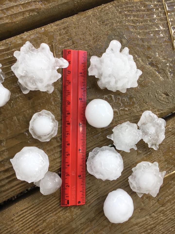 The various hail sizes that fell from a severe supercell thunderstorm in Fort Dodge on July 11th. Photo courtesy of Joe Sullivan. |
 |
 |
-NEsideFortDodge.jpg) |
|
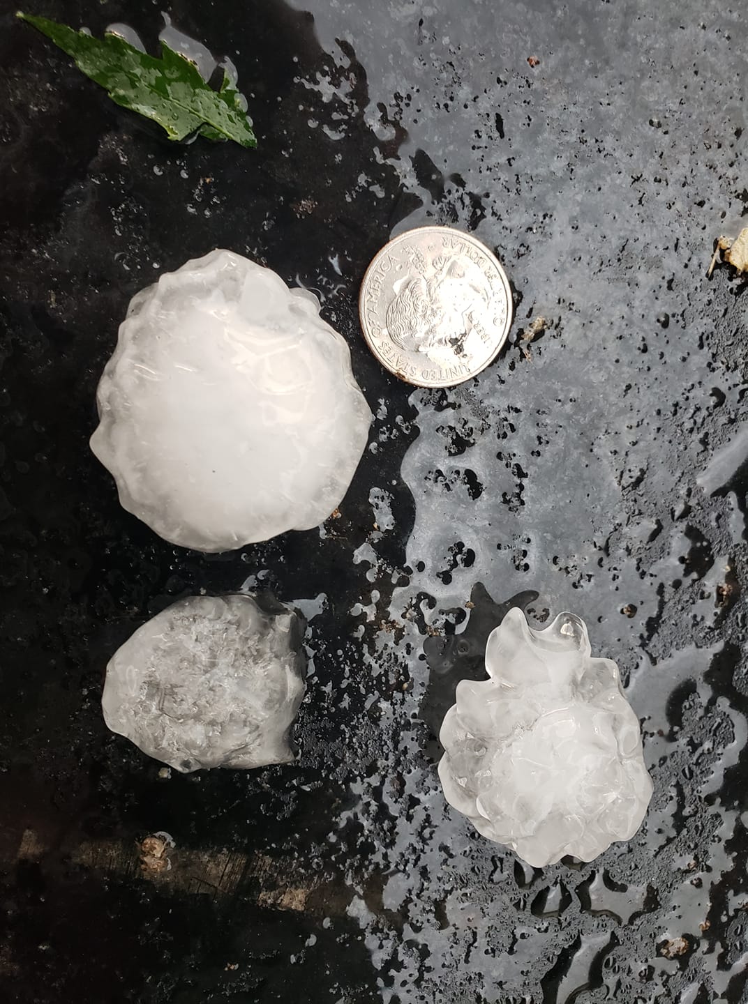
Figure 1: South of Shell Rock, Courtesy Chuck Fulks on July 11th. |
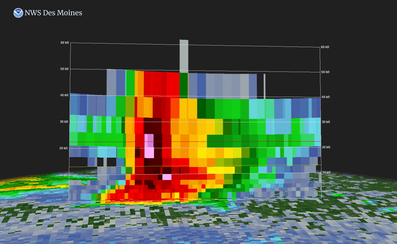
Figure 2: Radar reflectivity cross section shows the updraft as high as 50,000 feet from a storm over Randall, Iowa that produced 2” diameter hail. |
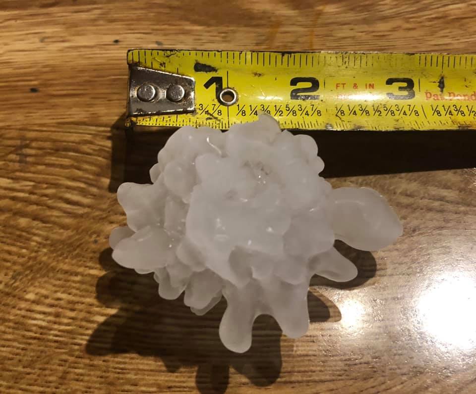
Figure 3: Another large hail photo on the northeast side of Fort Dodge. Photo courtesy of Beth Humphrey. |
Photos & Video
We received multiple photos of hail throughout the event across northern Iowa and these just a handful we received via social media and email.
 |
.jpg) |
.jpg) |
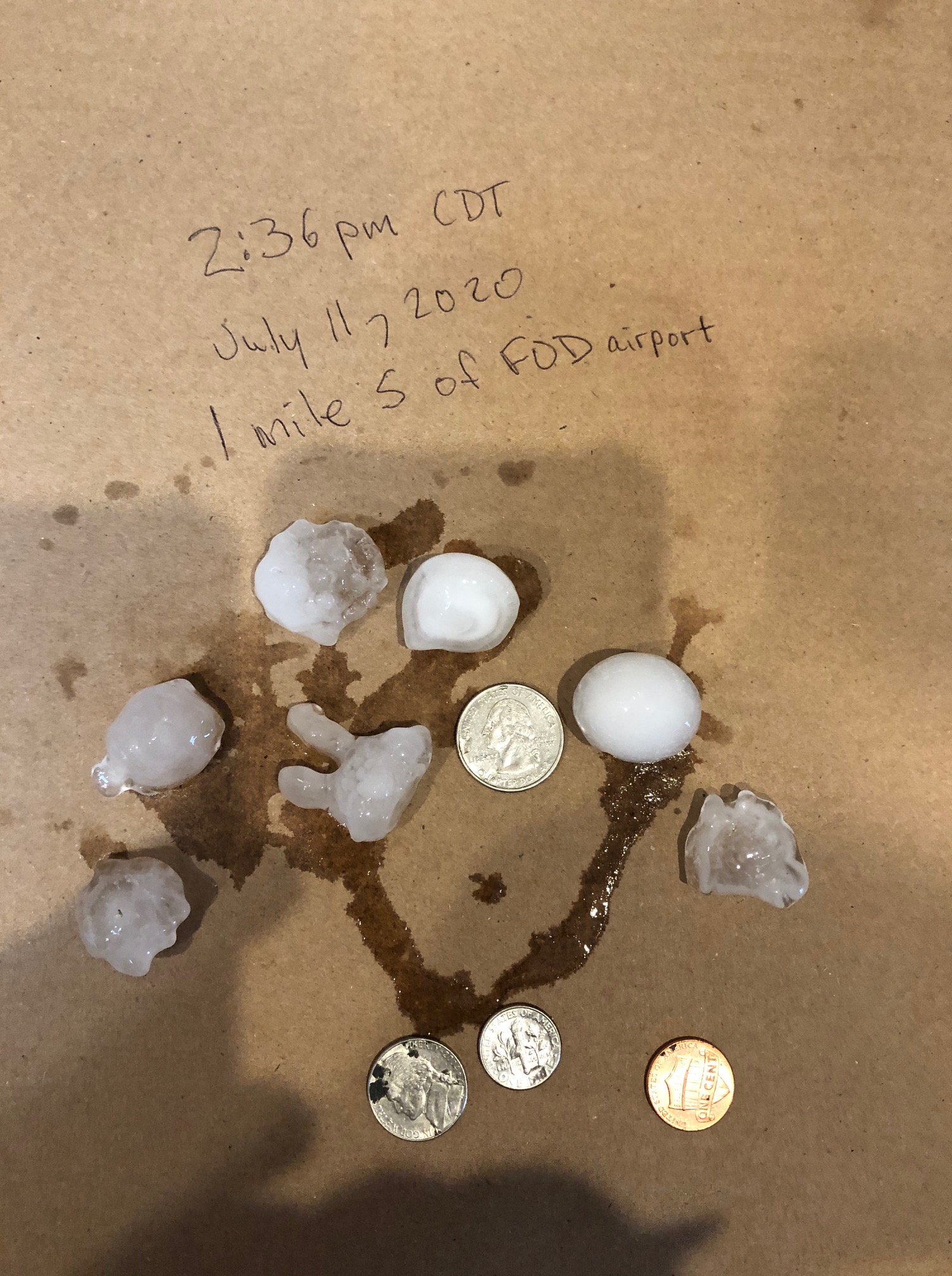 |
| McCallsburg, Iowa. Photo courtesy of Angela Sarazin | Fort Dodge, Iowa. Photo courtesy of Jennifer Marsh | Fort Dodge, Iowa. Photo courtesy of Jennifer Marsh | Near the Fort Dodge Airport. Photo courtesy of Dan Gilbert |
Header
| Caption (source) |
Caption (source) |
Caption (source) |
Caption (source) |
Header
| Caption (source) |
Caption (source) |
Caption (source) |
Caption (source) |
Header
| Caption (source) |
Caption (source) |
Caption (source) |
Caption (source) |
Radar and Satellite
Various radar captures from the event.
.gif) |
 |
 |
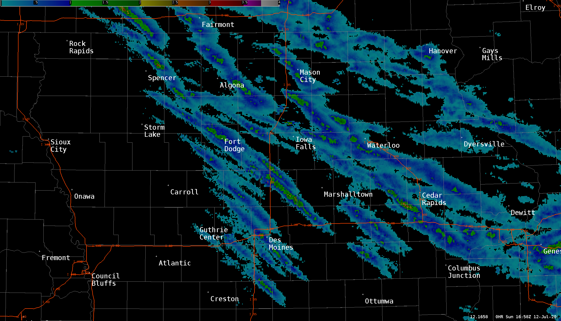 |
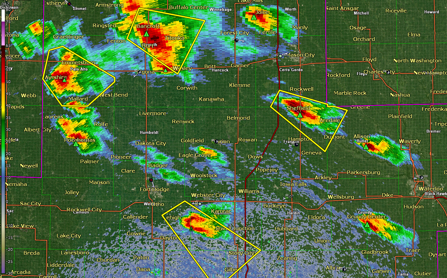
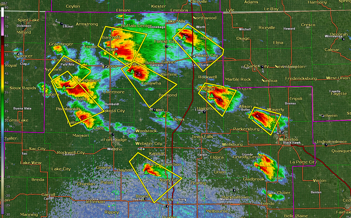
| Radar loop of the entire event. | Radar capture at 3:07 PM CT with 4 supercells producing large hail across northern Iowa. | By 3:24 PM CT, 8 Severe Thunderstorm Warnings were in effect across northern Iowa. All producing large hail. | MESH or Maximum Estimated Size of Hail for the entire event on July 11, 2020. |
 |
 |
 |
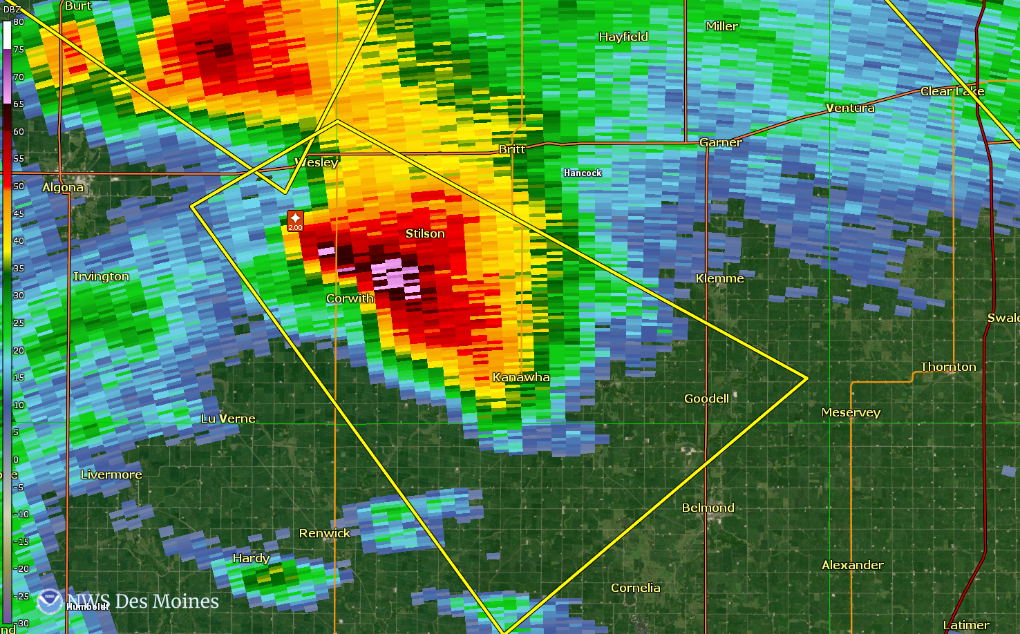 |
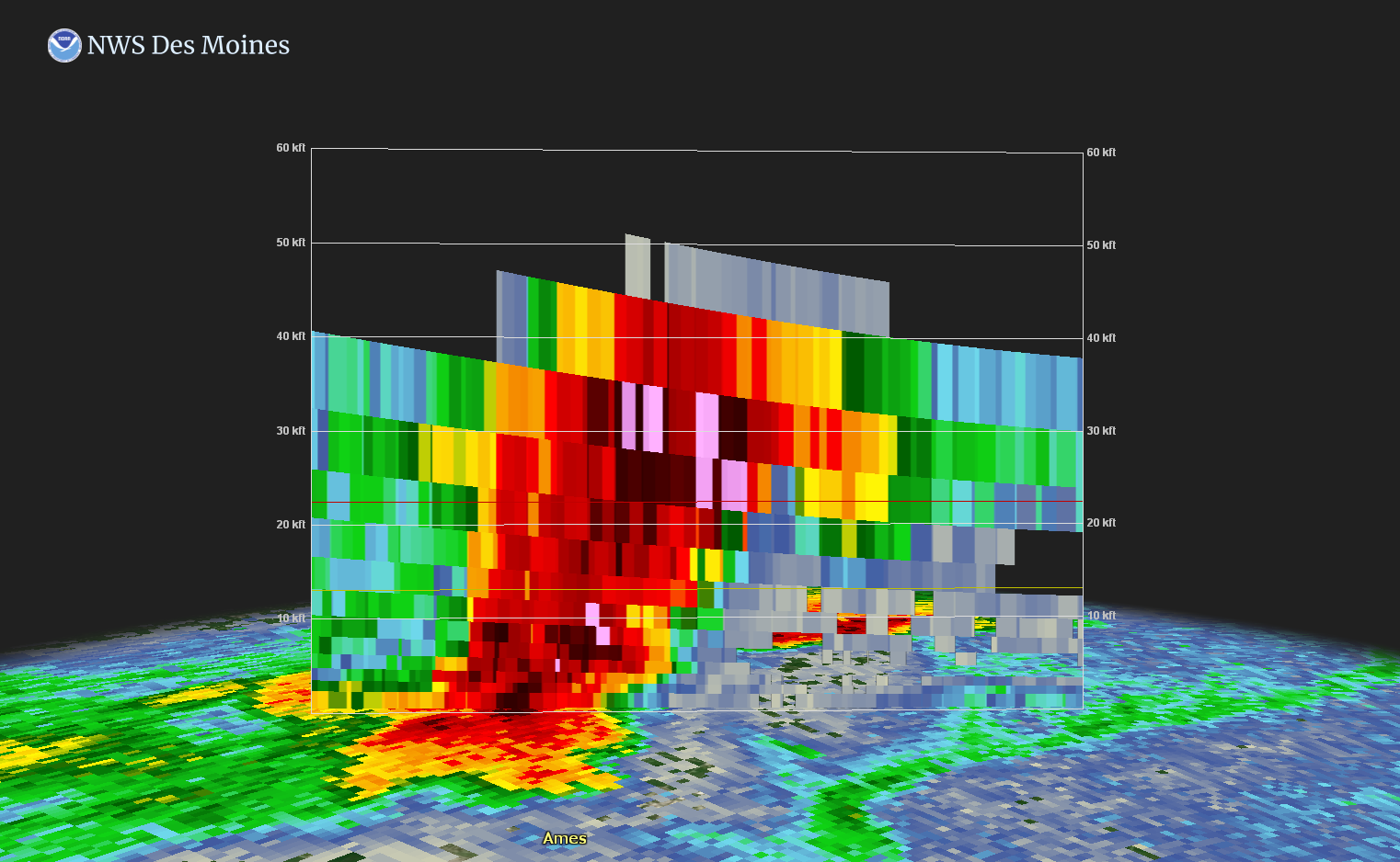
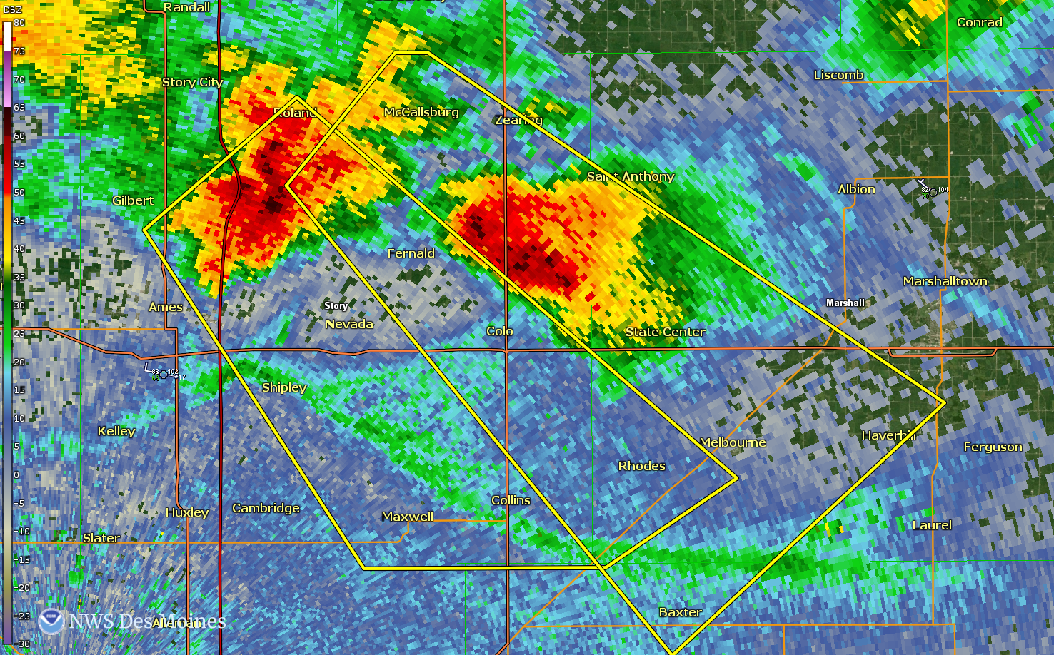
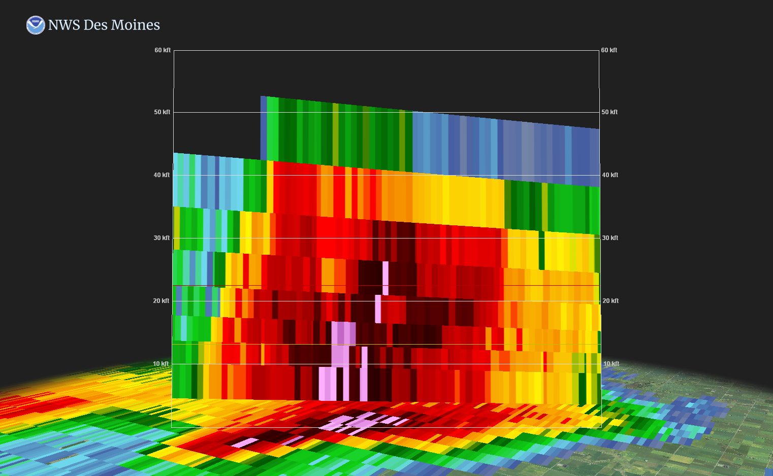
| One of the severe storms in Story County (see image to right). This one is over Nevada where the cross section shows the storm's updraft reaching 45,000 feet! | Two supercells producing very large hail at the same time in Story County...just northeast of Ames and north of Colo. | Storm over Corwith and Stilson, Iowa had a storm top of 50,000 feet viewed from this cross section. | Base reflectivity of the big storm over Corwith and Stilson, Iowa at 2029 UTC or 3:29 PM CT. |
Storm Reports
 |
 |
|
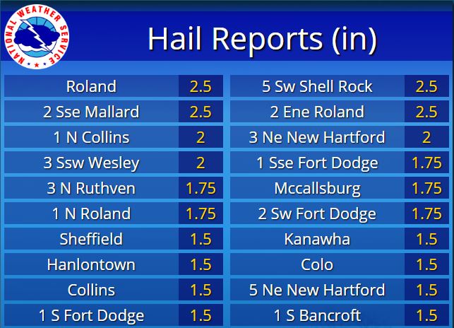
| Hail Reports (NWS) |
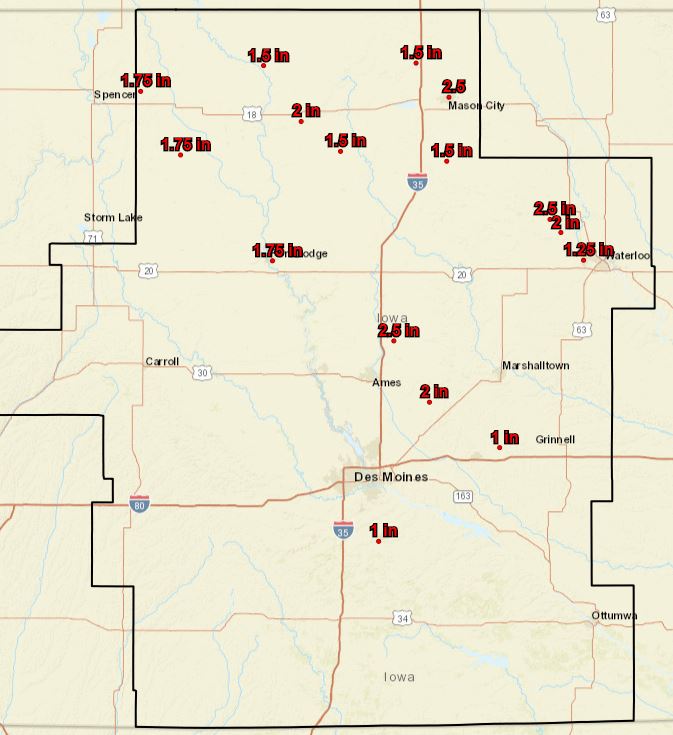
Hail Reports Map (NWS) |
PRELIMINARY LOCAL STORM REPORT...SUMMARY
NATIONAL WEATHER SERVICE DES MOINES IA
1005 PM CDT SAT JUL 11 2020

..TIME...   ...EVENT...      ...CITY LOCATION...     ...LAT.LON...
..DATE...   ....MAG....      ..COUNTY LOCATION..ST.. ...SOURCE....
            ..REMARKS..

0330 PM     HAIL             HANLONTOWN              43.29N 93.38W
07/11/2020  E1.50 INCH       WORTH              IA   BROADCAST MEDIA

            DELAYED MEDIA REPORT OF PING PONG BALL SIZED
            HAIL JUST NORTH OF HANLONTOWN AROUND 3:30PM.

0241 PM     HAIL             1 SSE FORT DODGE        42.49N 94.17W
07/11/2020  E1.75 INCH       WEBSTER            IA   TRAINED SPOTTER

            QUARTER TO GOLF BALL SIZED HAIL SE OF FORT
            DODGE.

0238 PM     HAIL             1 S FORT DODGE          42.50N 94.18W
07/11/2020  E1.50 INCH       WEBSTER            IA   TRAINED SPOTTER

            TRAINED SPOTTER REPORTS PING PONG BALL SIZED
            HAIL NEAR FORT DODGE.

0229 PM     HAIL             2 SW FORT DODGE         42.49N 94.21W
07/11/2020  M1.75 INCH       WEBSTER            IA   TRAINED SPOTTER


0227 PM     HAIL             FORT DODGE              42.51N 94.18W
07/11/2020  E1.00 INCH       WEBSTER            IA   TRAINED SPOTTER

            TRAINED SPOTTER REPORTS QUARTER SIZED HAIL
            ON THE NW SIDE OF FORT DODGE.

0215 PM     HAIL             CLARE                   42.59N 94.34W
07/11/2020  E1.00 INCH       WEBSTER            IA   PUBLIC

            REPORT VIA SOCIAL MEDIA.

0754 PM     HAIL             1 SW INDIANOLA          41.35N 93.58W
07/11/2020  M1.00 INCH       WARREN             IA   TRAINED SPOTTER


0604 PM     HAIL             3 ESE COLLINS           41.89N 93.25W
07/11/2020  M0.88 INCH       STORY              IA   PUBLIC

            REPORT VIA SOCIAL MEDIA.

0600 PM     HAIL             COLO                    42.02N 93.32W
07/11/2020  E1.50 INCH       STORY              IA   TRAINED SPOTTER

            TRAINED SPOTTER REPORTED 1.25 TO 1.5 INCH
            HAIL SE OF COLO.

0555 PM     HAIL             COLLINS                 41.90N 93.31W
07/11/2020  E1.50 INCH       STORY              IA   EMERGENCY MNGR

            DELAYED REPORT FROM EM: PING PONG BALL SIZED
            HAIL IN COLLINS AT APPROXIMATELY 1755.

0555 PM     HAIL             1 N COLLINS             41.92N 93.31W
07/11/2020  E2.00 INCH       STORY              IA   EMERGENCY MNGR

            DELAYED REPORT FROM EM:1 MILE NORTH OF
            COLLINS ON HWY 65 OF 2 INCH HAIL (LASTED 10
            MIN, DAMAGE TO SIDING).

0548 PM     HAIL             1 SE NEVADA             42.01N 93.44W
07/11/2020  E1.00 INCH       STORY              IA   LAW ENFORCEMENT

            LAW ENFORCEMENT REPORTS 1 INCH HAIL IN
            NEVADA, IA.

0535 PM     HAIL             2 ENE ROLAND            42.18N 93.46W
07/11/2020  E2.50 INCH       STORY              IA   EMERGENCY MNGR

            TRAINED SPOTTER AT 620TH AVE AND 120TH ST IN
            STORY CO REPORTED 2.5 IN HAIL AT
            APPROXIMATELY 1735.

0532 PM     HAIL             1 SW MCCALLSBURG        42.16N 93.40W
07/11/2020  E1.25 INCH       STORY              IA   TRAINED SPOTTER

            TRAINED SPOTTER REPORTED 1.25 INCH HAIL 1
            MILE SW OF MCCALLSBURG.

0532 PM     HAIL             1 NNE COLO              42.03N 93.31W
07/11/2020  E1.00 INCH       STORY              IA   PUBLIC

            TRAINED SPOTTER REPORTS QUARTER SIZE HAIL ON
            US 65 HALF WAY BETWEEN COLO AND ZEARING.

0530 PM     HAIL             MCCALLSBURG             42.17N 93.39W
07/11/2020  M1.75 INCH       STORY              IA   PUBLIC

            REPORT VIA SOCIAL MEDIA.

0521 PM     HAIL             ROLAND                  42.17N 93.50W
07/11/2020  M1.00 INCH       STORY              IA   EMERGENCY MNGR

            NICKEL TO QUARTER SIZED HAIL.

0520 PM     HAIL             ROLAND                  42.17N 93.50W
07/11/2020  E2.50 INCH       STORY              IA   BROADCAST MEDIA

            COURTESY OF KCCI. REPORT VIA SOCIAL MEDIA.

0518 PM     HAIL             1 N ROLAND              42.19N 93.50W
07/11/2020  M1.75 INCH       STORY              IA   PUBLIC

            REPORT VIA SOCIAL MEDIA.

0352 PM     HAIL             STORY CITY              42.19N 93.59W
07/11/2020  E1.50 INCH       STORY              IA   EMERGENCY MNGR

            LAW ENFORCEMENT REPORTED QUARTER TO PING
            PONG BALL SIZED HAIL IN STORY CITY. HAIL
            LASTED 1 - 2 MINUTES.

0340 PM     HAIL             5 NNW GILBERT           42.17N 93.70W
07/11/2020  E1.00 INCH       STORY              IA   TRAINED SPOTTER

            TRAINED SPOTTER REPORTED 1 INCH HAIL AT THE
            INTERSECTION OF E18 AND R38 NORTHWEST OF
            GILBERT.

0720 PM     HAIL             2 S WINDSOR HEIGHTS     41.58N 93.71W
07/11/2020  M0.75 INCH       POLK               IA   TRAINED SPOTTER


0145 PM     FUNNEL CLOUD     3 NNE PALMER            42.68N 94.58W
07/11/2020                   POCAHONTAS         IA   TRAINED SPOTTER

            MULTIPLE REPORTS VIA SOCIAL MEDIA OF A
            FUNNEL CLOUD SOUTHEAST OF POCAHONTAS AND
            SOUTHWEST OF GILMORE CITY.

0258 PM     HAIL             RUTHVEN                 43.13N 94.90W
07/11/2020  M1.00 INCH       PALO ALTO          IA   BROADCAST MEDIA

            REPORT VIA KICD.

0254 PM     HAIL             3 N RUTHVEN             43.17N 94.89W
07/11/2020  M1.75 INCH       PALO ALTO          IA   BROADCAST MEDIA

            REPORT VIA KICD. TIME ESTIMATED BY RADAR.

0324 PM     HAIL             3 SSW WESLEY            43.05N 94.01W
07/11/2020  E2.00 INCH       KOSSUTH            IA   PUBLIC


0630 PM     HAIL             1 NNW KELLOGG           41.73N 92.92W
07/11/2020  E1.00 INCH       JASPER             IA   TRAINED SPOTTER

            TRAINED SPOTTER REPORTED QUARTER SIZED HAIL
            4 MILES EAST OF NEWTON.

0611 PM     HAIL             BAXTER                  41.83N 93.15W
07/11/2020  E1.00 INCH       JASPER             IA   FIRE DEPT/RESCUE

            FIRE DEPT. REPORTS QUARTER SIZE HAIL IN
            BAXTER, IA.

0439 PM     HAIL             4 SSW PARKERSBURG       42.52N 92.81W
07/11/2020  M1.00 INCH       GRUNDY             IA   TRAINED SPOTTER


0315 PM     HAIL             SHEFFIELD               42.89N 93.21W
07/11/2020  E1.50 INCH       FRANKLIN           IA   PUBLIC

            SOCIAL MEDIA REPORT OF PING PONG BALL SIZED
            HAIL IN SHEFFIELD, IA.

0402 PM     HAIL             1 NNW MASON CITY        43.17N 93.20W
07/11/2020  E1.00 INCH       CERRO GORDO        IA   TRAINED SPOTTER

            TRAINED SPOTTER REPORTS 1 INCH HAIL ONE MILE
            NORTH OF MASON CITY, IA.

0354 PM     TSTM WND GST     3 NE CLEAR LAKE         43.16N 93.33W
07/11/2020  M62 MPH          CERRO GORDO        IA   ASOS


0323 PM     HEAVY RAIN       MASON CITY              43.15N 93.20W
07/11/2020  E2.50 INCH       CERRO GORDO        IA   BROADCAST MEDIA

            DELAYED PUBLIC REPORT OF 2.5 INCHES OF RAIN
            IN MASON CITY, IA AT 3:23 PM.

0351 PM     HAIL             3 NE NEW HARTFORD       42.61N 92.58W
07/11/2020  M2.00 INCH       BUTLER             IA   BROADCAST MEDIA

            COURTESY OF KWWL. REPORT VIA SOCIAL MEDIA
            AND TIME AND LOCATION ESTIMATED BY RADAR.

0346 PM     HAIL             5 NE NEW HARTFORD       42.62N 92.56W
07/11/2020  E1.50 INCH       BUTLER             IA   PUBLIC

            REPORT VIA SOCIAL MEDIA.

0334 PM     HAIL             5 SW SHELL ROCK         42.66N 92.64W
07/11/2020  M2.50 INCH       BUTLER             IA   PUBLIC

            REPORT VIA SOCIAL MEDIA. TIME ESTIMATED AND
            LOCATION ESTIMATED BY RADAR.

0326 PM     HAIL             4 SSW CLARKSVILLE       42.73N 92.70W
07/11/2020  E1.00 INCH       BUTLER             IA   NWS EMPLOYEE

            NWS EMPLOYEE REPORTS QUARTER SIZED HAIL SW
            OF CLARKSVILLE, IA.

0431 PM     HAIL             2 S CEDAR FALLS         42.49N 92.46W
07/11/2020  M1.25 INCH       BLACK HAWK         IA   PUBLIC


0424 PM     HAIL             3 SW CEDAR FALLS        42.48N 92.50W
07/11/2020  M1.00 INCH       BLACK HAWK         IA   TRAINED SPOTTER


0420 PM     HAIL             2 SSW CEDAR FALLS       42.49N 92.47W
07/11/2020  M1.00 INCH       BLACK HAWK         IA   BROADCAST MEDIA

            COURTESY OF KWWL. REPORT VIA SOCIAL MEDIA.

0405 PM     HAIL             2 S CEDAR FALLS         42.49N 92.46W
07/11/2020  E0.70 INCH       BLACK HAWK         IA   PUBLIC


0358 PM     HAIL             4 NNW CEDAR FALLS       42.57N 92.49W
07/11/2020  M0.88 INCH       BLACK HAWK         IA   BROADCAST MEDIA

            COURTESY OF KWWL. REPORT VIA SOCIAL MEDIA.
            TIME AND LOCATION ESTIMATED BY RADAR.

0354 PM     HAIL             4 WSW JANESVILLE        42.63N 92.54W
07/11/2020  M1.00 INCH       BLACK HAWK         IA   BROADCAST MEDIA

            TIME AND LOCATION ESTIMATED BY RADAR.
            COURTESY OF KWWL.
Environment
Insert synoptic summary.
| Figure 1: Caption | Figure 2: Caption | Figure 3: Caption |
Near-storm environment summary.
| Figure 4: Caption | Figure 5: Caption | Figure 6: Caption |
Additional environmental data.
| Figure 7: Caption | Figure 8: Caption | Figure 9: Caption |
 |
Media use of NWS Web News Stories is encouraged! Please acknowledge the NWS as the source of any news information accessed from this site. |
|

