Overview
For current river observations, forecasts, and warnings, please visit www.weather.gov/desmoines/water
Heavy rain fell over portions of northern Iowa, especially northwestern Iowa up into portions of southwest Minnesota and southeastern South Dakota later on June 20 through early on June 21. This rainfall caused flash flooding in portions of northwest Iowa and also aided in saturating the soil. As another round of heavy rain fell later on June 21 into the night and morning of June 22, this rainfall led to renewed flash flooding. This rainfall made its way into streams and rivers resulting in significant and record river flooding in northwest Iowa including the West Fork of the Des Moines River. Much of this page is completed, though additional photos will be added. River stages are still preliminary and subject to change! Summaries from other NWS Offices: Sioux Falls, SD | Twin Cities, MN | La Crosse, WI
Page last updated: August 25, 2024 345 AM
|
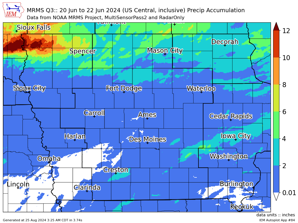
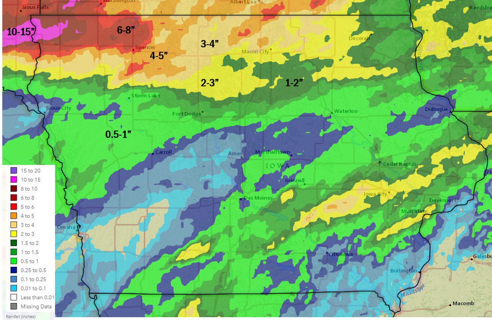 June 20-22, 2024 3 day Multi-sensor Estimated Rainfall |
 |
 |
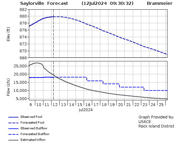 |
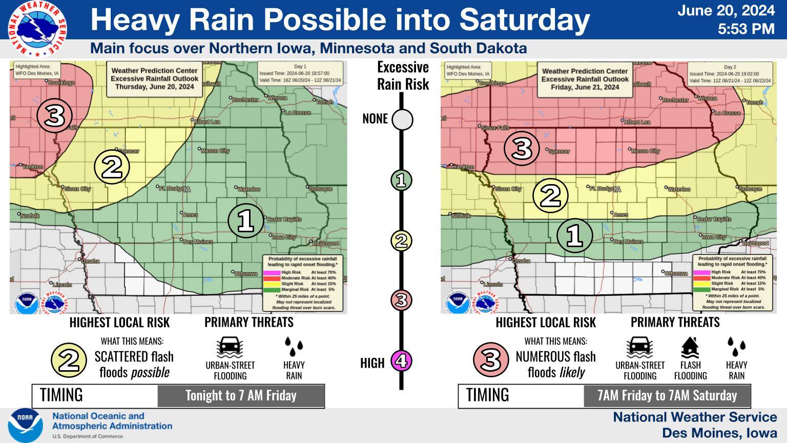
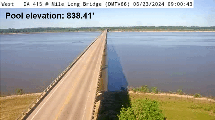
| Heavy rain messaging from the early evening of 6-20-24. | Iowa DOT webcam on Highway 415/Mile Long Bridge showing Saylorville Reservoir's pool elevation rising from 838.41' on June 23, 2024 to a max of 878.89' on July 12, 2024. Images are from the Iowa DOT. | Saylorville forecast from the U.S. Army Corps of Engineers showing the lake pool elevation for Saylorville Lake cresting around 880 feet. Graphic as of July 12, 2024, courtesy of the USACE Rock Island District. |
Flooding
Moderate to major river flooding was widespread as a result of the heavy rainfall with multiple locations reaching record high river stages. Unfortunately, sporadic data outages at some gages led to incomplete hydrograph traces. We are working with local officials to determine the peak crest at these locations.
 |
|
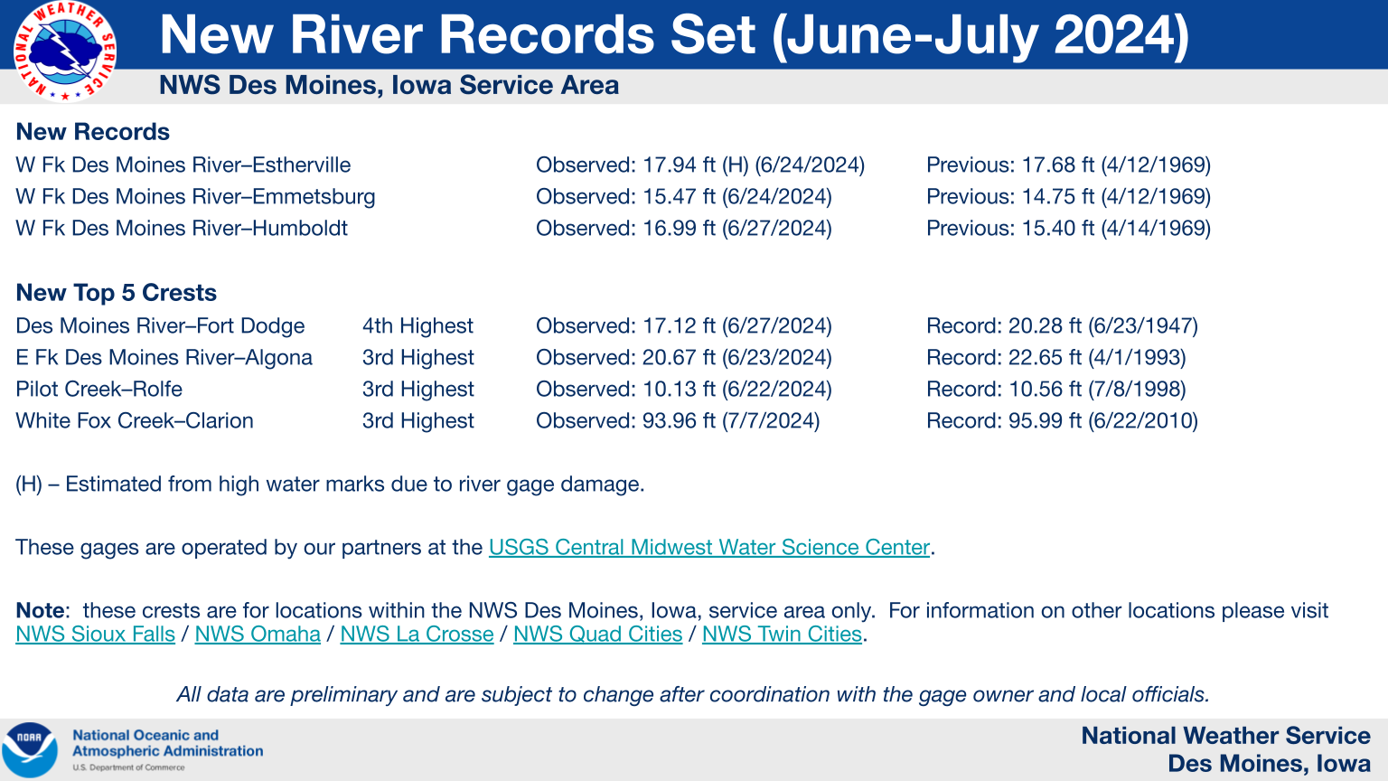
New River Flood Records *All data preliminary and subject to change. Estherville record stage is estimated. |
Hydrographs
 |
 |
 |
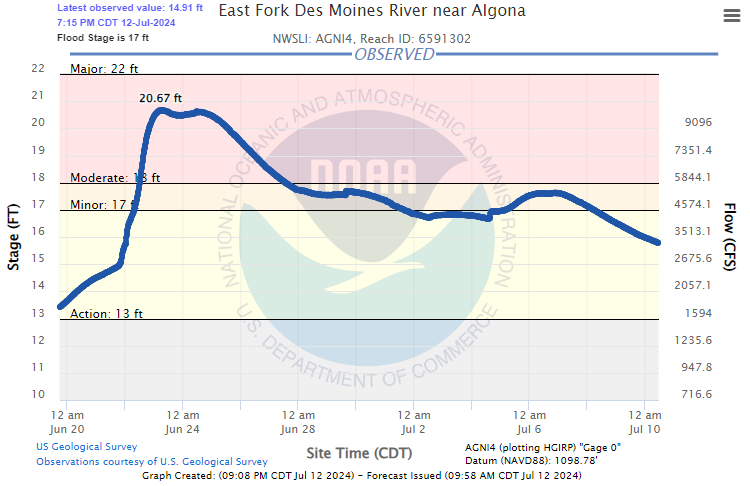 |
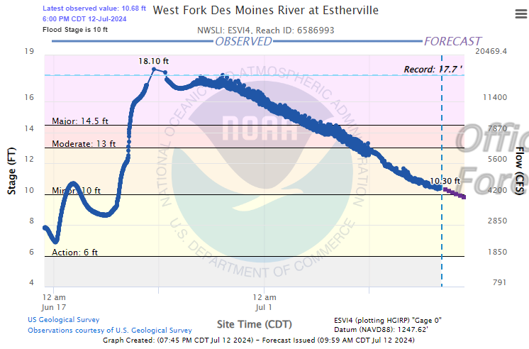
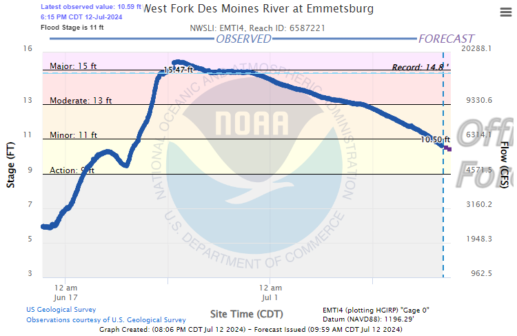
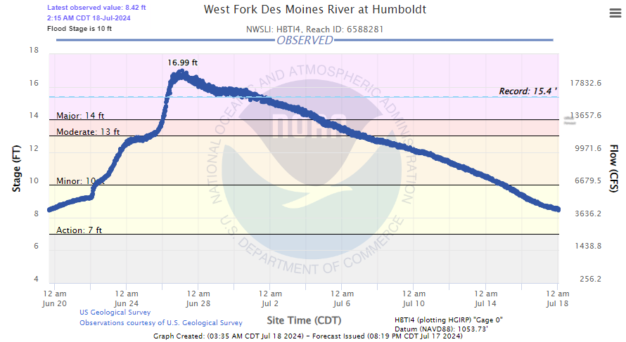
| West Fork Des Moines River at Estherville (ESVI4). New record crest on 6-24-24 estimated to be 17.94 ft from high water mark. | West Fork Des Moines River at Emmetsburg (EMTI4). New record crest on 6-24-24 observed to be 15.47 ft. | West Fork Des Moines River at Humboldt (HBTI4). New record crest on 6-27-24 observed to be 16.99 ft. | East Fork Des Moines River near Algona (AGNI4). Crest on 6-23-24 observed to be 20.67 ft, which ranks 3rd in historic crests for the site. |
 |
 |
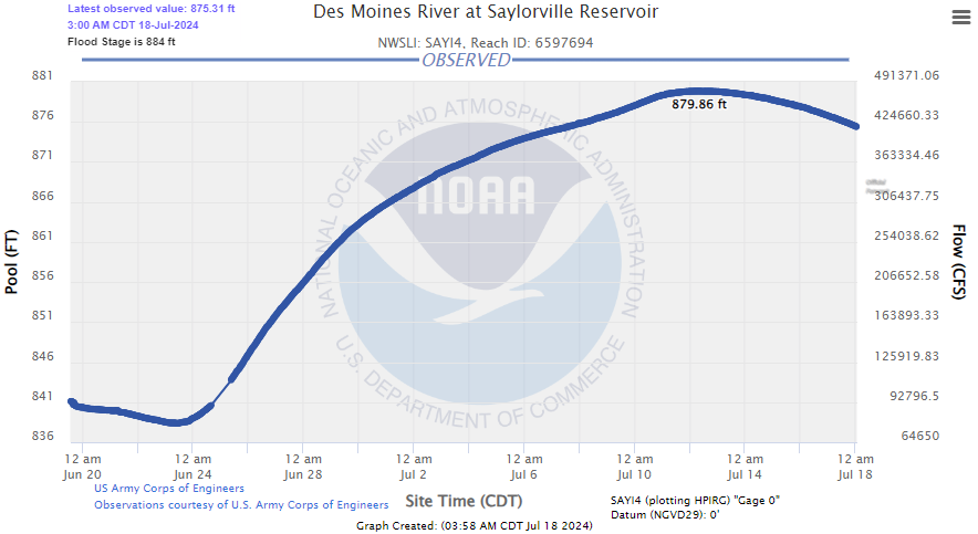 |
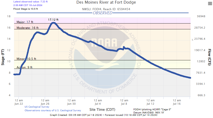
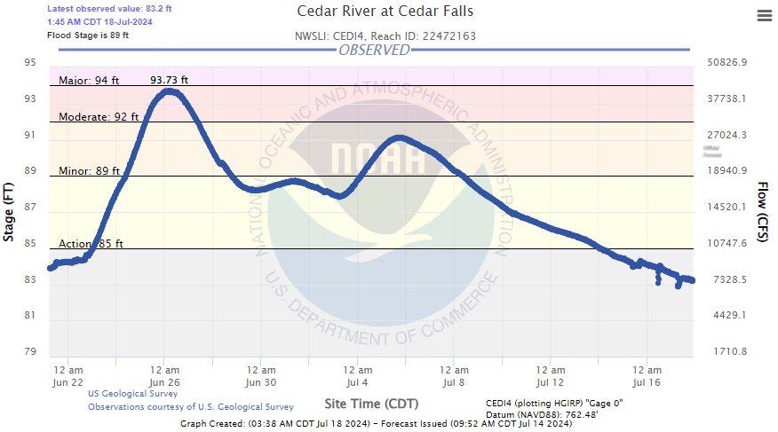
| Des Moines River at Fort Dodge (FODI4). Preliminary crest on 6-27-24 of 17.12 ft. This is the 4th highest crest on record. | Cedar River at Cedar Falls (CEDI4). Preliminary crest on 6-26-24 of 93.73 ft. This is the 9th highest crest on record. | Saylorville Reservoir (SAYI4) reached 879.86 ft on July 12, 2024. This is the 10th highest crest on record. |
Photos
 |
 |
 |
 |
| View of NWS Des Moines Radar from east side of Saylorville Lake overlooking flooded beach and lower parking area at Cherry Glen. (source: NWS Des Moines Staff) |
Algona's North Park flooded by the East Fork Des Moines River (Credit: Iowa Wing of the Civil Air Patrol) |
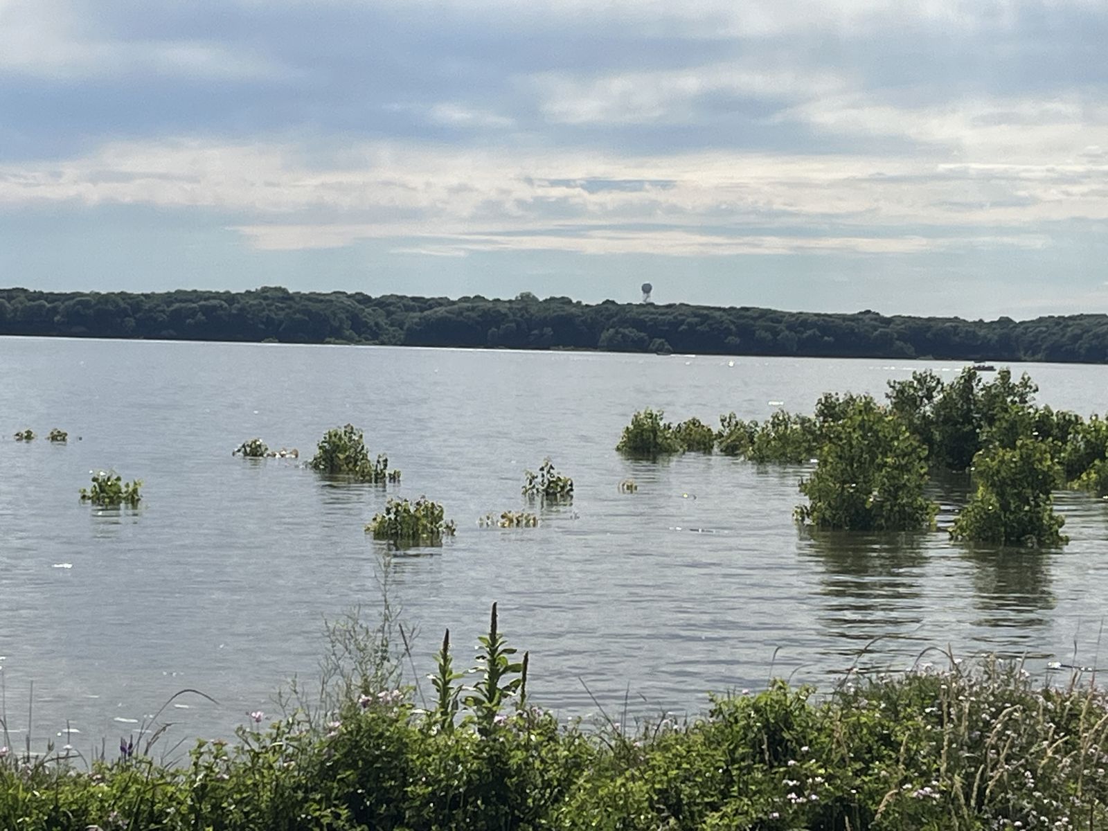
Robert Mulrony Recreation Wildlife Area southeast of Emmetsburg flooded by the West Fork Des Moines River (Credit: Iowa Wing of the Civil Air Patrol) |
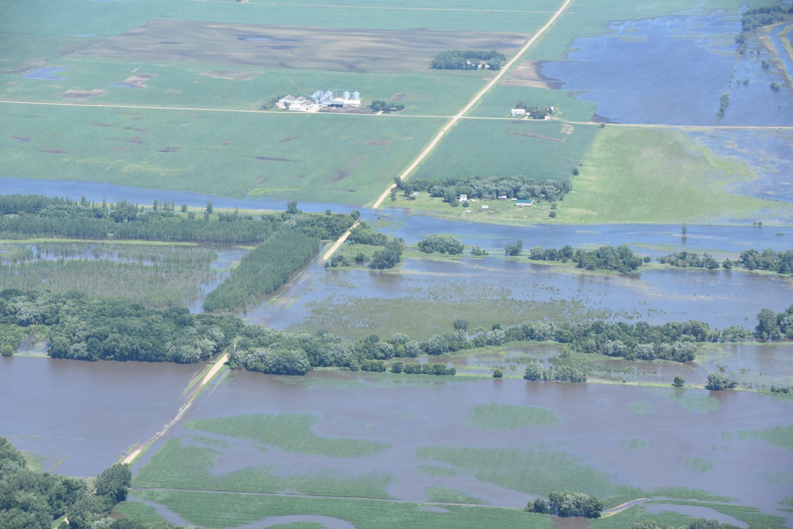
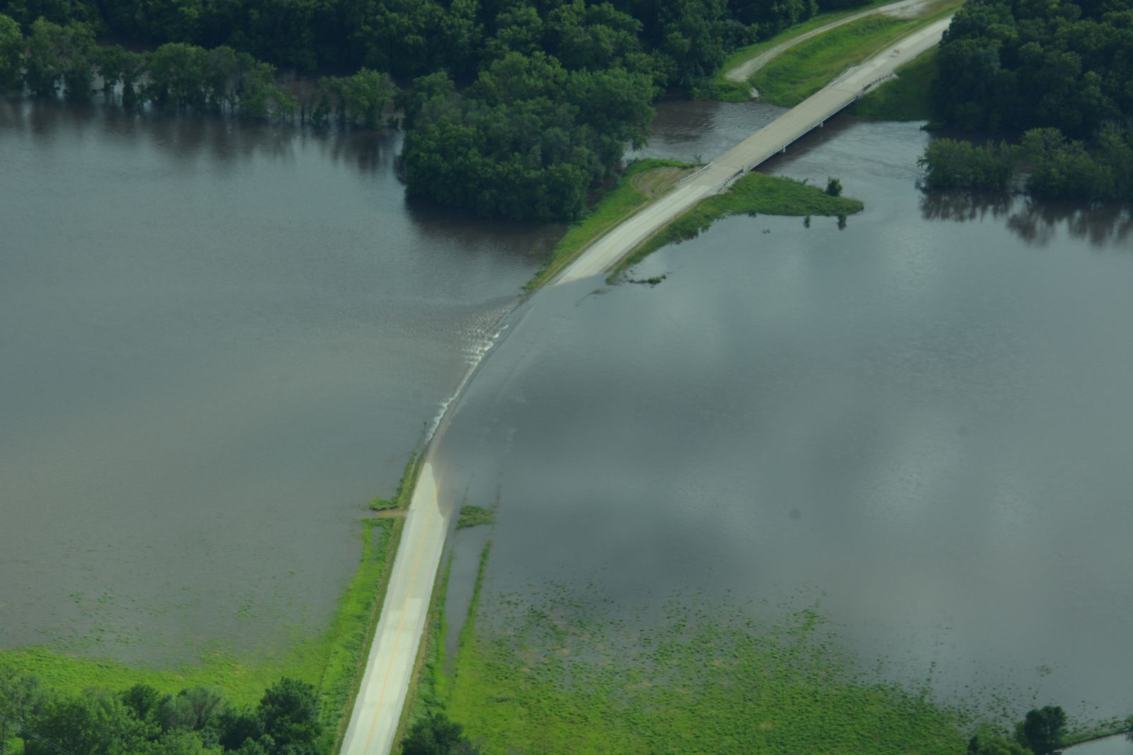
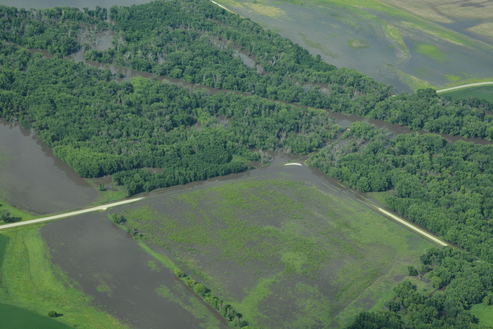
Water flowing over County Road C26 west of Hardy (Credit: Iowa Wing of the Civil Air Patrol) |
 |
 |
 |
 |
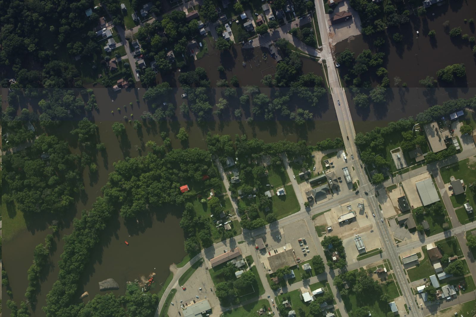
| Top down view of flooding along the West Fork Des Moines River in Estherville with Highway 9 along the right side of the photo with west (top) to east (bottom). (Credit: Iowa Wing of the Civil Air Patrol) |
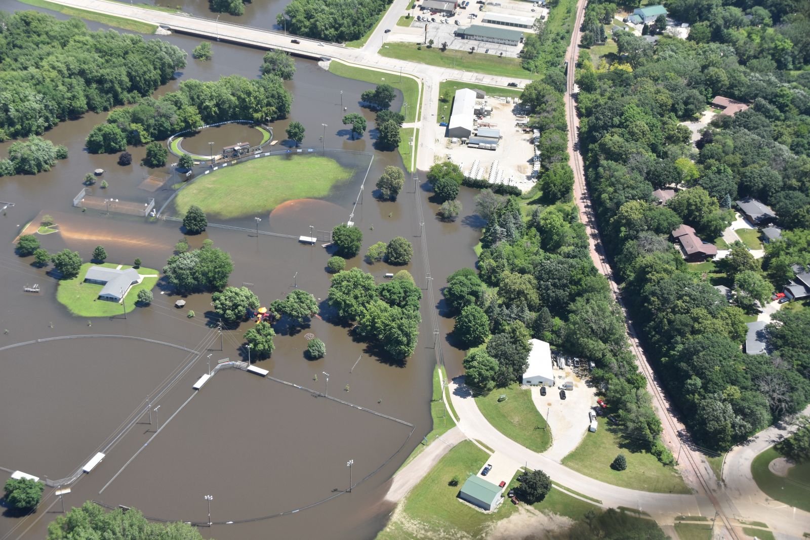
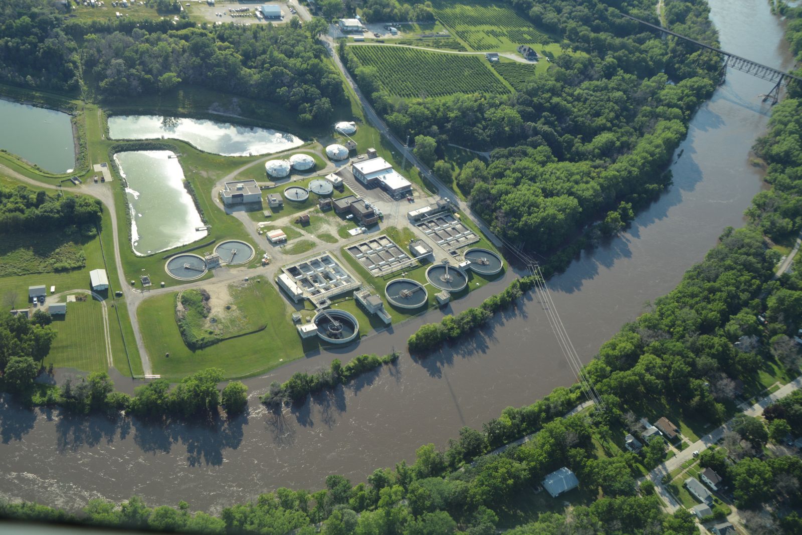
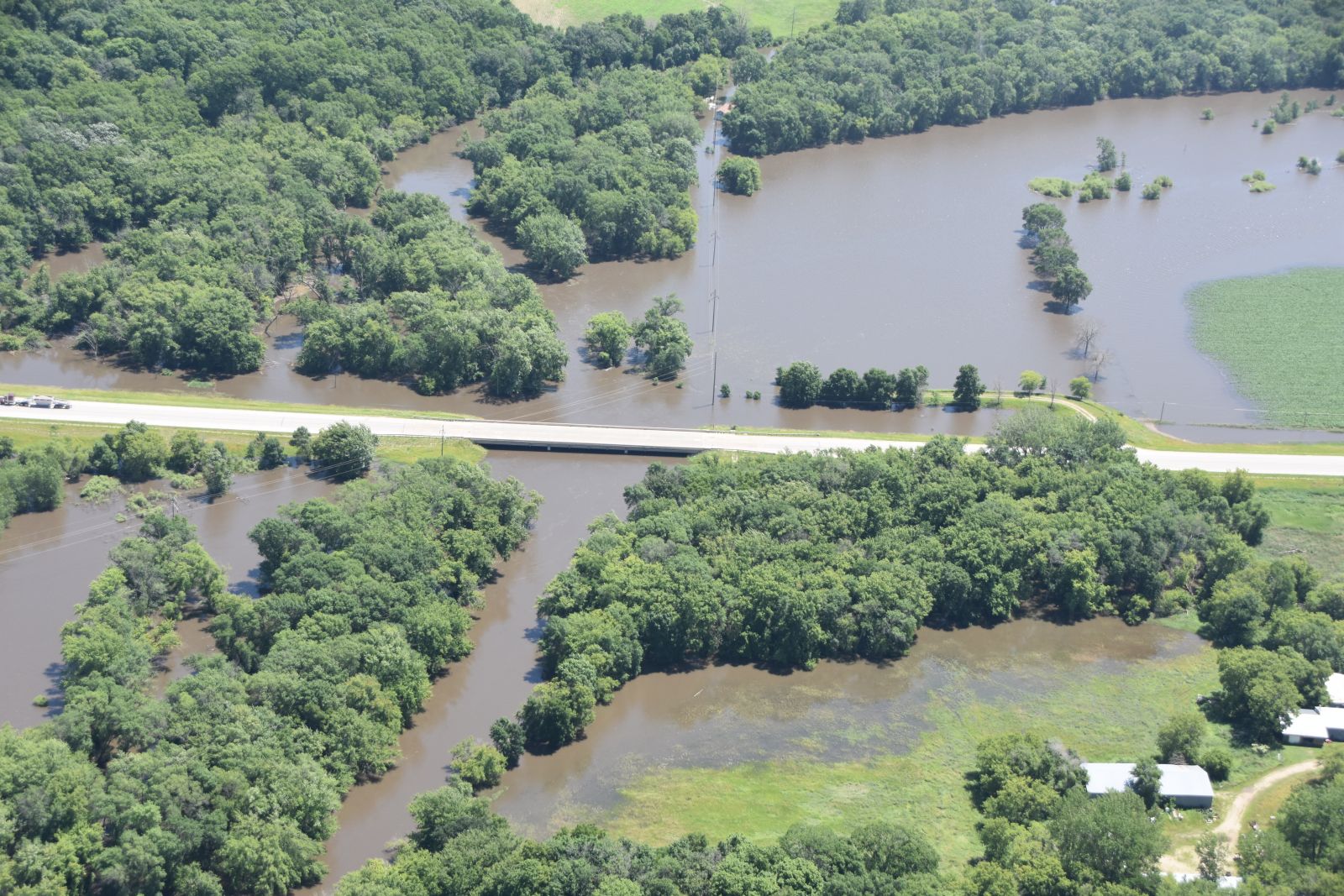
Waters of the Des Moines River flood along the banks next to the Fort Dodge Water Pollution Control Facility (Credit: Iowa Wing of the Civil Air Patrol) | The Highway 169 bridge is surrounded by flood waters of the East Fork Des Moines River south of Algona. (Credit: Iowa Wing of the Civil Air Patrol) | Flood waters inundated County Road C26 and surrounding areas northwest of Bradgate.(Credit: Iowa Wing of the Civil Air Patrol) |
Radar
 |
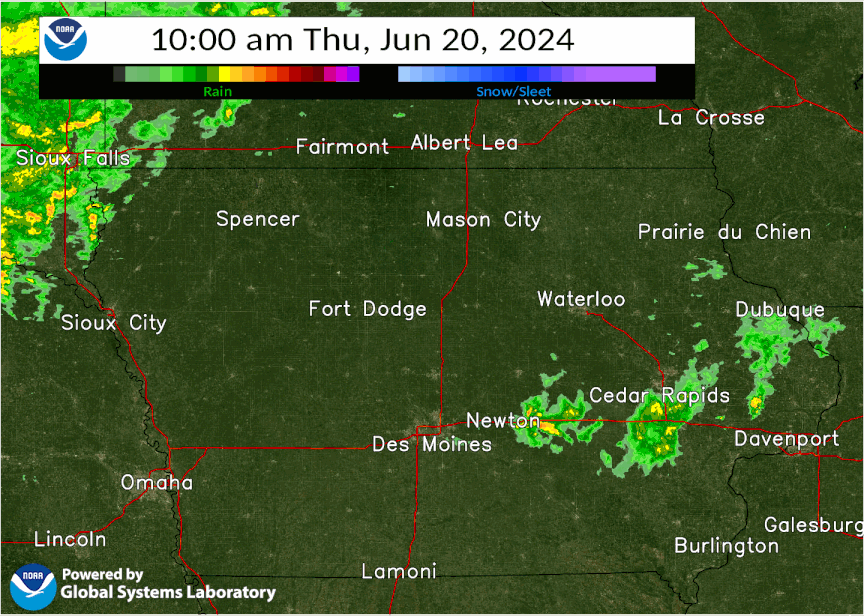 |
| Radar Loop from June 20, 2024 10am to June 23, 2024 at 10am | Same as left, but faster loop |
Satellite
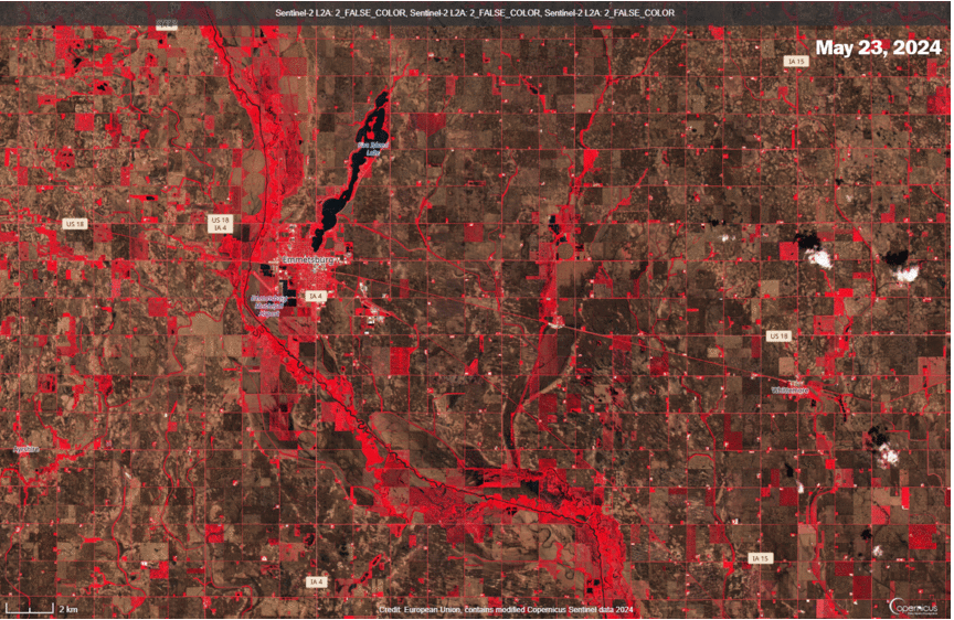
The first four images show false color satellite images toggling, or switching, between dates. The dates chosen are before the heavy rain fell and rivers started to rise with another image showing after the peak of the river flooding. Cities and exposed ground appearing as grey or tan and water appearing blue or black. Some images have clouds that show up as a textured, scattered white areas. For those interested in more information about false color imagery, see this NASA Earth Observatory article.
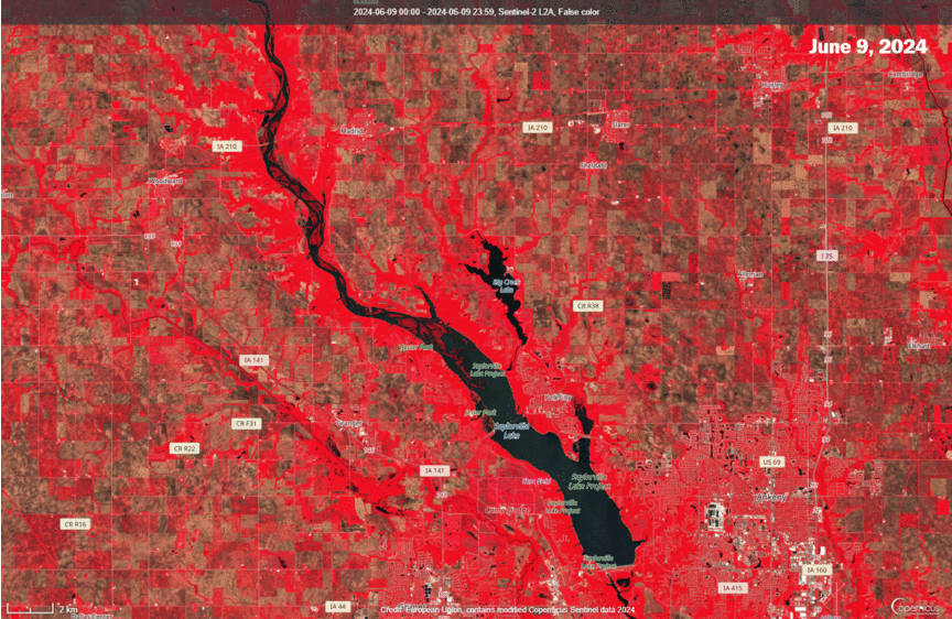 |
| Sentinel False Color imagery toggle between June 9, June 24, and July 14, 2024 showing Saylorville Lake near Des Moines, Iowa filling as floodwaters route their way down the Des Moines River to the reservoir. Note towards the top of the river 'islands' that disappear with time. Imagery from Copernicus Sentinel data 2024. |
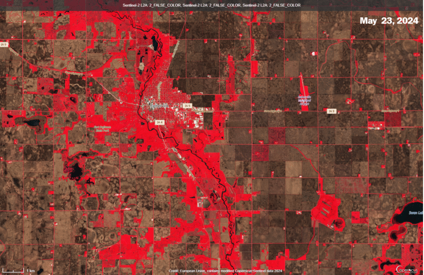 |
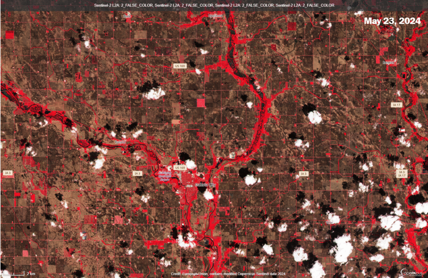
| Sentinel False Color Imagery toggle between May 23 to July 7, 2024 over Estherville, Iowa (just left of center). The West Fork Des Moines River, flowing from top to bottom in the image, is still swollen on the July 7 image with the Estherville river gage (ESVI4) at a stage of around 13 feet. Imagery from Copernicus Sentinel data 2024. |
 |
| Sentinel False Color Imagery toggle from May 23 to July 12, 2024 over Emmetsburg, Iowa (left of center). The West Fork Des Moines River, flowing from top to bottom in the image, is still swollen with water retained in oxbows and lowlands along the river on the July 12 image. The Emmetsburg river gage (EMTI4) at this time was at a stage of around 10.7 feet. Imagery from Copernicus Sentinel data 2024. |
 |
| Sentinel False Color Imagery toggle from May 23 to July 7, 2024 over Humboldt, Iowa. The West Fork Des Moines River is flowing from the left side into the bottom center. The East Fork Des Moines River is flowing from top to bottom in the image. On July 7, the West Fork of the Des Moines River is still swollen with water retained in oxbows and lowlands along the river. The Humboldt river gage (HBTI4) at this time was at a stage of around 12.9 feet. Imagery from Copernicus Sentinel data 2024. |
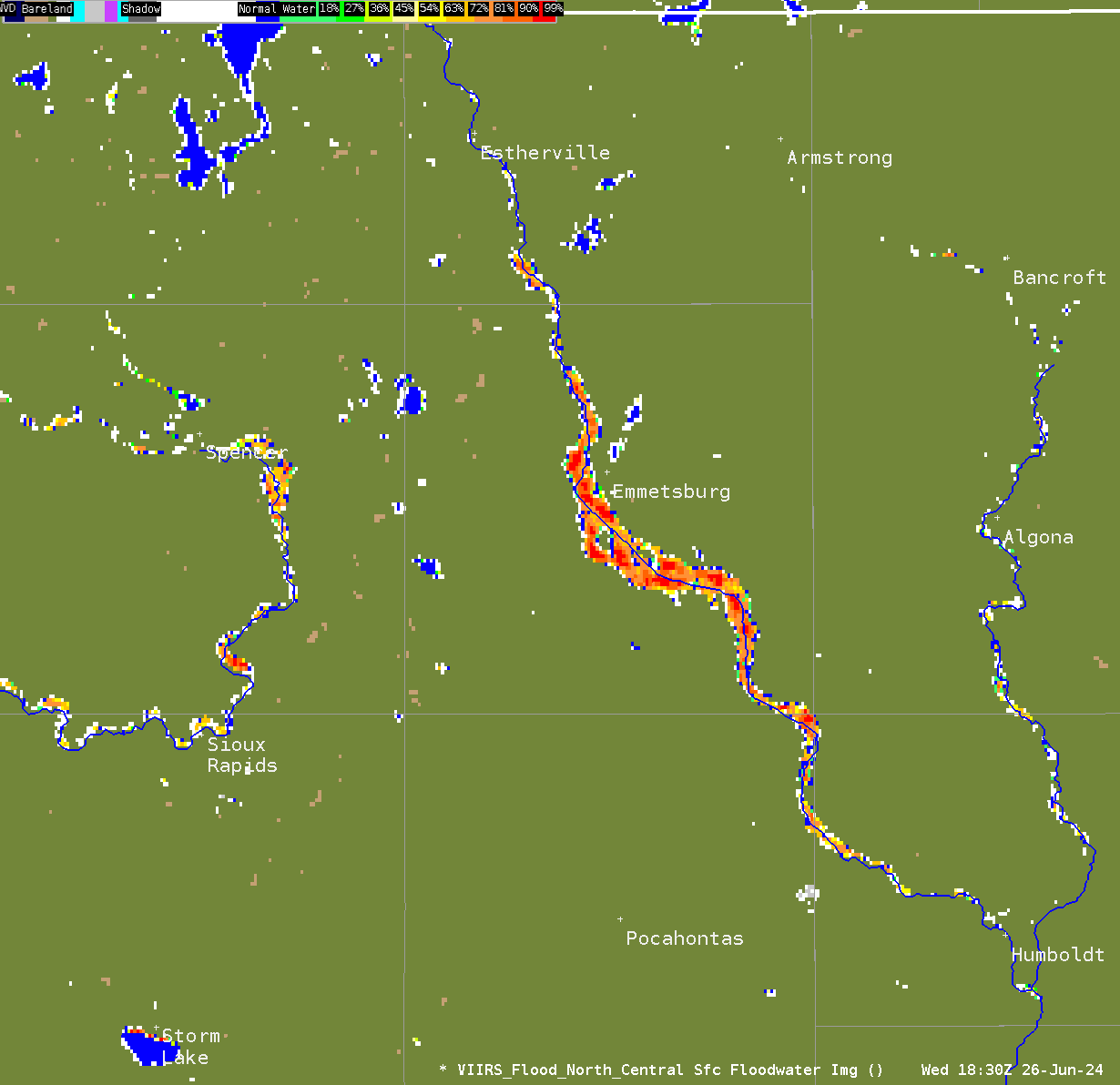 |
| Visible Infrared Imaging Radiometer Suite (VIIRS) satellite flood map shows flood inundation beyond the West Fork Des Moines River south of Estherville to just west of and south of Emmetsburg on June 26, 2024. |
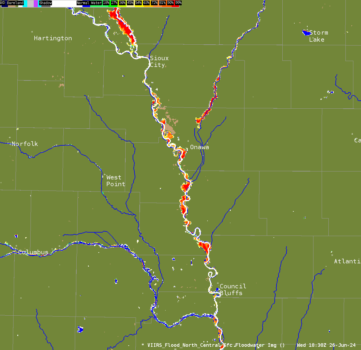 |
| Visible Infrared Imaging Radiometer Suite (VIIRS) satellite flood map shows flood inundation north of Sioux City due to the swollen Big Sioux River, along the Little Sioux River northeast of Onawa, and also the Missouri River on June 26, 2024. |
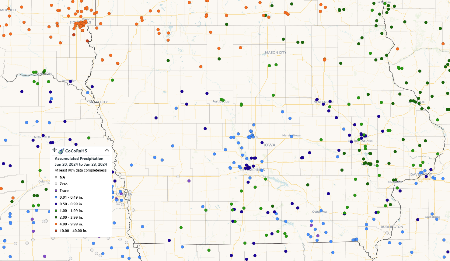
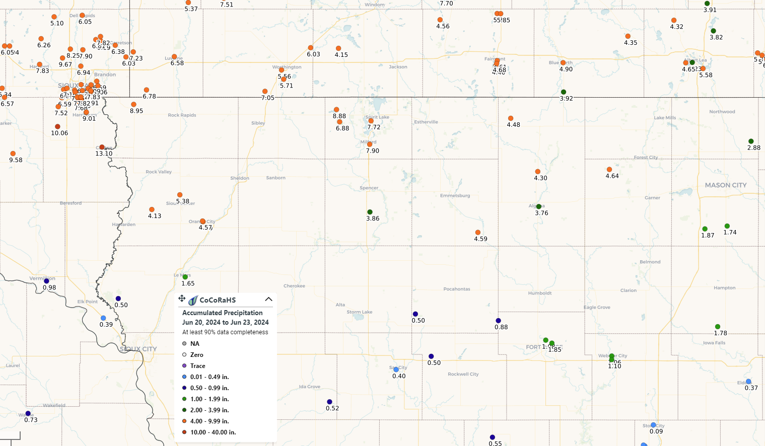
Rainfall Reports
 |
|||
| June 20-22, 2024 3 day MRMS Precipitation | |||
 |
 |
|
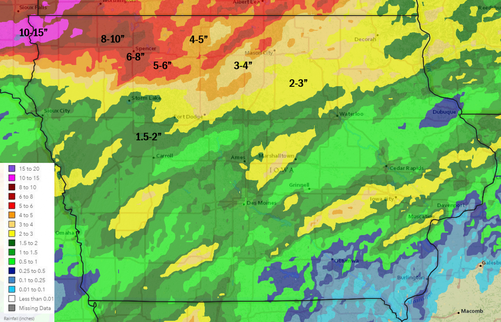 |
| CoCoRaHS rainfall reports June 20-23, 2024 | CoCoRaHS rainfall reports June 20-23, 2024 zoomed in over northwestern Iowa | June 20-22, 2024 3 day Multi-sensor Estimated Rainfall | June 18-22, 2024 5 day Multi-sensor Estimated Rainfall |
Preliminary Local Storm Report
National Weather Service Des Moines IA

..TIME...   ...EVENT...      ...CITY LOCATION...     ...LAT.LON...
..DATE...   ....MAG....      ..COUNTY LOCATION..ST.. ...SOURCE....
            ..REMARKS..
0100 AM Rain Mallard 42.94N 94.68W
06/22/2024 M3.47 Inch Palo Alto IA Mesonet
Mesonet station EW0956 Mallard.
0109 AM Rain 2 WNW Gruver 43.40N 94.75W
06/22/2024 M3.02 Inch Emmet IA ASOS
ASOS station KEST Estherville Airport.
0110 AM Rain 5 SE Hanlontown 43.23N 93.31W
06/22/2024 M3.28 Inch Cerro Gordo IA Mesonet
Mesonet station GW0743 Mason City.
0400 AM Rain 4 ESE Lake Cornelia 42.76N 93.62W
06/22/2024 M2.02 Inch Wright IA CO-OP Observer
CO-OP Observer station ROWI4 4.7 N Galt.
0408 AM Rain 2 WNW Gruver 43.40N 94.75W
06/22/2024 M2.67 Inch Emmet IA ASOS
ASOS station KEST Estherville Airport.
0600 AM Rain 2 WSW Goldfield 42.72N 93.95W
06/22/2024 M3.01 Inch Wright IA Mesonet
Mesonet station GLDI4 1.5 SW Goldfield.
0600 AM Rain 1 NW Burt 43.21N 94.23W
06/22/2024 M3.30 Inch Kossuth IA Cocorahs
Cocorahs station IA-KS-5 Burt 0.5 NW. 3.30 inches.
0630 AM Rain Mallard 42.94N 94.68W
06/22/2024 M3.78 Inch Palo Alto IA Mesonet
Mesonet station EW0956 Mallard.
0630 AM Rain 2 WSW Crystal Lake 43.21N 93.84W
06/22/2024 M4.26 Inch Hancock IA Cocorahs
Cocorahs station IA-HN-8 Britt 8.2 NNW. 4.26 inches.
0635 AM Rain Grafton 43.33N 93.08W
06/22/2024 M2.68 Inch Worth IA Mesonet
Mesonet station EW5720 Grafton.
0658 AM Rain Buffalo Center 43.39N 93.94W
06/22/2024 M4.00 Inch Winnebago IA Public
Report from social media.
0700 AM Rain 2 NE Bode 42.89N 94.26W
06/22/2024 M3.30 Inch Humboldt IA Cocorahs
Cocorahs station IA-HB-4 Bode 1.9 NE. 3.30 inches.
0700 AM Rain 5 SSW Rodman 42.96N 94.55W
06/22/2024 M4.41 Inch Palo Alto IA Cocorahs
Cocorahs station IA-PA-5 West Bend 5.4 W. 4.41 inches.
0700 AM Rain 1 SE Algona 43.07N 94.22W
06/22/2024 M3.71 Inch Kossuth IA Cocorahs
Cocorahs station IA-KS-4 Algona 0.7 SE. 3.71 inches.
0700 AM Rain 1 SE Algona 43.07N 94.22W
06/22/2024 M3.71 Inch Kossuth IA Mesonet
Mesonet station ALGI4 Algona. 3.71 inches.
0700 AM Rain 2 WSW Goldfield 42.72N 93.95W
06/22/2024 M3.01 Inch Wright IA Mesonet
Mesonet station GLDI4 1.5 SW Goldfield. 3.01 inches.
0733 AM Rain 5 SSE Dumont 42.69N 92.92W
06/22/2024 M4.50 Inch Butler IA Trained Spotter
Rainfall report ending at 7:30 am from
yesterday evenings and this mornings
rainfall.
0823 AM Rain 2 NNW Fort Dodge 42.53N 94.18W
06/22/2024 M3.06 Inch Webster IA Mesonet
Mesonet station GW4516 FORT DODGE. 3.06 inches.
0825 AM Rain 2 WNW Gruver 43.40N 94.75W
06/22/2024 M3.16 Inch Emmet IA ASOS
ASOS station KEST Estherville Airport. 3.16 inches.
0830 AM Rain 2 S Algona 43.04N 94.23W
06/22/2024 M4.00 Inch Kossuth IA Public
Public relayed, via social media, 4 inches
of rainfall from yesterday evening and
overnight.
0830 AM Rain 5 SE Hanlontown 43.23N 93.31W
06/22/2024 M4.26 Inch Cerro Gordo IA Mesonet
Mesonet station GW0743 Mason City. 4.26 inches.
0830 AM Rain 1 NNW Algona 43.08N 94.24W
06/22/2024 M3.14 Inch Kossuth IA Mesonet
Mesonet station 3044D Algona. 3.14 inches.
0830 AM Rain 1 ENE West Bend 42.96N 94.45W
06/22/2024 M7.50 Inch Palo Alto IA Public
This is from Friday 6 am through 830am this
morning. Public, via social media, relayed
7.5 inches rainfall.
0845 AM Rain 1 NW Britt 43.11N 93.82W
06/22/2024 M4.50 Inch Hancock IA Public
Public, via social media, relayed 4.50
inches of rain from yesterday evening and
overnight.
0850 AM Rain 4 W Manly 43.29N 93.28W
06/22/2024 M3.18 Inch Worth IA Public
Public, via social media, relayed rainfall
amount of 3.18 inches from evening and
overnight.
0850 AM Rain 1 S Thompson 43.36N 93.77W
06/22/2024 M5.10 Inch Winnebago IA Public
Public, via social media, relayed 5.10
inches of rain from yesterday evening and
overnight.
0850 AM Rain Clear Lake 43.14N 93.37W
06/22/2024 M5.00 Inch Cerro Gordo IA Public
Public, via social media, relayed 5 inches
of rain from yesterday evening and
overnight.
0900 AM Rain Lake Mills 43.42N 93.53W
06/22/2024 M4.50 Inch Winnebago IA Public
Public, via social media, relayed 4.5 inches
rainfall from yesterday evening and
overnight.
0900 AM     Rain             2 W Denver              42.67N 92.36W

06/22/2024  M5.00 Inch       Bremer             IA   Public


            Public, via social media, relayed 5 inches

            rainfall from yesterday evening and

            overnight.
0914 AM Rain Bancroft 43.29N 94.22W
06/22/2024 M5.25 Inch Kossuth IA Public
Public, via social media, relayed 5.25
inches of rain from yesterday evening and
overnight.
1000 AM Rain Buffalo Center 43.39N 93.94W
06/22/2024 M4.00 Inch Winnebago IA Public
Public, via social media, relayed 4 inches
rainfall from yesterday evening and
overnight.
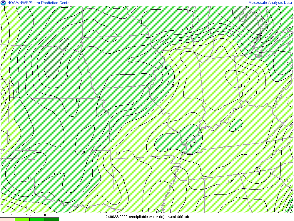
Environment
 |
 |
 |
| Precipitable water (PWAT) loop showing an increasing amount of moisture with anomalous PWATs over 2 inches over Siouxland on the evening of June 21, 2024. PWAT is the amount of water in a column from the surface to the top of the atmosphere |
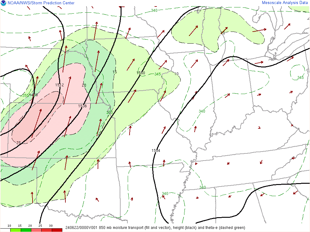
Figure 2: High values of 850mb moisture transport expanding from Nebraska into western Iowa on the evening of June 21, 2024. High values of moisture transport have been related to heavy rainfall potential with convective systems. |
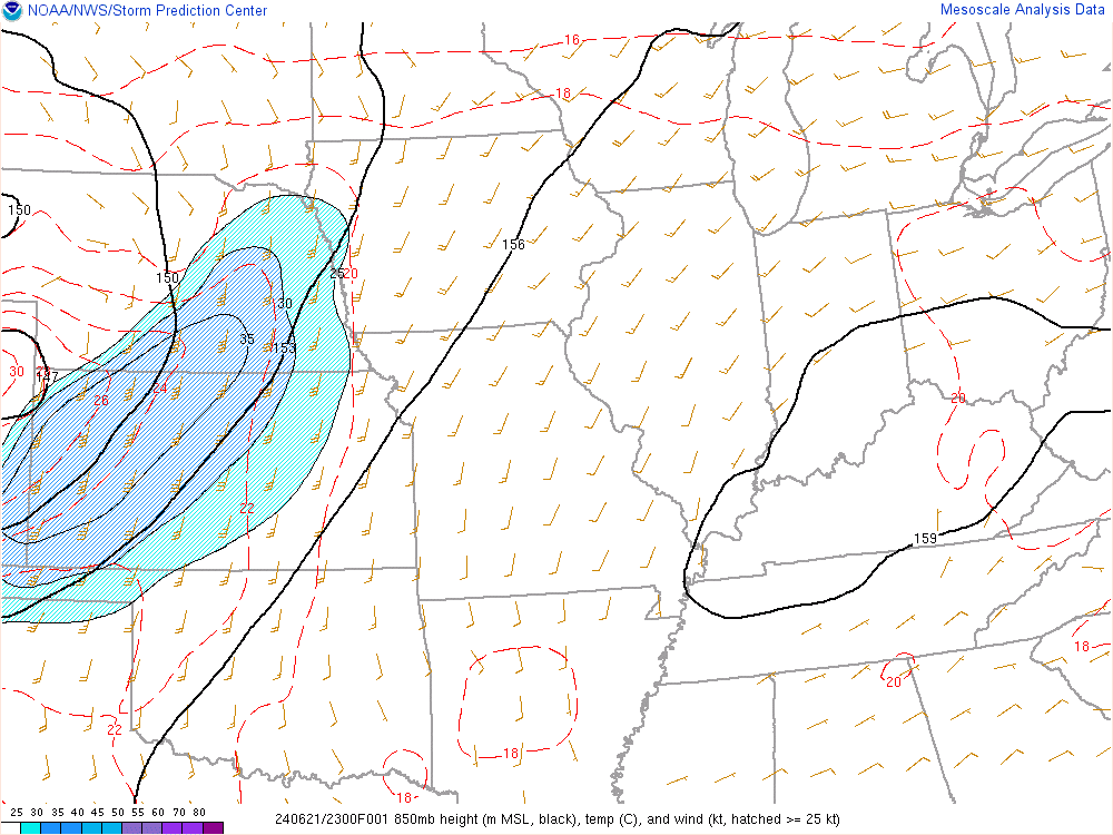
Figure 3: 850mb winds show a strong low level jet (blue shades) over Kansas and Nebraska that expands into Iowa on the evening of June 21, 2024. |
Additional Information
Excessive Rainfall Outlooks
The NWS Weather Prediction Center issues "Excessive Rainfall Outlooks", or EROs", highlighting areas that will exceed flash flood guidance and assigns a marginal (MRGL), slight (SLGT), moderate (MDT), or High (High) risk areas. Below, you see their forecasts for June 20-22, 2024 including their day 1 forecast (on the day of the event), day 2 forecast (a day before the event), and day 3 forecast (2 days before the event). The Day 1 forecasts shows that a heightened flash flood risk existed with a moderate risk being issued each day between June 20-22 for some portion of Iowa. On the Day 2 outlook, a moderate risk was issued for June 21 over northern Iowa while the day 3 outlook issued a slight risk for June 21 over northern Iowa.
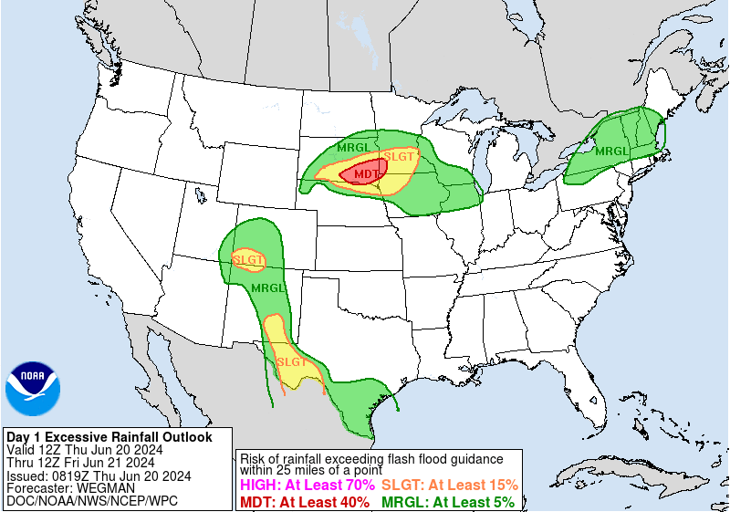 |
| Day 1 Excessive Rainfall Outlooks shows moderate (red area, MDT) over extreme northwest Iowa on June 20, expands over northern all of northern Iowa on June 21, and exits northeastern Iowa on June 22, 2024. |
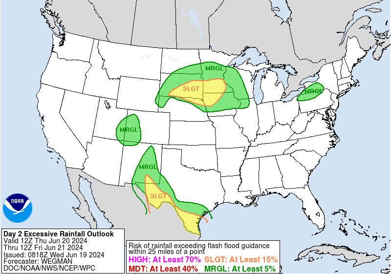 |
| Day 2 Excessive Rainfall Outlooks shows a slight risk (yellow, SLGT) over northwest Iowa on June 20 and a moderate risk (red area, MDT) over northwest and north central Iowa on June 21, 2024. |
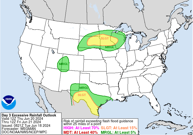 |
| Day 3 Excessive Rainfall Outlooks shows a marginal risk (green, MRGL) over northern Iowa on June 20, and a slight risk (yellow, SLGT) over northern Iowa on June 21, and a marginal risk (green, MRGL) over much of Iowa on June 22, 2024. |
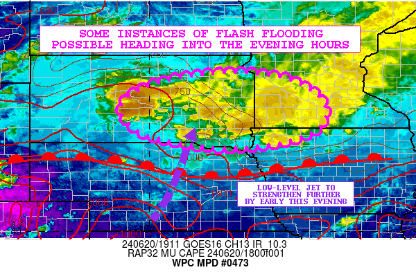
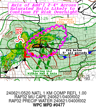
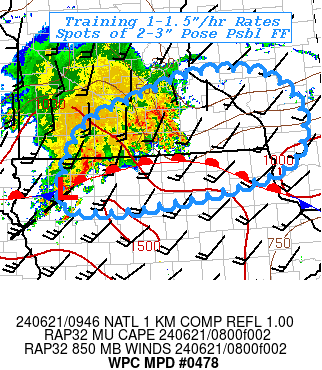
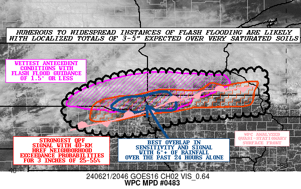
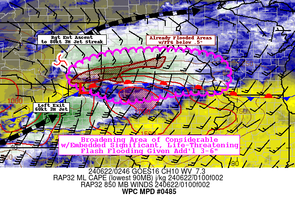
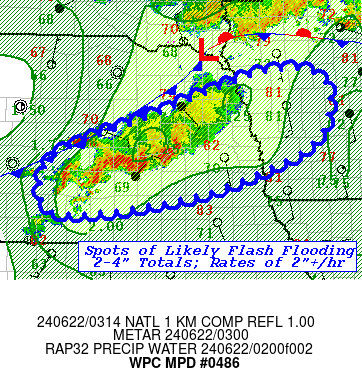
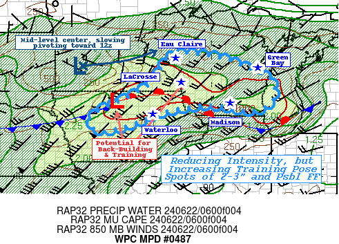
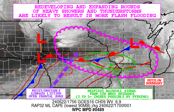
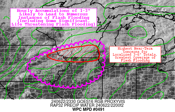
Mesoscale Precipitation Discussion
 |
 |
 |
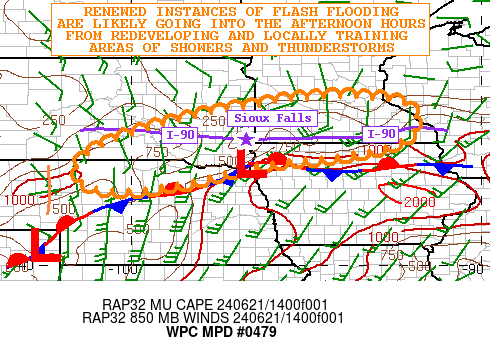 |
| Mesoscale Precipitation Discussion Issued 216 pm June 20. 2024 |
Mesoscale Precipitation Discussion Issued 1223 am June 21. 2024 |
Mesoscale Precipitation Discussion Issued 449 am June 21. 2024 |
Mesoscale Precipitation Discussion Issued 1005 am June 21. 2024 |
 |
 |
 |
 |
| Mesoscale Precipitation Discussion Issued 352 pm June 21. 2024 |
Mesoscale Precipitation Discussion Issued 953 pm June 21. 2024 |
Mesoscale Precipitation Discussion Issued 1016 pm June 21. 2024 |
Mesoscale Precipitation Discussion Issued 223 am June 22. 2024 |
 |
 |
||
| Mesoscale Precipitation Discussion Issued 100 pm June 22. 2024 |
Mesoscale Precipitation Discussion Issued 653 pm June 22. 2024 |
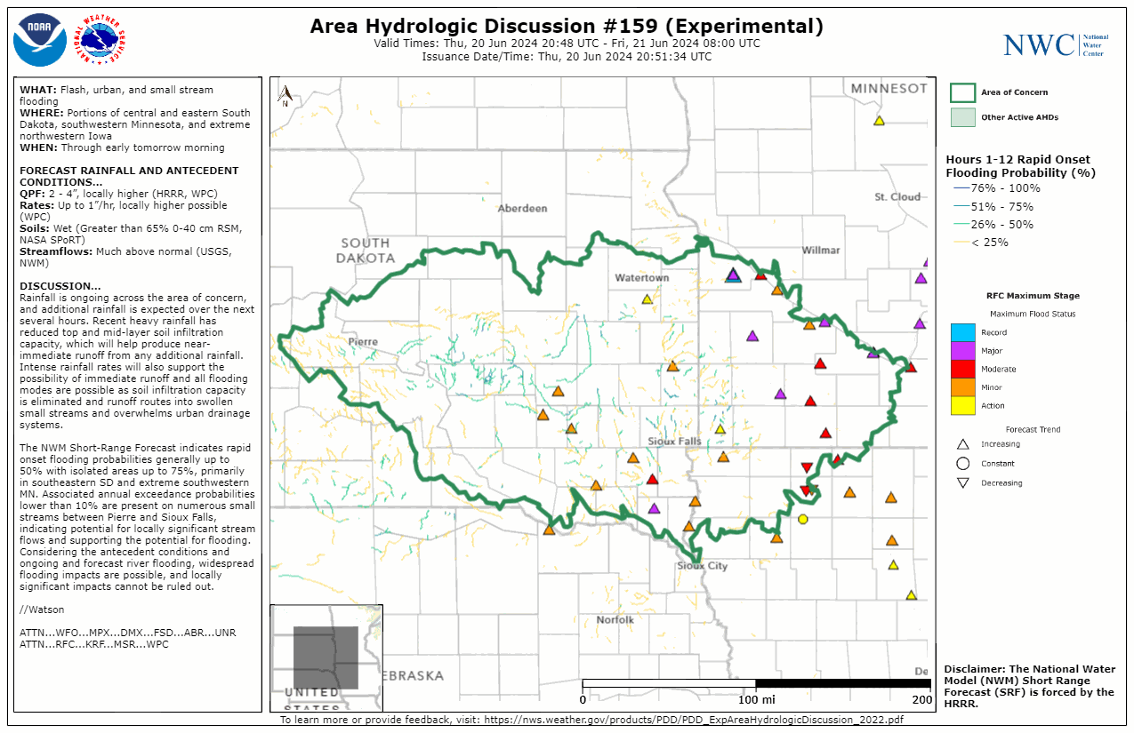
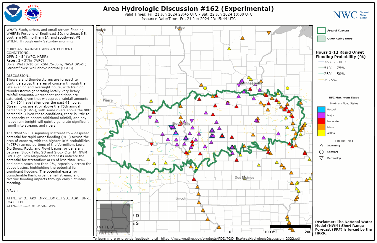
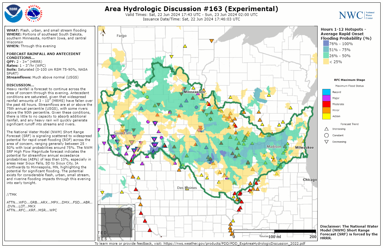
National Water Center Area Hydrologic Discussion
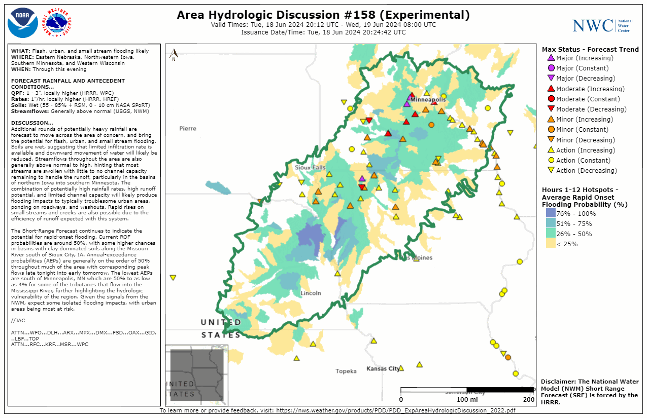 |
 |
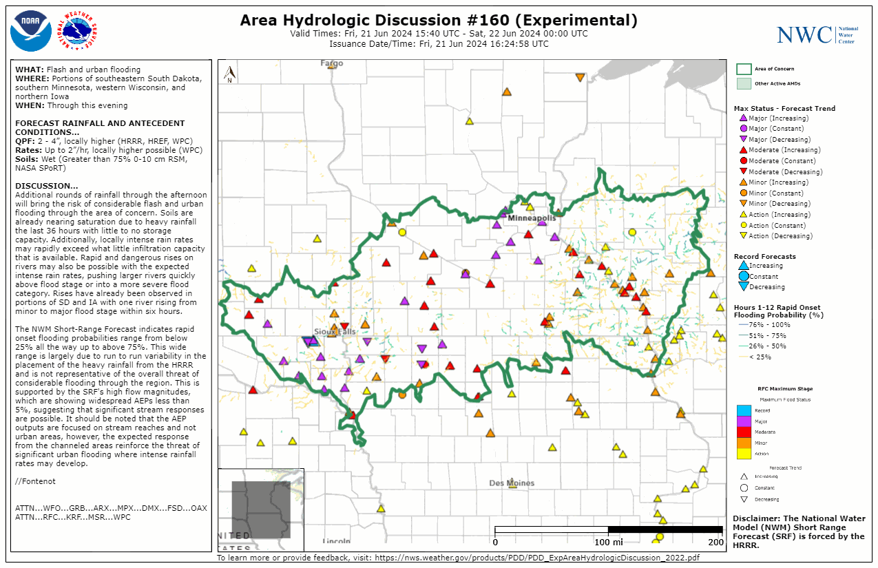 |
| June 18, 2024 3pm - June 19, 2024 3am | June 20, 2024 3pm - June 21, 2024 3am | June 21, 2024 11am - June 21, 2024 7pm |
 |
 |
|
| June 21, 2024 7pm - June 21, 2024 5am | June 22, 2024 1pm - June 22, 2024 9pm |
Three Day Total - Iowa Environmental Mesonet June 24, 2024 Feature
 |
Media use of NWS Web News Stories is encouraged! Please acknowledge the NWS as the source of any news information accessed from this site. |
|

