Thunderstorms, some severe, may produce heavy to excessive rainfall and isolated flooding over portions of the Southern Plains today and Saturday. Dry conditions, combined with gusty winds and low relative humidities will continue to support an elevated to critical fire weather threat in the Desert Southwest into to early next week. Read More >
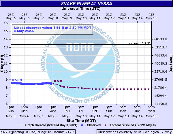
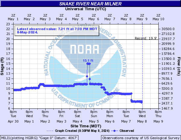
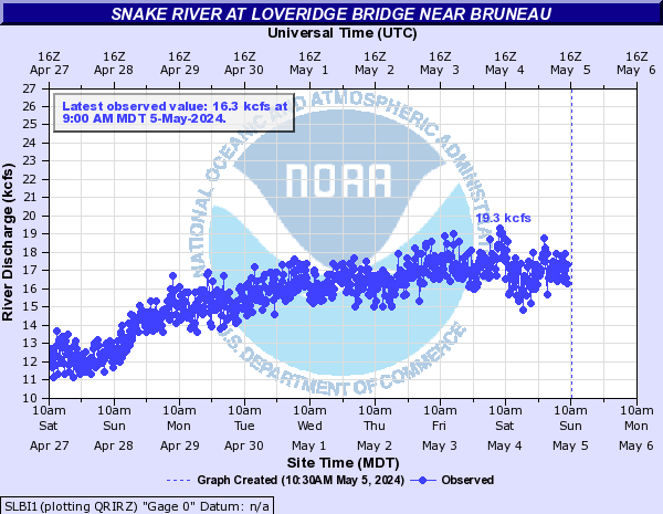
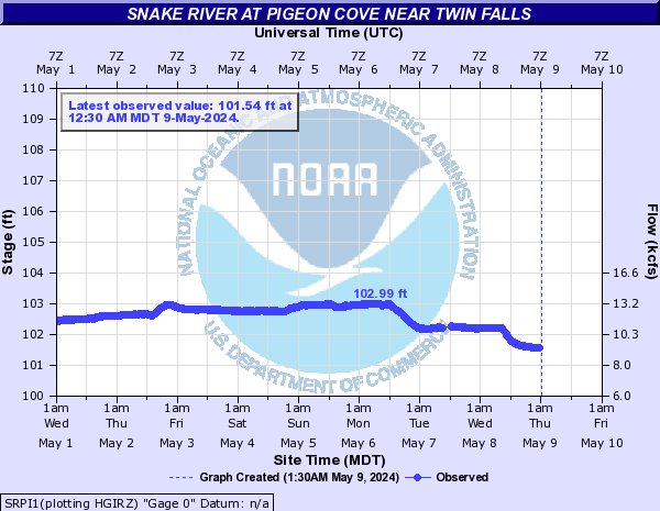
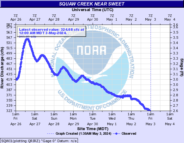
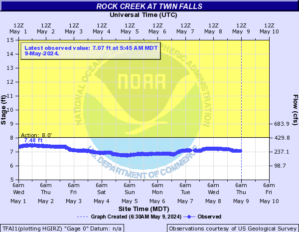
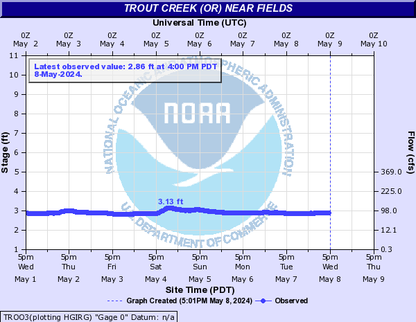
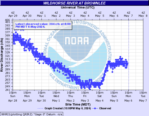
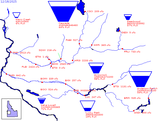
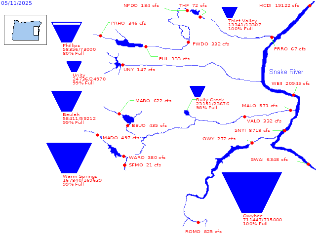
Mouse over each site to display hydrograph.
Hydrographs (showing stages and flows over time) are available through AHPS (Advanced Hydrologic Prediction Service) by clicking site names.
| No Flood | Near Flood | Minor Flood | Moderate Flood | Major Flood |
| River Conditions at: 9:02 PM 05/19/2024 | |||||||||
Location | Flood Flow/Stage | Observed Flow/Stage | 24-Hr Change | Max Forecast | Forecast for 6AM | ||||
| Mon. | Tue. | Wed. | Thu. | Fri. | |||||
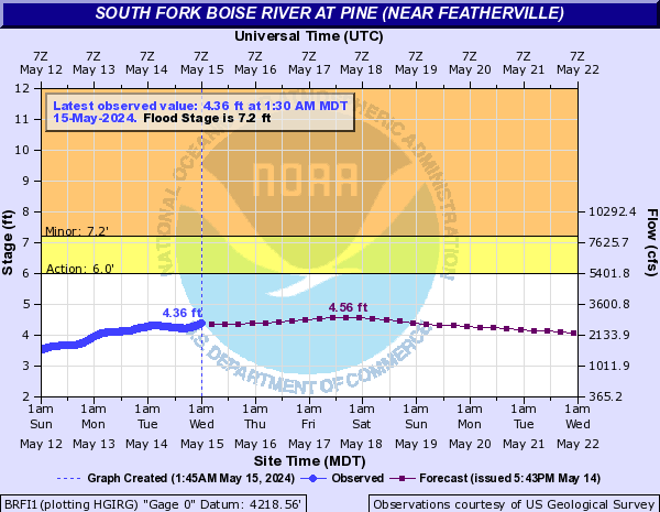
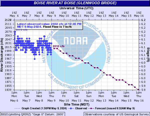
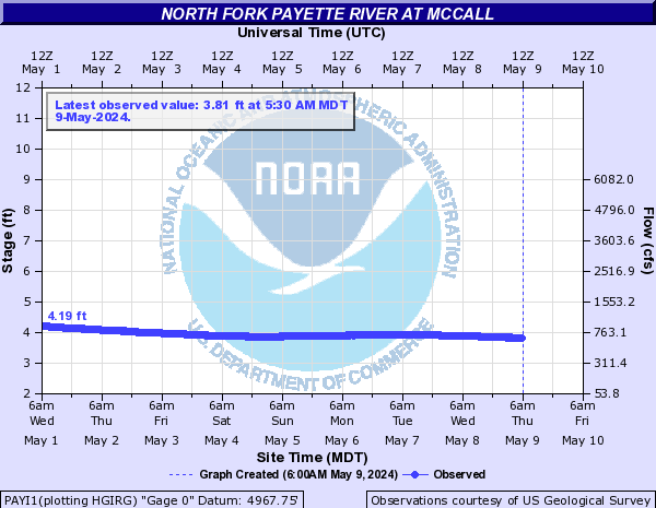
| Boise River | 7.2 | 4.19 ft | -0.2 | 4.26 | 4.16 | 4.14 | 4.02 | 4.24 | 4.09 | - | 1640.41 cfs | -24.73 | 1673.0 | 1673.0 | 1673.0 | 1673.0 | 1673.0 | 1673.0 | - | 8.95 ft | -0.31 | 9.49 | 8.9 | 8.74 | 8.64 | 9.4 | 9.27 | - | 7914.76 cfs | -545.28 | 7914 | 6296.5 | 5568.0 | 5056.3 | 5557.9 | 5064.2 | 7000.00 | 1902.0 cfs | -28.0 | 1902 | 1900.0 | 1900.0 | 1900.0 | 1900.0 | 1900.0 | - | 8.39 ft | -0.01 | - | - | - | - | - | - | - | 4.54 ft | -0.07 | - | - | - | - | - | - | - | 9.7 ft | +0.03 | 9.84 | 9.77 | 9.76 | 9.68 | 9.82 | 9.84 |
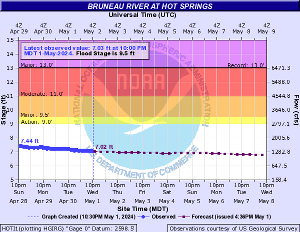
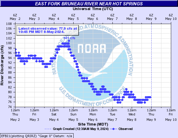
| Bruneau River | 9.5 | 7.71 ft | -0.1 | 7.71 | 7.65 | 7.53 | 7.39 | 7.28 | 7.17 | - | 120.0 cfs | +5.0 | - | - | - | - | - | - |
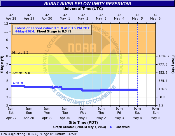
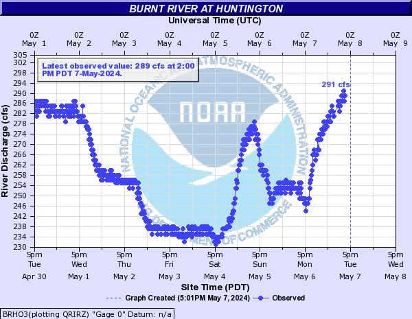
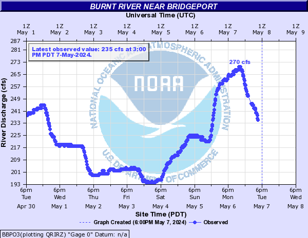
| Burnt River | 8.3 | 3.6 ft | 0.0 | - | - | - | - | - | - | - | 138.0 cfs | -1.0 | - | - | - | - | - | - | - | 98.0 cfs | -1.0 | - | - | - | - | - | - | - | 3.77 ft | -0.05 | - | - | - | - | - | - |
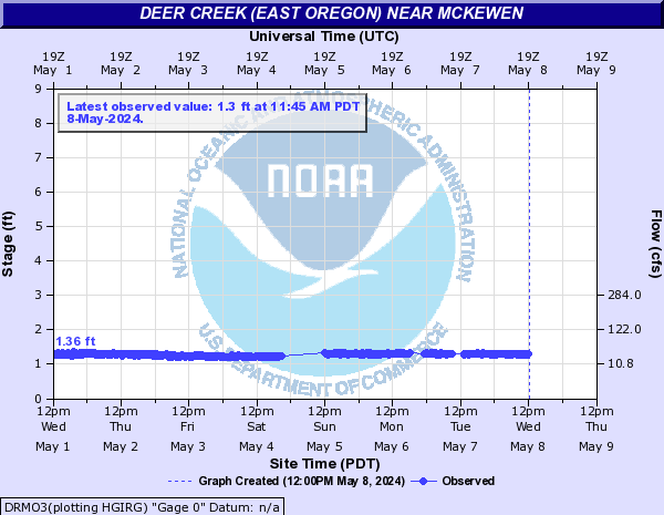
| Deer Creek (East Oregon) | - | 1.54 ft | -0.1 | - | - | - | - | - | - |
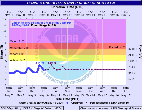
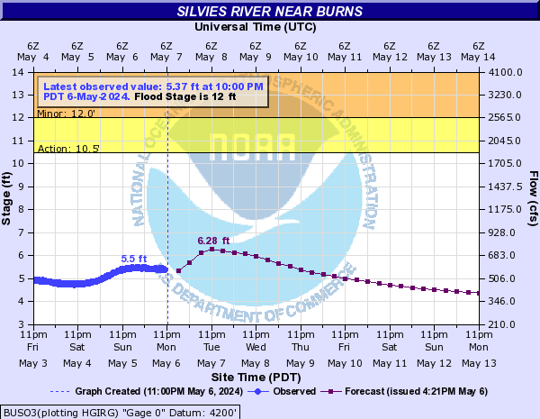
| Donner und Blitzen River | 6 | 3.45 ft | -0.07 | 3.69 | 3.57 | 3.29 | 3.19 | 3.17 | 3.07 |
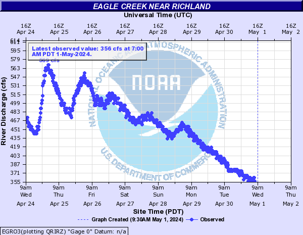
| Eagle Creek | - | 786.0 cfs | -117.0 | 1063.2 | 786.4 | 808.6 | 815.2 | 1006.1 | 1055.5 | - | 583.0 cfs | -97.0 | - | - | - | - | - | - |
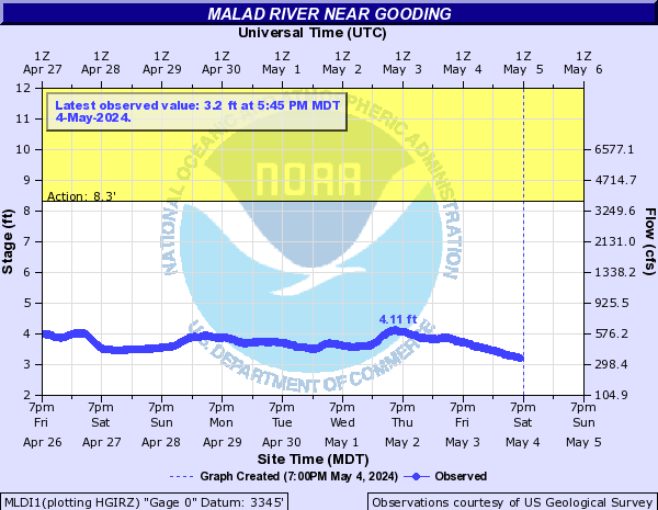
| Malad River | - | 177.0 cfs | -9.0 | - | - | - | - | - | - | - | 3.69 ft | -0.11 | - | - | - | - | - | - |
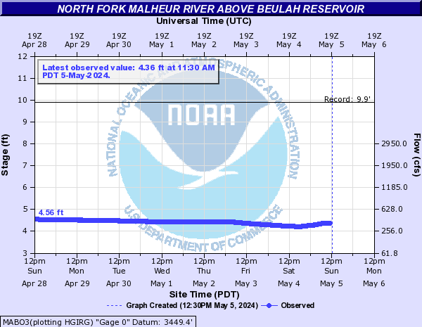
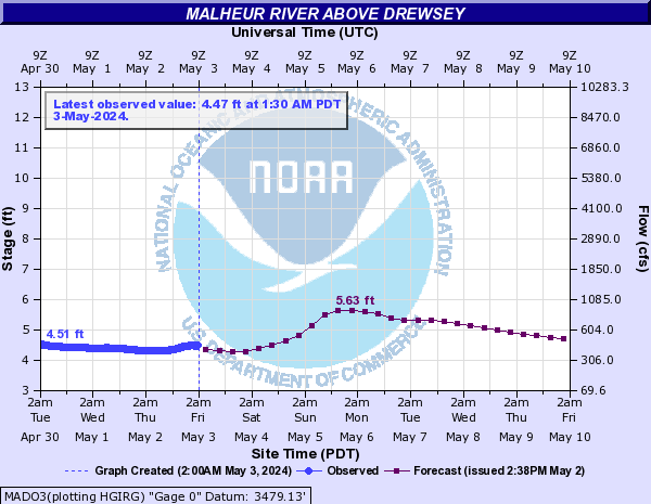
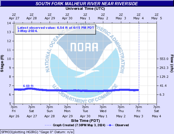
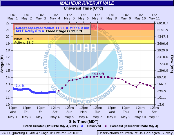
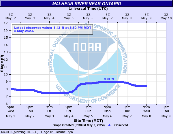
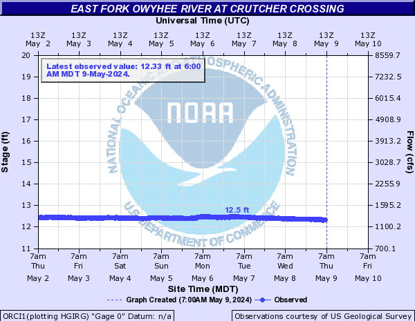
| Malheur River | - | 4.49 ft | -0.05 | - | - | - | - | - | - | - | 3.29 ft | 0.0 | - | - | - | - | - | - | - | 4.05 ft | -0.11 | 4.05 | 4.0 | 3.94 | 3.89 | 3.85 | 3.79 | - | 6.26 ft | -0.11 | - | - | - | - | - | - | 19.5 | 11.3 ft | +0.16 | 11.68 | 11.26 | 11.25 | 11.02 | 11.68 | 11.57 | - | 4.44 ft | +0.02 | - | - | - | - | - | - | - | 7.06 ft | +0.22 | - | - | - | - | - | - |
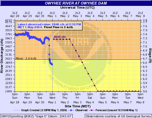
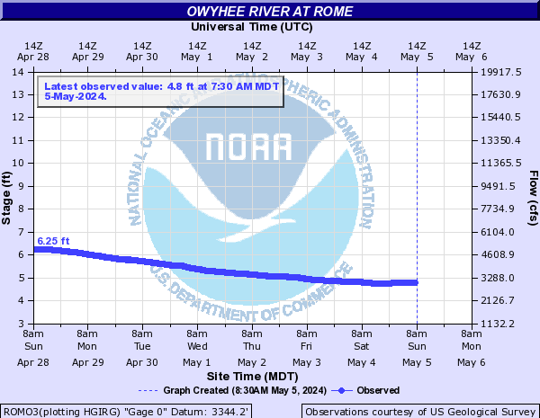
| Owyhee River | 3000.00 | 1246.0 cfs | -6.0 | 1250.0 | 1250.0 | 1250.0 | 1250.0 | 1250.0 | 1250.0 | - | 4.28 ft | -0.13 | - | - | - | - | - | - | - | 11.92 ft | -0.03 | - | - | - | - | - | - |
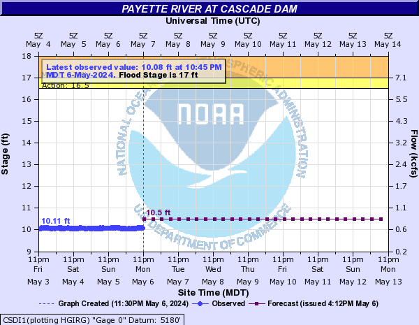
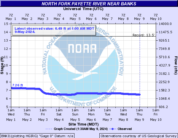
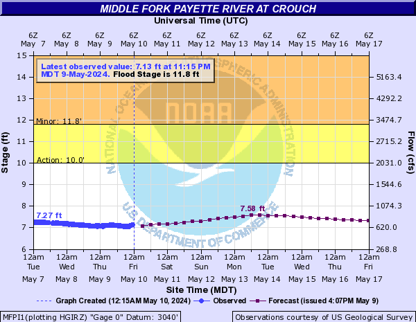
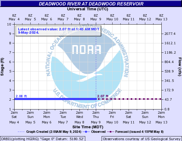
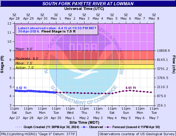
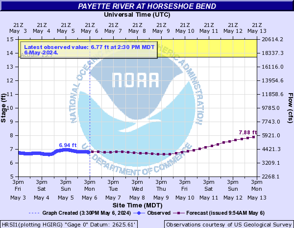
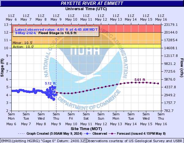
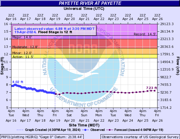
| Payette River | - | 4.74 ft | -0.57 | - | - | - | - | - | - | 17 | 10.99 ft | +0.02 | 11.2 | 11.2 | 11.2 | 11.2 | 11.2 | 11.2 | - | 7.34 ft | -0.07 | - | - | - | - | - | - | 11.8 | 8.09 ft | -0.24 | 8.71 | 8.07 | 7.93 | 7.83 | 8.61 | 8.42 | - | 3.73 ft | 0.0 | 3.74 | 3.74 | 3.74 | 3.74 | 3.74 | 3.74 | 7.5 | 5.1 ft | -0.18 | 5.1 | 5.0 | 4.86 | 4.76 | 4.88 | 4.89 | - | 8.4 ft | -0.27 | 8.4 | 8.27 | 7.99 | 7.8 | 8.12 | 8.18 | 10.5 | 6.16 ft | -0.15 | 6.16 | 5.87 | 5.49 | 5.25 | 5.53 | 5.76 | - | 11.91 ft | -0.18 | - | - | - | - | - | - | 12 | 7.34 ft | -0.16 | 7.34 | 7.11 | 6.78 | 6.58 | 6.63 | 7.01 |
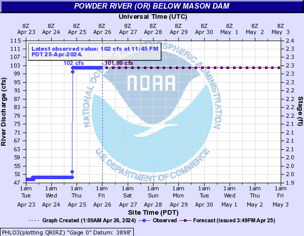
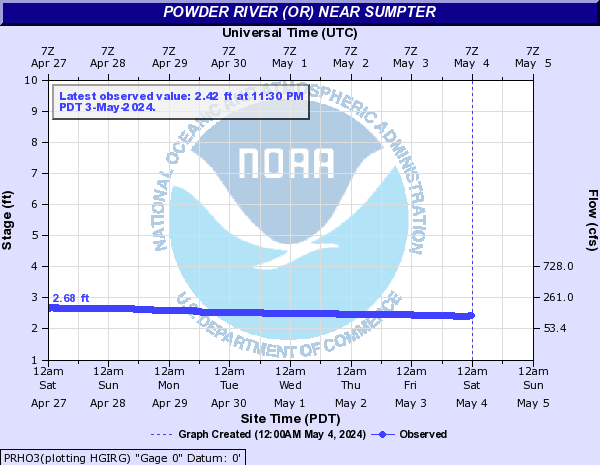
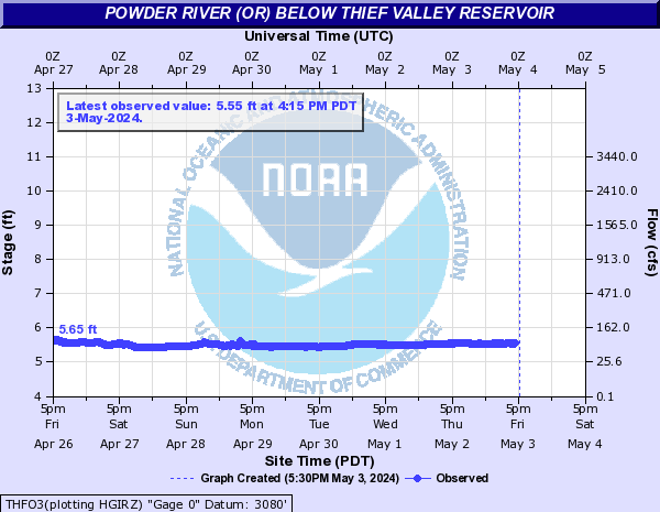
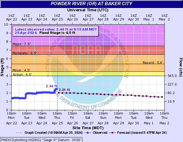
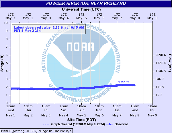
| Powder River | - | 311.0 cfs | 0.0 | 311 | 310.0 | 310.0 | 310.0 | 310.0 | 310.0 | - | 2.8 ft | -0.06 | - | - | - | - | - | - | - | 6.02 ft | -0.29 | - | - | - | - | - | - | 4.5 | 3.32 ft | +0.02 | 3.32 | 3.3 | 3.29 | 3.29 | 3.31 | 3.29 | - | 2.06 ft | -0.04 | - | - | - | - | - | - |
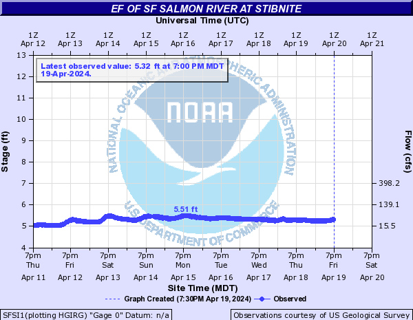
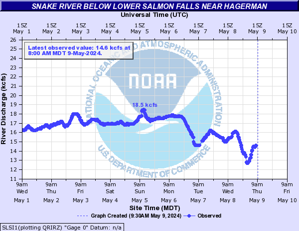
| Salmon River | - | 5.19 ft | -0.31 | - | - | - | - | - | - | - | 5.8 ft | -0.1 | - | - | - | - | - | - | - | 4.79 ft | -0.33 | 4.79 | 4.62 | 4.27 | 4.01 | 4.15 | 4.16 |
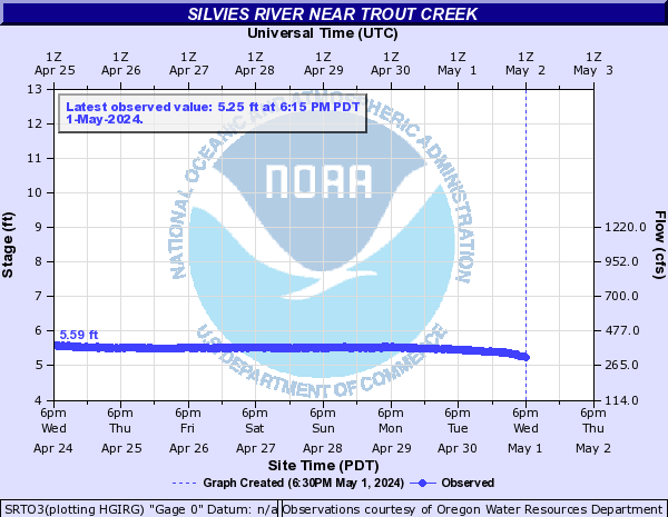
| Silvies River | - | 4.09 ft | -0.08 | - | - | - | - | - | - | 12 | 3.0 ft | -0.13 | 3.01 | 2.99 | 2.89 | 2.82 | 2.77 | 2.69 |
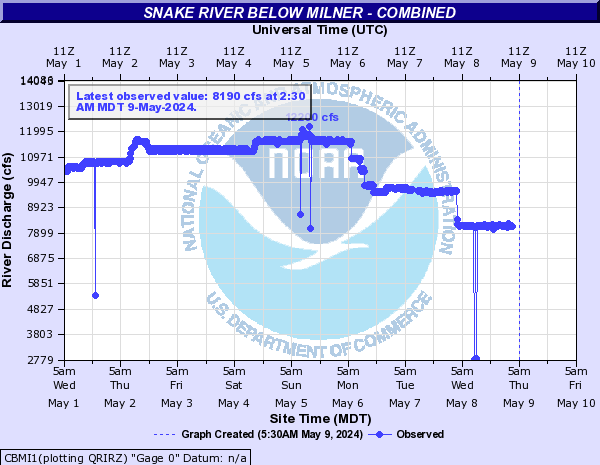
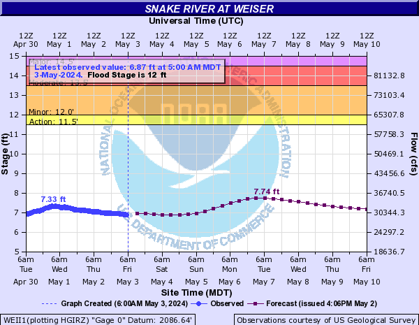
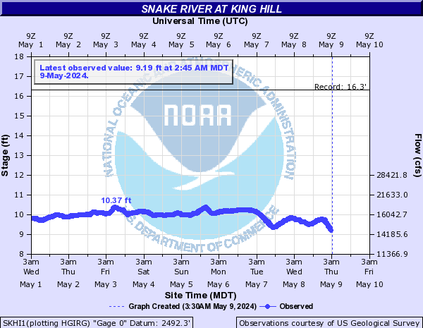
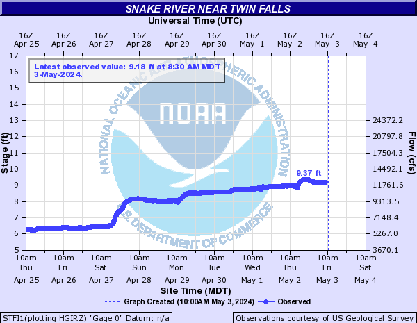
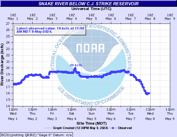
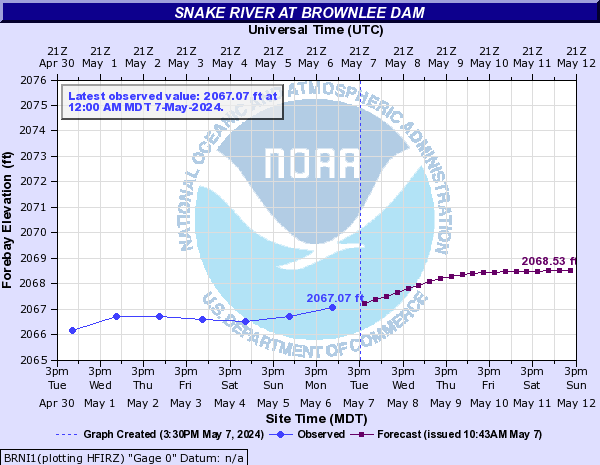
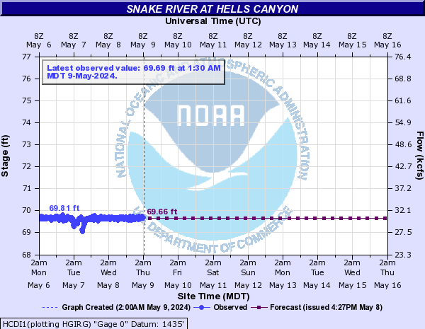
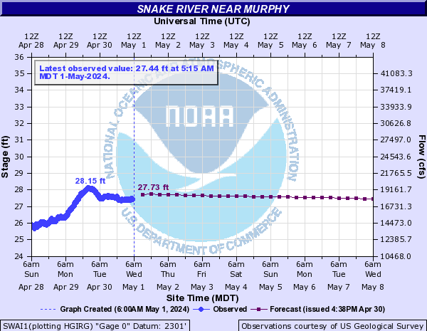
| Snake River | - | 559.0 cfs | -102.0 | - | - | - | - | - | - | 12 | 5.35 ft | 0.0 | 5.39 | 5.35 | 5.04 | 4.88 | 4.94 | 5.12 | - | 6.06 ft | -0.24 | - | - | - | - | - | - | - | 5810.0 cfs | -200.0 | - | - | - | - | - | - | - | 2.67 ft | +0.23 | - | - | - | - | - | - | - | 7230.0 cfs | -300.0 | - | - | - | - | - | - | - | 8930.0 cfs | +400.0 | - | - | - | - | - | - | - | 2069.71 ft | +0.02 | 2072.25 | 2070.04 | 2070.46 | 2070.88 | 2071.3 | 2071.73 | - | 6.25 ft | +0.15 | 6.25 | 6.21 | 6.14 | 6.08 | 6.07 | 6.06 | - | 1.12 ft | -0.07 | - | - | - | - | - | - | - | 2.1 ft | +0.03 | - | - | - | - | - | - | - | 556.0 cfs | -97.0 | - | - | - | - | - | - | - | 7060.0 cfs | -250.0 | - | - | - | - | - | - | - | 96.38 ft | +0.01 | - | - | - | - | - | - | - | 68.55 ft | -0.06 | 68.55 | 67.12 | 66.58 | 66.29 | 66.24 | 66.57 | - | 22.26 ft | -0.59 | - | - | - | - | - | - |
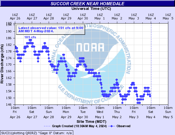
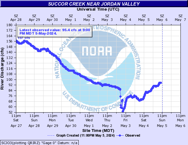
| Succor Creek | - | 117.0 cfs | +5.0 | - | - | - | - | - | - | - | 65.9 cfs | -5.6 | - | - | - | - | - | - |
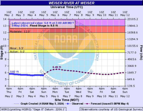
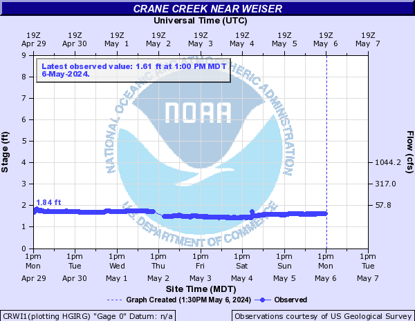
| Weiser River | 9.5 | 6.06 ft | -0.14 | 6.51 | 6.0 | 5.84 | 5.76 | 6.42 | 6.35 | 12 | 5.08 ft | -0.15 | 6.0 | 5.03 | 4.91 | 5.0 | 6.0 | 5.67 |
| Other Rivers and Creeks | - | 8.2 ft | -0.01 | - | - | - | - | - | - | - | 3.77 ft | +0.01 | - | - | - | - | - | - | - | 1.14 ft | -0.01 | - | - | - | - | - | - | - | 4.79 ft | 0.0 | - | - | - | - | - | - | - | 11.2 cfs | +1.37 | - | - | - | - | - | - | - | 3.73 ft | -0.05 | - | - | - | - | - | - | - | 3.1 ft | +0.09 | - | - | - | - | - | - | - | 1.23 ft | -0.01 | - | - | - | - | - | - | - | 1.37 ft | 0.0 | - | - | - | - | - | - | - | 470.0 cfs | -22.0 | - | - | - | - | - | - | - | 4.44 ft | -0.26 | - | - | - | - | - | - | - | 464.0 cfs | -55.0 | - | - | - | - | - | - | 8.8 | 3.89 ft | -0.1 | 4.39 | 3.88 | 3.75 | 3.65 | 4.39 | 4.02 | - | 154.0 cfs | -29.0 | - | - | - | - | - | - | - | 736.0 cfs | -142.0 | - | - | - | - | - | - | - | 198.0 cfs | -45.0 | - | - | - | - | - | - | - | 4.54 ft | +0.04 | - | - | - | - | - | - | - | 2.69 ft | -0.08 | - | - | - | - | - | - | - | 2.69 ft | -0.08 | - | - | - | - | - | - | - | 7.38 ft | -0.03 | - | - | - | - | - | - | - | 6.99 ft | -0.37 | - | - | - | - | - | - | - | 3.11 ft | -0.02 | - | - | - | - | - | - | - | 342.0 cfs | -23.0 | - | - | - | - | - | - |
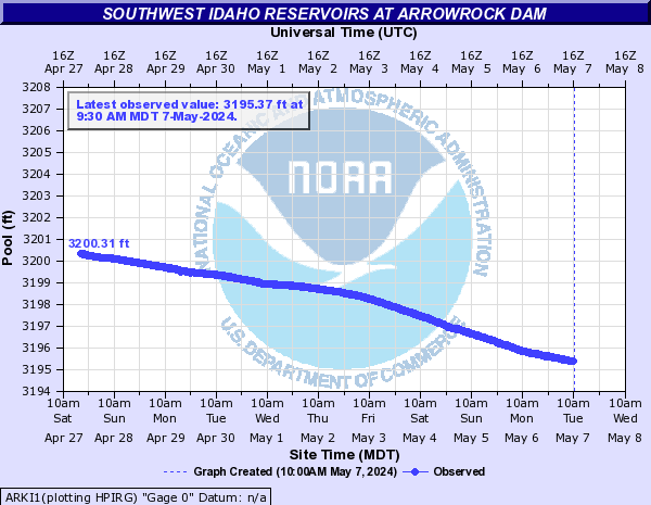
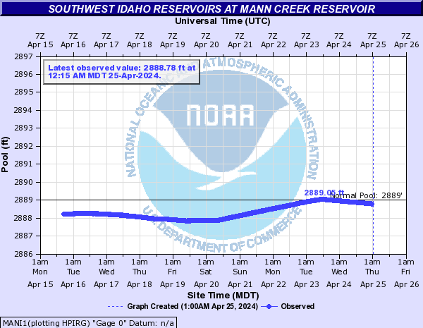
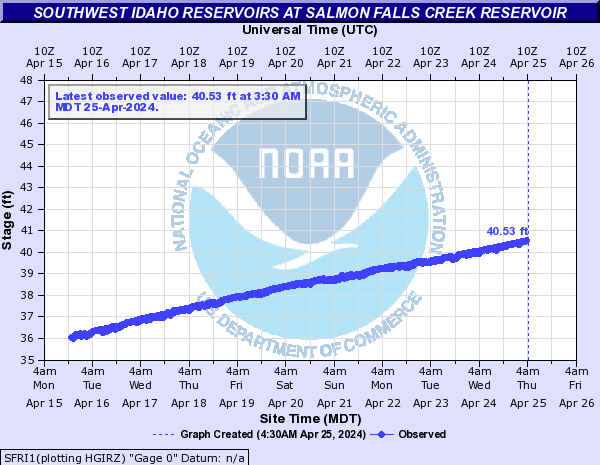
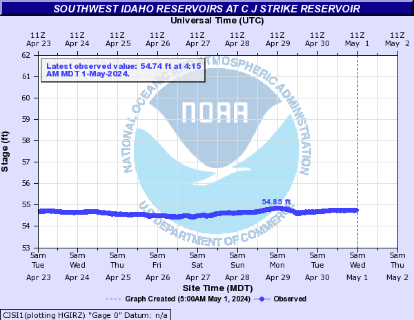
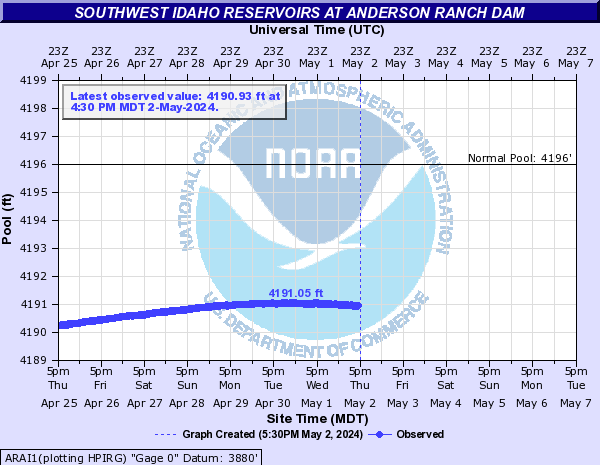
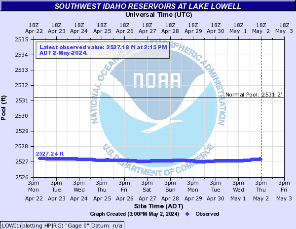
| Southwest Idaho Reservoir Trends | - | 3197.25 ft | +0.19 | - | - | - | - | - | - | - | 2888.45 ft | -0.1 | - | - | - | - | - | - | - | 44.71 ft | -0.01 | - | - | - | - | - | - | - | 54.82 ft | +0.09 | - | - | - | - | - | - | - | 4193.94 ft | +0.43 | - | - | - | - | - | - | - | 2529.02 ft | -0.06 | - | - | - | - | - | - | - | 5331.17 ft | +0.39 | 5333.66 | 5331.3 | 5331.59 | 5331.83 | 5332.13 | 5332.47 |
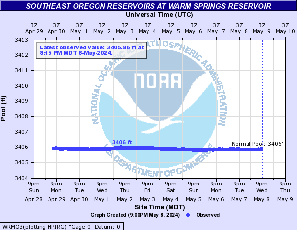
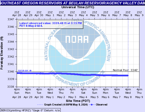
| Southeast Oregon Reservoir Trends | - | 2514.5 ft | -0.1 | - | - | - | - | - | - | - | 3405.88 ft | -0.01 | - | - | - | - | - | - | - | 3339.85 ft | -0.03 | - | - | - | - | - | - |
| Southwest Idaho Reservoirs | |||||||||
 | |||||||||
| Southeast Oregon Reservoirs | |||||||||
 | |||||||||