August 26, 2015 Flash Flood Event
By Aviva Braun
National Weather Service Boise, Idaho
Collaborators: Troy Lindquist, Dave Groenert, Stephen Parker, Josh Smith
Abstract
A moisture plume over the four corners region moved north and into our CWA on August 26th. Light winds in our region allowed a cluster of storms that developed over Camas and Elmore County to become nearly stationary. The system dropped over an inch of rain in some places, most notably over the 2013 Kelley burn scar. While reflectivities were not impressive, the areal coverage and lifespan of the system produced a flash flood event which caused a lot damage and put some people in danger. The amount of lightning produced by the storm cluster was admirable, but only caused one new fire (not far from the debris flow produced), probably due to the amount of rain received during the event. Model guidance was not the best at indicating the evening’s storm-type, but it did indicate the general location of storm activity.
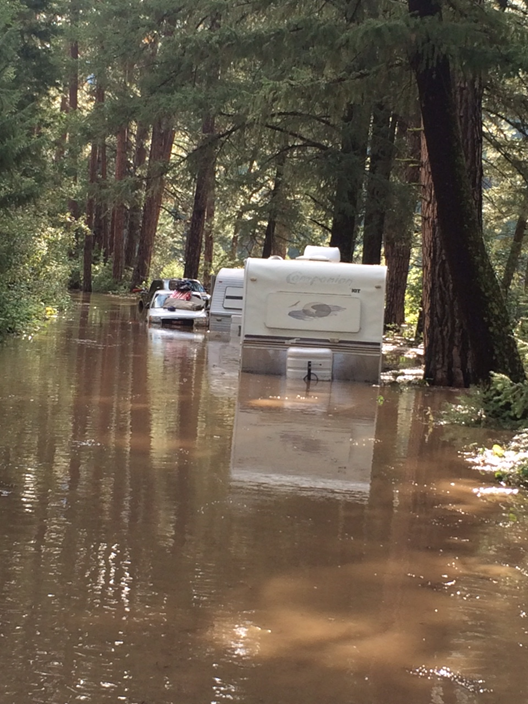
The August 26th flash flood event produced a debris flow which diverted the Boise River onto a road. The people in these trailers ended up trapped on this road until sun-up when they were finally able to get a hold of emergency personnel and get evacuated. We don’t see this often in our CWA, so it’s important to make a mental note that this kind of damage is possible and is recorded in Camas County.
Mike Gill, the Camas County Road and Bridge Supervisor, told us that this is the second year in a row in which a debris flow/s came off the Kelley Fire burn scar and briefly blocked and rerouted the channel of the South Fork Boise River. He also said that it may be another 4 to 5 years before this area completely recovers.
Part 1. What indication did we have the morning of the 26th that we would have a flash flood event that evening?
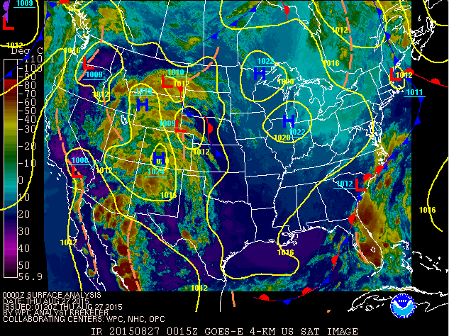
If you look at the IR imagery from the 26th at 18Z, we can see a moisture plume coming north out of the 4 corners region:
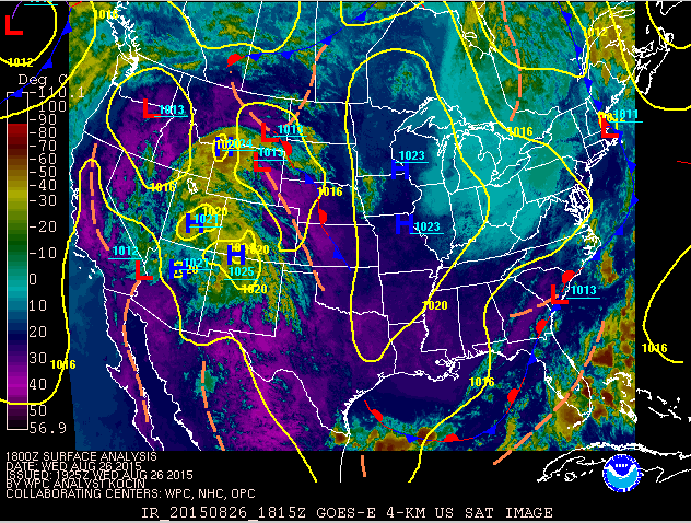
And the morning surface analysis from 18Z showed a low pressure center over the region:
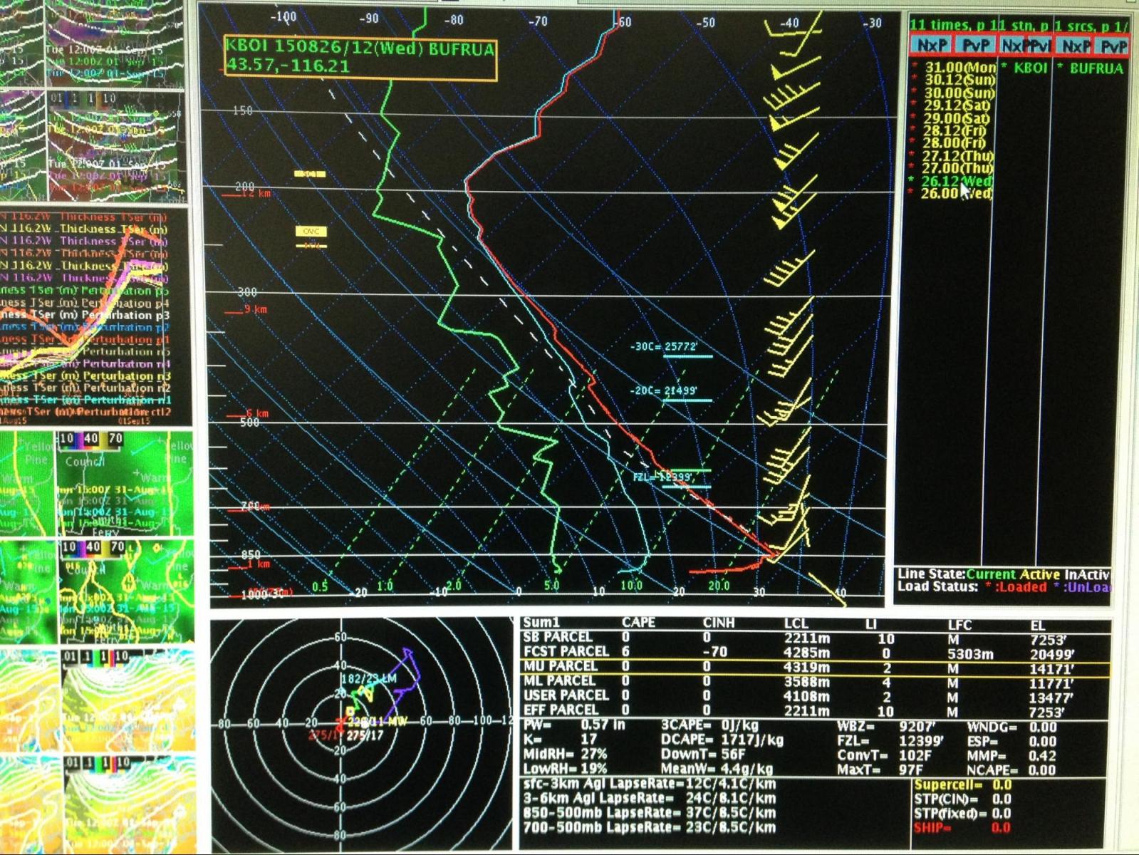
But Boise’s morning sounding (26 at 12Z) wasn’t impressive or telling:
Though, if anything were to develop here, they would likely be slow movers as storm-motion winds were lighter. Also note that in the reflectivity images to follow (Part 3b.), the storm seemed to back-build which could have contributed to the perception that this storm cluster was stationary.
Now, let’s think back to what we saw on the previous IR image and think about where Camas County is. We know that Fairfield, Idaho (in Camas Co.) is likely on the edge of the moisture plume and that Boise is not. What skew-T would be a better representation of what Fairfield’s area could possibly receive? Let’s take a look at the Salt Lake City skew-T.
Looking at the Salt Lake City morning sounding (26 at 12Z), we can see that there were in fact high PWs in this moisture plume. Note the light surface winds in this sounding as well.
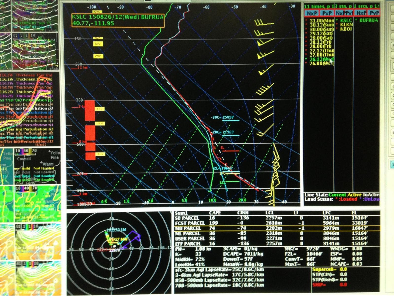
Could we see something develop later on the 26th? It certainly looks like there was potential.
Part 2. Model Guidance for that evening.
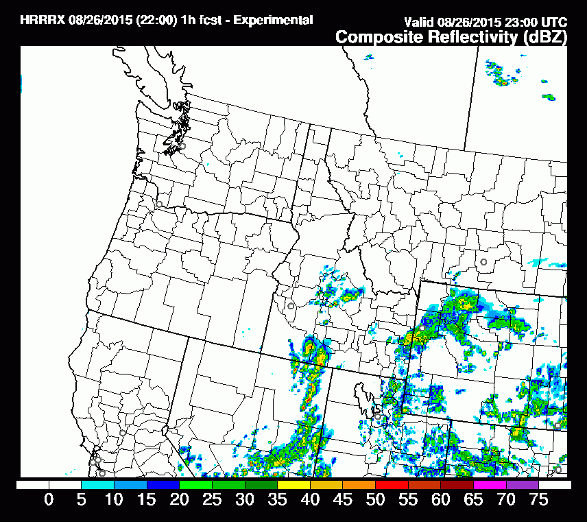
But model guidance didn’t give us any indication that the storms that would develop that evening would be slow movers and produce so much precip, as we would see in Camas County. In fact, what was represented in the HRRR (for example) produced some storms, but not the correct storm-type, though it did indicate development over the correct location, Camas County. The loop below is from the 26.22Z model run. It begins at 26/23Z and ends at 27/04Z. It is of the HRRR composite reflectivity:
Part 3a. What occurred the evening of August 26th?
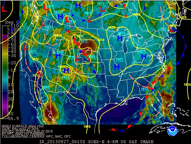
What did develop on the evening of the 26th was a nearly stationary cluster of storms that sat over Camas County (and the most Southeastern portion of Elmore County) and produced endless, heavy rain over that one area. Let’s look back at the progression of what we saw on IR (the first image is from the 27/00Z, the 2nd from 27/06Z):
In this image, you can see the storm cluster sitting over the West Central Mountains.
Because of the event’s long lifespan, a mesohigh formed due to the rain-cooled air. The mesohigh was visible on the 3hr pressure change plot (sorry I didn’t save this plot!). However, in this image, you see the aftermath of the cluster’s cold pool (look for the orange-dashed line over Idaho as the representation of the cold pool border).
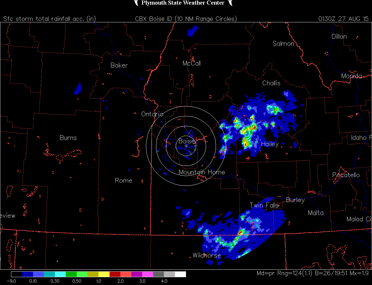
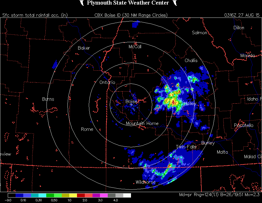
Part 3b. Radar imagery for the 26th.
Let’s take a look at the composite reflectivity loop (all Plymouth State loops are in two parts: the first plotted loop is from 27/01Z - 27/03Z, the second plotted loop is from 27/03Z - 27/05Z):
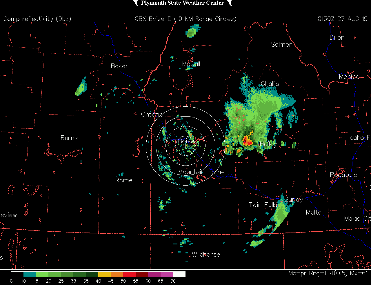
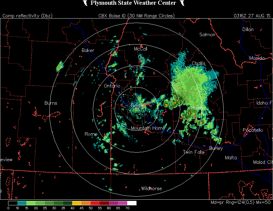
The cluster of storms sat over Camas County for several hours, dumping a lot of precip over a fragile burn scar (the Kelley Fire burn scar) and steep terrain.
Let’s look at the one-hour-precip loop:
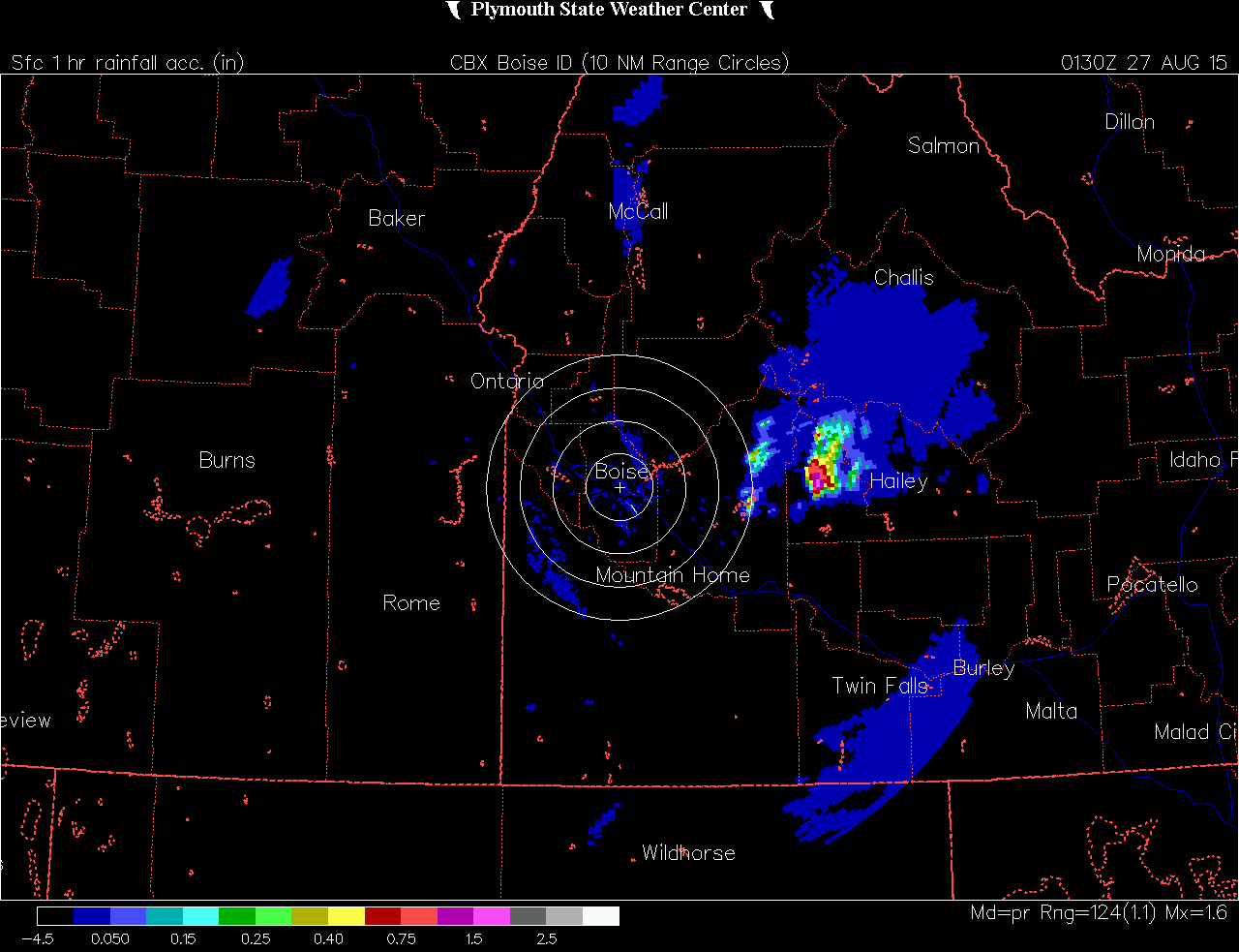
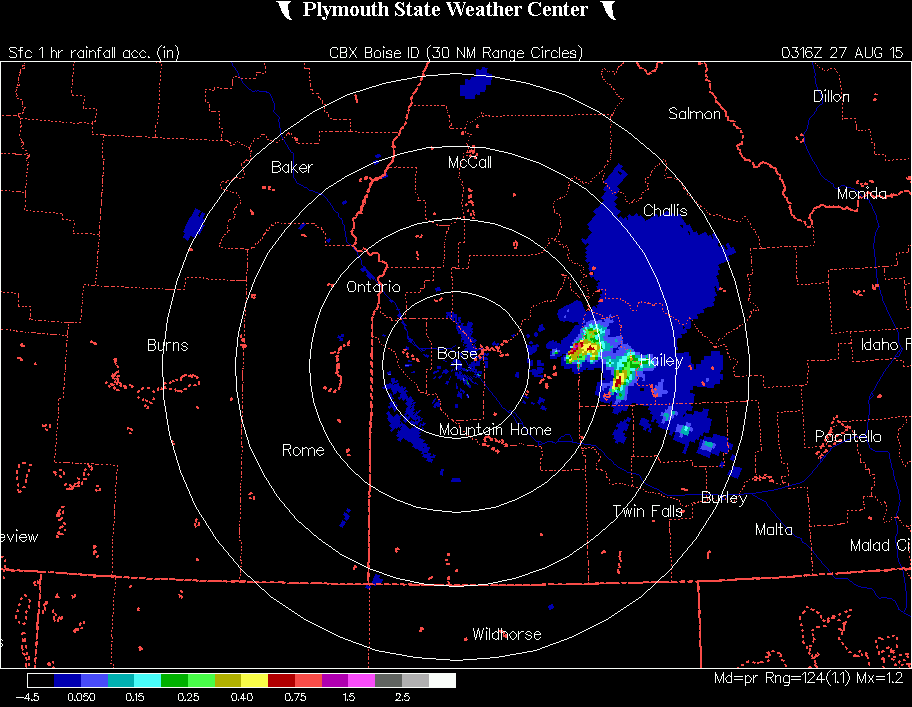
Radar didn’t show strong reflectivities, but it did show 1+ inches per hour in some areas on the OHP loop. Side note: as soon as we (the two of us on shift at the time, SP & AB) saw radar indicating 0.5 inches per hour (assuming that radar overestimates actual values), we issued the flash flood warning. It was sent out at 7:45 PM MDT and was active for 3 hours.
Storm total precip is also impressive and an indicator that this was going to be a big event:
Part 4. Storm outcome.
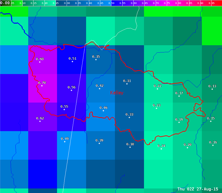
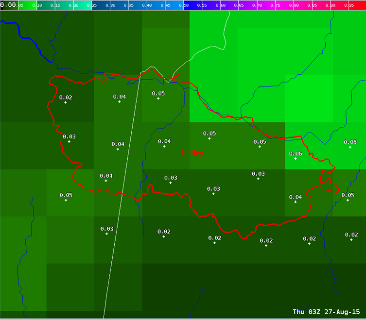
Looking back on 27/00Z-06Z obs grids for that evening (lightning and QPE):
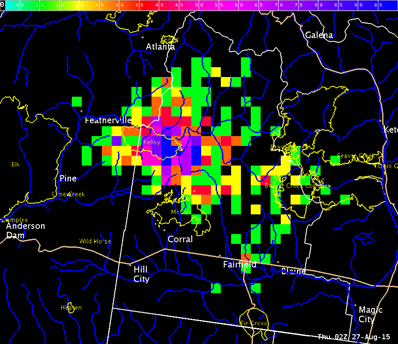
We observed an amazing amount of lightning over a localized area,
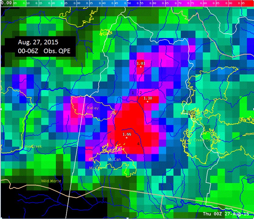
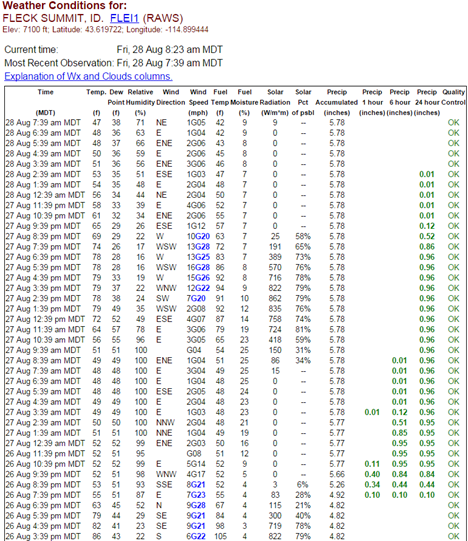
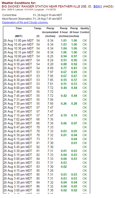
and an incredible amount of rain over the very same area. The 2013 fires are plotted on here. The debris flow this evening occurred over the NE portion of the Kelley scar. Also note the location of numbers 1 and 2 to the NE of the Kelley scar. 1 is the Fleck Summit observation site, and 2 is the Big Smokey Ranger Station observation site.
Here are readings from the two ground observation sites that are just northeast of the Kelley Fire that help tell the story:
Part 5. QPE analysis.
We should look back at what the radar was indicating in terms of OHP over the burn scar versus what was estimated to have fallen there. Unfortunately, we only have the OHP loop and not a still image, so this may be slightly difficult, however, we’ll try it.
Try to zero in on the high rainfall rates recorded by the radar along the Camas/Elmore County border (see figure below). That is approximately where the Kelley burn scar is located. The one-hour rainfall rates there seem to be around 0.6 - 1.1 inches.
Looking at estimated rainfall over the same period:
If we add the highest amounts of estimated data over the same period, we get a bit less than 0.75 inches. This seems in line with what the above ground observations were measuring. We can conclude then that radar estimates were close to accurate on August 26th. Halving what radar is telling us may be a good rule of thumb in general (the rule we used that night), but we should be aware that radar estimates could also be completely accurate! This may be because the Kelley scar is down-radial of beam blockage and therefore already has it’s radar estimates halved.
Part 6. The damage report.
We received many damage reports the next day, including two reports of debris flows that diverted the South Fork of the Boise River onto a road, trapping a few cars and RVs (with their owners inside) overnight. No injuries or deaths were reported however.
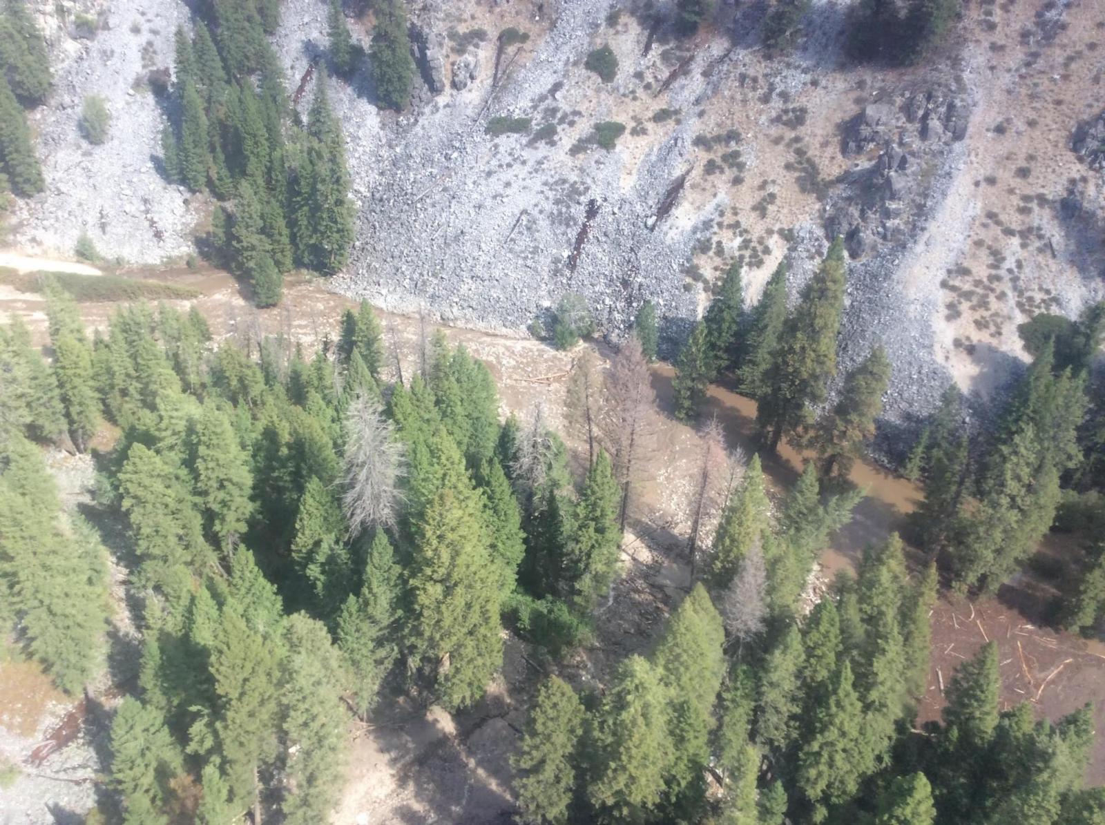
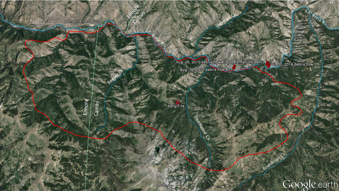
The 2013 Kelley burn scar has been a problem area in the past. In July 2014, there was a similar debris flow in the same area:
Here is a damage report written up by Troy Lindquist:
_____
Mike Gill, who works with Camas County Road and Bridge, provided the following bullets when we spoke this morning:
· This is being called the Boardman Incident, although the debris flows that blocked
the river did not come out of the Boardman Creek drainage.
· Two major debris flows blocked the river:
o #1 about 7 miles upriver from Baumgartner Campground
o #2 about 5.5 miles upriver from Baumgartner Campground.
· The debris flows left material up to feet deep on portions of F.S. Road 227 which
runs along the S.F. Boise River.
· The S.F. Boise River has worked its way around the debris and is flowing across
F.S. Road 227 in places.
· There were several smaller debris flows that came out of other drainages such as
Beaver Creek and Deadwood Creek.
· The USFS is trying to figure out how to get the river off of the road.
· Federal agencies recently met and declared that there are no funds/resources to fix
the road and river channel at the moment due to the ongoing fire situation.
· F.S. Road 227 is closed beginning about 2.5 miles east of Baumgartner
Campground and Mike Gill expects that it will remain closed at least until spring
2016.
This is the second year in a row in which a debris flow/s came off the Kelley Fire burn scar and briefly blocked and rerouted the channel of the S.F. Boise River. Mike Gill thought it'd be another 4 to 5 years before this area completely recovers.
___________
Part 7. Summary.
A moisture plume over the four corners region moved north and into our CWA on August 26th. Light winds in our region allowed a cluster of storms that developed over Camas and Elmore County to become nearly stationary. The system dropped over an inch of rain in some places, most notably over the 2013 Kelley burn scar. While reflectivities were not impressive, the areal coverage and lifespan of the system produced a flash flood event which caused a lot damage and put some people in danger. The amount of lightning produced by the storm cluster was admirable, but only caused one new fire (not far from the debris flow produced), probably due to the amount of rain received during the event. Model guidance was not the best at indicating the evening’s storm-type, but it did indicate the general location of storm activity.
What can we learn from this event?
There are several points to note here. First, look at where the incoming air-mass has originated and make sure to look up that area’s skew-T. This will give you a more accurate picture of what may develop. Second, model guidance may not always be accurate in storm-type, but it may be accurate in location of potential development. However, it could also be the other way around! Think to what you know about the day’s climate and decide the storm-type potential for yourself. Third, when there is potential for a rain event, make sure to plot burn scars in addition to flashy areas on our radar maps. Burn scars are just as sensitive to large rain events over brief periods as flashy areas. Lastly, be aware that beam blockage may give an accurate representation of what radar is telling us in its OHP output.

