Forecast Area
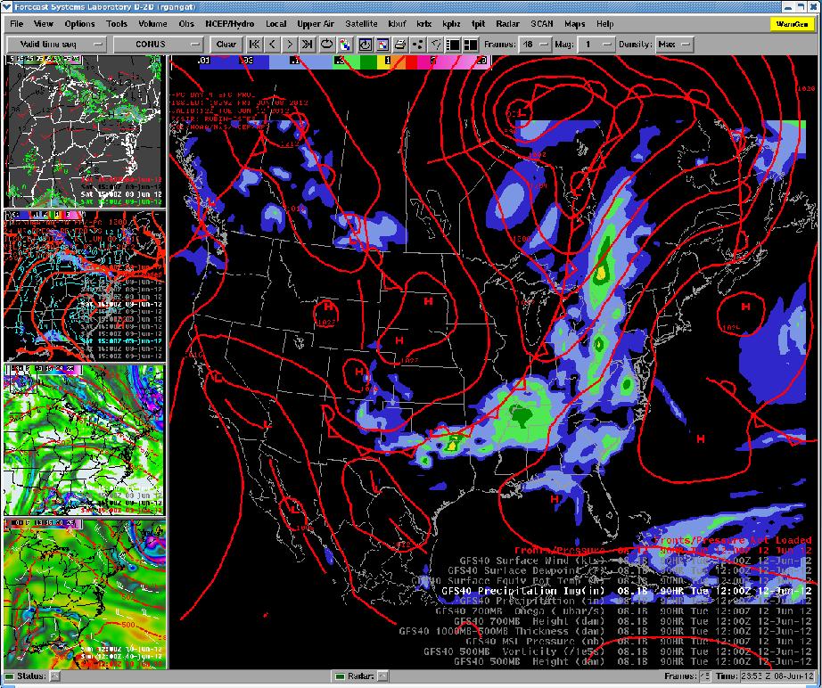
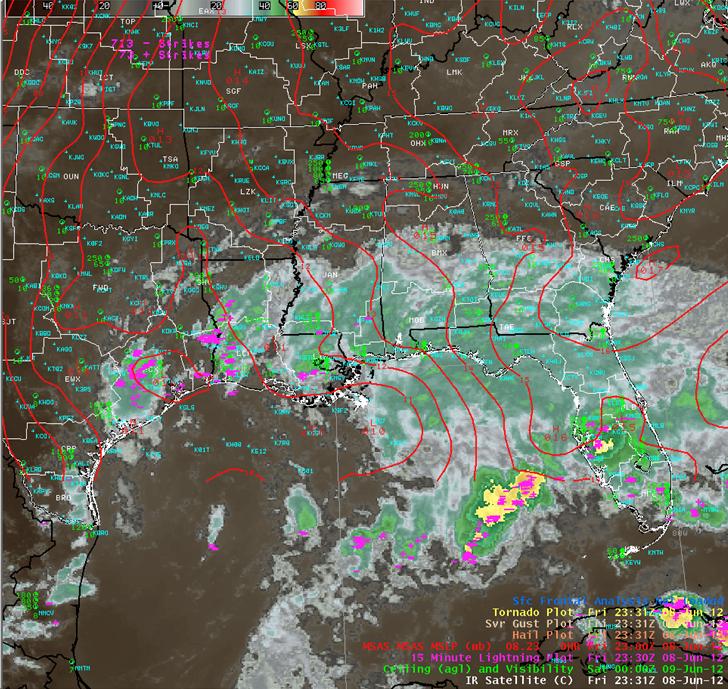
This is where forecasts for the area are made for land, air, and water, using the Advanced Weather Interactive Processing System (AWIPS), which is our mainframe computer system. It allows the forecast staff to analyze computer forecast guidance, otherwise know as "computer models", in 4 dimensions (along the Earth's surface as well as with respect to height and time), and overlay this data with satellite, radar, and local weather reports. An example of a typical AWIPS graphic workstation screen can be seen (below, left). In the big pane is computer model data. The screen is interactive, allowing the forecaster to load and display the desired fields, or compare the same parameters between several computer models. There are four smaller panes in which any item or combination of items can be stored for later viewing. For instance, (below, right) is an overlay of an enhanced, infrared satellite imagery, surface observations, mean sea level pressure, and 15 minute lightning plot.
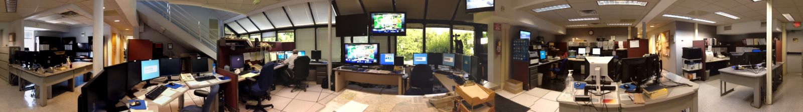
In the image to the bottom is the forecast operations center. The center of the picture is called our Situational Awareness Display (SAD). This consists of three TV screens that usually have on either the Weather Channel, local or national news, or displays of current weather maps (mesoscale analyses). In the picture, a total of 6 computer work statations can be seen. Any forecast that needs to be complete can be accomplished from any of these workstations. On the far right, the work station is usually operated by the Hydrologist. Working at that workstation can be convenient for the Hydrologist because a great number of hydrology binders, books, and any information relating to hydrology is located behind the workstation for reference. The workstation on the left of the hydrology area (second from the right) is usually where the Hydrometeorological Technician (HMT) works. At this station, the worker answers phone calls, prepares and launches the weather balloon, and monitors river stages. The remaining 4 workstations are usually operated by General or Lead Forecasters working on the aviation, short term, or long term forecasts. Terminal forecasts (called TAFs) and route forecasts are composed for aviation purposes. These products are issued every 6 hours, and updated as needed. This forecaster might also be responsible for writing fire weather forecasts and Short Term Forecasts as the weather requires. "Short fused" warnings for Severe Thunderstorms, Tornadoes, and Flash Floods, are the responsibility of this person as well. On active weather days, additional staff would be on hand or called in to assist with all these duties. The warning process is explained in greater detail under the radar operations section of this tour.
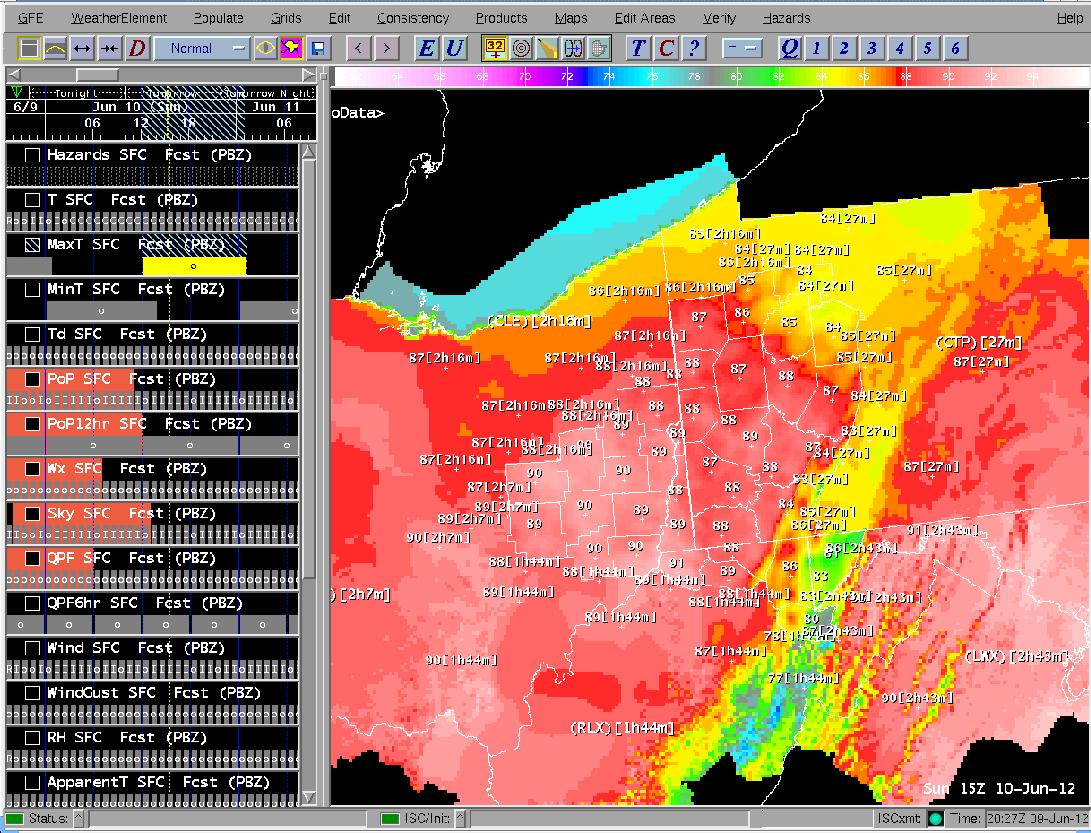
The long term, or public, forecast is operated by the other forecaster on shift. This person composes the 7-day forecast traditionally distributed via radio and other media sources. "Longer fused" items, such as winter storm watches/warnings, windchill or heat advisories/warnings, and flood watches - to name a few - would be the responsibility of this person. All of the forecast products are generated by the forecaster using AWIPS. The forecaster interaction with the system is performed through a set of digital grids made in a program called Graphical Forecast Editor (GFE) (see graphic below). The grids can be viewed online on our webpage. These fields are then adjusted by the forecaster based on meteorological principles and forecaster experience. Many of our text products are by-products of the digital grids. Our 7day zone forecast text product and the text digital product are a couple of examples.
When "long fused" warnings, watches, or advisories need to be issued, AWIPS contains an application program to accomplish this task as well. These items are then displayed on a map. This map displays, not only the area served by our forecast office, but also areas covered by surrounding offices, similar to what you see above. This way, offices can more readily coordinate the forecast with each other. AWIPS software can recognize any watches, warnings, or advisories in effect, and will break apart groups, if necessary, and insert the appropriate headline in the forecast products

