The snow was not the only problem with this storm as strong northwest winds buffeted the region producing blowing and drifting snow that closed most roads for a time across southeast Minnesota and northeast Iowa. Near white-out conditions also occurred for short periods in the open rural areas.
Snow continued to fall into Friday, March 2nd as the storm moved into eastern Wisconsin and eventually across Lake Michigan. Drifting snow continued to be a problem but the blowing snow and near white-out conditions subsided as the winds slowly decreased. The storm finally released its grip on the region Friday night.
This snowfall combined with the snow that fell from February 23-26 created a blanket of snow ranging in depth from around a foot up to two and a half feet. These two storms also put La Crosse into the record books with the most snow ever recorded over a 7 day period. The top three snowiest 7 day periods for La Crosse are:
|
Rank |
Snowfall Amount |
Week Ending |
|
1 |
27.4 |
3/2/2007 |
|
2 |
23.5 |
1/29/1996 |
|
3 |
22.7 |
12/7/1997 |
The second major winter storm in less than a week took aim at the upper Midwest and delivered two rounds of winter precipitation to the area as the calendar turned to March. The storm took shape over the southern Plains states Wednesday February 28th and then started to move northeast toward the area. As it did, the first round of precipitation moved into the region that afternoon. Light to at times moderate snow fell through Wednesday night with totals ranging from just a trace to around 3 inches. As the storm moved into Missouri Thursday March 1st, dry air began to wrap into the system and the precipitation become more scattered across the immediate region while a heavy snow band set up from eastern Nebraska and western Iowa into southwest and south central Minnesota. Along with the dry air, warm air aloft also spread over the area which created a mixed bag of winter precipitation. Light rain was common across parts of northeast Iowa into southwest Wisconsin where temperatures warmed above freezing. Farther north, temperatures remained below freezing setting the stage for snow, sleet and freezing rain to fall. Ice accumulations of 1/8 to 1/4 of an inch were reported from Wabasha and Winona counties in Minnesota and across parts of Trempealeau, Clark, Monroe and Adams counties in western and central Wisconsin. Temperatures once again fell below freezing across the entire Thursday night as the low slowly moved northeast into southern Wisconsin. This allowed all the precipitation to change back over to snow and some of this was quite heavy from southeast Minnesota into north central Wisconsin. Storm totals in excess of 10 inches were common in these areas.
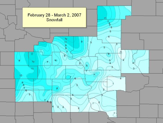
Storm Total Snowfall through Friday morning, March 2nd:
PUBLIC INFORMATION STATEMENT
NATIONAL WEATHER SERVICE LA CROSSE WI
252 PM CST FRI MAR 2 2007
...WINTER STORM TOTAL SNOWFALLS THROUGH FRIDAY MORNING...
...FEBRUARY 28 THROUGH MARCH 2...
LOCATION COUNTY STATE SNOWFALL
CLAREMONT DODGE MN 11.5
BYRON OLMSTED MN 11.2
ORONOCO OLMSTED MN 11.1
MANTORVILLE 1E DODGE MN 11.0
MONDOVI 6S BUFFALO WI 11.0
ROCHESTER AIRPORT OLMSTED WI 10.7
BYRON 3N OLMSTED MN 10.4
MCINTIRE 3E HOWARD IA 10.0
SPRING VALLEY FILLMORE MN 10.0
GRAND MEADOW MOWER MN 9.9
THEILMAN 1SSW WABASHA MN 9.7
DODGE CENTER DODGE MN 9.0
INDEPENDENCE 3NW TREMPEALEAU WI 9.0
READS LANDING 1W WABASHA MN 9.0
ZUMBRO FALLS WABASHA MN 8.9
SPILLVILLE WINNESHIEK IA 8.5
SPRING GROVE HOUSTON MN 8.5
ELGIN 2SSW WABASHA MN 8.3
OWEN 2N CLARK WI 8.3
NEW HAMPTON CHICKASAW IA 8.0
UTICA WINONA MN 8.0
WARRENS 5WSW MONROE WI 8.0
CHASEBURG 2S VERNON WI 7.8
PRESTON FILLMORE MN 7.8
ALTURA 5W WINONA MN 7.4
LA CROSSE NWS LA CROSSE WI 7.2
OSAGE MITCHELL IA 7.1
CALEDONIA HOUSTON MN 7.0
CRESCO 1NE HOWARD IA 7.0
ELMA HOWARD IA 7.0
GALESVILLE 1S TREMPEALEAU WI 7.0
HAMMOND 1S WABASHA MN 7.0
OSSEO TREMPEALEAU WI 7.0
ROCK DAM CLARK WI 7.0
WABASHA WABASHA MN 7.0
BLAIR TREMPEALEAU WI 6.9
CHATFIELD 4W FILLMORE MN 6.5
WINONA WINONA MN 6.5
GOODRICH TAYLOR WI 6.0
HARMONY FILLMORE MN 6.0
LANSING 4SE ALLAMAKEE IA 6.0
RENO 3SW HOUSTON MN 6.0
WESTBORO TAYLOR WI 6.0
CALMAR WINNESHIEK IA 5.9
STODDARD 3NE VERNON WI 5.8
WESTBY VERNON WI 5.8
COLBY CLARK WI 5.6
HOLMEN 2S LA CROSSE WI 5.6
DORCHESTER ALLAMAKEE IA 5.5
ETTRICK TREMPEALEAU WI 5.5
TUNNEL CITY 1S MONROE WI 5.2
TAYLOR JACKSON WI 5.0
WEST SALEM LA CROSSE WI 5.0
VIROQUA VENRON WI 4.9
LA CROSSE LA CROSSE WI 4.8
CHARLES CITY FLOYD IA 4.7
BIG FLATS ADAMS WI 4.5
FORT ATKINSON WINNESHIEK IA 4.5
LA CRESCENT 1N HOUSTON MN 4.5
POSTVILLE ALLAMAKEE IA 4.0
COON VALLEY VERNON WI 3.5
OELWEIN 1E FAYETTE IA 3.3
ELKADER CLAYTON IA 3.0
HILLSBORO VERNON WI 2.8
MARQUETTE 3W CLAYTON IA 2.8
PLATTEVILLE GRANT WI 2.7
PRAIRIE DU CHIEN CRAWFORD WI 2.6
STEUBEN 4SE CRAWFORD WI 2.6
ELGIN FAYETTE IA 2.5
GAYS MILLS CRAWFORD WI 2.4
EDGEWOOD CLAYTON IA 2.0
VOLGA CLAYTON IA 2.0
ELKADER 6SSW CLAYTON IA 1.6
FAYETTE FAYETTE IA 1.6
RICHLAND CENTER RICHLAND WI 1.3
CUBA CITY GRANT WI 1.0
READSTOWN VERNON WI 1.0
OBSERVATIONS ARE COLLECTED FROM A VARIETY OF SOURCES WITH VARYING
EQUIPMENT AND EXPOSURE. NOT ALL DATA LISTED IS CONSIDERED OFFICIAL.
$$
Ice reports from Thursday - March 1, 2007:
PRELIMINARY LOCAL STORM REPORT
NATIONAL WEATHER SERVICE LA CROSSE WI
346 PM CST THU MAR 01 2007
..TIME... ...EVENT... ...CITY LOCATION... ...LAT.LON...
..DATE... ....MAG.... ..COUNTY LOCATION..ST.. ...SOURCE....
..REMARKS..
0249 PM ICE STORM ARKDALE 44.03N 89.88W
03/01/2007 ADAMS WI PUBLIC
1/8 INCH OF ICE ACCUMULATION FROM FREEZING RAIN.
0249 PM ICE STORM FRIENDSHIP 43.97N 89.82W
03/01/2007 ADAMS WI CO-OP OBSERVER
1/8 INCH OF ICE ACCUMULATION FROM FREEZING RAIN. GLAZE
ICE.
0302 PM ICE STORM STRUM 44.55N 91.39W
03/01/2007 TREMPEALEAU WI LAW ENFORCEMENT
1/8 INCH OF ICE ACCUMULATION IN NORTHERN PART OF COUNTY.
0302 PM ICE STORM WINONA 44.05N 91.66W
03/01/2007 WINONA MN EMERGENCY MNGR
1/4 INCH OF ICE ACCUMULATION FROM SLEET AND FREEZING
RAIN. SCHOOL BUSES NOT ABLE TO GET UP THE RIDGES.
0302 PM ICE STORM TOMAH 43.99N 90.50W
03/01/2007 MONROE WI LAW ENFORCEMENT
1/8 INCH OF ICE ACCUMULATION. CARS HAVING TROUBLE GETTING
UP HILLS COUNTYWIDE.
0310 PM ICE STORM WABASHA 44.37N 92.05W
03/01/2007 WABASHA MN LAW ENFORCEMENT
1/8 INCH OF ICE ACCUMULATION THROUGH THE COUNTY. NO MAJOR
PROBLEMS.
0310 PM ICE STORM NEILLSVILLE 44.56N 90.59W
03/01/2007 CLARK WI LAW ENFORCEMENT
1/8 INCH OF ICE ACCUMULATION THROUGH CLARK COUNTY.
&&


 Follow us on YouTube