| What is it?
The Cooperative Weather Observer Program is a national organization run by the National Weather service and has been in existence and virtually unchanged for well over 100 years. It consists of over 11,000 volunteers nationwide who record weather information on a daily basis. Not only daily temperatures and precipitation, but in some cases soil temperatures, snow depth, river stages, and agricultural data. The data is used to support daily weather forecasts and warnings, and it continues to help build the nation’s historic climate record. Access to the CO-OP data, helpful instructions, and a lot more information can be found on the National Weather Service's Cooperative Observer page. |
|
What do they do?
The volunteer observers take temperature and precipitation measurements on a daily basis, using equipment supplied and maintained by the National Weather Service. They then send the data in, either daily or monthly, to their local weather service office where it used and/or transmitted to other government agencies and media outlets.
At month's end, all the data is sent to the National Climatic Data Center (NCDC) where is it quality controlled, put on computer, and then achieved.
Who uses the information?
Climatologists and researchers are probably the biggest users of the information. The data that is compiled from the observers provide an invaluable data set that can lead to better understanding of droughts, floods, heat waves, and cold snaps.
Historical weather averages and normals for all areas of the country are determined using observer data. Observer data help settle billions of dollars annually in insurance and legal claims, determine federal disaster declarations for federal aid to local counties and are a major factor in determining household energy costs. These data play a critical role in efforts to determine and evaluate the extent of climate change from local to global scales. In addition, data collected by weather observers help local officials make long-term planning decisions about water resources and are used by a variety of industries on a daily basis, including medical, transportation, agriculture, engineering and communication.
What kind of equipment is used?
There are four basic types of equipment that the cooperative observer users:
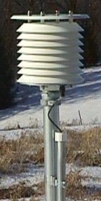
Max/Min temperature system (MMTS): This unit measures the temperature outside and keeps track of the daily maximum and minimum temperature for the day.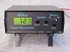 |
 |
8 inch rain gauge: This piece of equipment consists of one 8 inch in diameter metal cylinder, along with a smaller width plastic cylinder that is placed inside of that. A funnel is then placed on top of the metal cylinder and any precipitation that falls is then funneled into the smaller cylinder and can then be measured from there for the daily or 24 hour total. This inner plastic tubing cannot be used during the winter. | 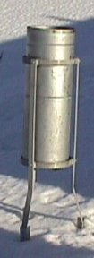 |
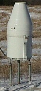
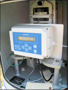
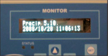
| Fisher & Porter Rain Gauge and Sutron Data Logger: This is another, much larger precipitation recorder. It is an encased piece of equipment that had a large opening on top to collect the precipitation. The precipitation falls into a bucket that rests on the load cell that bends with increased weight. This weighing sensor is very sensitive and can detect changes of one hundredth of an inch of precipitation in a matter of several seconds. The data logger then records the information as fifteen minute blocks, based on weighing sensor measurements. The data from this rain gauge is currently downloaded to an SD card by the observer once a month and then mailed or e-mailed to the NWS. This data is checked for quality and completeness and sent to the National Climatic Data Center where it undergoes more quality checks before being published as part of the official climate data for the United States. This is a year-round recording device. |
|
|||
| Cotton Region Shelter: This temperature shelter houses the maximum and minimum thermometers. This shelter has been phased out in favor of the MMTS. However, the shelter will remain the source for high and low temperatures for stations that currently use them to keep some continuity to their records. | 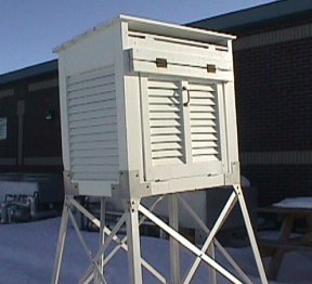 |
History
| An act of Congress in the 1890's established not only the Weather Bureau (which is today's National Weather Service), but also the first extensive network of cooperative observing sites. Many of those stations were in operation long before that however.
John Companius Holm's weather records, taken without the benefit of instruments in 1644 and 1645, were the earliest known observations in the United States. Other notable record keepers were Thomas Jefferson, who kept an almost unbroken string of records from 1776 to 1816, George Washington, and Benjamin Franklin. In fact, two of the most prestigious awards given to Cooperative Weather Observers are named after Holm and Jefferson. |
 |
Interested?
Does becoming a volunteer weather observer interest you? There are some locations currently devoid of spotters, plus there are occasionally some openings in other areas as current Cooperative Observers "retire" from their service. Drop us an email (or write us) if you think this is something you would like to do, or to get more information on what the Cooperative Observer Program is all about.
|
Precipitation
|
Snow
|
Temperature
|
Soil Temp
|
15 min Pcpn
|
River Stage
|
|
| Wisconsin | ||||||
| ALMA DAM 4 |
x
|
x
|
x
|
|
x
|
x
|
| BLACK RIVER FALLS |
x
|
x
|
|
|
x
|
|
| CASHTON 3 NNW |
x
|
x
|
x |
|
|
|
| CUBA CITY |
x
|
x
|
|
x
|
|
|
| FRIENDSHIP |
x
|
x
|
x
|
|
x
|
|
| GAYS MILLS |
x
|
x
|
x
|
|
|
|
| GENOA DAM 8 |
x
|
x
|
x
|
|
x
|
x
|
| LA CROSSE 4 NNW |
x
|
x
|
|
|
|
|
| LA CROSSE MUNICIPAL AIRPORT |
x
|
x
|
x
|
|
x
|
|
| LA CROSSE WFO |
x
|
x
|
x
|
x
|
|
|
| LA FARGE |
x
|
x
|
|
|
x
|
x
|
| LANCASTER 4 WSW |
x
|
x
|
x
|
|
x
|
|
| LYNXVILLE DAM 9 |
x
|
x
|
x
|
|
x
|
x
|
| MATHER 3 NW |
x
|
x
|
x
|
|
|
|
| MAUSTON 1 SE |
x
|
x
|
x
|
|
|
|
| MEDFORD |
x
|
x
|
x
|
|
x
|
|
| MONDOVI |
x
|
x
|
x
|
|
|
|
| NEILLSVILLE 3 ESE |
x
|
x
|
x
|
x
|
|
|
| ONTARIO 3E |
x
|
x
|
|
|
|
|
| OWEN 1E |
x
|
x
|
x
|
|
|
|
| PRAIRIE DU CHIEN |
x
|
x
|
x
|
|
|
|
| SPARTA |
x
|
x
|
x
|
|
|
|
| STEUBEN 4 SE |
x
|
x
|
|
|
|
|
| STRUM 4 S |
|
|
|
|
x
|
|
| TOMAH RANGER STATION |
|
|
|
|
x
|
|
| TREMPEALEAU DAM 6 |
x
|
x
|
x
|
|
x
|
x
|
| VIROQUA |
x
|
x
|
x
|
|
|
|
| WILLARD |
|
|
|
|
x
|
|
| Minnesota | ||||||
| ALTURA 5 W |
x
|
x
|
|
|
|
|
| AUSTIN WWTF |
x
|
x
|
x
|
|
|
|
| CALEDONIA |
x
|
x
|
x
|
|
|
|
| DODGE CENTER |
|
|
|
|
x
|
|
| ELGIN 2 SSW |
x
|
x
|
|
|
|
|
| GRAND MEADOW |
x
|
x
|
x
|
|
|
|
| HARMONY |
x
|
x
|
|
|
|
|
| HOKAH 4 NW |
x
|
x
|
|
x
|
|
|
| LA CRESCENT DAM 7 |
x
|
x
|
|
x
|
x
|
|
| LAKE CITY |
x
|
x
|
|
|
|
|
| MINNESOTA CITY DAM 5 |
x
|
x
|
|
|
|
x
|
| PRESTON |
x
|
x
|
x
|
x
|
|
x
|
| ROCHESTER INTERNATIONAL AIRPORT |
x
|
x
|
x
|
|
x
|
|
| ROCHESTER AP 2 NE |
x
|
x
|
|
|
|
|
| RUSHFORD |
x
|
x
|
x
|
|
x
|
|
| SPRING GROVE 4N |
x
|
x
|
|
|
x
|
|
| SPRING VALLEY |
x
|
x
|
|
|
x
|
|
| THEILMAN 1 SSW |
x
|
x
|
x
|
|
|
|
| WABASHA |
x
|
x
|
|
|
|
|
| WINONA DAM 5 A |
x
|
x
|
x
|
|
|
x
|
| Iowa | ||||||
| CALMAR |
x
|
x
|
|
|
x
|
|
| CHARLES CITY |
x
|
x
|
x
|
|
|
|
| CLERMONT |
|
|
|
|
|
x
|
| DECORAH |
x
|
x
|
x
|
|
|
|
| ELKADER 6 SSW |
x
|
x
|
x
|
|
|
|
| ELMA |
x
|
x
|
|
|
|
|
| FAYETTE |
x
|
x
|
x
|
|
|
|
| GUTTENBERG L AND D 10 |
x
|
x
|
x
|
|
|
x
|
| IONIA 2 W |
x
|
x
|
x
|
|
|
|
| MCGREGOR |
|
|
|
|
x
|
|
| NASHUA 2 SW |
x
|
x
|
|
x
|
|
|
| NEW HAMPTON |
x
|
x
|
x
|
|
|
|
| OELWEIN 1 E |
x
|
x
|
x
|
|
|
|
| OSAGE |
x
|
x
|
x
|
|
|
|
| POSTVILLE |
x
|
x
|
x
|
|
|
|
| ST ANSGAR |
x
|
x
|
|
|
x
|
|
| STRAWBERRY POINT |
X
|
X
|
|
|
x
|
|
| WAUCOMA 1WNW |
x
|
x
|
|
|
|
|


 Follow us on YouTube