Below are some Independence Day weather statistics for La Crosse, WI, and Rochester, MN.
La Crosse, WI:
The following statistics comprise 151 years of data. From 1873 through 1950, the data came from various locations in downtown La Crosse. Since 1950, the data has been gathered at La Crosse Regional Airport.
Independence Day in La Crosse, WI
(Period of Record 1873-2023) |
|
1991-2020 Normals (July 4th)
|
Records
|
| Maximum Temperature |
85°
|
Warmest High Temperature |
103°
|
July 4, 2012
|
| Coldest High Temperature |
62°
|
July 4, 1967
|
| Minimum Temperature |
64°
|
Warmest Low Temperature |
81°
|
July 4, 2012
|
| Coldest Low Temperature |
44°
|
July 4, 1967
|
| Average Temperature |
75°
|
Warmest Average Temperature |
92.0°
|
July 4, 2012
|
| Coldest Average Temperature |
53.0°
|
July 4, 1967
|
| Precipitation |
0.14"
|
Wettest |
1.39"
|
July 4, 1913
|
While Independence Day is often thought to be hot, temperatures have only climbed to 90° or higher 27 times (17.9%) and to 100° or higher 2 times (1.3%). The only two Independence Days in which the high temperature has reached or exceeded 100° were 1911 (100°) and 2012 (103°).
The odds of having any rain on Independence Day are 47.7% (72 out of 151). There has been measurable precipitation (0.01" or greater) on 60 Independence Days (39.7%) and trace amounts (less than 0.01") on 12 Independence Days (7.9%).
During last year's Independence Day, the high temperature was 87°F and the low temperature was 65°F. A total of 0.24" of rain fell. This was the second consecutive Independence Day in which rain has fallen. It has only rained on 5 out of the last 14 Independence Days (2010, 2013, 2018, 2022, & 2023). The average wind speed was 6.4 mph.
Rochester, MN:
The following statistics comprise 112 years of data. From 1916 through 1931, the data came from several cooperative observers in the Rochester area. Since 1932, the data has been gathered at Rochester International Airport. No data was taken on Independence Day from 1889 to 1891 and from 1921 to 1928.
Independence Day in Rochester, MN
(Period of Record 1886-2023) |
|
1991-2020 Normals (July 4th)
|
Records
|
| Maximum Temperature |
81°
|
Warmest High Temperature |
98°
|
July 4, 1949
|
| Coldest High Temperature |
60°
|
July 4, 1967
|
| Minimum Temperature |
61°
|
Warmest Low Temperature |
75°
|
July 4, 2012
|
| Coldest Low Temperature |
43°
|
July 4, 1972
July 4, 1967
|
| Average Temperature |
71°
|
Warmest Average Temperature |
86.0°
|
July 4, 1949 |
| Coldest Average Temperature |
51.5°
|
July 4, 1967
|
| Precipitation |
0.14"
|
Wettest |
1.40"
|
July 4, 1913
|
While Independence Day is often thought to be hot, temperatures have only climbed to 90 degrees or higher 12 times (10.7%). The last time was in 2012 (93°).
Twenty out of the last 28 Independence Days have been dry. The last time it rained was back in 2022 (0.41" - 9th wettest Independence Day). The odds of having any precipitation on Independence Day are 43.8% (49 out of 112). There has been measurable precipitation (0.01" or greater) on 37 Independence Days (33%) and trace amounts (less than 0.01") on 12 Independence Days (10.7%).
During last year's Independence Day, the high temperature was 84°, the low temperature was 63°, and no rain fell. The average wind speed was 10 mph.
 |
Independence Day
Weather History
|
|
The following weather events affected southeast Minnesota, northeast Iowa, and western Wisconsin on Independence Day:
- In 1901 - between two and four inches of rain fell from southeast Minnesota northeast into northern Lower Michigan and Upper Michigan. Some of the heaviest totals included: Neillsville, WI (3.80"), St. Charles, MN (3.43"), and Caledonia, MN (3.10").
- In 1907 - Neillsville, WI received 3.50 inches of rain.
- In 1911 - much of the Upper Mississippi River Valley was in the midst of a heatwave that began on July 1st and continued into July 5th. Osage, IA reached 103° on Independence Day. This was their hottest temperature ever recorded. Other locations that reached 100 degrees on July 4th included:
- In Western Wisconsin: La Crosse (100°), Lancaster (100°), Muscoda (101°), and Viroqua (102°)
- In Southeast Minnesota: Grand Meadow (102°)
- In Northeast Iowa: Charles City (104°), Decorah (104°), Elkader (104°), Elma (102°), Fayette (103°), Mason City (104°), and New Hampton (104°).
- In 1912 - Hatfield, WI received 3.50" inches of rain.
- In 1967 - Decorah, IA (41°), Elkader, IA (46°), and Genoa, WI (46°) recorded their coldest July temperature.
- In 1972 - Blair, WI (36°) and Jump River, WI (27°) had their coldest July temperature. Also, Jump River has the coldest temperature ever recorded in July for Wisconsin.
- In 1994 - a series of squall lines with severe thunderstorms produced five tornadoes and violent wind gusts to 77 mph. A tornado set down in Dickeyville (Grant County) and traveled three miles damaging five homes, two sheds, and two farms. Damage was about $200,000. A small tornado caused $100,000 damage to a house, two outbuildings, and nine cars just southeast of Woodford (Lafayette County). A tornado skipped along an eight-mile path starting two miles northwest of Prairie du Sac (Sauk County), moving northeast along Highway 78, crossing the Wisconsin River into Columbia County along Highway 188, then crossed back into Sauk County at Highway 113 and entered Merrimac. Damage was estimated at $760,000 to 60 homes in Merrimac, and to a fertilizer plant and Dairy Forage Center in Prairie du Sac. Tornadoes briefly touched down but caused no damage four miles west of Fremont (Waupaca County) and 1.5 miles north of Oregon (Dane County). The intense winds knocked down numerous trees and power lines and caused other property damage mainly to sheds and outbuildings.
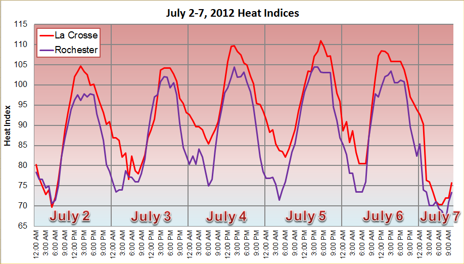
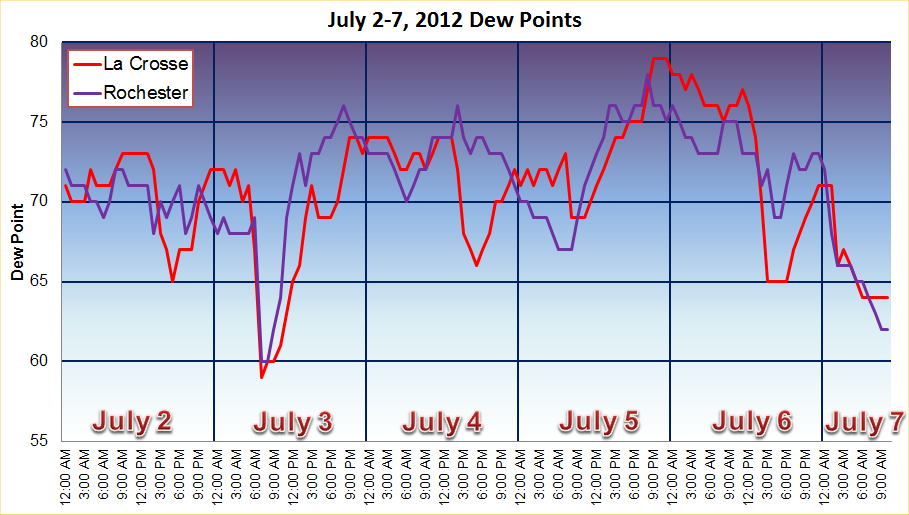
- In 2012 - much of the Upper Mississippi River Valley was in the midst of a heatwave that began on July 2nd and continued into July 6th. Many locations (38 record highs) had their warmest Independence Day ever recorded. The following locations topped the century mark: Northeast Iowa: Guttenberg (100°) and Oelwein (102°) and Western Wisconsin: Boscobel (103°), Genoa Dam (101°), La Crosse (103°), Sparta (102°),
When the high humidity was factored in, afternoon and early evening heat indices ranged from 100 to 115. Heat Advisories were in effect July 2nd for portions of the region, with Excessive Heat Warnings covering much of the Upper Mississippi River Valley from July 3rd through July 6th.
|
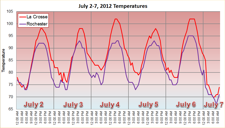
Temperatures
|
Dew Points
|
Heat Indices
|
Tragically, the extreme heat also was deadly as several people lost their lives from heat related factors. Five people perished from July 4th through July 10th across western and central Wisconsin, mainly from lack of air conditioning in their residences. Factors that led to the prolonged, oppressive heat wave:
- Drier than normal conditions
- A strong, persistent ridge of high pressure
- Little to no rain
- In 2018, high temperatures ranged from the middle 80s to the middle 90s. The warmest temperatures were found in La Crosse (tied with 1949 for 7th warmest Independence Day) and Boscobel. Both locations climbed to 95°. A Heat Advisory was in effect for the entire area with the exception of Clark and Taylor counties in north-central Wisconsin. Afternoon heat indices range from 95 to 112. The highest values were at De Soto (Crawford County) and Mauston (Juneau County) in southwest and central Wisconsin. Several lines of strong to severe storms moved through the area between 2 PM and 7 PM. Severe Thunderstorms Warnings were issued for Mower, Olmsted, Fillmore, and Winona counties in southeast Minnesota and La Crosse County in west-central Wisconsin. Isolated wind damage from 40 to 60 mph wind gusts was reported along Interstate 90. Rochester International Airport received 0.78" of rain. This was the second-highest rain total for Independence Day. The only one that was wetter was 1913 with 1.40 inches.
- In 2019, the high temperature at La Crosse WI was 91°. This was only the third time where there have been consecutive Independence Days with a high temperature 90° or higher (1980-82 and 1988-89).
- In 2020, scattered showers and storms were seen across the area. The highest rain totals were in Eyota 2NE MN (2.20"), Maynard IA (1.70"), Steuben MN (1.40"), and Whitewater State Park (1.14"). For the third consecutive year, La Crosse WI (91°) had a high temperature at or hotter than 90°F. This was only the second time this has occurred. The only other time was 1980-82 (90°F, 92°F, & 96°F).
- In 2021, it was another very warm to hot Independence Day across the Upper Mississippi River Valley. High temperatures ranged from 83°F at Medford, WI to 94°F at La Crosse WI, and Theilman, MN. This made it 4 consecutive Independence Days that La Crosse had a high temperature 90°F or higher. This is their longest stretch. The previous record was 3 (1980-82). No rain fell in the region.
- In 2022, 5 Severe Thunderstorm and 1 Tornado Warnings were issued across northeast Iowa and southwest Wisconsin during the evening. These storms produced quarter size hail in Littleport and Elkport in Clayton County. There was also a tree blown down just southeast of Littleport. A total of 0.41" of rain (9th wettest Independence Day & the wettest since 2018) fell at Rochester International Airport and 0.77" (8th wettest Independence Day and the wettest since 1994) at La Crosse Regional Airport. Over an inch of rain fell at Strawberry Point, IA (1.68"); near Ionia, IA (1.43") and Steuben, WI (1.35"); Boscobel Airport (1.33"); Spring Valley, MN (1.30"); Prairie du Chien Municipal Airport (1.21"); Austin Municipal Airport (1.17"); and Decorah Municipal Airport (1.08").
- In 2023, two severe thunderstorm warnings were issued for Buffalo County (WI) between 6:39 pm and 7:33 pm. No severe weather reports were received. From the late afternoon of the 3rd into the early hours of the 4th, a line of storms moved southeast and south across the area. Additional scattered storms were seen in the late morning & early afternoon of the 4th, and from the evening of the 4th into the early morning hours of the 5th. From the late afternoon of July 3 through the early morning hours of July 5, the eastern portions of Wabasha, Winona, and Houston counties along with areas along and north of Interstate 90 in west-central Wisconsin received anywhere from a half to nearly 2.5" of rain. The highest rain totals include 1.81" Hokah 4NW, MN; 1.95" at La Crosse 4NNW, WI; and 2.49" at La Crescent Dam 7, MN.


 Follow us on YouTube