Overview
|
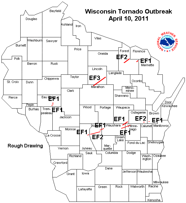
A strong, early spring storm moved across the region on the 9th and 10th of April 2011. On Saturday (April 9th), a warm front was the focus for severe thunderstorm development, and resulted in several tornadoes over northwest Iowa along with large hail and damaging winds. On Sunday, April 10th, the warm front pushed north across northern Wisconsin. The severe weather focus shifted to a low pressure area and associated cold front that would eventually push through the region. The atmosphere was unstable ahead of the front with favorable winds for storm organization, which included Supercells capable of tornadoes. Storms started to rapidly develop around 3 p.m. with many producing severe weather within 20 to 30 minutes of initiation. The storm movement was very fast - nearly 70 mph at times. The severe thunderstorms produced very large hail, damaging winds, and a few tornadoes. Storm surveys confirmed two tornadoes in central Wisconsin (Adams / Waushara Counties) and wind damage in parts of Houston County, MN (near Caledonia) and around Osseo, WI. Hail up to 3 inches in diameter pelted the southern sections of La Crosse as well as neighboring areas in Minnesota. Car, roof, and siding damage was common. Golf ball sized hail fell at the NWS La Crosse office for a brief period. There were 15 tornadoes in Wisconsin on Sunday, April 10th, which set a new record for the most ever for an April day in Wisconsin. The previous record was set on April 27, 1984, when 10 tornadoes occurred, with 3 fatalities and 42 injuries. That day in 1984 had two F4 intensity tornadoes which have winds of 207-260 mph. On Sunday, the strongest tornado surveyed was EF3 intensity (which has winds around 150 mph). For more information on the Wisconsin tornadoes, see the NWS Milwaukee summary, or the write up from . |
 Radar loop showing animation of rotation between 6:10-6:35 p.m. |
Tornadoes:
|
Tornado - Necedah, WI
Track Map   |
||||||||||||||||
|
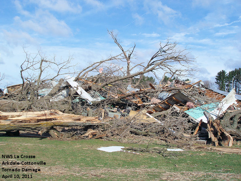
Tornado - Arkdale / Cottonville, WI
Track Map  |
||||||||||||||||
|
Tornado - 5 miles SW Hancock, WI
Track Map |
||||||||||||||||
The Enhanced Fujita (EF) Scale classifies tornadoes into the following categories:
| EF0 Weak 65-85 mph |
EF1 Moderate 86-110 mph |
EF2 Significant 111-135 mph |
EF3 Severe 136-165 mph |
EF4 Extreme 166-200 mph |
EF5 Catastrophic 200+ mph |
 |
|||||
Photos:
Arkdale - Cottonville Tornado
 |
 |
 |
 |
 |
 |
 |
 |
 |
 |
 |
 |
 |
 |
 |
 |
 |
 |
 |
 |
 |
 |
 |
 |
 |
Damage from Necedah, WI area tornado
 |
 |
 |
 |
La Crosse, WI area large hail
 |
 |
 |
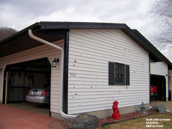 |
| Large hail near La Crosse, WI | Large hail near La Crosse, WI (Photo by John Wetenkamp) |
Siding damage on the south side of La Crosse, WI | Siding damage on the south side of La Crosse, WI |
 |
|||
| Hail embedded in the ground, south side of La Crosse |
Radar:
 |
 |
 |
 |
| Radar depiction of the rotation near Cottonville, WI | Radar animation from approx. 3:30 p.m. to 8 p.m. (every 10 min) | Radar animation from approx. 3:30 p.m. to 10 p.m. | Reflectivity image as storms approached La Crosse, WI (4:37 p.m.) |
 |
 |
 |
|
| Reflectivity animation of large hail producer that moved across southern La Crosse. | Reflectivity image as storms moved across Juneau and Adams Counties (6:18 p.m.) | Storm relative motion image depicting circulation in storm near Cottonville, WI (7:04 p.m.) |
Storm Reports
PRELIMINARY LOCAL STORM REPORT...SUMMARY
NATIONAL WEATHER SERVICE LA CROSSE WI
400 PM CDT MON APR 11 2011

..TIME...   ...EVENT...      ...CITY LOCATION...     ...LAT.LON...
..DATE...   ....MAG....      ..COUNTY LOCATION..ST.. ...SOURCE....
            ..REMARKS..

0423 AM     HAIL             NEW HAMPTON             43.06N 92.31W
04/10/2011  M0.50 INCH       CHICKASAW          IA   LAW ENFORCEMENT

0340 PM     HAIL             ELMA                    43.25N 92.44W
04/10/2011  M0.75 INCH       HOWARD             IA   EMERGENCY MNGR

            40-50 MPH ESTIMATED WIND ALSO

0350 PM     HAIL             NELSON                  44.42N 92.00W
04/10/2011  M1.00 INCH       BUFFALO            WI   TRAINED SPOTTER

0400 PM     HAIL             7 W HARMONY             43.56N 92.15W
04/10/2011  M0.75 INCH       FILLMORE           MN   EMERGENCY MNGR

            ALSO REPORTED 40 MPH WINDS

0403 PM     HAIL             4 N HARMONY             43.61N 92.01W
04/10/2011  E0.50 INCH       FILLMORE           MN   LAW ENFORCEMENT

0411 PM     TSTM WND DMG     2 N BURR OAK            43.48N 91.88W
04/10/2011                   WINNESHIEK         IA   LAW ENFORCEMENT

            SOME TREES AND POWER LINES DOWN AND BUILDING DAMAGE

0415 PM     TSTM WND DMG     4 E CANTON              43.53N 91.85W
04/10/2011                   FILLMORE           MN   LAW ENFORCEMENT

            BARN DOWN AND 1 TREE DOWN ON ROAD

0420 PM     TSTM WND DMG     2 SW CANTON             43.51N 91.96W
04/10/2011                   FILLMORE           MN   TRAINED SPOTTER

            2 FOOT DIAMETER TREE DOWN BLOCKING THE ROAD.

0424 PM     HAIL             NELSON                  44.42N 92.00W
04/10/2011  E0.88 INCH       BUFFALO            WI   FIRE DEPT/RESCUE

            ALSO SEEING OCCASIONAL WALL CLOUD WITH SOME SLIGHT
            LOWERING. NO ROTATION AT THIS TIME.

0427 PM     HAIL             HOUSTON                 43.76N 91.57W
04/10/2011  M1.75 INCH       HOUSTON            MN   EMERGENCY MNGR

0430 PM     TSTM WND DMG     5 N CALEDONIA           43.71N 91.50W
04/10/2011                   HOUSTON            MN   EMERGENCY MNGR

            MOBILE HOME KNOCKED OFF FOUNDATION

0432 PM     HAIL             GOODVIEW                44.07N 91.71W
04/10/2011  E1.00 INCH       WINONA             MN   TRAINED SPOTTER

0432 PM     TSTM WND DMG     CALEDONIA               43.63N 91.50W
04/10/2011                   HOUSTON            MN   EMERGENCY MNGR

            BARN DOWN JUST OUTSIDE CALEDONIA

0434 PM     HAIL             1 N MONDOVI             44.58N 91.67W
04/10/2011  E1.00 INCH       BUFFALO            WI   PUBLIC

            MULTIPLE REPORTS OF HAIL AROUND QUARTER SIZE

0434 PM     TSTM WND DMG     8 N CALEDONIA           43.75N 91.50W
04/10/2011                   HOUSTON            MN   EMERGENCY MNGR

            NUMEROUS TREES AND POWER LINES DOWN ALONG HWY 76

0435 PM     HAIL             5 E FOUNTAIN CITY       44.12N 91.60W
04/10/2011  E1.25 INCH       BUFFALO            WI   TRAINED SPOTTER

0437 PM     HAIL             ARCADIA                 44.25N 91.49W
04/10/2011  E0.75 INCH       TREMPEALEAU        WI   LAW ENFORCEMENT

0438 PM     TSTM WND DMG     BLACK HAMMER            43.61N 91.67W
04/10/2011                   HOUSTON            MN   LAW ENFORCEMENT

            SEVERAL TREES DOWN ALONG COUNTY ROAD 19. POSSIBLE TORNADO
            TOUCHDOWN. DEPUTY ON THE WAY TO INVESTIGATE.

0442 PM     HAIL             2 E HOKAH               43.76N 91.31W
04/10/2011  M2.75 INCH       HOUSTON            MN   EMERGENCY MNGR

0442 PM     HAIL             HOKAH                   43.76N 91.35W
04/10/2011  E3.00 INCH       HOUSTON            MN   TRAINED SPOTTER

            HAIL COVERING THE GROUND WITH SOME TREES DOWN.

0442 PM     HAIL             ARCADIA                 44.25N 91.49W
04/10/2011  E1.25 INCH       TREMPEALEAU        WI   TRAINED SPOTTER

0444 PM     HAIL             1 S HOKAH               43.75N 91.35W
04/10/2011  M1.00 INCH       HOUSTON            MN   CO-OP OBSERVER

            ALSO 0.50 INCHES OF RAIN IN LESS THAN 5 MINUTES AND VERY
            STRONG WINDS. POWER WENT OUT.

0445 PM     HAIL             3 NW BROWNSVILLE        43.73N 91.32W
04/10/2011  E1.75 INCH       HOUSTON            MN   TRAINED SPOTTER

0445 PM     TSTM WND DMG     5 N CALEDONIA           43.71N 91.50W
04/10/2011                   HOUSTON            MN   LAW ENFORCEMENT

            BARN DOWN AND TRAILER BLOWN OFF ITS FOUNDATION.

0451 PM     TSTM WND GST     2 S LA CROSSE           43.80N 91.23W
04/10/2011  E60.00 MPH       LA CROSSE          WI   AMATEUR RADIO

0451 PM     HAIL             2 S LA CROSSE           43.80N 91.23W
04/10/2011  E1.50 INCH       LA CROSSE          WI   AMATEUR RADIO

            HALF DOLLAR SIZE HAIL

0452 PM     HAIL             2 S LA CROSSE           43.80N 91.23W
04/10/2011  E1.00 INCH       LA CROSSE          WI   LAW ENFORCEMENT

            ON WARD AVENUE IN SOUTH LA CROSSE

0453 PM     HAIL             2 S LA CROSSE           43.80N 91.23W
04/10/2011  E2.00 INCH       LA CROSSE          WI   PUBLIC

            EXTENSIVE HAIL DAMAGE ON THE SOUTH SIDE OF LA CROSSE NEAR
            WAL MART. WINDOWS BROKEN AND SIDING DAMAGED TO AN
            ESTIMATED 10 TO 15 HOMES. SEVERAL VEHICLES ALSO DAMAGED
            WITH DENTS AND BROKEN WINDOWS AND MIRRORS.

0453 PM     HAIL             3 SE LA CROSSE          43.80N 91.19W
04/10/2011  E2.50 INCH       LA CROSSE          WI   AMATEUR RADIO

            AT SOUTHERN BLUFFS SCHOOL

0454 PM     HAIL             2 S LA CROSSE           43.80N 91.23W
04/10/2011  E2.00 INCH       LA CROSSE          WI   AMATEUR RADIO

            SOUTH SIDE

0454 PM     HAIL             3 E LA CROSSE           43.83N 91.17W
04/10/2011  E1.75 INCH       LA CROSSE          WI   NWS EMPLOYEE

            AT NWS OFFICE

0454 PM     HAIL             5 S OSSEO               44.51N 91.22W
04/10/2011  E1.75 INCH       TREMPEALEAU        WI   TRAINED SPOTTER

0455 PM     HAIL             3 E LA CROSSE           43.83N 91.17W
04/10/2011  M1.75 INCH       LA CROSSE          WI   LAW ENFORCEMENT

            AT HWY 14 AND CTH MM

0456 PM     TSTM WND GST     1 E LA CROSSE           43.83N 91.21W
04/10/2011  M52.00 MPH       LA CROSSE          WI   NWS EMPLOYEE

            AT NWS OFFICE

0459 PM     HAIL             WEST SALEM              43.90N 91.08W
04/10/2011  M1.00 INCH       LA CROSSE          WI   NWS EMPLOYEE

            ALSO 40 MPH WIND

0500 PM     TSTM WND DMG     OSSEO                   44.58N 91.22W
04/10/2011                   TREMPEALEAU        WI   TRAINED SPOTTER

            LOTS OF WINDOWS BROKEN AND CARS DENTED FROM WHAT APPEARS
            TO BE WIND BLOWN DEBRIS.

0510 PM     TSTM WND DMG     1 N GENOA               43.59N 91.23W
04/10/2011                   VERNON             WI   LAW ENFORCEMENT

            POWERLINES DOWN ON MOUND RIDGE RD

0516 PM     HAIL             1 S SPARTA              43.93N 90.81W
04/10/2011  M1.00 INCH       MONROE             WI   LAW ENFORCEMENT

            AT I-90 EXIT 25

0525 PM     HAIL             7 E SPARTA              43.94N 90.67W
04/10/2011  M1.75 INCH       MONROE             WI   LAW ENFORCEMENT

            AT HWY 16 AND CTH A

0530 PM     HAIL             1 N TOMAH               44.00N 90.50W
04/10/2011  M1.25 INCH       MONROE             WI   TRAINED SPOTTER

0530 PM     HAIL             MEDFORD                 45.14N 90.35W
04/10/2011  E1.00 INCH       TAYLOR             WI   PUBLIC

0532 PM     HAIL             TUNNEL CITY             44.00N 90.57W
04/10/2011  M0.50 INCH       MONROE             WI   TRAINED SPOTTER

0536 PM     FUNNEL CLOUD     3 SW OAKDALE            43.93N 90.42W
04/10/2011                   MONROE             WI   LAW ENFORCEMENT

            POSSIBLE FUNNEL REPORTED BY PUBLIC

0538 PM     HAIL             2 W TOMAH               43.99N 90.54W
04/10/2011  M0.75 INCH       MONROE             WI   TRAINED SPOTTER

0538 PM     HAIL             WARRENS                 44.13N 90.50W
04/10/2011  E1.00 INCH       MONROE             WI   AMATEUR RADIO

0539 PM     HAIL             3 W WITHEE              44.95N 90.66W
04/10/2011  M0.25 INCH       CLARK              WI   LAW ENFORCEMENT

0540 PM     HAIL             TOMAH                   43.99N 90.50W
04/10/2011  E2.50 INCH       MONROE             WI   STORM CHASER

            HAIL MEASUREMENTS BETWEEN GOLF BALL AND TENNIS BALL SIZE.
            WIND GUSTS ALSO ESTIMATED AROUND 70 MPH.

0542 PM     HAIL             4 SW STETSONVILLE       45.04N 90.37W
04/10/2011  E1.00 INCH       TAYLOR             WI   LAW ENFORCEMENT

0608 PM     TSTM WND DMG     3 SE NECEDAH            43.99N 90.03W
04/10/2011                   JUNEAU             WI   LAW ENFORCEMENT

            8 TO 10 INCH PINE TREES UPROOTED AND A GARAGE DOWN. WINDS
            ESTIMATED 60 MPH.

0610 PM     TSTM WND GST     VOLK FIELD              43.93N 90.27W
04/10/2011  M56.00 MPH       JUNEAU             WI   ASOS

0610 PM     TSTM WND DMG     NECEDAH                 44.02N 90.07W
04/10/2011                   JUNEAU             WI   LAW ENFORCEMENT

            FUNNEL CLOUD WITH TREES DOWN.

0610 PM     TORNADO          1 NW ARKDALE            44.04N 89.90W
04/10/2011                   ADAMS              WI   PUBLIC

            POSSIBLE TORNADO REPORTED BY PUBLIC. CONSIDERABLE TREE
            DAMAGE.

0612 PM     TORNADO          1 W ARKDALE             44.03N 89.90W
04/10/2011  F2               ADAMS              WI   LAW ENFORCEMENT

            EF2. 17 MILE LENGTH. 1/2 MILE MAX WIDTH. FROM JUST WEST
            OF ARKDALE TO COTTONWOOD TO COUNTY RD G.

0618 PM     HAIL             1 E NECEDAH             44.02N 90.05W
04/10/2011  M1.25 INCH       JUNEAU             WI   AMATEUR RADIO

0618 PM     HAIL             5 ENE MEDFORD           45.17N 90.25W
04/10/2011  E1.75 INCH       TAYLOR             WI   LAW ENFORCEMENT

0618 PM     HAIL             3 SE NECEDAH            43.99N 90.03W
04/10/2011  M1.25 INCH       JUNEAU             WI   AMATEUR RADIO

0623 PM     HAIL             BIG FLATS               44.12N 89.80W
04/10/2011  E1.00 INCH       ADAMS              WI   TRAINED SPOTTER

0625 PM     TSTM WND DMG     COTTONVILLE             44.06N 89.81W
04/10/2011                   ADAMS              WI   TRAINED SPOTTER

            TREES DOWN.

0630 PM     HAIL             NEW ROME                44.24N 89.88W
04/10/2011  E0.75 INCH       ADAMS              WI   TRAINED SPOTTER

0630 PM     TORNADO          COTTONVILLE             44.06N 89.81W
04/10/2011                   ADAMS              WI   AMATEUR RADIO

            REPORTED BY SPOTTER

0630 PM     TORNADO          7 E COTTONVILLE         44.06N 89.67W
04/10/2011  F1               ADAMS              WI   LAW ENFORCEMENT

            EF1

0725 PM     HAIL             2 S FRIENDSHIP          43.95N 89.82W
04/10/2011  M0.88 INCH       ADAMS              WI   TRAINED SPOTTER

            DIME HAIL IN ADAMS

0727 PM     HAIL             ADAMS                   43.96N 89.82W
04/10/2011  E0.75 INCH       ADAMS              WI   TRAINED SPOTTER
2-Day Rain Reports (April 9-10)
PUBLIC INFORMATION STATEMENT
NATIONAL WEATHER SERVICE LA CROSSE WI
1122 AM CDT MON APR 11 2011

...RAINFALL TOTALS FOR APRIL 9TH-10TH...

LOCATION                     COUNTY        RAINFALL


NORTHEAST IOWA

ST. ANSGAR                   MITCHELL       0.97
OSAGE                        MITCHELL       0.81
CRESCO 1NE                   HOWARD         0.69
DECORAH AWOS                 WINNESHIEK     0.26
NEW HAMPTON                  CHICKASAW      0.21
CHARLES CITY                 FLOYD          0.20
WAUKON                       ALLAMAKEE      0.20
LANSING 4SE                  ALLAMAKEE      0.11
IONIA                        CHICKASAW      0.10
VOLGA                        FAYETTE        0.03
ELKADER 6SSW                 FAYETTE        0.01


SOUTHEAST MINNESOTA

GRAND MEADOW                 MOWER          2.44
LA CRESCENT 1N               HOUSTON        1.73
SPRING VALLEY                FILLMORE       1.72
LA CRESCENT                  HOUSTON        1.71
AUSTIN AWOS                  MOWER          1.66
SPRING VALLEY 3E             FILLMORE       1.62
WINONA AWOS                  WINONA         1.61
WINONA LOCK AND DAM 5A       WINONA         1.61
LANESBORO                    FILLMORE       1.33
ROCHESTER 2NE                OLMSTED        1.32
ROCHESTER ASOS               OLMSTED        1.22
PRESTON                      FILLMORE       1.20
PRESTON AWOS                 FILLMORE       1.14
MINNESOTA CITY               WINONA         1.13
SPRING GROVE                 HOUSTON        1.09
WABASHA                      WABASHA        1.08
THEILMAN                     WABASHA        1.04
HIGHLAND                     FILLMORE       0.95
ELGIN 2SSW                   WABASHA        0.77
BYRON                        OLMSTED        0.75
DODGE CENTER AWOS            DODGE          0.63
LAKE CITY                    WABASHA        0.51
CALEDONIA                    HOUSTON        0.31


SOUTHWEST WISCONSIN

FRENCH ISLAND                LA CROSSE      2.10
LA CROSSE ASOS               LA CROSSE      1.92
WARRENS 5WSW                 MONROE         1.89
GALESVILLE 2ESE              TREMPEALEAU    1.76
SPARTA                       MONROE         1.73
TUNNEL CITY 1S               MONROE         1.65
FOUR CORNERS                 MONROE         1.62
BLAIR 2NW                    TREMPEALEAU    1.58
NEILLSVILLE 3SW              CLARK          1.55
TREMPEALEAU                  TREMPEALEAU    1.49
WEST SALEM                   LA CROSSE      1.43
BLACK RIVER FALLS            JACKSON        1.38
ALMA                         BUFFALO        1.23
SPARTA - FT MCCOY AWOS       MONROE         1.22
MEDFORD                      TAYLOR         1.07
LA CROSSE WFO                LA CROSSE      0.98
GAD                          TAYLOR         0.83
ROCK DAM                     CLARK          0.70
OWEN 2N                      CLARK          0.60
OSSEO                        TREMPEALEAU    0.60
NEW LISBON 4ENE              JUNEAU         0.36
FRIENDSHIP                   ADAMS          0.35
WESTBY 3ENE                  VERNON         0.28
RICHLAND CENTER              RICHLAND       0.26
GENOA                        VERNON         0.17
RICHLAND CENTER 4N           RICHLAND       0.17
GAYS MILLS                   CRAWFORD       0.13
VIROQUA                      VERNON         0.12
ONTARIO                      VERNON         0.12
STEUBEN 4SE                  CRAWFORD       0.10
SOLDIERS GROVE               CRAWFORD       0.09
LA FARGE                     VERNON         0.09
HILLSBORO                    VERNON         0.06
LYNXVILLE                    CRAWFORD       0.06
PRAIRIE DU CHIEN AWOS        CRAWFORD       0.05
BOSCOBEL AWOS                GRANT          0.05
PRAIRIE DU CHIEN             CRAWFORD       0.04
PLATTEVILLE                  GRANT          0.02


OBSERVATIONS ARE COLLECTED FROM A VARIETY OF SOURCES WITH VARYING
EQUIPMENT AND EXPOSURE. NOT ALL DATA LISTED IS CONSIDERED OFFICIAL.

FOR THIS...AND A WEALTH OF OTHER RIVER AND WEATHER INFORMATION...
VISIT OUR WEBSITE AT  WEATHER.GOV/LACROSSE
 |
Media use of NWS Web News Stories is encouraged! Please acknowledge the NWS as the source of any news information accessed from this site. |
|


 Follow us on YouTube