The remnants of Tropical Storm Hermine brought copious amounts of rain to Eastern Oklahoma and Northwest Arkansas on September 8th and 9th 2010 as it moved out of Texas and across Oklahoma. Much of Eastern Oklahoma and Northwest Arkansas recieved 1 to 4 inches of rain. However...there was a swath of 8 to 14 inch rainfall totals across East-Central Oklahoma and West-Central Arkansas. These heavy rains led to numerous reports of flooding especially in the area of heaviest rain.
|
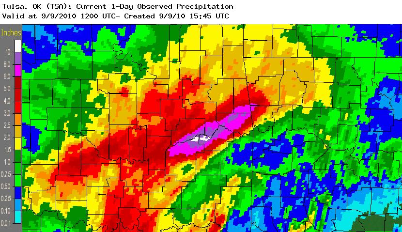
1 Day Rainfall Total For Tulsa CWA Ending at 7 am Sep 9 |
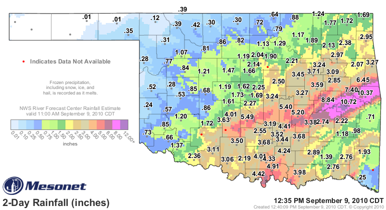
2 Day Rainfall Totals for OK Ending at 1235 pm Sep 9 |
|
|
 |
| 1 Day Rainfall Total For Tulsa CWA Ending at 7 am Sep 10 | 3 Day Rainfall Totals from 6 am 9/7/10 to 6 am 9/10/10 |
 |
 |
| Measured Rainfall Totals 3-Day Storm Total Amounts in Inches |
||||
| Location | Amount | Source | ||
| Whitefield | 13.42 | Automated Gage | ||
| Stigler | 11.25 | OK Mesonet | ||
| Sallisaw | 10.41 | OK Mesonet | ||
| Eufaula (4.6ENE) | 10.35 | CoCoRaHS | ||
| Mountainburg (2NE) | 9.81 | NWS Coop | ||
| R.S. Kerr Reservoir | 9.60 | Automated Gage | ||
| Natural Dam | 9.00 | NWS Coop | ||
| Short (1W) | 8.40 | Automated Gage | ||
| Scipio (1S) | 7.69 | NWS Coop | ||
| Webbers Falls | 7.40 | OK Mesonet | ||
| Bunch (0.8N) | 6.95 | CoCoRaHS | ||
| St. Paul (1E) | 6.92 | NWS Coop | ||
| Cookson | 6.20 | OK Mesonet | ||
| Webbers Falls L&D | 6.13 | Automated Gage | ||
| Tenkiller Lake | 6.11 | Automated Gage | ||
| Big Cedar | 5.90 | Automated Gage | ||
| Gore | 5.63 | Automated Gage | ||
| Stigler | 5.63 | Automated Gage | ||
| Van Buren | 5.36 | Automated Gage | ||
| Eufaula Lake | 5.28 | Automated Gage | ||
| Rudy | 5.21 | Automated Gage | ||
| Devils Den St. Park | 4.78 | NWS Coop | ||
| Arthur City | 4.36 | Automated Gage | ||
| Springdale (5.8 ENE) | 4.30 | CoCoRaHS | ||
| Eureka Springs (0.5N) | 4.25 | CoCoRaHS | ||
| Alma (1.5NNW) | 4.12 | CoCoRaHS | ||
| Busch (0.4E) | 4.08 | CoCoRaHS | ||
| Garfield (3.9E) | 3.89 (24 hour total) | CoCoRaHS | ||
| Cloudy | 3.82 | Automated Gage | ||
| Tulsa (6 SSW) | 3.80 | CoCoRaHS | ||
| Bixby | 3.71 | OK Mesonet | ||
| Okmulgee | 3.59 | OK Mesonet | ||
| Muskogee | 3.54 | ASOS | ||
| Bristow | 3.45 | OK Mesonet | ||
| Stuart | 3.36 | OK Mesonet | ||
| Jenks (4.5 ENE) | 3.36 | CoCoRaHS | ||
| Okemah | 3.27 | OK Mesonet | ||
| Westville | 3.24 | OK Mesonet | ||
| Newt Graham L&D | 3.20 | Automated Gage | ||
| W.D. Mayo L&D | 3.15 | Automated Gage | ||
| Fayetteville (4E) | 3.00 | Automated Gage | ||
| Fayetteville | 3.00 | ASOS | ||
| Fayetteville (1E) | 2.98 | CoCoRaHS | ||
| Fort Smith (1.6 NNW) | 2.96 | CoCoRaHS | ||
| Berryville | 2.96 | Automated Gage | ||
| Heyburn Lake | 2.96 | Automated Gage | ||
| Bentonville (0.6W) | 2.95 | CoCoRaHS | ||
| Hugo Lake | 2.85 | Automated Gage | ||
| Hartshorne (4ESE) | 2.80 | Automated Gage | ||
| Pryor | 2.73 | Automated Gage | ||
| Kansas | 2.68 | Automated Gage | ||
| McAlester | 2.67 | ASOS | ||
| Chouteau L&D | 2.53 | Automated Gage | ||
| Pea Ridge (0.2 WSW) | 2.52 | CoCoRaHS | ||
| Antlers | 2.51 | OK Mesonet | ||
| Siloam Springs (4SE) | 2.51 | Automated Gage | ||
| OK Mesonet - Courtesy of the Oklahoma Climatological Survey | ||||
| CoCoRaHS - Volunteer Observers (ending 8 am CDT 9/10/2010) | ||||
| Coop - NWS Observers (ending 7am CDT 9/10/2010) | ||||
| ASOS - Automated Surface Observing System | ||||
| Automated Gage (ending 1030am CDT 9/10/2010) | ||||
|
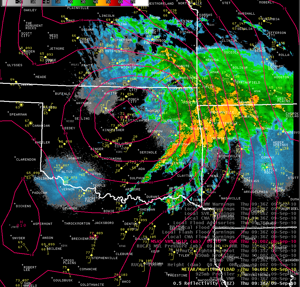
Track of Hermine Through Oklahoma |
|
9 pm CDT Sep. 8 2010 |
1 am CDT Sep. 9 2010 |
|
5am CDT Sep. 9 2010 |
9 am CDT Sep. 9 2010 |
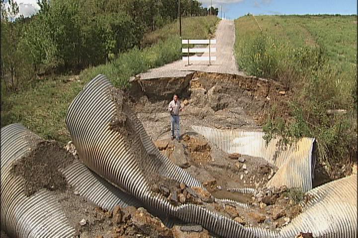
Flooding Images
In additional to being swept away while driving over flooded roads, drivers do not know the condition of the road under the high water, as seen in several images below.
 |
 |
 |
| Pittsburg Co. road washed out from flash flooding. Image courtesy of KOTV. Go to the KOTV.com video (you will be leaving the NWS website). | Flooding in Sequoyah County. Image courtesy of Sequoyah County Times | Car stranded in flooded underpass in Sequoyah County. Image courtesy of Sequoyah County Times |
 |
 |
 |
| Debris left on road after flash flooding. Image courtesy of Sequoyah County Times | Barbed wire and large tree debris after flash flooding at a low water crossing in Muskogee County. Image courtesy of Ed Calianese, NWS | Road closed due to high water in Sequoyah County. Image courtesy of Sequoyah County Times |