| La Niña Conditions Expected for the Upcoming Winter | ||
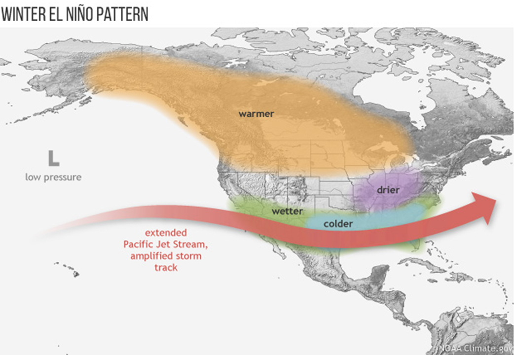
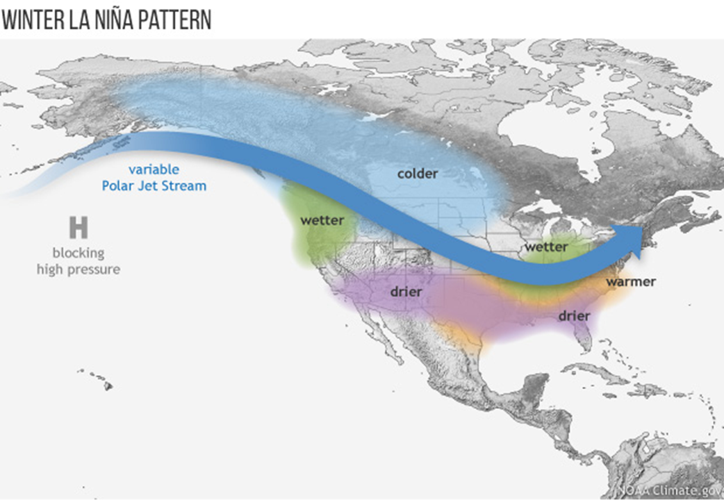
The outlook from the Climate Prediction Center for the upcoming winter of 2021-22 is saying that La Niña conditions are expected to persist and likely continue into next spring. During the winter, La Niña typically brings above-average precipitation and colder-than-average temperatures along the northern tier of the U.S., along with below-average precipitation and above-average temperatures across the South. However, other climate patterns, such as the Madden-Julian Oscillation and Arctic Oscillation (AO), can also play a role in determining winter weather. For example, the AO influences the number of arctic air masses that intrude into the U.S., but its predictability is limited to a couple of weeks. |
||
| Most images on this page can be magnified by clicking, and resized back to original size with a second click. |
||
 |
 |
|
CPC Outlook for Winter 2021-22: |
||
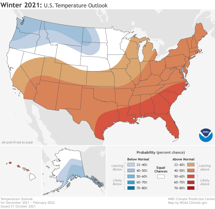
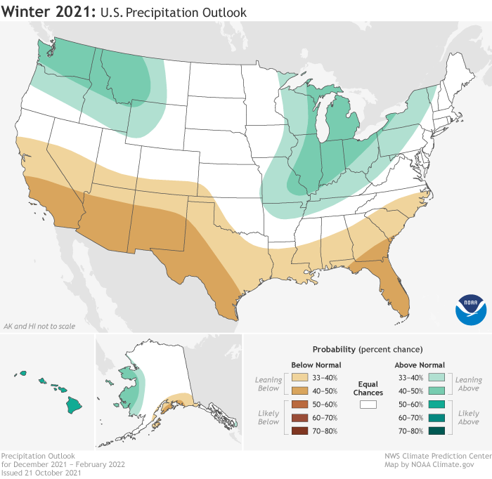
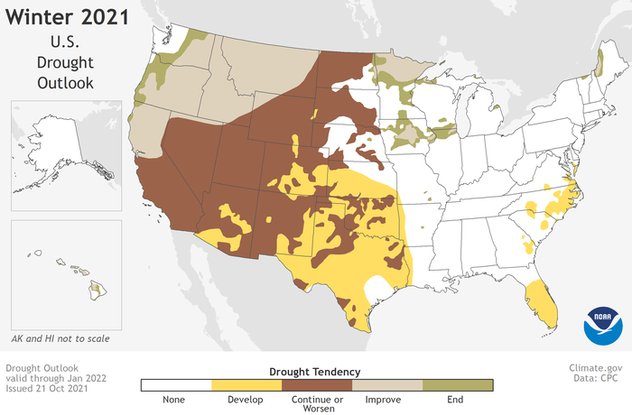
The overall forecast for West Central and Southwest Florida for the upcoming winter is for a better chance of above normal temperatures and below normal rainfall as can be seen in the Climate Prediction Center Winter Outlook graphics below. This fits the long term trend across our area during a La Niña phase of slightly above normal temperatures during the Winter with rainfall during these months usually below normal. There will likely be a few freezes across the region, especially the Nature Coast, but prolonged cold weather is not anticipated at this time. Drought conditions may also develop during this time and especially next spring as numerous fair and warm days are anticipated. |
||
   |
||
ENSO State: |
||
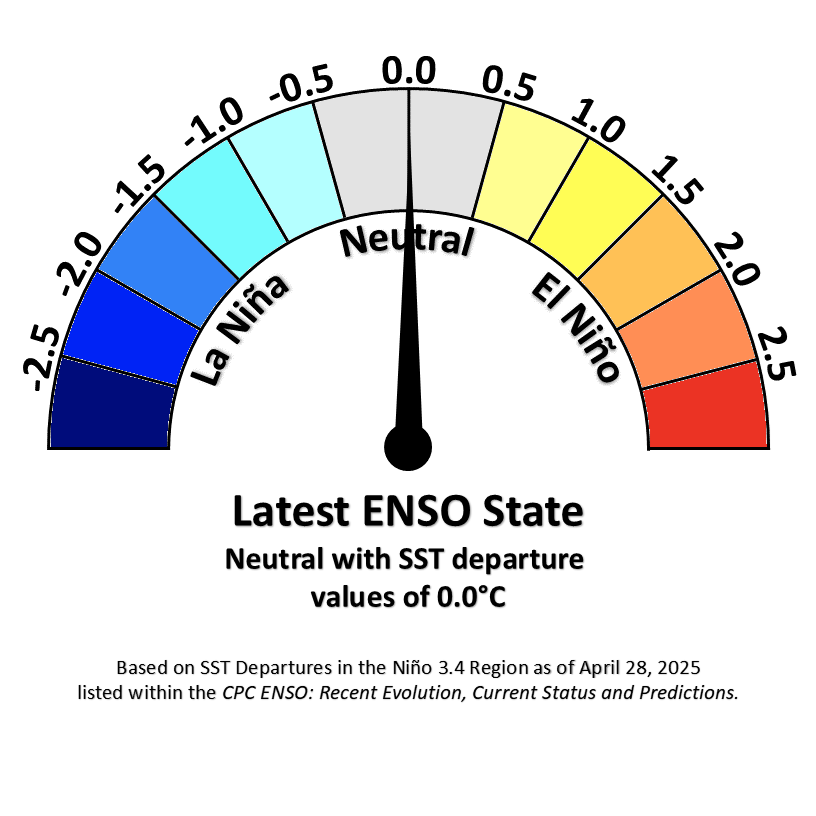 ENSO Phase Meter |
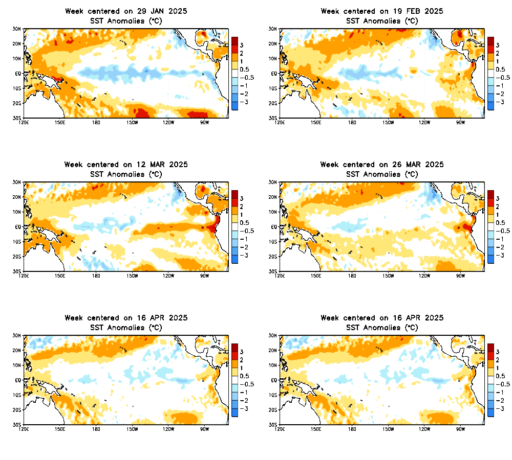 Tropical Pacific SST Anomalies |
|
CPC ENSO: Recent Evolution, Current Status and Predictions |
||
ENSO History: |
|||||||||
We had La Niña conditions last winter with temperatures generally averaging near to slightly above normal while rainfall ranged from well below normal to near normal. Before this, ENSO Neutral conditions occurred during the winter of 2019-2020 with above normal temperatures, while rainfall ranged from well below normal to slightly above normal. In the previous winter of 2018-19 there were weak El Niño conditions with above normal rainfall, but temperatures actually averaged out a couple of degrees above average thanks to a very warm February. This winter into next spring La Niña conditions are forecast so we are anticipating that rainfall will be below normal while temperatures should average out slightly above normal overall, but could vary greatly from week to week. Following are U.S. maps of the Winter (December-February) departure from average precipitation and temperature for each category of El Niño and La Niña since 1950. |
|||||||||
|
|||||||||
ENSO Local Rainfall: |
|||||||||||||||||||||||||||||||||||||||||||||||||||||||||||||||||||||||||||||||||
During El Niño there tends to be more stormy conditions across the Florida peninsula during the winter and early spring. Cold fronts will move across the region and with the jet stream further south and stronger, rainfall is more widespread and therefore usually above average. This can be seen in the graphics below where rainfall totals during the dry season average much higher during El Niño winters then during La Niña winters. |
|||||||||||||||||||||||||||||||||||||||||||||||||||||||||||||||||||||||||||||||||
|
|||||||||||||||||||||||||||||||||||||||||||||||||||||||||||||||||||||||||||||||||
Another way to see this is by viewing the Box and Whisker Distribution Plots* for the three climate zones across the Florida peninsula shown below: |
|||||||||||||||||||||||||||||||||||||||||||||||||||||||||||||||||||||||||||||||||
|
|||||||||||||||||||||||||||||||||||||||||||||||||||||||||||||||||||||||||||||||||
ENSO Local Temperature: |
|||||||||||||||||||||||||||||||||||||||||||||||||||||||||||||||||||||||||||||||||
The link between ENSO and wintertime temperatures is a little bit weaker. With the average storm track farther south during El Niño temperatures tend to average slightly below normal thanks to the increased clouds and rain that keep daytime highs cooler. This is in contrast to La Niña where we usually see drier air over the state with more fair weather days. This drier air leads to warmer daytime and slightly cooler nighttime temperatures that overall result in slightly above average temperatures across the area. What plays a larger role in controlling temperatures across Florida during the winter and early spring is the Arctic Oscillation (AO) as we saw back in early 2010. This oscillation shifts on a monthly and sometimes weekly basis and typically is not included in long term forecasts. For more details about the AO and its effect on West Central and Southwest Florida visit Arctic Oscillation: Impacts on West Central and Southwest Florida. |
|||||||||||||||||||||||||||||||||||||||||||||||||||||||||||||||||||||||||||||||||
|
|||||||||||||||||||||||||||||||||||||||||||||||||||||||||||||||||||||||||||||||||
This can also be seen in the Box and Whisker Distribution Plots* for the three climate zones across the Florida peninsula shown below: |
|||||||||||||||||||||||||||||||||||||||||||||||||||||||||||||||||||||||||||||||||
|
|||||||||||||||||||||||||||||||||||||||||||||||||||||||||||||||||||||||||||||||||
ENSO Local Freezes: |
|||||||||||||||||||||||||||||||||||||||
Freezing temperatures are possible into Central and South Florida during any winter no matter what the ENSO phase is that year. During El Niño conditions the likely cause of freezing temperatures is advection of cold air dragged southward behind low pressure systems that pass across the state. This is unlike La Niña conditions where the main cause is radiational cooling under clear skies and calm winds. Long term averages indicate three to six days of freezing temperatures each winter across inland portions of Central Florida with only about one freeze over Southwest Florida. Farther north across the Nature Coast many more days of freezing temperatures occur with some locations such as Inverness and Bushnell having on average around 12 days, while farther north near Chiefland there are as many as 20 days with temperatures falling to or below 32° each winter. Overall the difference in the number of days with freezing temperatures each winter is not that much between the ENSO phases as seen in the graphics below, but more dependent on the phase of the Arctic Oscillation (AO). For more details visit Arctic Oscillation: Impacts on West Central and Southwest Florida. |
|||||||||||||||||||||||||||||||||||||||
|
|||||||||||||||||||||||||||||||||||||||