Public Information Statement
National Weather Service Charleston WV
414 PM EDT Thu Oct 3 2024
...A WARM SEPTEMBER FOR THE NWS CHARLESTON FORECAST AREA AMID A WIDE RANGE IN PRECIPITATION TOTALS...
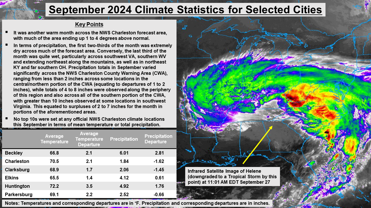
Compared to the 1991-2020 U.S. Climate Normals, it was a warm September across the vast majority of
the forecast area, with mean temperatures for much of the area ending up 1 to 4 degrees (Fahrenheit)
above normal, with a few locations trending closer to normal. In terms of precipitation, the first
two-thirds of the month was extremely dry across much of the forecast area, so much so that some
locations were on pace to potentially near the mark for their driest September on record. For
instance, Charleston, West Virginia had only received 0.09 inches of precipitation through the
22nd of September! This quickly changed, however, in the last third of the month given that it was
quite wet, particularly across southwest Virginia, southern West Virginia and extending northeast
along the mountains, as well as in northeast Kentucky and far southern Ohio. Multiple rounds of rain
would affect the NWS Charleston forecast area during this timeframe, with the most significant event
being associated with the remnants of Hurricane Helene and a corresponding Predecessor Rain Event (PRE)
in advance of the main circulation, with the greatest impacts occurring across the aforementioned areas.
Given such, total precipitation for the month of September varied significantly across the NWS
Charleston forecast area, ranging from less than 2 inches across some locations in the central/northern
portion of the County Warning Area (equating to departures of 1 to 2 inches), while totals of 4 to 8
inches were observed along the periphery of this region and also across all of the southern portion of
the County Warning Area, with greater than 10 inches observed at some locations in southwest Virginia.
This equated to surpluses of 2 to 7 inches for the month in the aforementioned areas. For the sake of
comparison, Charleston, West Virginia only received 1.84 inches of precipitation throughout September,
while one of our Cooperative Observer Program (COOP) locations in southwest Virginia (located just
southeast of Nora in Dickenson County) only about 100 miles to the southwest received 10.29 inches,
which is nearly 7 inches above what is normal there for September!
No top 10s were set at any of the official NWS Charleston climate locations this September in terms
of mean temperature or total precipitation.
$$