Summary of the March 2nd 2012 Tornadic Supercells
On Friday March 2nd, 2012, tornadic supercells that developed in central and eastern Kentucky tracked into West Virginia. These storms were responsible for two deaths, an undetermined amount of injuries, and large areas of destruction within the Charleston, WV (RLX) National Weather Service WFO county warning area.
On the morning of March 2nd, a deep upper- level trough over the central plains began lifting northeastward into the Ohio River Valley, with maximum jet speeds of 125mph. At the surface, low pressure centered near Missouri began to deepen and move northeastward toward the southern Great Lakes region. By early afternoon, a warm front was positioned from southern Illinois, across Kentucky, southeastward into the Tennessee River Valley. In response to strong southerly flow, dewpoints across much of Kentucky began to exceed 60F. Late in the afternoon, the cold front began moving across central Kentucky as the surface low began to occlude, and the warm front stalled over central West Virginia.
At 6pm, a number of supercells ahead of the cold front were moving across southeast Ohio, central Kentucky and eastern Kentucky. The strongest moved through West Liberty, KY, causing 8 deaths. This supercell entered the RLX county warning area (Lawrence County, KY) at approximately 6:10pm before dissipating over Lincoln County an hour later at approximately 7:10pm. It was responsible for 2 deaths in Lawrence County, Kentucky along with extensive damage in Dunlow and Kiahsville, West Virginia.
 |
|
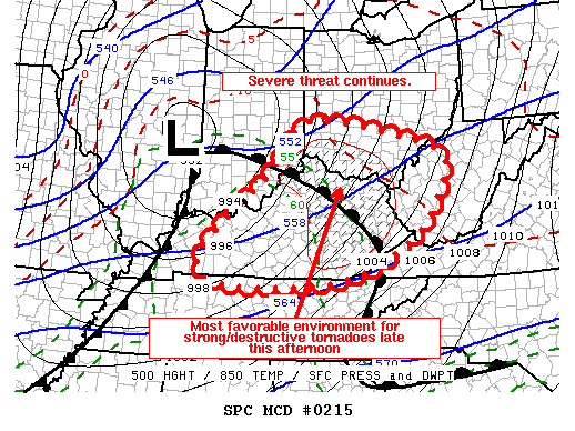
FIG. 1. SPC MCD #0215 At 215pm the Storm Prediction Center issued a Mesoscale Discussion outlining an area that was favorable for strong destructive tornadoes in the late afternoon.
|
 |
|
FIG. 2 Tornado Watch #62 At 420pm the SPC issued a Tornado Watch covering Eastern Kentucky, western West Virginia, and southeast Ohio. |
Storm 1 - Lawrence KY and Wayne County WV
 |
|
FIG. 3 This tornado path was almost 53mi long, and reached EF-3 strength. |
|
 |
|
FIG. 4 Basic Reflectivity of a classic hook echo as it crossed Wayne County. |
|
 |
|
FIG. 5 This is the Base Velocity at the same time and position. This helps us determine the magnitude of the circulation. |
|
Storm 2 - Lincoln County WV
 |
|
FIG. 6 This path was almost 16mi long. Rated an EF-1, it originated very close to where the long track tornado dissipated 30min earlier. |
|
 |
|
FIG. 7 Basic Reflectivity as the storm moved over Lincoln county |
|
 |
|
FIG. 8 Base Velocity at the same time and position showing the tight circulation. |
|
 |
|
FIG. 9 Storm2 moving in behind Storm1 |
|
Storm3 - Mingo County WV (Magoffin County KY, Johnson County KY, Martin County KY)
 |
|
FIG. 10 The storm wasn't in Mingo County long, but it did extensive damage to a 60 ft. communication tower. |
 |
|
FIG. 11 The entire track as it moved east toward Mingo County |
 |
|
FIG. 12 Base Reflectivity entering Mingo County |
 |
|
FIG. 13 B ase Reflectivity west of Mingo County with a distinct hook echo at 0024z |
 |
|
FIG 14. Base Velocity entering Mingo County |
 |
|
FIG. 15 Base Velocity west of Mingo county at 0024z |
Please contact us with any information you may have on the storms, especially pics! Also, don’t hesitate to ask us questions either by email or facebook.

