Supercell tracks across the
The second supercell in the past six weeks traveled across portions of southern
Severe thunderstorm watch number 823 was issued for the late afternoon and evening hours for portions of southern
As a line of storms crossed the
Supercells are very rare in the central Appalachians. Historically we experience about one per year. However, two have occurred within a six week time frame this convective season. Only about 20% of all supercells produce tornadoes, and it is still not clear to scientists why some supercells produce tornadoes and some do not. Lucky for us the storm on the evening of October 11th did not produce a tornado, nor did the one on August 30th.
The following images are surface analysis obtained from the Hydro-meteorological Prediction Center(HPC) from 21Z on the 11th and 00Z on the 12th. A strong cold front approached from the west, while the area was positioned in the warm sector, a favorable area for thunderstorm evolution. This is commonly the setup for severe weather in the middle Ohio Valley and Central Appalachians

Figure 1 21Z surface analysis from

Figure 2 00Z surface analysis from
The following images were taken from the
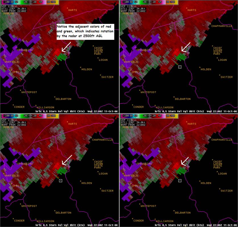
Figure 3 608 pm four panel storm relative velocity from KRLX WSR 88D.Notice the area of red and green colors adjacent to one another as highlighted by the arrow.

Figure 4 614pm 0.5 degree storm relative velocity. The radar continues to indicate low level rotation close to the ground.

Figure 5 0.5 degree storm relative velocity taken at 634pm.
No damage reports were relayed to the Charleston Weather Service Office. In fact, two employees surveyed portions of Logan and Mingo counties looking for any structural damage or signs of a possible tornado. Nothing was found the next day. One storm chaser was able to capture a picture of a possible funnel cloud along U.S. route 119 in Madison.
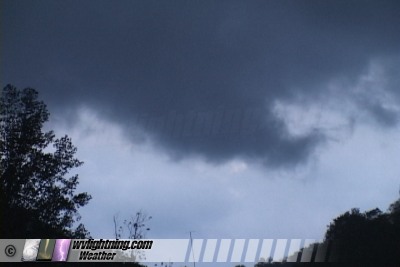
Figure 7: Photo courtesy of Dan Robinson of www.wvlightning.com of a possible funnel cloud south of
The illustration below shows warnings issued by the Charleston forecast office along with damage reports denoted by a 'W' for wind reports or 'H' for hail reports.

Figure 7 Local weather warnings issued the night of the October 11th (blue indicates severe thunderstorm warnings and red indicates tornado warnings). 'W's represent wind reports and 'H's denote hail reports relayed to the National Weather Service in Charleston, WV
|
TORNADO REPORTS |
||||||||||||||||||||||||||||||||||||||||||||||||
|
||||||||||||||||||||||||||||||||||||||||||||||||
|
FLASH FLOOD REPORTS |
||||||||||||||||||||||||||||||||||||||||||||||||
|
||||||||||||||||||||||||||||||||||||||||||||||||
|
|
||||||||||||||||||||||||||||||||||||||||||||||||
|
||||||||||||||||||||||||||||||||||||||||||||||||
|
HAIL REPORTS |
||||||||||||||||||||||||||||||||||||||||||||||||
|
||||||||||||||||||||||||||||||||||||||||||||||||
|
FUNNEL CLOUD REPORTS |
||||||||||||||||||||||||||||||||||||||||||||||||
|
Table 1. Tabular format of the severe weather reports received the night of October 11 2006.
REFERENCES
Brooks, H.E., C. A. Doswell
Doswell, C. A.,

