Severe Weather and Flash Flooding July 21st 2006
The Mid Ohio Valley and Central Appalachians were in the middle of another oppressive day in the lower 90s with dewpoints in the 70s on Friday July 21st. Charleston hit 90 degrees or above for the fourth consecutive day, while other locations like Parkersburg and Huntington due to cloud cover saw their streak come to a conclusion at three. Nonetheless, it was a true heat wave in these parts with three consecutive days at or above 90 degrees. Clouds across the Ohio River vicinity resulted from a stationary front that stretched from southern New England southeast through Missouri.
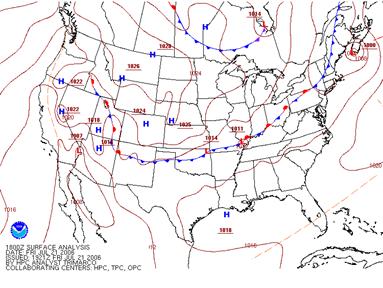
Figure 1 HPC's 18z July 21 2006 surface analysis
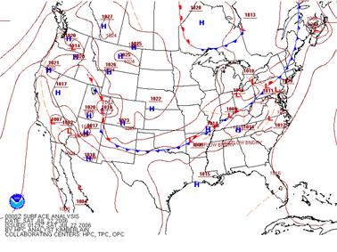
Figure 2: HPC's 00Z surface analysis July 22 2006
There was little difference on either side of the front with respect to the temperature and dewpoint fields. Temperatures were widespread in the upper 80s to near 90 with surface dewpoints in the upper 60s to lower 70s. A gigantic mesoscale convective system (MCS) developed across southern Illinois during the late morning hours then tracked southeast into western Kentucky during the early afternoon. Westerly winds aloft then steered the complex east across the Bluegrass state through the late afternoon and evening hours. With ample moisture and instability along with the stationary front as a trigger mechanism, thunderstorms developed in the heating of the day upstream of the MCS over eastern Kentucky, southern Ohio, and West Virginia. The atmosphere was very unstable with surface based capes of 3500 J/KG, Lifted Index of -6C, and Totals Index of 50. The Storm Prediction Center issued severe thunderstorm watch number 633 at 545pm for northeastern Kentucky for the evening hours of Friday July 21st with the approach of a large cluster of thunderstorms (see figure below for watch outline).
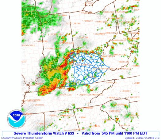
Figure 2: SPC's severe thunderstorm watch number 633 overlaid with radar mosaic.
Several severe thunderstorms warnings were issued by the National Weather Service in Charleston, however all warnings were for storms out ahead of the main cluster. The first warning was issued at 512pm for Barbour county with the last warning ending at 1045pm for Buchanan county Virginia. Storms pulsed up and down throughout the night prompting numerous special weather statements issued for non-severe storms. The strongest storm of the evening to affect Charleston' s forecast area was in Lawrence county Kentucky between 750pm and 830pm. It developed southeast of Lawrence county and moved northeast knocking down several trees and powerline in its path. In the community of Lowmansville, penny size hail was reported as the storm passed. Large trees and power lines fell in the tri state around Huntington as a thunderstorm passed between 615pm and 645pm.
As the complex grew closer during the mid evening hours storms re-developed over northeastern Kentucky and southern Ohio near the front. With the tropical state of the atmosphere, storms brought a lot of rainfall. Precipitable water is a way meteorologists capture how much moisture is in the air, and it was quite high Friday evening with values around 2.0 inches. Hourly rainfall rates in some of the downpours yielding two inches in one hour. The Grundy, VA IFLOWS gauge in southwestern Virginia reported 1.69 inches in 30 minutes! This prompted a flash flood warning to be issued for Buchanan county. After the storm and rain ended, three to four feet of water were in some homes along route 460 outside Grundy. Training thunderstorms over northeastern Kentucky also prompted a flash flood warning for Boyd county. Storm total precipitation derived from the KRLX is pictured below. Areas of yellow and red illustrate two to three inches of rainfall for the event.
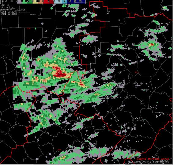
Figure 3: KRLX WSR-88D storm total precipitation ending at 06Z on the 22nd of July.
Figure 4 illustrates all of the storm reports for July 21st from the Storm Prediction Center. For a detailed listing of storm reports disseminated from the Charleston WFO, please see the text underneath figure 4.
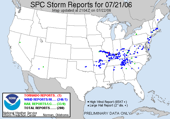
Figure 4: Storm reports for July 21st from the Storm Prediction Center
PRELIMINARY LOCAL STORM REPORT
NATIONAL WEATHER SERVICE CHARLESTON WV
FRIDAY JUL 21 2006

..TIME...   ...EVENT...      ...CITY LOCATION...     ...LAT.LON...
..DATE...   ....MAG....      ..COUNTY LOCATION..ST.. ...SOURCE....
            ..REMARKS..

0535 PM     TSTM WND DMG     3 N PHILIPPI            39.20N 80.04W
07/21/2006                   BARBOUR            WV   COUNTY OFFICIAL

            TREES DOWN ALONG ROUTE 119 IN HOPEWELL

0635 PM     HAIL             N WAYNE                 38.22N 82.44W
07/21/2006  E0.75 INCH       WAYNE              WV   PUBLIC

0640 PM     TSTM WND DMG     2 WSW HUNTINGTON        38.40N 82.47W
07/21/2006                   CABELL             WV   COUNTY OFFICIAL

            TREES DOWN AT UPPER END OF SPRING VALLEY.

0821 PM     HAIL             2 SE ULYSSES            37.93N 82.66W
07/21/2006  M0.75 INCH       LAWRENCE           KY   TRAINED SPOTTER

0615 PM     TSTM WND DMG     7 S HUNTINGTON          38.31N 82.43W
07/21/2006                   WAYNE              WV   PUBLIC

            TREES DOWN

1000 PM     TSTM WND DMG     MILTON                  38.43N 82.14W
07/21/2006                   CABELL             WV   FIRE DEPT/RESCUE

            SEVERAL TREES DOWN IN MILTON

1007 PM     TSTM WND DMG     5 W HAMLIN              38.28N 82.20W
07/21/2006                   LINCOLN            WV   LAW ENFORCEMENT

            SEVERAL TREES DOWN IN WEST HAMLIN

1037 PM     TSTM WND DMG     HURLEY                  37.42N 82.02W
07/21/2006                   BUCHANAN           VA   COUNTY OFFICIAL

            SEVERAL TREES DOWN IN HURLEY AND THE OAKWOOD AREAS

1106 PM     FLASH FLOOD      GRUNDY                  37.28N 82.10W
07/21/2006                   BUCHANAN           VA   LAW ENFORCEMENT

            3 TO 4 FEET OF WATER IN HOMES ALONG ROUTE 460 IN GRUNDY.

1106 PM     FLASH FLOOD      2 NNE ASHLAND           38.49N 82.63W
07/21/2006                   LAWRENCE           OH   EMERGENCY MNGR

            HOODS CREEK OUT OF ITS BANK. SEVERAL ROADS FLOODED IN THE
            WESTWOOD AREA WITH WATER IN HOMES.

$$

