Rainfall from Remnants of Hurricane Ivan
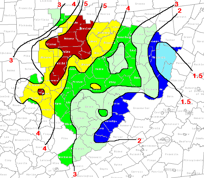
Total 48 hour precipitation (inches) from Ivan remnants through 7 AM September 18, 2004
Hurricane Ivan was a quite memorable storm in many respects. Born as a tropical depression on September 2nd in the tropical Atlantic, it reached hurricane status on the 5th. It eventually reached category 5 strength while passing over the Carribbean Sea. After causing widespread destruction over Grenada, Jamaica, and Cuba, it finally made landfall along coastal Alabama on September 16th as a category 3 storm.
As Ivan weakened and moved north, rainfall was seen across the Charleston forecast area on the 16th and 17th of September. The center of the weakening storm passed across eastern Tennessee late on the 16th, and then across southern West Virginia on the 17th. A slow moving cold front was sinking in from the northwest as Ivan's remnants moved through. This front acted as a focusing mechanism, allowing the heavier rainfall totals to fall along and near the Ohio River. When the rains finally subsided, the heaviest storm totals of 4 to 5 inches were seen in this area. Lesser amounts fell to the east, into the mountains. Here is a listing if the total rainfall amounts:
HERE ARE TWO DAY RAINFALL TOTALS ENDING AT 7 AM COLLECTED FROM AREA
CO-OP OBSERVERS AND IFLOW GAUGES FROM THE REMNANTS OF HURRICANE IVAN.

LOCATION            FRIDAY          SATURDAY        TOTAL

IN WEST VIRGINIA

HUNTINGTON ST. PARK 2.29            2.45            4.74
SPENCER             1.38            2.35            3.70
TORNADO             1.45            1.28            2.73
MADISON             1.41            1.07            2.48
WILLIAMSON          1.20            2.31            3.51
SNOWSHOE            0.10            2.47            2.57
VALLEY HEAD         0.12            2.02            2.14
BIRCH RIVER         0.53            3.76            4.29
LAKE FLOYD          0.40            2.80            3.20
BIG ISSAC W         0.56            2.80            3.36
NWS CHARLESTON      1.57            1.82            3.39
LOMI                1.08            1.60            2.68
BUFFALO MTN         1.08            2.35            3.43
BIRCH RIVER         0.48            3.63            4.11
RUTLEDGE                                            4.26

IN SOUTHEASTERN OHIO

ATHENS              0.74            4.35            5.09
NELSONVILLE         1.68            2.32            4.00
GALLIPOLIS          1.29            4.00            5.29
MCARTHUR            0.95            5.04            5.99
MARIETTA            0.52            4.27            4.79

IN NORTHEASTERN KENTUCKY

CHARLEY             2.40            1.88            4.28
OLIVE HILL          2.25            1.80            4.05
PRINCESS            2.63            2.64            5.27
CANNONSBURG         1.92            1.96            3.88
POTATO KNOB         2.08            2.48            4.56
SINKING CREEK       1.88            1.92            3.80
OLDTOWN             2.52            2.12            4.64
GREENUP EOC         1.16            2.80            3.96


IN SOUTHWESTERN VIRGINIA

CLINTWOOD           1.97            1.55            3.52
COUNCIL             1.24            1.28            2.52
CLINCHCO            1.84            1.84            3.68
With the ground already struggling to handle the rains from the remnants of Frances, these heavy rains caused numerous flooding problems. Most of the Ohio River counties reported many road closures and overflowing streams. All of this water eventually flowed into the Ohio River itself, which proved to be too much for the river to handle without flooding at several locations. One of these was Racine Lock, which recorded its highest stage ever. It recorded a crest just above 50 feet on Sunday, September 19th. The river finally receded back into its banks during the predawn hours of Wednesday the 22nd, with all points at or below flood stage.
Here are a few photos from the flood:
[361kb]Marietta, Ohio on September 20, the day after the Ohio crested at this location.
[381kb] Downtown Marietta. Note the store windows...the line of dirt illustrates how high a point the water reached at crest.
[53kb] Pomeroy, Ohio...also on September 20.
[61kb] Another view of Pomeroy.

