Event Summary
|
The first major severe weather outbreak of the season for the NWS Charleston County Warning Area (CWA) occurred during the late morning and early afternoon hours of Sunday, March 16th as a potent area of low pressure progressed through the Great Lakes region. Locally, thunderstorms quickly blossomed by mid Sunday morning along a prefrontal trough after brief clearing in advance of this feature provided just enough instability for thunderstorm development. Storms would quickly turn severe as they raced eastward fueled by strong winds aloft, swiftly building into a Quasi-Linear Convective System (QLCS) that would cause wind damage across much of the NWS Charleston CWA, even impacting areas well outside of our forecast area. Numerous reports of downed trees and power outages were received, along with some structural damage (some of which was significant). The strongest wind gust observed was 71 mph from the ASOS located at the North Central West Virginia Airport in Clarksburg, West Virginia. This was an all-time record maximum wind gust for the station, with wind gust records there dating back to 1974. In addition to the damaging winds, hail was reported in some areas, but mainly of the sub-severe variety. Please click on the tabs below for more detailed information about this event. Please note that all images/loops can be expanded by clicking on them. |
Radar loop courtesy of Iowa Environmental Mesonet (IEM) |
Text Summary of March 16th Wind Gusts Reports
Public Information Statement
National Weather Service Charleston WV
839 PM EDT Sun Mar 16 2025

...HIGHEST THUNDERSTORM WIND GUSTS...

Location                     Speed     Time/Date       Lat/Lon
Nutter Fort                  71 MPH    1210 PM 03/16   39.26N/80.32W
Clarksburg Airport           71 MPH    1215 PM 03/16   39.30N/80.22W
Waterford                    57 MPH    1213 PM 03/16   39.54N/81.68W
Logan                        52 MPH    1050 AM 03/16   37.85N/81.91W
Pennsboro                    52 MPH    1138 AM 03/16   39.27N/80.94W
Burr Oak                     52 MPH    1155 AM 03/16   39.59N/81.96W
Huntington Airport           49 MPH    0533 AM 03/16   38.37N/82.55W
Charleston Airport           46 MPH    1050 AM 03/16   38.38N/81.58W

...HIGHEST NON THUNDERSTORM WIND GUSTS...

Location                     Speed     Time/Date       Lat/Lon
Elkins Airport               52 MPH    0936 PM 03/15   38.88N/79.85W
Boyd Co EOC                  50 MPH    0525 AM 03/16   38.40N/82.74W
2 S Ceredo                   49 MPH    0409 AM 03/16   38.37N/82.55W
3 NW Beech Fork State Park   48 MPH    0330 AM 03/16   38.33N/82.46W
Beckley Airport              46 MPH    0232 PM 03/16   37.80N/81.12W

&&
All-Time Record Maximum Wind Gust Set at Clarksburg, West Virginia
RECORD EVENT REPORT
NATIONAL WEATHER SERVICE CHARLESTON WV
0353 PM EDT MON MAR 17 2025

...ALL-TIME RECORD MAXIMUM WIND GUST SET AT CLARKSBURG WV...

AN ALL-TIME RECORD WIND GUST OF 71 MPH WAS SET AT CLARKSBURG WV ON
SUNDAY, MARCH 16 AT 12:15 PM. THIS BREAKS THE OLD RECORD OF 67
MPH SET ON APRIL 10, 1991. WIND GUST RECORDS AT CLARKSBURG DATE BACK
TO 1974.

&&
Text Summary of March 16th Hail Reports
Preliminary Local Storm Report...Summary
National Weather Service Charleston WV
230 PM EDT Mon Mar 17 2025

...............HAIL REPORTS FROM SUNDAY, MARCH 16TH...............

..TIME...   ...EVENT...      ...CITY LOCATION...     ...LAT.LON...
..DATE...   ....MAG....      ..COUNTY LOCATION..ST.. ...SOURCE....
            ..REMARKS..

1044 AM     Hail             3 S South Charleston    38.32N 81.70W
03/16/2025  E0.50 Inch       Kanawha            WV   Public

            Report from mPING.

1047 AM     Hail             2 SW Charleston         38.34N 81.66W
03/16/2025  M0.70 Inch       Kanawha            WV   NWS Employee

            Mostly pea to half-inch, but a few larger
            ones. Peak wind gust 36mph.

1050 AM     Hail             1 SE Charleston         38.34N 81.62W
03/16/2025  E0.75 Inch       Kanawha            WV   Public

            Report from mPING.

1109 AM     Hail             Middlebourne            39.49N 80.90W
03/16/2025  M0.88 Inch       Tyler              WV   Public

            Time is estimated by radar.

1110 AM     Hail             4 SW Middlebourne       39.45N 80.97W
03/16/2025  M0.50 Inch       Tyler              WV   Trained Spotter

            Largest stones just under one half inch in
            diameter. Reported by Trained Spotter.

1122 AM     Hail             Middlebourne            39.50N 80.90W
03/16/2025  M1.00 Inch       Tyler              WV   Public

            Time is estimated by radar.

1224 PM     Hail             4 S Summersville        38.22N 80.85W
03/16/2025  M0.50 Inch       Nicholas           WV   Trained Spotter

&&
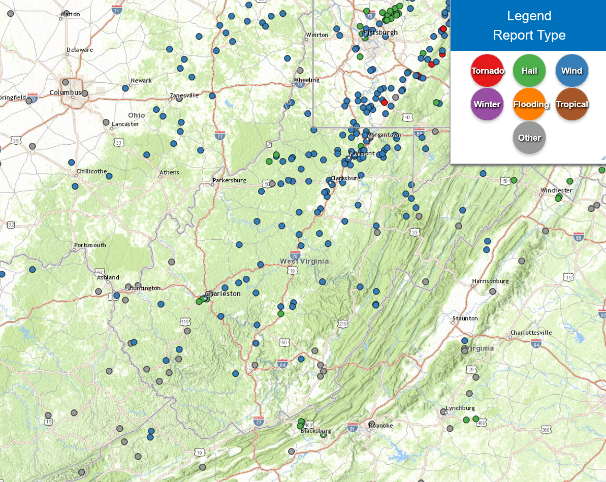
Map of March 16th Local Storm Reports
|
|
Please note that the map above includes some non thunderstorm wind gust and damage reports (grey dots) from late March 15th into the morning of March 16th associated with synoptic winds.
Map of March 15-17 Regional Storm Reports
|
|
Please note that the map above mainly encompasses storm reports from the afternoon of March 15th into the afternoon of March 17th, but does include some isolated reports outside of this time frame.
Text Summary of March 16th Local Storm Reports
Preliminary Local Storm Report...Summary
National Weather Service Charleston WV
253 PM EDT Mon Mar 17 2025
......THUNDERSTORM WIND DAMAGE REPORTS FROM SUNDAY, MARCH 16TH......
..TIME... ...EVENT... ...CITY LOCATION... ...LAT.LON...
..DATE... ....MAG.... ..COUNTY LOCATION..ST.. ...SOURCE....
..REMARKS..
0948 AM Tstm Wnd Dmg 10 NNE Kermit 37.99N 82.37W
03/16/2025 Wayne WV Park/Forest Srvc
Multiple trees reported down in Cabwaylingo
State Forest.
1000 AM Tstm Wnd Dmg 2 NNE Hamlin 38.30N 82.09W
03/16/2025 Lincoln WV 911 Call Center
Tree fell onto a cut a fiber line up Lower
Mud River Rd.
1040 AM Tstm Wnd Dmg 5 ENE Mitchell Heights 37.93N 81.90W
03/16/2025 Logan WV 911 Call Center
Tree down blocking Hewett Creek Rd.
1040 AM Tstm Wnd Dmg 1 WNW Charleston 38.35N 81.64W
03/16/2025 Kanawha WV 911 Call Center
Tree down blocking Kanawha Blvd at Clendenin
St.
1042 AM Tstm Wnd Dmg 1 S Mount Gay 37.84N 82.04W
03/16/2025 Logan WV 911 Call Center
Tree down blocking both lanes of Holden Rd.
1048 AM Tstm Wnd Dmg 5 E Haysi 37.21N 82.20W
03/16/2025 Buchanan VA Broadcast Media
Several trees reported down near the
community of Prater near Dickenson Highway.
1055 AM Tstm Wnd Dmg 5 WSW Grundy 37.26N 82.19W
03/16/2025 Buchanan VA Broadcast Media
Several trees reported down between Harman
and Prater.
1100 AM Tstm Wnd Dmg 10 NW Mcarthur 39.33N 82.63W
03/16/2025 Vinton OH 911 Call Center
Report of power poles down with lines in
roadway.
1100 AM Tstm Wnd Dmg 3 E Elkview 38.43N 81.43W
03/16/2025 Kanawha WV 911 Call Center
Trees down on Blue Creek Rd.
1102 AM Tstm Wnd Dmg 4 ESE Spencer 38.78N 81.28W
03/16/2025 Roane WV 911 Call Center
Several trees down east of Spencer,
including Arnoldsburg Rd, Steel Hollow Rd,
and Clay Rd.
1110 AM Tstm Wnd Dmg 3 ESE Clendenin 38.47N 81.29W
03/16/2025 Kanawha WV 911 Call Center
Trees down on Elk River Rd.
1110 AM Tstm Wnd Dmg 2 WSW East Bank 38.20N 81.47W
03/16/2025 Kanawha WV 911 Call Center
Trees down in Shrewsbury.
1115 AM Tstm Wnd Dmg 4 N Grantsville 38.97N 81.10W
03/16/2025 Calhoun WV 911 Call Center
Trees down north of Grantsville, including
Yellow Creek Rd, Leading Creek Rd and on W
Little Kanawha Hwy.
1116 AM Tstm Wnd Dmg 2 E West Union 39.29N 80.73W
03/16/2025 Doddridge WV 911 Call Center
Couple trees blown down near intersection of
Snowbird Rd and US 50.
1120 AM Tstm Wnd Dmg 11 N Clay 38.62N 81.06W
03/16/2025 Clay WV 911 Call Center
Tree down in Big Otter.
1120 AM Tstm Wnd Dmg 6 SSW Clay 38.39N 81.11W
03/16/2025 Clay WV 911 Call Center
Tree down in Bickmore.
1125 AM Tstm Wnd Dmg Harrisville 39.21N 81.05W
03/16/2025 Ritchie WV 911 Call Center
Multiple trees and powerlines down in and
around town.
1125 AM Tstm Wnd Dmg Procious 38.50N 81.21W
03/16/2025 Clay WV Public
Roof blown off of a structure.
1137 AM Tstm Wnd Dmg Middlebourne 39.49N 80.90W
03/16/2025 Tyler WV Postal Employee
A storm door was torn off the frame.
1140 AM Tstm Wnd Dmg Glenville 38.93N 80.84W
03/16/2025 Gilmer WV 911 Call Center
Numerous trees and powerlines down blocking
roads from Glenville to the Lewis Co line.
1141 AM Tstm Wnd Dmg 9 ESE Middlebourne 39.47N 80.74W
03/16/2025 Tyler WV 911 Call Center
Tree down on Walnut Fork Rd.
1141 AM Tstm Wnd Dmg 4 WSW West Union 39.27N 80.85W
03/16/2025 Doddridge WV 911 Call Center
Multiple trees down.
1142 AM Tstm Wnd Dmg 5 SE Middlebourne 39.45N 80.83W
03/16/2025 Tyler WV Dept of Highways
Tree reported down across the road near the
intersection of County Road 18 and Pitts
Run.
1145 AM Tstm Wnd Dmg West Union 39.30N 80.77W
03/16/2025 Doddridge WV 911 Call Center
Tree down blocking the road and fell on the
porch of a house.
1145 AM Tstm Wnd Dmg West Union 39.30N 80.77W
03/16/2025 Doddridge WV 911 Call Center
Trees down blocking Rt 18 in a couple of
places.
1145 AM Tstm Wnd Dmg 10 NNE Sand Fork 39.04N 80.66W
03/16/2025 Lewis WV 911 Call Center
Multiple trees and powerlines down including
Vadis Rd and Simms Run.
1146 AM Tstm Wnd Dmg 3 NNW Malta 39.69N 81.89W
03/16/2025 Morgan OH 911 Call Center
A couple trees reported down north of
McConnelsville.
1150 AM Tstm Wnd Dmg 10 E Middlebourne 39.48N 80.73W
03/16/2025 Tyler WV 911 Call Center
Tree reported down on Walnut Fork Road.
1150 AM Tstm Wnd Dmg Burnsville 38.86N 80.66W
03/16/2025 Braxton WV 911 Call Center
Trees down in Burnsville.
1155 AM Tstm Wnd Dmg 9 NNW Salem 39.39N 80.64W
03/16/2025 Doddridge WV Public
Trampoline blown away and lattice ripped
from a front porch of a home.
1157 AM Tstm Wnd Dmg 1 W Lester 37.73N 81.32W
03/16/2025 Raleigh WV 911 Call Center
Power lines down in Lester Community.
1200 PM Tstm Wnd Dmg 3 NNE Flatwoods 38.77N 80.64W
03/16/2025 Braxton WV 911 Call Center
Trees down in Flatwoods and Heaters.
1200 PM Tstm Wnd Dmg 2 ESE Oak Hill 37.98N 81.11W
03/16/2025 Fayette WV 911 Call Center
Tree down in the road.
1200 PM Tstm Wnd Dmg 4 WSW Craigsville 38.31N 80.72W
03/16/2025 Nicholas WV 911 Call Center
Tree down.
1200 PM Tstm Wnd Dmg 1 NE Salem 39.29N 80.56W
03/16/2025 Harrison WV 911 Call Center
Multiple trees and powerlines down between
West Union and Clarksburg.
1200 PM Tstm Wnd Dmg Summersville 38.28N 80.85W
03/16/2025 Nicholas WV 911 Call Center
Tree down.
1204 PM Tstm Wnd Dmg Clarksburg 39.28N 80.33W
03/16/2025 Harrison WV 911 Call Center
Multiple trees down in Clarksburg with the
roof blown off an apartment building.
1205 PM Tstm Wnd Dmg Weston 39.04N 80.47W
03/16/2025 Lewis WV 911 Call Center
Update to add information to previous
report. Wall from a building fell into the
roadway. Also, numerous trees and powerlines
down and across roads in town and over the
eastern end of the county.
1210 PM Tstm Wnd Dmg 2 ENE West Milford 39.21N 80.38W
03/16/2025 Harrison WV Public
Social Media post showing damage from the
Laurel Valley area, with siding ripped off
the wall of a house, and another house with
a partially collapsed wall. Also several
trees down, damaging fences.
1210 PM Tstm Wnd Dmg West Milford 39.20N 80.40W
03/16/2025 Harrison WV Public
A portion of a wall was ripped off the side
of a garage.
1210 PM Tstm Wnd Dmg 1 NW Lost Creek 39.17N 80.37W
03/16/2025 Harrison WV Trained Spotter
Storm door was torn off the frame on back
porch.
1210 PM Tstm Wnd Dmg 7 NNW Mcconnelsville 39.76N 81.88W
03/16/2025 Morgan OH Utility Company
Power company reports an outage caused by
tree damage.
1212 PM Tstm Wnd Dmg Ansted 38.13N 81.10W
03/16/2025 Fayette WV Utility Company
Power company reports a weather-related
outage in association with the thunderstorms
that moved through.
1215 PM Tstm Wnd Dmg 2 ENE Bridgeport 39.30N 80.22W
03/16/2025 Harrison WV ASOS
Corrects previous non-tstm wnd gst report
from 2 ENE Bridgeport. ASOS station KCKB
Clarksburg Airport.
1215 PM Tstm Wnd Dmg 1 NW Clarksburg 39.30N 80.35W
03/16/2025 Harrison WV Public
Uprooted trees, siding torn off of porch and
part of roof blown off house.
1215 PM Tstm Wnd Dmg 3 E Bridgeport 39.28N 80.21W
03/16/2025 Harrison WV Public
Structural damage and debris.
1215 PM Tstm Wnd Dmg 6 WNW Rock Cave 38.87N 80.45W
03/16/2025 Lewis WV 911 Call Center
Multiple trees and powerlines down blocking
roads across southern end of the county.
1230 PM Tstm Wnd Dmg 3 SSW Rock Cave 38.79N 80.36W
03/16/2025 Upshur WV 911 Call Center
Tree down blocking part of Rt 20.
1230 PM Tstm Wnd Dmg Grafton 39.34N 80.02W
03/16/2025 Taylor WV 911 Call Center
Multiple trees and lines down in and around
Grafton and countywide.
1230 PM Tstm Wnd Dmg 2 NE Weston 39.07N 80.44W
03/16/2025 Lewis WV Trained Spotter
One large hardwood tree uprooted and a
couple of large pine trees damaged.
1235 PM Tstm Wnd Dmg 5 SW Craigsville 38.28N 80.73W
03/16/2025 Nicholas WV Dept of Highways
Several trees reported down between
Summersville and Curtin.
1235 PM Tstm Wnd Dmg 3 S Philippi 39.10N 80.05W
03/16/2025 Barbour WV Amateur Radio
Tree damage, debris in the roadway.
1238 PM Tstm Wnd Dmg 2 SE Buckhannon 38.97N 80.19W
03/16/2025 Upshur WV 911 Call Center
Tree and phone line down across Phillips
Dairy Rd.
1252 PM Tstm Wnd Dmg 1 WSW Webster Springs 38.48N 80.42W
03/16/2025 Webster WV 911 Call Center
Tree down on Webster Rd over McGuire Mtn.
0115 PM Tstm Wnd Dmg 1 W Elkins 38.93N 79.86W
03/16/2025 Randolph WV Broadcast Media
Roof of the Phil Gainer Community Center
damaged by wind.
0155 PM Tstm Wnd Dmg 3 NW Snowshoe 38.44N 80.03W
03/16/2025 Pocahontas WV 911 Call Center
Tree down on Seneca Trail.
0239 PM Tstm Wnd Dmg 2 SW Greenbank 38.40N 79.86W
03/16/2025 Pocahontas WV CO-OP Observer
CO-OP observer in Dunmore reported multiple
trees down north of Dunmore along route 28.
Time estimated via radar.
0304 PM Tstm Wnd Dmg 9 SSW Greenbank 38.29N 79.87W
03/16/2025 Pocahontas WV Public
Local plant nursery along rt-92, north of
Frost reported a tree down on property about
a foot and a half in diameter. They also
advised there was some small hail in the
area. Time estimated by radar.
0304 PM Tstm Wnd Dmg 9 SSW Greenbank 38.30N 79.87W
03/16/2025 Pocahontas WV CO-OP Observer
CO-OP observer in Dunmore reported multiple
trees down between Dunmore and Frost on the
way to Lewisburg. Time estimated by radar.
&&
Preliminary Local Storm Report...Summary
National Weather Service Charleston WV
245 PM EDT Mon Mar 17 2025
....NON THUNDERSTORM WIND DAMAGE REPORTS FROM SUNDAY, MARCH 16TH....
..TIME... ...EVENT... ...CITY LOCATION... ...LAT.LON...
..DATE... ....MAG.... ..COUNTY LOCATION..ST.. ...SOURCE....
..REMARKS..
1238 AM Non-Tstm Wnd Dmg 10 SE Clintwood 37.05N 82.33W
03/16/2025 Dickenson VA 911 Call Center
Tree down and blocking on Dante Mountain Rd.
0250 AM Non-Tstm Wnd Dmg 1 E Danville 38.08N 81.82W
03/16/2025 Boone WV 911 Call Center
A tree fell on power lines and on an
unoccupied truck on Price Branch Rd.
0448 AM Non-Tstm Wnd Dmg 2 NNE Red Jacket 37.67N 82.11W
03/16/2025 Mingo WV 911 Call Center
Tree down about a quarter mile above Hannah
Lumber.
0501 AM Non-Tstm Wnd Dmg 4 SSW Switzer 37.74N 82.01W
03/16/2025 Logan WV 911 Call Center
Tree down blocking both sides of the road at
the top of Cow Creek Mountain.
0627 AM Non-Tstm Wnd Dmg 1 ENE Chesapeake 38.44N 82.43W
03/16/2025 Lawrence OH 911 Call Center
Large tree down and blocking County Rd 32.
0629 AM Non-Tstm Wnd Dmg 3 ENE Proctorville 38.45N 82.33W
03/16/2025 Lawrence OH 911 Call Center
Tree down with powerlines along Township Rd
1244.
0700 AM Non-Tstm Wnd Dmg 5 NNE Chattaroy 37.77N 82.24W
03/16/2025 Mingo WV 911 Call Center
Tree reported down blocking one lane of
traffic.
0749 AM Non-Tstm Wnd Dmg 2 NNW Clintwood 37.17N 82.47W
03/16/2025 Dickenson VA 911 Call Center
Tree reported down near the intersection of
Brush Creek Road and Stone Holw.
0812 AM Non-Tstm Wnd Dmg 10 N Kermit 37.98N 82.40W
03/16/2025 Wayne WV 911 Call Center
Tree reported down near the intersection of
Route 152 and Sand Lick Road.
&&
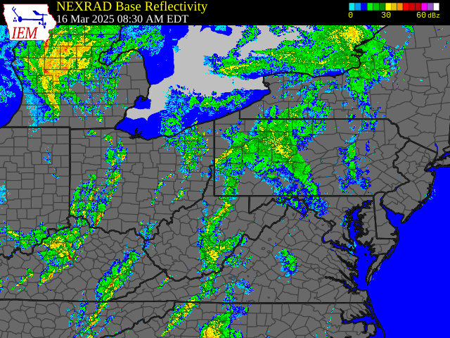
March 16th Time Synchronized Local/Regional Radar Loops
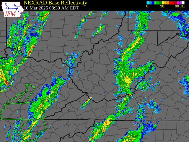 |
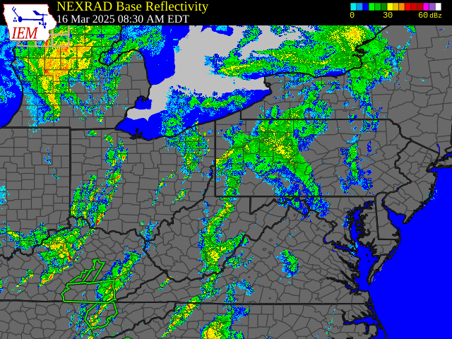 |
|
March 16th Local Radar Loop (w/ Warnings Overlaid: Yellow - Severe Thunderstorm, Red - Tornado, Green - Flash Flood) Radar loop courtesy of Iowa Environmental Mesonet (IEM) |
March 16th Regional Radar Loop (w/ Warnings Overlaid: Yellow - Severe Thunderstorm, Red - Tornado, Green - Flash Flood) Radar loop courtesy of Iowa Environmental Mesonet (IEM) |
March 16th Time Synchronized Regional Satellite Loops
 |
 |
|
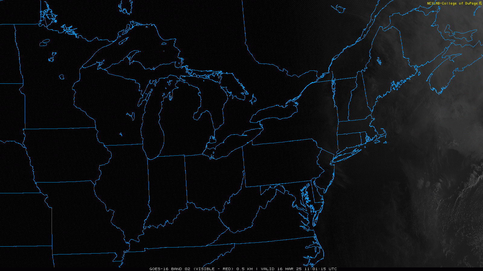
March 16th Visible Loop (GOES-16) Satellite loop courtesy of NEXLAB - College of Dupage |
March 16th Infrared Loop (GOES-16) Satellite loop courtesy of NEXLAB - College of Dupage |
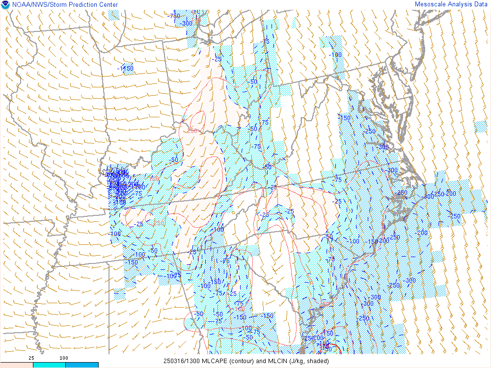
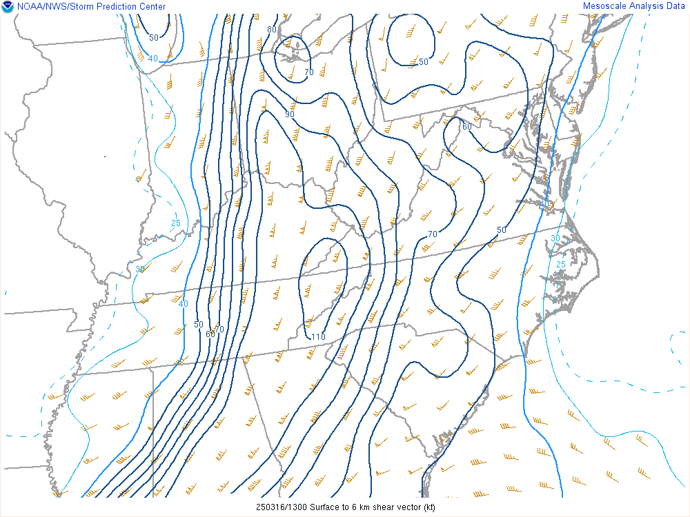
March 16th Surface/Upper Air Maps and Severe Weather Parameters
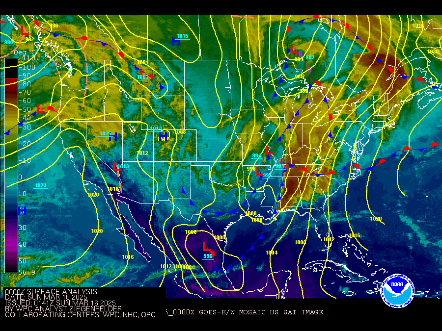
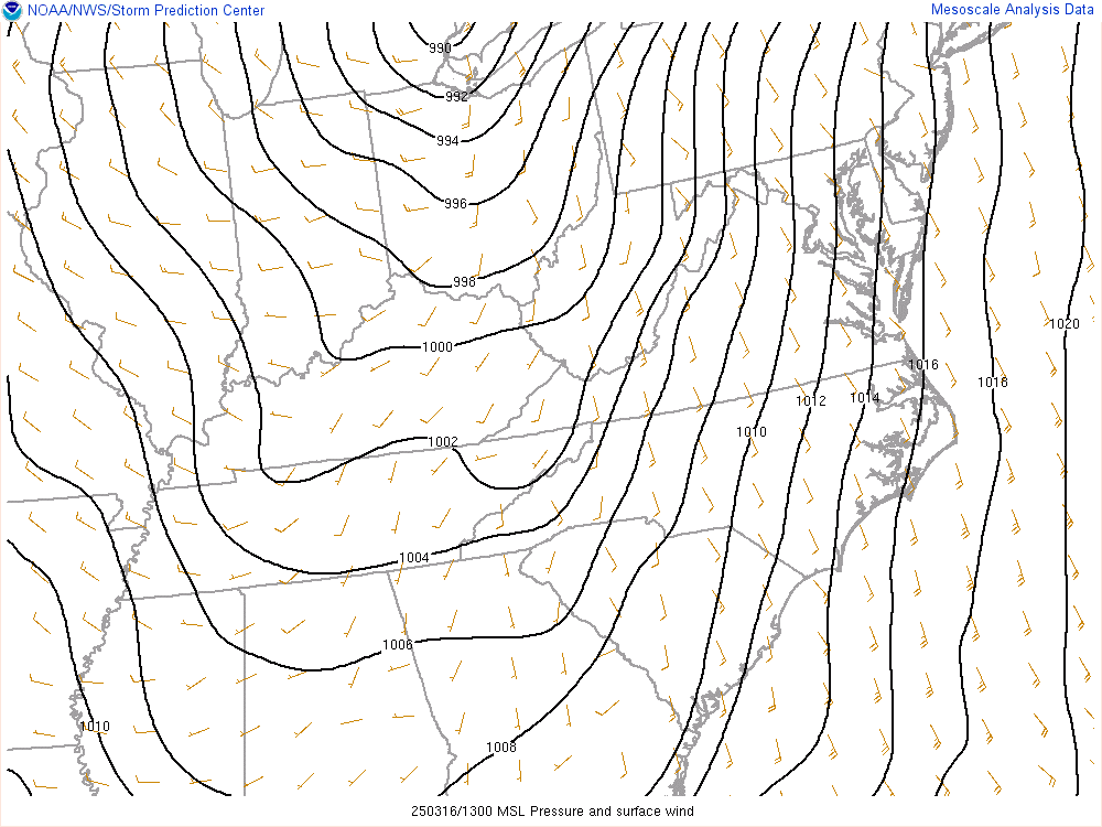
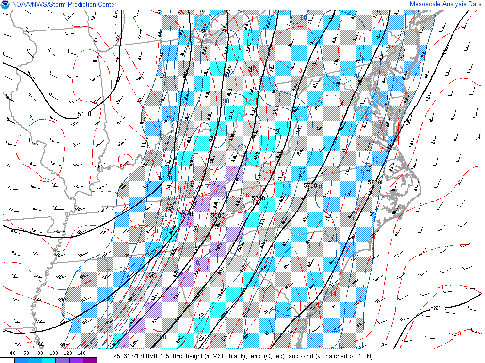
The regional loops below run from 9 AM March 16th until 6 PM March 16th and are time synchronized. The infrared satellite loop w/ surface analysis overlay runs from 8 PM March 15th until 11 PM March 16th and is at 3-hr intervals. All loops are in Coordinated Universal Time (UTC or Z), which is a 4-hr offset from EDT (for example - 1200Z is equivalent to 8 AM EDT).
 |
 |
 |
|
Infrared Satellite w/ Surface Analysis Overlay Loop Credit: Weather Prediction Center |
Mean Sea Level Pressure and Surface Wind Loop Credit: Storm Prediction Center |
850 mb Analysis Loop Credit: Storm Prediction Center |
 |
 |
 |
|
700 mb Analysis Loop Credit: Storm Prediction Center |
500 mb Analysis Loop Credit: Storm Prediction Center |
300 mb Analysis Loop Credit: Storm Prediction Center |
 |
 |
 |
|
CAPE - 100mb Mixed-Layer Loop Credit: Storm Prediction Center |
Bulk Shear - Sfc-6km Loop Credit: Storm Prediction Center |
Storm Relative Helicity - Sfc-3km Loop Credit: Storm Prediction Center |
 |
Media use of NWS Web News Stories is encouraged! Please acknowledge the NWS as the source of any news information accessed from this site. |
|