Event Summary
|
Hurricane Helene made landfall as a Category 4 hurricane in the Florida Big Bend region at approximately 11:10 PM EDT on Thursday, September 26th just east of the mouth of the Aucilla River, which is about 10 miles west-southwest of Perry, Florida. Based on data from Air Force reconnaissance aircraft, the maximum sustained winds were estimated to be 140 mph and the minimum central pressure at 938 mb (27.70 inches). From there Hurricane Helene would continue to rapidly move northward as it continued to be influenced by an upper trough across the eastern CONUS, with its center being located near Knoxville/Morristown Tennessee at 11:00 AM EDT on Friday, September 27th only 12 hours later, leaving a path of significant to catastrophic flooding and wind damage as it moved northward. By this time, the NWS Charleston County Warning Area (CWA) had begun to see noteworthy impacts from Helene (downgraded to a tropical storm by this point), with wind gusts of 50 mph occurring across portions of the far southern CWA, as well as locally heavy rain. The 8:00 AM EDT (12Z) upper air sounding from Greensboro, North Carolina would foreshadow the intense wind field set to impact portions of the area later in the day, with winds of 60 knots (69 mph) measured just 5,600 feet above ground level there! Helene would quickly deviate its track to the west-northwest as it began to pivot around an increasingly cut off upper-level low, moving from southeast Kentucky to near Louisville, Kentucky by 6:00 PM EDT on Friday, September 27th, gradually becoming post-tropical as it did so. This time period coincided with the most intense impacts across the NWS Charleston CWA, with strong to damaging wind gusts occurring across much of the CWA, along with locally heavy rain that resulted in isolated flash flooding. Overall, the greatest impacts were felt across the southern and western portion of the CWA, including southwest Virginia, southern and west-central West Virginia, northeast Kentucky, and portions of southeast Ohio. Wind gusts of 50-60+ mph were not uncommon in these locations, as Helene's heavy rainbands helped to bring strong low-level winds to the surface. Northeast Kentucky and far southern Ohio were hit by far the hardest in terms of rainfall, with rain totals of 2-5"+ in some locations. The highest wind gust recorded was 70 mph at the Automated Surface Observing System (ASOS) at the Huntington (WV) Tri-State Airport, the second highest gust ever recorded at the station! The intense wind gusts associated with the remnants of Helene resulted in numerous trees down across the area, and even some structural damage. It should be noted that locally heavy, but mainly beneficial rainfall occurred in advance of Helene from late Wednesday, September 25th into the early Friday, September 27th in the form of a Predecessor Rain Event (PRE), with even a tornado occurring during the evening of September 25th in Pocahontas County (WV). This was the first documented tornado to occur in Pocahontas County - see here Please click on the tabs below for more detailed information about this event. Please note that all images/loops can be expanded by clicking on them. |
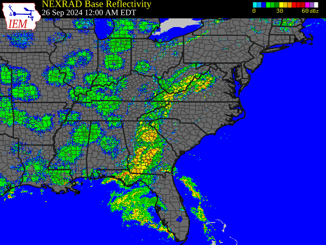
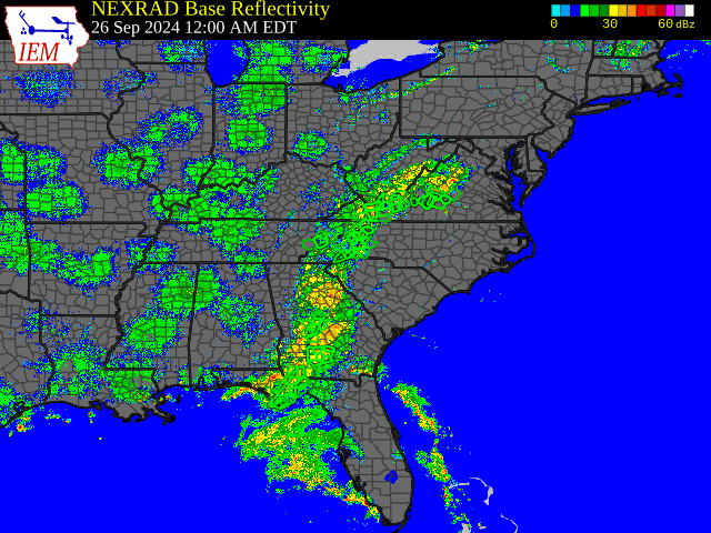
Radar loop courtesy of Iowa Environmental Mesonet (IEM)
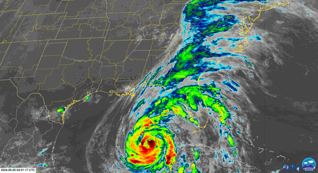
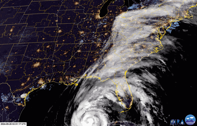
Satellite loop courtesy of RAMMB-CIRA
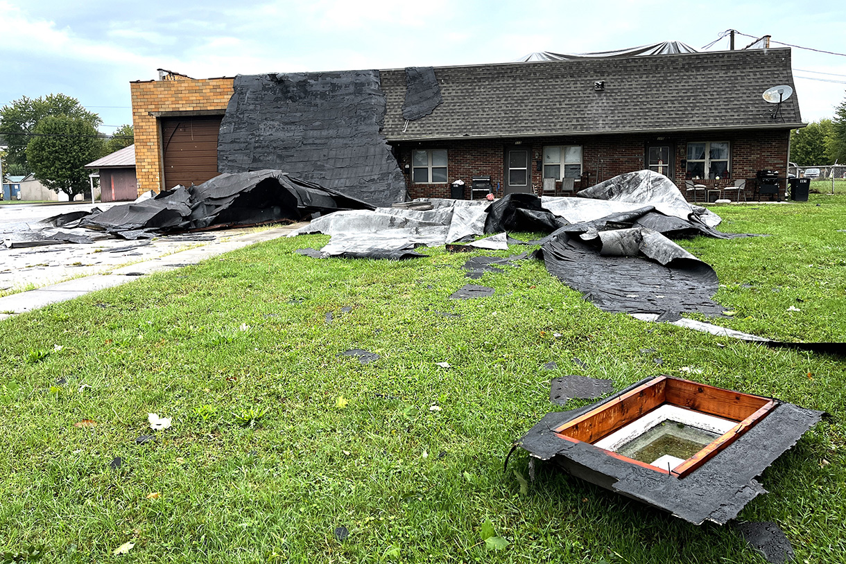
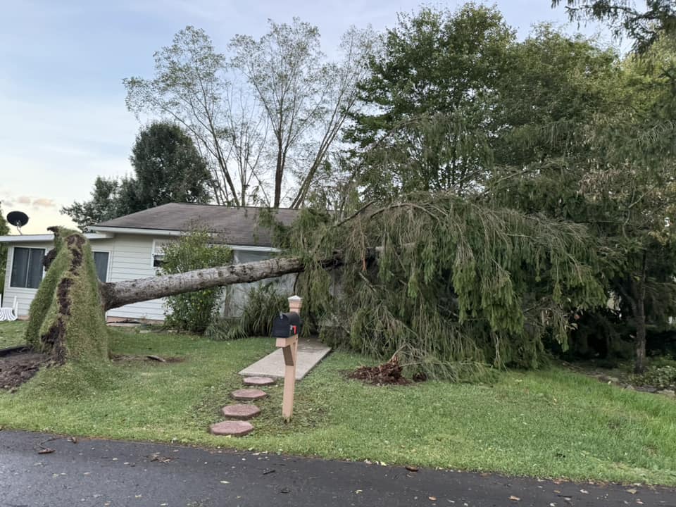
Telegram Photo by Jeremiah Shaver |
September 26-27 Time Synchronized Local/Regional Radar Loops
 |
 |
|
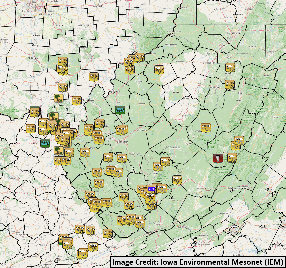
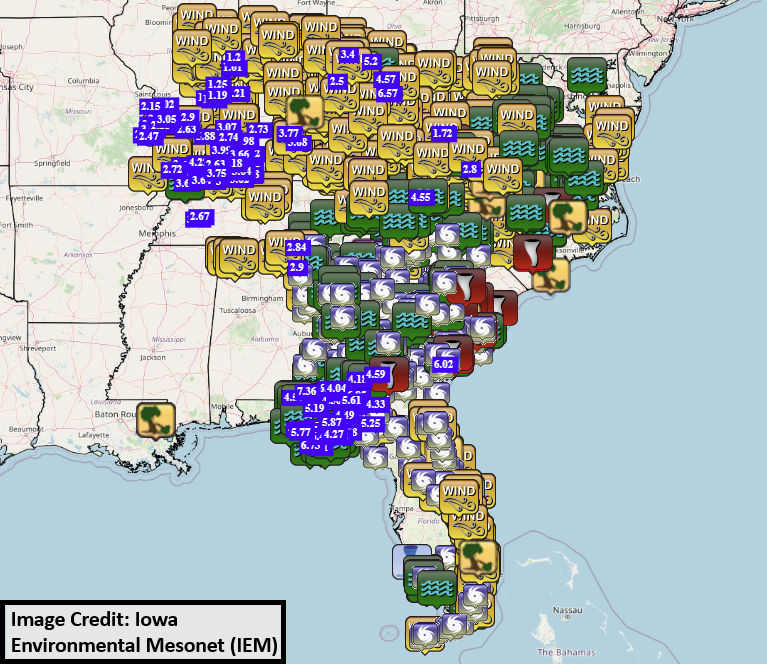
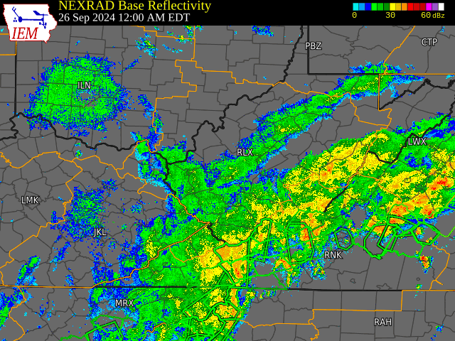
September 26-27 Local Radar Loop (w/ Warnings Overlaid: Green - Flash Flood, Yellow - Severe Thunderstorm, Red - Tornado) Radar loop courtesy of Iowa Environmental Mesonet (IEM) |
September 26-27 Regional Radar Loop (w/ Warnings Overlaid: Green - Flash Flood, Yellow - Severe Thunderstorm, Red - Tornado) Radar loop courtesy of Iowa Environmental Mesonet (IEM) |
September 26-27 Regional Satellite Loops
 |
 |
|
September 26-27 Infrared Loop (GOES-16) Satellite loop courtesy of RAMMB-CIRA |
September 26-27 GeoColor Loop (GOES-16) Satellite loop courtesy of RAMMB-CIRA |
Text Summary of Reported Wind Gusts on September 27th
Public Information Statement
National Weather Service Charleston WV

....SEPTEMBER 27th, 2024 REPORTED WIND GUSTS (35 MPH AND GREATER)....

Location                     Speed     Time/Date       Lat/Lon

...Kentucky...

...Boyd County...
Ashland                      51 MPH    0105 PM 09/27   38.40N/82.74W

...Greenup County...
Ashland Airport              37 MPH    0259 PM 09/27   38.55N/82.73W

...Lawrence County...
Louisa 1 S                   43 MPH    1240 PM 09/27   38.10N/82.60W

...Ohio...

...Athens County...
Athens Airport               43 MPH    0115 PM 09/27   39.22N/82.23W

...Jackson County...
4 SE Jackson                 51 MPH    0258 PM 09/27   38.98N/82.58W

...Lawrence County...
8 ENE Coal Grove             63 MPH    0130 PM 09/27   38.54N/82.51W

...Morgan County...
Burr Oak                     35 MPH    0335 PM 09/27   39.59N/81.96W

...Washington County...
Marietta                     38 MPH    0313 PM 09/27   39.35N/81.57W
Waterford                    35 MPH    0314 PM 09/27   39.54N/81.68W

...West Virginia...

...Barbour County...
Laurel Mountain Lkt          48 MPH    0518 PM 09/27   39.00N/79.89W

...Braxton County...
Dingy                        35 MPH    0103 PM 09/27   38.64N/80.93W

...Cabell County...
Huntington                   49 MPH    0225 PM 09/27   38.42N/82.44W

...Harrison County...
Clarksburg Airport           39 MPH    0339 PM 09/27   39.30N/80.22W

...Kanawha County...
Charleston Airport           39 MPH    0129 PM 09/27   38.38N/81.58W


...Lewis County...
Camden                       41 MPH    0638 AM 09/27   39.03N/80.56W

...Logan County...
Logan                        50 MPH    0414 PM 09/27   37.85N/81.91W
Logan Cnty Airport           40 MPH    1255 PM 09/27   37.85N/81.92W

...Mason County...
Lakin                        41 MPH    0316 PM 09/27   38.96N/82.09W

...McDowell County...
Elkhorn                      54 MPH    1217 PM 09/27   37.40N/81.54W

...Nicholas County...
Poe North                    40 MPH    0202 PM 09/27   38.26N/80.96W

...Pocahontas County...
Snowshoe                     40 MPH    0125 PM 09/27   38.42N/79.99W

...Putnam County...
Hurricane                    41 MPH    0120 PM 09/27   38.42N/82.03W

...Raleigh County...
Beckley Airport              53 MPH    1225 PM 09/27   37.80N/81.12W
Beckley (Turnpike)           44 MPH    0115 PM 09/27   37.80N/81.21W
Grandview                    37 MPH    0105 PM 09/27   37.83N/81.07W

...Randolph County...
Sugar Run                    38 MPH    1220 PM 09/27   38.73N/80.02W
Harmon                       36 MPH    0137 PM 09/27   38.97N/79.53W
Mill Creek                   35 MPH    1140 AM 09/27   38.73N/79.98W

...Roane County...
Spencer                      46 MPH    0456 PM 09/27   38.80N/81.36W

...Wayne County...
Huntington Airport           70 MPH    1211 PM 09/27   38.37N/82.55W
Wayne                        37 MPH    0130 PM 09/27   38.33N/82.46W
Wayne                        36 MPH    1245 PM 09/27   38.09N/82.48W
Wayne                        35 MPH    0215 PM 09/27   38.22N/82.44W

...Webster County...
Spring Ridge                 41 MPH    0356 AM 09/27   38.47N/80.42W

...Wood County...
Parkersburg Airport          43 MPH    0326 PM 09/27   39.35N/81.42W

&&
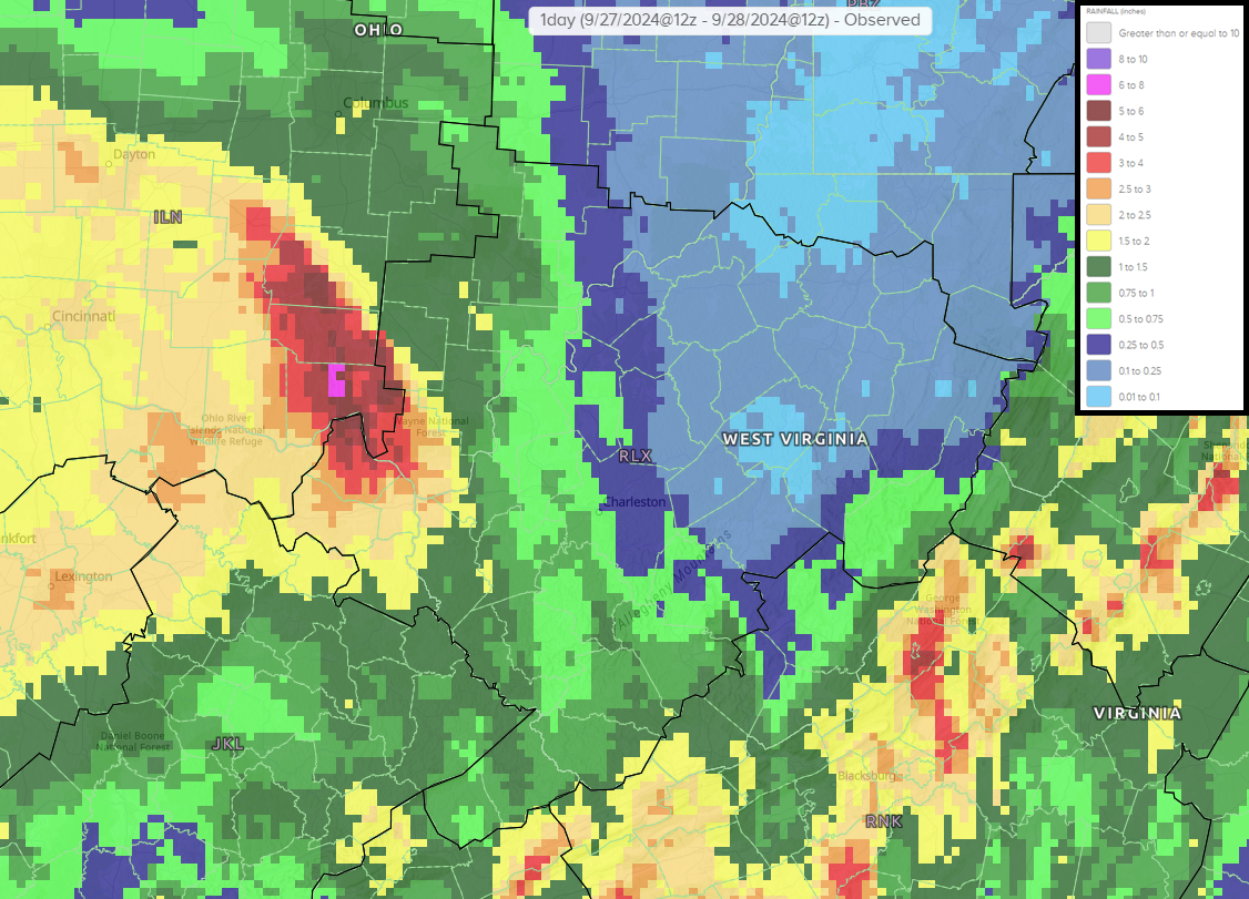
September 27th (8 AM) to September 28th (8 AM) Rainfall Totals
|
|
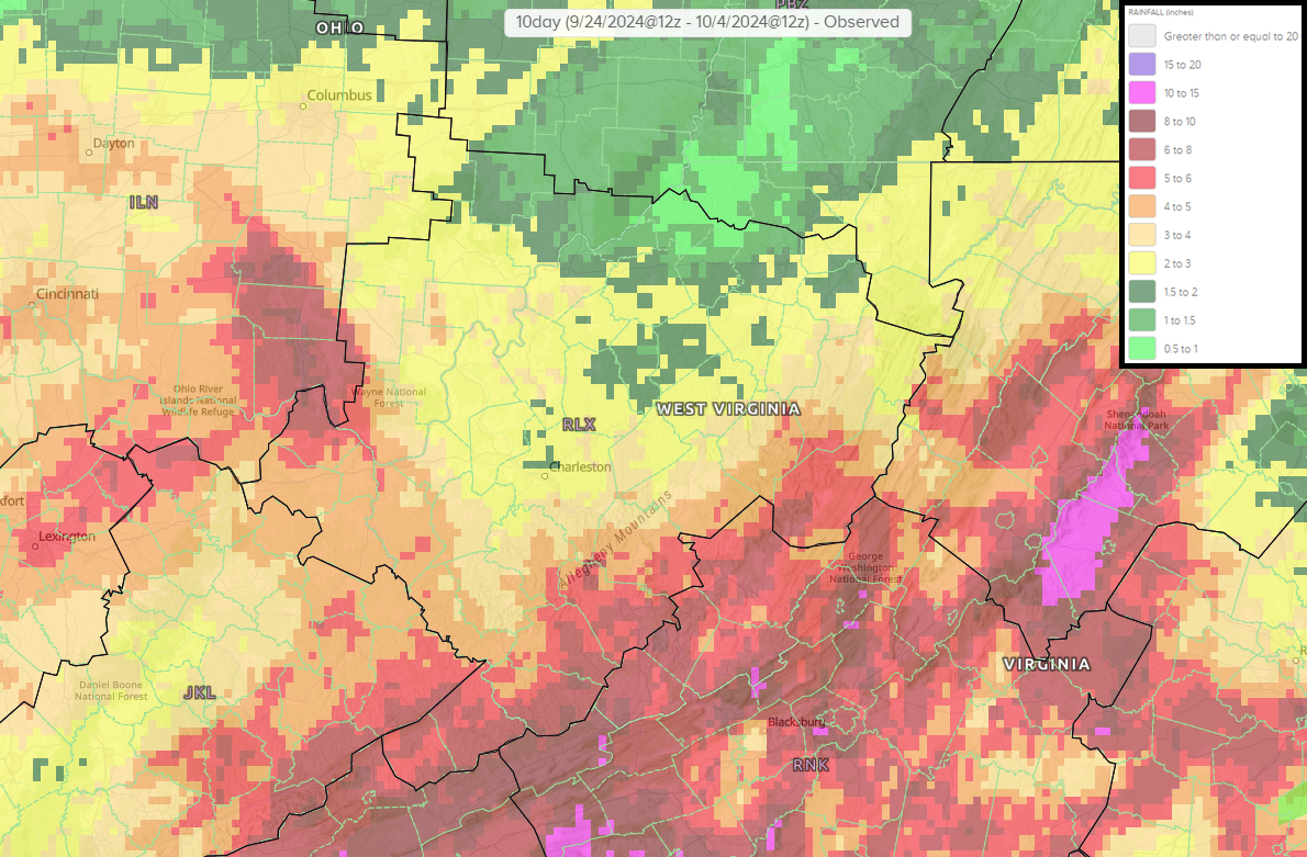
September 24th (8 AM) to October 4th (8 AM) Rainfall Totals
|
|
This rainfall map encapsulates the Predecessor Rain Event (PRE) in advance of Helene, the rainfall as Helene tracked southwest of the area, along with the rainfall as the remnants of Helene continued to dissipate over the following days across the region. Additionally, it should be noted that this map does include some rainfall from September 24th into September 25th in advance of the PRE.
Map of Local Storm Reports Associated with Helene (September 25-29)
|
|
Map of Regional Storm Reports Associated with Helene (Sept. 25 - Oct. 1)
|
|
Text Summary of September 25-29 Local Storm Reports
Preliminary Local Storm Report...Summary
National Weather Service Charleston WV
1039 PM EDT Sat Oct 5 2024
....SEPTEMBER 25-29, 2024 STORM REPORTS ASSOCIATED WITH HELENE....
..TIME... ...EVENT... ...CITY LOCATION... ...LAT.LON...
..DATE... ....MAG.... ..COUNTY LOCATION..ST.. ...SOURCE....
..REMARKS..
0611 PM Tornado 1 NE Hillsboro 38.15N 80.20W
09/25/2024 Pocahontas WV Public
0816 PM Rain 1 W Beckley 37.79N 81.20W
09/25/2024 M1.72 Inch Raleigh WV Trained Spotter
0536 PM Rain 1 W Beckley 37.79N 81.20W
09/26/2024 M1.73 Inch Raleigh WV Public
Reported by Trained Spotter.
0909 AM Non-Tstm Wnd Dmg 5 SE Northfork 37.37N 81.37W
09/27/2024 McDowell WV 911 Call Center
Tree and power lines down along route 52 on
Tank Hill.
0930 AM Non-Tstm Wnd Dmg Oceana 37.69N 81.62W
09/27/2024 Wyoming WV Utility Company
Power outages caused by tree and line damage
began as early as 930 am, peaking around 330
pm with more than 50% of served households
losing power.
0934 AM Non-Tstm Wnd Dmg 2 S Welch 37.41N 81.58W
09/27/2024 McDowell WV 911 Call Center
Three trees down.
0939 AM Non-Tstm Wnd Dmg 1 WNW Crab Orchard 37.75N 81.25W
09/27/2024 Raleigh WV 911 Call Center
Tree and power lines down.
1000 AM Non-Tstm Wnd Dmg 3 ENE Meadow Bridge 37.89N 80.81W
09/27/2024 Fayette WV Utility Company
Tree damage caused power outages began as
early as 10 am. By early afternoon
approximately 15% of served households in
the county lost power, most of which was in
the eastern half of the county.
1001 AM Non-Tstm Wnd Gst 2 S Ceredo 38.37N 82.55W
09/27/2024 M41 MPH Wayne WV ASOS
ASOS station KHTS Huntington Airport.
1024 AM Non-Tstm Wnd Gst 2 ESE Stanaford 37.80N 81.12W
09/27/2024 M51 MPH Raleigh WV ASOS
ASOS station KBKW Beckley Airport.
1030 AM Non-Tstm Wnd Dmg 10 SW Davenport 37.00N 82.25W
09/27/2024 Dickenson VA 911 Call Center
20 or more trees down on Dante Mountain
Road.
1030 AM Non-Tstm Wnd Dmg 13 E Vansant 37.25N 81.86W
09/27/2024 Buchanan VA 911 Call Center
Trees down on Pilgrims Knob and Gibson Ridge
Rd.
1100 AM Non-Tstm Wnd Dmg 2 SSW Clintwood 37.12N 82.47W
09/27/2024 Dickenson VA 911 Call Center
Trees down in Clintwood and on Rockhouse Rd.
1100 AM Non-Tstm Wnd Dmg 7 SW Davenport 37.02N 82.23W
09/27/2024 Dickenson VA Public
Widespread uprooted trees in swaths on Hazel
Mountain Road.
1106 AM Non-Tstm Wnd Dmg 1 WSW Beckley 37.78N 81.20W
09/27/2024 Raleigh WV 911 Call Center
Tree on powerlines and blocking road.
1113 AM Non-Tstm Wnd Dmg 7 SE Red Jacket 37.56N 82.06W
09/27/2024 Mingo WV 911 Call Center
Trees and power lines down.
1121 AM Non-Tstm Wnd Dmg Kimball 37.43N 81.51W
09/27/2024 McDowell WV 911 Call Center
Tree fell on car.
1132 AM Non-Tstm Wnd Dmg Lester 37.74N 81.30W
09/27/2024 Raleigh WV Public
Tree and power lines down.
1132 AM Non-Tstm Wnd Dmg 1 NNW Coal City 37.69N 81.22W
09/27/2024 Raleigh WV 911 Call Center
Tree has fallen on a mobile home. Roof has
caved in.
1145 AM Non-Tstm Wnd Dmg 7 ESE Red Jacket 37.61N 82.02W
09/27/2024 Mingo WV 911 Call Center
Trees and power lines down on Beech Creek
Rd.
1151 AM Non-Tstm Wnd Gst 2 S Ceredo 38.37N 82.55W
09/27/2024 M49 MPH Wayne WV ASOS
ASOS station KHTS Huntington Airport.
1155 AM Non-Tstm Wnd Dmg 4 ESE Davenport 37.09N 82.08W
09/27/2024 Buchanan VA 911 Call Center
Tree down blocking both lanes of Campground
Rd.
1200 PM Non-Tstm Wnd Dmg Kimball 37.43N 81.51W
09/27/2024 McDowell WV Fire Dept/Rescue
Approximately 75 trees down on US 52, many
of them very large.
1200 PM Non-Tstm Wnd Dmg Logan 37.85N 81.99W
09/27/2024 Logan WV 911 Call Center
Multiple trees down across the county,
including WV-44, Knights Landing Rd and
Kings Shoals Rd.
1211 PM Non-Tstm Wnd Dmg 4 S Madison 38.00N 81.81W
09/27/2024 Boone WV 911 Call Center
Tree down on Spruce River Rd.
1211 PM Non-Tstm Wnd Gst 2 S Ceredo 38.37N 82.55W
09/27/2024 M70 MPH Wayne WV ASOS
ASOS station KHTS Huntington Airport.
1213 PM Non-Tstm Wnd Dmg 1 E Northfork 37.42N 81.40W
09/27/2024 McDowell WV 911 Call Center
Tree and power lines down.
1217 PM Non-Tstm Wnd Gst 3 SW Kimball 37.40N 81.54W
09/27/2024 M54 MPH McDowell WV Mesonet
Mesonet station BRWW2 Elkhorn gusting to 54
mph last hour.
1217 PM Non-Tstm Wnd Dmg 1 W Chesapeake 38.43N 82.47W
09/27/2024 Lawrence OH 911 Call Center
Tree down on the roof of a residence.
1225 PM Non-Tstm Wnd Gst 2 ESE Stanaford 37.80N 81.12W 09/27/2024 M52 MPH Raleigh WV ASOS
ASOS station KBKW Beckley Airport reported
a new peak gust of 52 mph.
1225 PM Non-Tstm Wnd Dmg 1 NNE Sophia 37.72N 81.25W
09/27/2024 Raleigh WV 911 Call Center
Tree fell and hit a vehicle on Robert C Byrd
Drive. Windshield is busted.
1230 PM Non-Tstm Wnd Dmg 1 N Russell 38.52N 82.70W
09/27/2024 Greenup KY 911 Call Center
Trees down at Ferry St and High St and on
Berkshire Lane.
1231 PM Non-Tstm Wnd Dmg 5 SSE Hurricane 38.37N 81.99W
09/27/2024 Putnam WV 911 Call Center
Tree down on Kellys Creek Rd.
1235 PM Non-Tstm Wnd Dmg 2 S South Shore 38.69N 82.96W
09/27/2024 Greenup KY 911 Call Center
Trees down.
1248 PM Non-Tstm Wnd Dmg 4 SE Ceredo 38.36N 82.51W
09/27/2024 Wayne WV Public
Report from mPING: 3-inch tree limbs broken;
Power poles broken.
1249 PM Non-Tstm Wnd Dmg 1 NE Breaks Interstate 37.30N 82.28W
09/27/2024 Buchanan VA 911 Call Center
Tree and power lines down at Breaks Rd and
Commissioner Circle.
1255 PM Non-Tstm Wnd Gst 2 S Ceredo 38.37N 82.55W
09/27/2024 M62 MPH Wayne WV ASOS
ASOS station KHTS Huntington Airport. A
number of mPING reports showing damage as
well.
1258 PM Non-Tstm Wnd Dmg 1 SW South Point 38.41N 82.58W
09/27/2024 Lawrence OH Public
Report from mPING: 1-inch tree limbs broken;
Shingles blown off.
0100 PM Non-Tstm Wnd Dmg 1 ESE Sissonville 38.49N 81.63W
09/27/2024 Kanawha WV 911 Call Center
Large tree down with power lines.
0100 PM Non-Tstm Wnd Dmg Chesapeake 38.43N 82.45W
09/27/2024 Lawrence OH Broadcast Media
Tree down on power lines and apartment
building.
0100 PM Non-Tstm Wnd Dmg 10 NNE Carter Caves Sta 38.50N 83.02W
09/27/2024 Greenup KY CO-OP Observer
Several trees down across Denstar Farm Rd,
unable to get out to the main road.
0100 PM Non-Tstm Wnd Dmg 1 N Ashland 38.48N 82.65W
09/27/2024 Boyd KY Emergency Mngr
Numerous trees down including 39th St and
Shadowlawn Drive.
0105 PM Non-Tstm Wnd Gst 2 S Ceredo 38.37N 82.55W
09/27/2024 M56 MPH Wayne WV ASOS
ASOS station KHTS Huntington Airport.
0112 PM Non-Tstm Wnd Dmg 6 E Fort Gay 38.12N 82.49W
09/27/2024 Wayne WV 911 Call Center
Roof blown off a home on Hampton Ridge.
0115 PM Non-Tstm Wnd Dmg South Point 38.42N 82.57W
09/27/2024 Lawrence OH 911 Call Center
Numerous trees down in South Point including
west bound lane of US 52, Township Rd 268,
County Rd 17, and County Road 1.
0115 PM Non-Tstm Wnd Dmg 4 NW Chesapeake 38.46N 82.50W
09/27/2024 Lawrence OH 911 Call Center
Tree down on a garage.
0116 PM Non-Tstm Wnd Dmg 3 N Milton 38.47N 82.14W
09/27/2024 Cabell WV Public
Report from mPING: 1-inch tree limbs broken;
Shingles blown off.
0125 PM Non-Tstm Wnd Dmg 5 N Milton 38.50N 82.15W
09/27/2024 Cabell WV Public
Report from mPING: Trees uprooted or
snapped.
0126 PM Non-Tstm Wnd Dmg 1 N Parkersburg 39.28N 81.54W
09/27/2024 Wood WV 911 Call Center
Tree down on a car, no injuries.
0130 PM Non-Tstm Wnd Gst 8 ENE Coal Grove 38.54N 82.51W
09/27/2024 M63 MPH Lawrence OH Public
Highest gust observed at Dickess Christmas
Tree Farm. Multiple gusts up to 59 mph. Over
500 Christmas trees blown over.
0130 PM Non-Tstm Wnd Dmg Ironton 38.53N 82.69W
09/27/2024 Lawrence OH Public
State Rt 243, State Rt 650, Lawrence St & N
6th St, Maple Ave, and Township Rd 138.
0135 PM Non-Tstm Wnd Dmg Kenova 38.40N 82.58W
09/27/2024 Wayne WV 911 Call Center
Carport blown over on Barger Hill Rd and
trees and power lines down on Sycamore St
and 20th St.
0135 PM Non-Tstm Wnd Dmg 5 N Milton 38.50N 82.15W
09/27/2024 Cabell WV Public
Report from mPING: Trees uprooted or
snapped.
0143 PM Non-Tstm Wnd Dmg 2 SW Sissonville 38.48N 81.66W
09/27/2024 Kanawha WV Public
Report from mPING: 1-inch tree limbs broken;
Shingles blown off.
0147 PM Non-Tstm Wnd Dmg Gilbert 37.62N 81.87W
09/27/2024 Mingo WV 911 Call Center
Multiple trees down in Horsepen.
0148 PM Non-Tstm Wnd Dmg 1 SW South Point 38.41N 82.58W
09/27/2024 Lawrence OH Public
Report from mPING: 1-inch tree limbs broken;
Shingles blown off.
0159 PM Non-Tstm Wnd Dmg 1 N Hamden 39.18N 82.53W
09/27/2024 Vinton OH Public
Report from mPING: 1-inch tree limbs broken;
Shingles blown off.
0200 PM Non-Tstm Wnd Dmg Wayne 38.22N 82.44W
09/27/2024 Wayne WV 911 Call Center
Tree down at Ardel Rd and Rt 152.
0201 PM Non-Tstm Wnd Dmg 1 NW Proctorville 38.45N 82.40W
09/27/2024 Lawrence OH Public
Report from mPING: 1-inch tree limbs broken;
Shingles blown off.
0210 PM Non-Tstm Wnd Dmg 6 SE Jackson 38.99N 82.54W
09/27/2024 Jackson OH NWS Employee
Numerous trees down blocking US 35 with
multiple overturned semis.
0211 PM Non-Tstm Wnd Dmg 1 SSW Coal City 37.66N 81.22W
09/27/2024 Raleigh WV 911 Call Center
Tree fell on vehicle, no injuries.
0212 PM Non-Tstm Wnd Dmg 1 NE Mabscott 37.78N 81.20W
09/27/2024 Raleigh WV 911 Call Center
Tree fell on a vehicle, no injuries.
0212 PM Non-Tstm Wnd Dmg 3 WNW Mcarthur 39.26N 82.54W
09/27/2024 Vinton OH 911 Call Center
Tree down on power lines.
0212 PM Non-Tstm Wnd Dmg 4 NW Mcarthur 39.29N 82.54W
09/27/2024 Vinton OH 911 Call Center
Tree on power lines.
0215 PM Non-Tstm Wnd Dmg Hurricane 38.43N 82.02W
09/27/2024 Putnam WV 911 Call Center
Multiple trees down including Winner Circle
and Teays Hollow Rd.
0215 PM Non-Tstm Wnd Dmg Chapmanville 37.98N 82.02W
09/27/2024 Logan WV 911 Call Center
Multiple trees down including Ridgeview
Estates, Garretts Fork Rd and Big Ugly Creek
Rd.
0216 PM Non-Tstm Wnd Dmg 2 SSW Coal City 37.65N 81.23W
09/27/2024 Raleigh WV 911 Call Center
Tree fell on a house.
0218 PM Non-Tstm Wnd Dmg Crab Orchard 37.74N 81.23W
09/27/2024 Raleigh WV 911 Call Center
Multiple trees and power lines down.
0225 PM Tstm Wnd Dmg 4 WNW Beech Fork State 38.33N 82.48W
09/27/2024 Wayne WV 911 Call Center
Several trees down and power lines on house.
0228 PM Non-Tstm Wnd Dmg 8 SE Madison 37.98N 81.70W
09/27/2024 Boone WV 911 Call Center
Large tree blocking roadway.
0230 PM Non-Tstm Wnd Dmg Huntington 38.42N 82.43W
09/27/2024 Cabell WV Broadcast Media
Tree fell crushing a car in Ritter Park.
0232 PM Non-Tstm Wnd Dmg 3 E Delbarton 37.71N 82.13W
09/27/2024 Mingo WV 911 Call Center
Numerous trees and power lines down.
0234 PM Non-Tstm Wnd Dmg 6 S Coal City 37.59N 81.20W
09/27/2024 Raleigh WV 911 Call Center
Numerous trees down in Odd.
0240 PM Non-Tstm Wnd Dmg Greenup 38.57N 82.83W
09/27/2024 Greenup KY Public
Portions of the roof peeled off large metal
building.
0242 PM Non-Tstm Wnd Dmg 5 N Danville 38.16N 81.85W
09/27/2024 Boone WV 911 Call Center
*** 1 INJ ***
Tree fell onto a vehicle. Tree and power
lines blocking both lanes.
0245 PM Non-Tstm Wnd Dmg 3 WNW Eleanor 38.56N 81.98W
09/27/2024 Putnam WV 911 Call Center
Trees down on Staves Branch Rd and Sisson
Rd.
0247 PM Non-Tstm Wnd Dmg 1 WNW Grundy 37.29N 82.12W
09/27/2024 Buchanan VA 911 Call Center
Tree fell hitting a vehicle on US 460.
0247 PM Non-Tstm Wnd Dmg Louisa 38.12N 82.60W
09/27/2024 Lawrence KY Emergency Mngr
Corrects previous non-tstm wnd dmg report
from Louisa. Trees down scattered throughout
the county. One tree down on house in
Springhill area, no injuries.
0249 PM Flash Flood 2 N Russell 38.53N 82.70W
09/27/2024 Greenup KY Public
Flooded porch with water close to entering
the home.
0254 PM Non-Tstm Wnd Dmg 5 SSW Greenbank 38.36N 79.88W
09/27/2024 Pocahontas WV 911 Call Center
Tree down on Browns Creek Rd.
0255 PM Non-Tstm Wnd Dmg 1 N Mabscott 37.78N 81.21W
09/27/2024 Raleigh WV 911 Call Center
Massive tree fell on a house. No injuries.
0300 PM Non-Tstm Wnd Dmg 4 S West Hamlin 38.22N 82.20W
09/27/2024 Lincoln WV Emergency Mngr
Trees down scattered across the county
including Branchland, Hamlin, West Hamlin
and Ranger.
0300 PM Tstm Wnd Dmg 5 SE Lake Vesuvius 38.56N 82.58W
09/27/2024 Lawrence OH 911 Call Center
Numerous trees and power lines down.
0303 PM Flash Flood 6 SW Cannonsburg 38.33N 82.80W
09/27/2024 Carter KY Public
Report from mPING: River/Creek overflowing;
Cropland/Yard/Basement Flooding.
0310 PM Non-Tstm Wnd Dmg 1 W Glen Daniel 37.78N 81.35W
09/27/2024 Raleigh WV Broadcast Media
Large tree down onto power lines and
entirely blocking the road.
0312 PM Non-Tstm Wnd Dmg 6 ESE Ansted 38.11N 80.99W
09/27/2024 Fayette WV Broadcast Media
Tree down on a powerline, partially blocking
road.
0314 PM Non-Tstm Wnd Dmg 5 NNE Philippi 39.22N 80.01W
09/27/2024 Barbour WV 911 Call Center
Tree down on Arden Rd.
0325 PM Tstm Wnd Dmg 3 SW Oak Hill 38.86N 82.60W
09/27/2024 Jackson OH NWS Storm Survey
Several large trees down along OH-93 near
Cambria Rd. Time estimated from radar.
0327 PM Non-Tstm Wnd Dmg 2 NW Mineral Wells 39.19N 81.53W
09/27/2024 Wood WV 911 Call Center
Corrects previous tstm wnd dmg report from 2
NW Mineral Wells. Trees down blocking
Stephens Fork Rd.
0327 PM Non-Tstm Wnd Dmg 7 SW Chesapeake 38.15N 81.64W
09/27/2024 Boone WV 911 Call Center
Multiple trees down in powerlines.
0333 PM Non-Tstm Wnd Dmg 2 SW Harrisville 39.19N 81.08W
09/27/2024 Ritchie WV 911 Call Center
Trees and power lines down.
0339 PM Non-Tstm Wnd Dmg 4 SW Welch 37.40N 81.65W
09/27/2024 McDowell WV 911 Call Center
Corrects previous tstm wnd dmg report from 4
SW Welch. Tree fell on a house.
0350 PM Non-Tstm Wnd Dmg Clintwood 37.15N 82.46W
09/27/2024 Dickenson VA 911 Call Center
Trees down across the county. Over 35 tree
down reports received from 911 center so
far.
0355 PM Tstm Wnd Dmg 9 W Wayne 38.24N 82.60W
09/27/2024 Wayne WV 911 Call Center
Tree has taken down a transformer, power
pole and lines. Road completely blocked.
0356 PM Flash Flood Bellefonte 38.50N 82.69W
09/27/2024 Greenup KY 911 Call Center
Water in home.
0400 PM Flood 4 WNW Clintwood 37.16N 82.53W
09/27/2024 Dickenson VA Mesonet
Pound River Gauge at Norland reported
reaching a stage of 8 ft at 4 pm cresting at
8.75 ft at 630 pm.
0400 PM Non-Tstm Wnd Dmg 6 NNE Rutland 39.11N 82.07W
09/27/2024 Meigs OH Emergency Mngr
Trees down county wide.
0400 PM Non-Tstm Wnd Dmg 4 SSE Rio Grande 38.83N 82.33W
09/27/2024 Gallia OH 911 Call Center
Trees down county wide.
0400 PM Tstm Wnd Dmg 1 ENE Flatwoods 38.52N 82.71W
09/27/2024 Greenup KY 911 Call Center
Numerous trees and power lines down in
Bellefonte, Flatwoods, Raceland, and
Russell.
0400 PM Non-Tstm Wnd Dmg 6 SW Wurtland 38.48N 82.83W
09/27/2024 Greenup KY 911 Call Center
Numerous trees down.
0414 PM Flash Flood 1 NNE Flatwoods 38.53N 82.71W
09/27/2024 Greenup KY 911 Call Center
Flash flooding observed at Argillite Rd and
Turley Ave.
0419 PM Tstm Wnd Dmg 3 WNW Lake Vesuvius 38.64N 82.67W
09/27/2024 Lawrence OH 911 Call Center
Numerous trees down in Pedro area.
0432 PM Non-Tstm Wnd Dmg 6 SE Williamstown 39.34N 81.38W
09/27/2024 Wood WV 911 Call Center
Tree down across Ewing Ridge Rd.
0500 PM Non-Tstm Wnd Dmg Pineville 37.59N 81.54W
09/27/2024 Wyoming WV Dept of Highways
Trees down all over the county.
0500 PM Non-Tstm Wnd Dmg 8 SE Marlinton 38.15N 79.98W
09/27/2024 Pocahontas WV 911 Call Center
Tree down on power line.
0507 PM Non-Tstm Wnd Dmg 3 ESE Audra State Park 39.02N 80.02W
09/27/2024 Barbour WV 911 Call Center
Tree down across a telephone line.
0545 PM Flash Flood South Shore 38.72N 82.96W
09/27/2024 Greenup KY Emergency Mngr
Significant flash flooding occurring along
Rt 7 and in South Shores. Person trapped in
vehicle.
0606 PM Non-Tstm Wnd Dmg 8 SSE Snowshoe 38.30N 79.93W
09/27/2024 Pocahontas WV 911 Call Center
Snapped power pole near the office of Seneca
State Forest.
0612 PM Non-Tstm Wnd Dmg 4 WNW Clintwood 37.19N 82.52W
09/27/2024 Dickenson VA 911 Call Center
Tree down blocking the road.
0630 PM Non-Tstm Wnd Dmg Fayetteville 38.05N 81.10W
09/27/2024 Fayette WV Emergency Mngr
Numerous trees and power lines down across
the county.
0656 PM Non-Tstm Wnd Dmg 3 NE Webster Springs 38.51N 80.38W
09/27/2024 Webster WV 911 Call Center
Tree and phone line down blocking road.
0701 PM Non-Tstm Wnd Dmg 7 SE Marlinton 38.16N 79.98W
09/27/2024 Pocahontas WV 911 Call Center
Tree down on phone line.
0730 PM Non-Tstm Wnd Dmg 3 ESE Red Jacket 37.63N 82.08W
09/27/2024 Mingo WV 911 Call Center
Tree down in the middle of the road.
0837 PM Non-Tstm Wnd Dmg 1 NE Sophia 37.72N 81.24W
09/27/2024 Raleigh WV 911 Call Center
Power Lines Down.
0845 PM Non-Tstm Wnd Dmg 6 ESE Stanaford 37.79N 81.04W
09/27/2024 Raleigh WV Public
Power lines down.
0852 PM Non-Tstm Wnd Dmg 2 SSE Beckley 37.77N 81.18W
09/27/2024 Raleigh WV Public
Tree down with damage.
0905 PM Non-Tstm Wnd Dmg 1 NNE Flatwoods 38.54N 82.71W
09/27/2024 Greenup KY 911 Call Center
Trees down.
0920 PM Non-Tstm Wnd Dmg 4 NNW Hamden 39.21N 82.56W
09/27/2024 Vinton OH 911 Call Center
Tree limb on electric line.
1006 PM Non-Tstm Wnd Dmg 2 E North Hills 39.32N 81.48W
09/27/2024 Wood WV 911 Call Center
Power lines down.
1032 PM Non-Tstm Wnd Dmg 7 SE Marlinton 38.16N 79.98W
09/27/2024 Pocahontas WV 911 Call Center
Tree down on the power lines.
0710 PM Flash Flood 3 N Kenna 38.72N 81.67W
09/29/2024 Jackson WV Public
Route 21 flooded due to Grasslick Run out of
its banks via social media.
&&
 |
 |
|
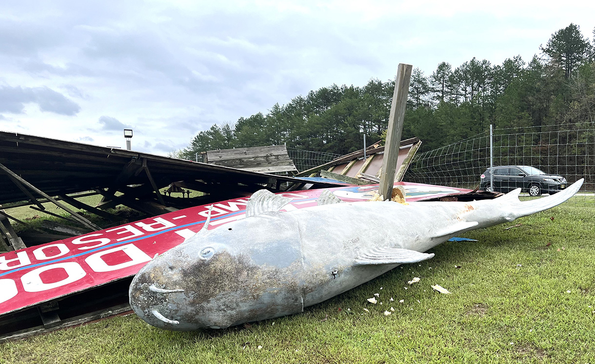
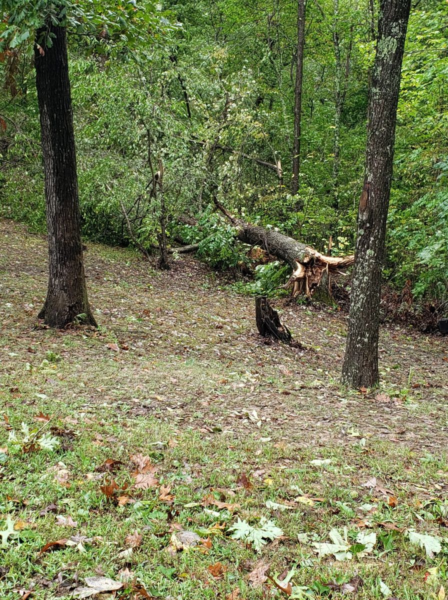
Uprooted tree in Oak Hill, WV Photo Courtesy of Becky Eaton |
Damaged signage along State Route 32 near Wellston, OH Photo Courtesy of Tom Stiffler |
 |
 |
|
Damage in Jackson, OH Telegram Photo by Jeremiah Shaver |
Snapped utility pole in Jackson, OH Telegram Photo by Jeremiah Shaver |
 |
 |
 |
|
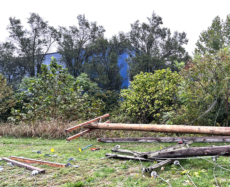
Snapped utility pole in Lavalette, WV Photo Courtesy of Bj Willis |
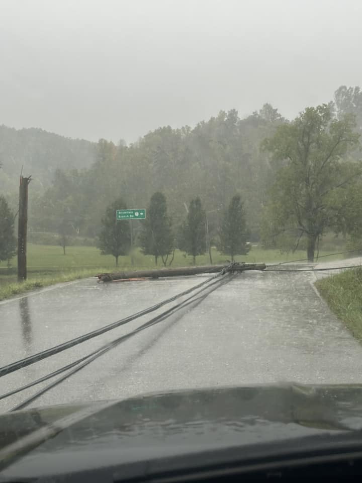
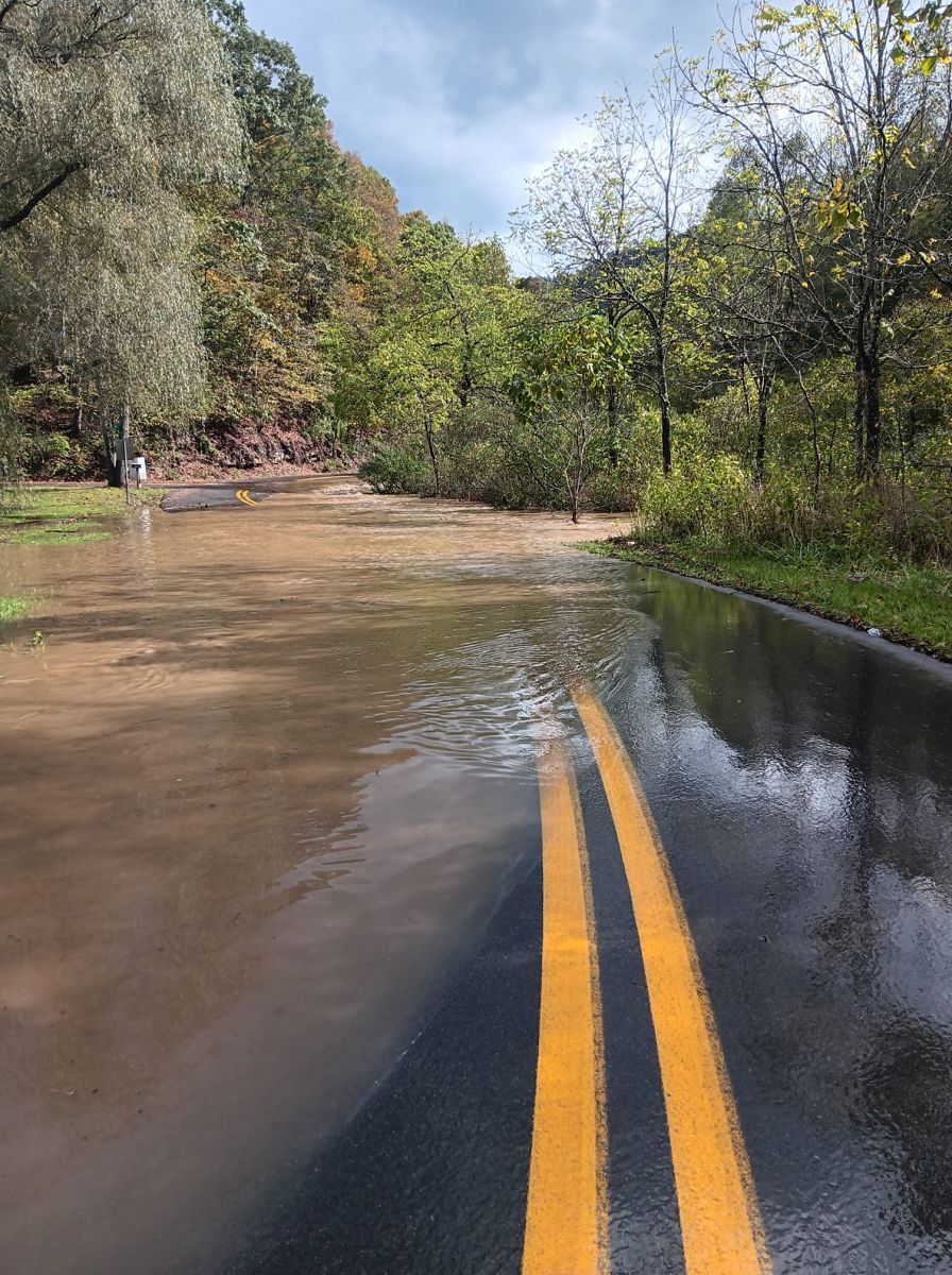
Flooded road in Anawalt, WV on 9-27 Photo Courtesy of Susan Junior |
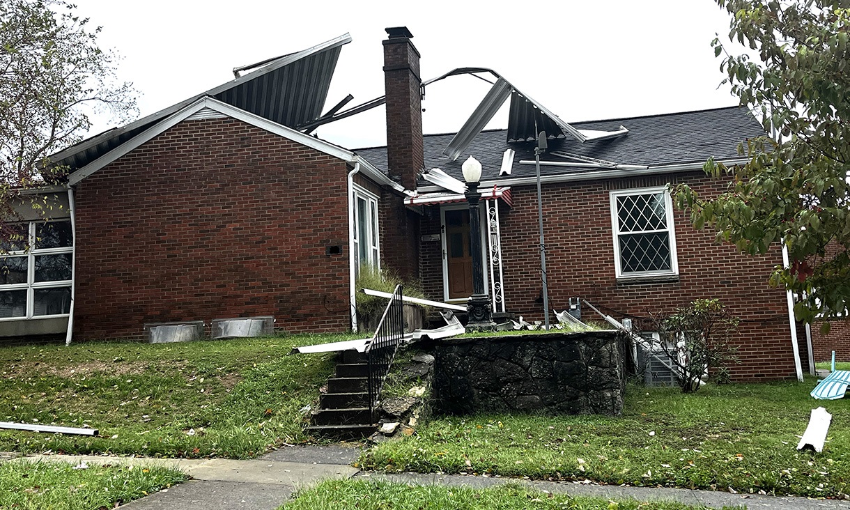
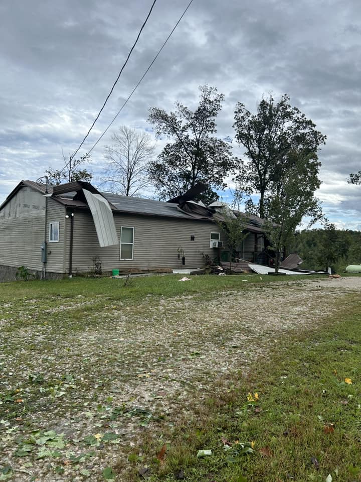
Damage to a home in Genoa, WV Photo Courtesy of Bj Willis |
 |
 |
 |
|
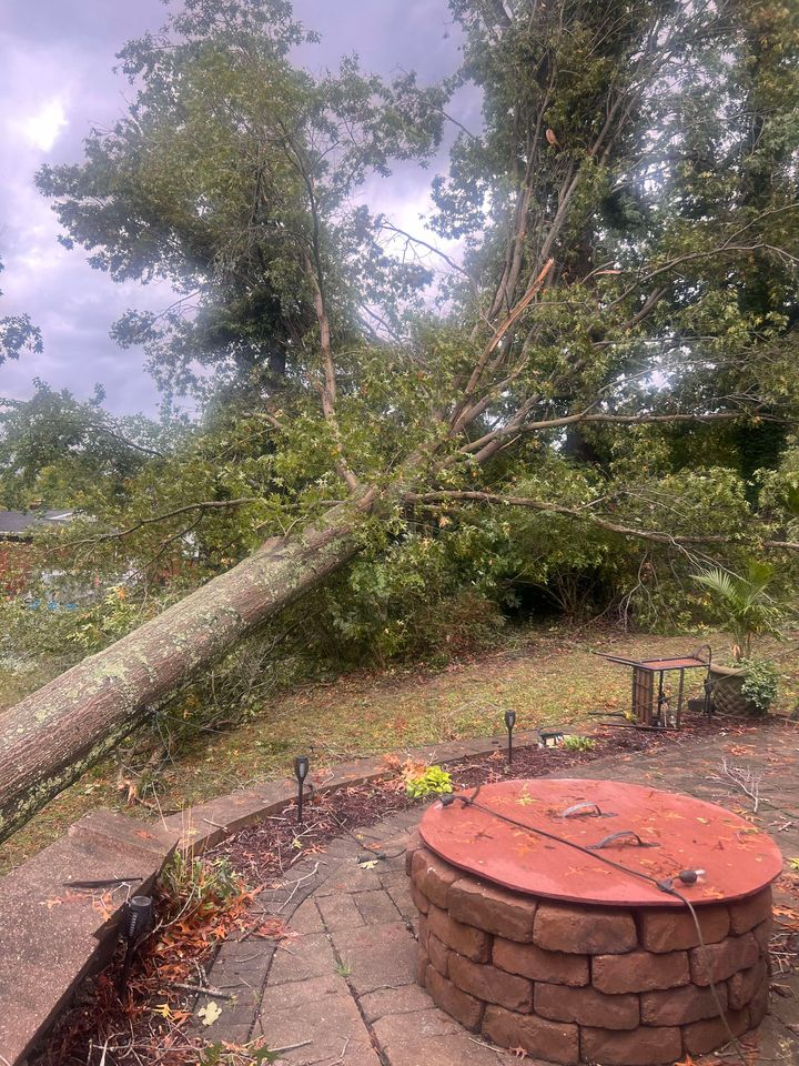
Large uprooted tree in Russell, KY Photo Courtesy of Shannon Beckett |
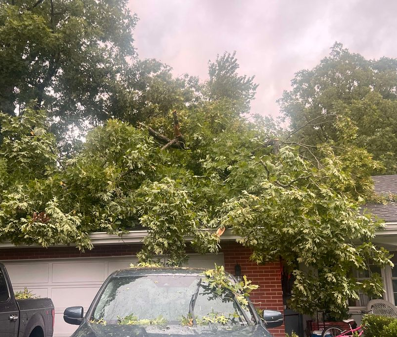
Tree damage on a home in Russell, KY Photo Courtesy of Shannon Beckett |
Downed tree in Gallia County (OH) Photo Courtesy of Bobbi Johnson |
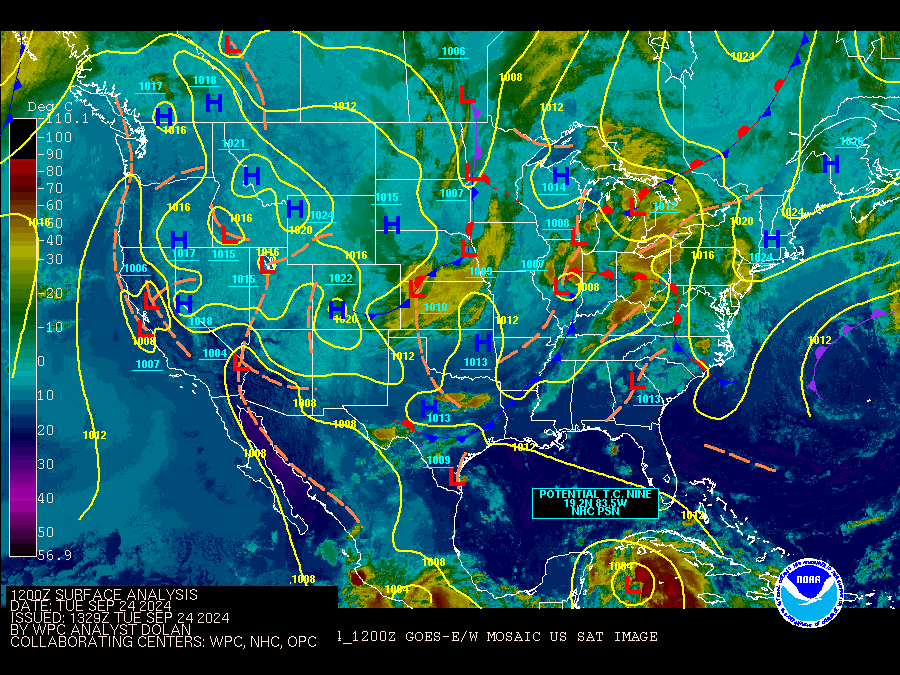
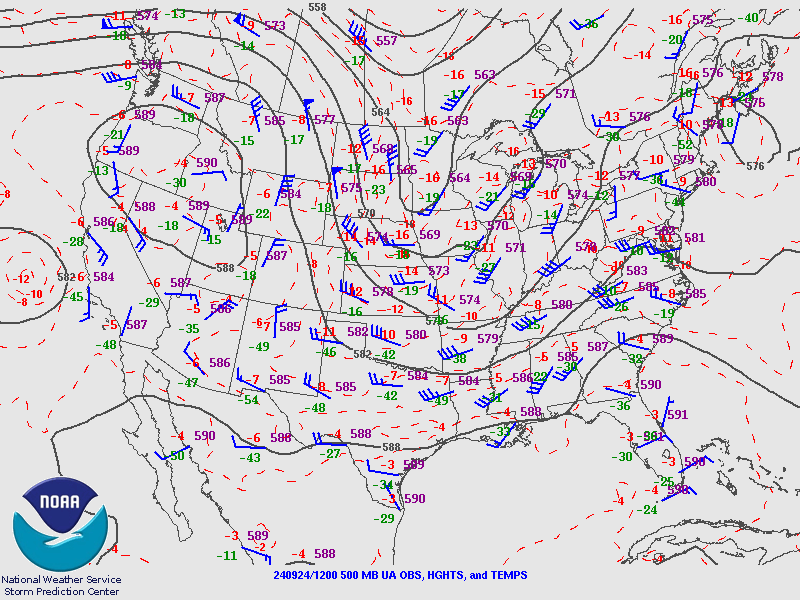
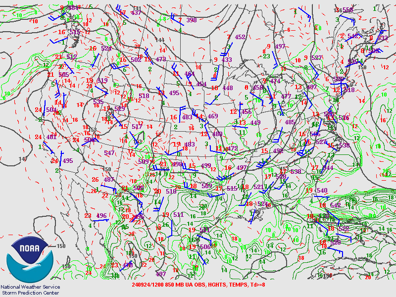
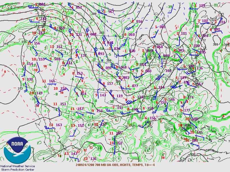
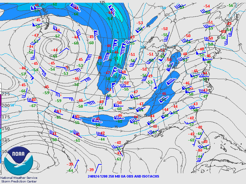
September 24th - October 2nd Surface and Upper Air Maps
Helene would be funneled/steered northward by a trough over the central Continental United States (CONUS) and ridge off the southeast CONUS, eventually pivoting around an increasingly cutoff upper-level low that was located southwest of our region. The remnants of Helene would continue to interact with the aforementioned cutoff upper low for several days just southwest of the NWS Charleston forecast area, with an approaching upper trough and associated cold front finally helping to shift the aforementioned features across and east of the area on late September 30th through October 1st. The loops below run from 8 AM September 24th until 8 AM October 2nd. The 850/700/500/250 millibar (mb) analysis loops are at 12-hr intervals and are time synchronized. The surface analysis loop is generally at 6-hr intervals, but has shorter intervals for the time frame that corresponded to peak impacts for the NWS Charleston forecast area from Helene. All loops are in Coordinated Universal Time (UTC or Z), which is a 4-hr offset from EDT (for example - 1200Z is equivalent to 8 AM EDT).
|
|
 |
|
Infrared Satellite Loop w/ Surface Analysis Overlay Loop Credit: Weather Prediction Center |
500 mb Analysis Loop Loop Credit: Storm Prediction Center |
 |
 |
 |
|
850 mb Analysis Loop Loop Credit: Storm Prediction Center |
700 mb Analysis Loop Loop Credit: Storm Prediction Center |
250 mb Analysis Loop Loop Credit: Storm Prediction Center |
 |
Media use of NWS Web News Stories is encouraged! Please acknowledge the NWS as the source of any news information accessed from this site. |
|