|
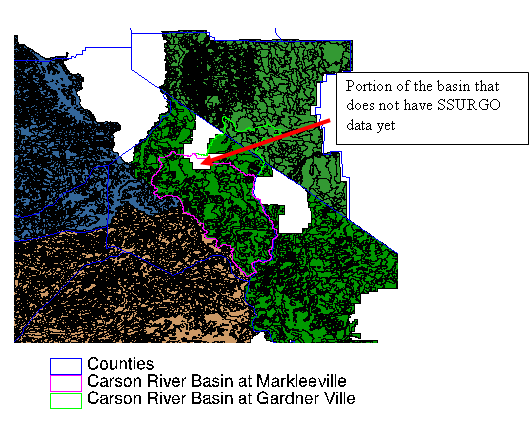
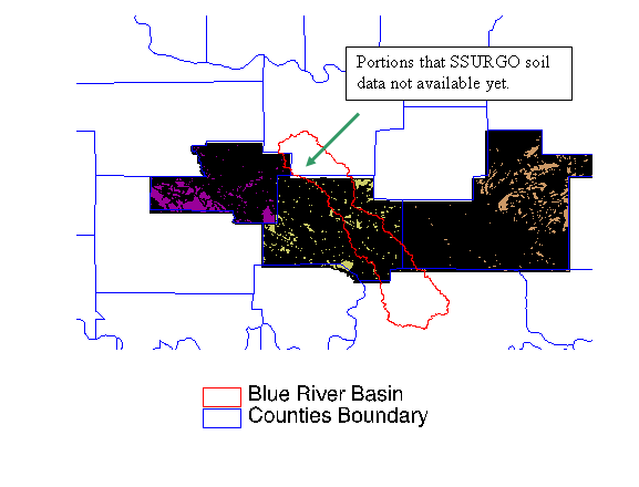
We do not provide SSURGO data on this page. This page does provide a general description, links to access the data from the USDA, a list of soil survey areas overlapping with the DMIP basins, and maps showing the size, coverage and location of soil survey areas relative to DMIP basins. General Description SSURGO databases are archived and distributed by the Natural Resources Conservation Service (NRCS) - National Cartography and Geospatial Center (NCGC). They are available for selected counties and areas throughout the United States and its territories. Completion of the SSURGO data digitizing is scheduled for 2008. For this reason, not all survey areas are available in digital format at this time. The Soil Data Mart lists the survey areas available. Based on the archived status map, not all data are available for all DMIP 2 basins as of 9/6/2006. Data for some of soil survey areas that cover the Blue River basin are not archived yet. The data for a portion of Carson River basin are also not available yet. The data can be downloaded from Geospatial Data Gateway, one soil survey area at a time. While the Gateway provides file downloads, a customer can also order SSURGO data on CD-ROM or DVD. A SSURGO dataset consists of map data, attribute data, and metadata. SSURGO map data are available in ArcView® shape file, ArcInfo coverage®, and ArcInfo interchange® file formats. The coordinate systems are Geographic, Universal Transverse Mercator (UTM), and State Plane. Attribute data are distributed in ASCII format and can be imported into a Microsoft Access® database. Metadata are in ASCII and XML format. The SSURGO data are typically available at a scale of at least 1:24,000. They are approximately about ten times the resolution of State Soil Geographic Database (STATSGO) data in which the soil polygons can be on the scale of 100 – 200 km2. The NOAA/NWS Hydrology Laboratory has used the data to derive parameters for the Sacramento Soil Moisture Accounting model (SAC-SMA) for lumped and distributed modeling. The detailed procedures to derive SAC-SMA parameters based on the SSURGO data can be found in Anderson et al. (2005). References Anderson, R.M., Koren, V.I., Reed, S.M., Using SSURGO Data to Improve Sacramento Model a priori Parameter Estimates, Journal of Hydrology, 320, 1-2, 103-116, 2006. Soil Survey Area Coverage Soil survey areas for Sierra-Nevada Basins of DMIP2:
Soil survey areas for Oklahoma test basins of DMIP2:
|
|
Main Link Categories: Home | HL | OHD | NWS |