Robert K. Hartman1, Andrew A. Rost1, Donald M. Anderson1
Operational Processing of Multi-Source Snow Data
ABSTRACT
Near real-time quantitative assessments of areal extent of snow cover and snow water equivalent
(SWE) provide valuable insight and information for water management, hydrologic forecasting,
and emergency preparedness entities throughout the United States and Canada. Since 1986, the
National Operational Hydrologic Remote Sensing Center (NOHRSC) of the National Weather
Service (NWS) has provided these data in rasters and alphanumeric tabulations generated using
satellite image processing, spatial interpolation, and GIS analysis.
Composite use of multi-source satellite (i.e., Advanced Very High Resolution Radiometer
(AVHRR) and Geostationary Operational Environmental Satellite (GOES)), point (i.e., manual
and telemetered observations), and line (i.e., airborne gamma radiation surveys) data is now
accomplished through the newly developed NOHRSC Operational Product Processing System
(OPPS). OPPS ingests and databases classified (i.e., snow, ground, cloud, and unknown) satellite
areal extent of snow cover rasters and all identified point and line samples of SWE and snow
depth. OPPS generative capabilities include user-prioritized composite raster generation and
multi-source gridded estimates of SWE and snow depth. OPPS spatial estimation processes for
SWE and snow depth combine point and line data with composited satellite areal extent of snow
cover rasters. OPPS can 1) output rasters in any of several common GIS formats, 2) create
displayable images with user-defined vector overlays, and 3) integrate raster data within basin
boundaries to produce alphanumeric data products. OPPS products can be stored and distributed
using the NOHRSC World Wide Web home page, FTP'd over Internet to interested cooperators,
and sent to NWS offices over AFOS (Automation of Field Offices and Services).
INTRODUCTION
Near real-time quantitative assessments of areal extent of snow cover and gridded snow water
equivalent (SWE) provide valuable insight and information for water management, hydrologic
forecasting, and emergency preparedness agencies throughout the United States and Canada.
Since 1986, the National Operational Hydrologic Remote Sensing Center (NOHRSC) of the
National Weather Service (NWS) Office of Hydrology (OH) has provided these data in rasters
and alphanumeric tabulations generated using satellite image processing, spatial interpolation and
GIS analysis. Until recently, each of these processes were performed independently. They are
now largely integrated in the newly developed NOHRSC Operational Product Processing System
(OPPS).
Estimates of the extent, depth, and water equivalent of snow are developed at the NOHRSC from
a variety of dynamic data sources including:
- Satellite imagery acquired daily at a variety of resolutions from a variety of sensors (i.e.,
Advanced Very High Resolution Radiometer (AVHRR) and Geostationary Operational
Environmental Satellite (GOES));
- Airborne gamma radiation survey snow water equivalent data sets; and
- Station observations reporting point data on snow water equivalent, snow depth, air
temperature, etc. (i.e., SNOTEL, snow course, aerial markers, etc.).
Analyses of these data are supported by static data sets including hydrologic basin boundaries at
various scales, thematic land use and land cover grids, and digital elevation models.
Prior to OPPS, each data type was analyzed by a separate data processing system. A given snow
estimation product may have employed a variety of input data sources and therefore more than
one process was required. For instance, to produce a tabulation of mean SWE by elevation band,
the following processes were executed:
- Acquire and analyze satellite imagery to produce an areal extent of snow cover map;
- Spatially interpolate SWE station observations;
- Mask the SWE spatial interpolation with the snow cover map to ensure that SWE is
estimated only where snow is observed;
- Stratify interpolated SWE by elevation bands; and
- Average SWE within each elevation band for individual hydrologic basins.
While each individual process was highly automated, the integration of intermediate outputs into
the final products was both labor intensive and procedurally inefficient.
OPPS DESIGN
OPPS was developed to meet the following design objectives:
- To streamline, to the greatest extent possible, the production of snow estimation products
in an operational environment;
- To integrate, in an automated and objective manner, a wide variety of input data sources
used to produce snow estimation products;
- To develop and employ state-of-the-art spatial data processing algorithms tailored to the
task of producing snow estimation products from integrated input data sources; and
- To automate the dissemination of generated products.
A major objective in the design of OPPS was to automate data integration. Primarily through the
use of spatial interpolation techniques and polygon membership modeling, OPPS is capable of
integrating raster data with point, line and areal vector data. The integration of variable-resolution raster data is supported by run time data sub- and super-sampling functions allowing
OPPS to define a range of output product resolutions without regard to the resolution of the input
data.
The spatial integration of raster and vector data is supported by automated procedures which
exploit the temporal distribution of the input data. Many OPPS processes are designed to
evaluate data within windows of opportunity centered on a target date. Because OPPS is
designed to address snow estimation on a continental scale, there is a strong possibility that
suitable input data are not available for a given instant in time. For example, processes which
require satellite image derived maps of areal extent of snow cover are often hampered by cloud
cover. By integrating the cloud-free portions of multiple snow cover maps acquired during a
window of opportunity, OPPS can minimize the impact that cloud cover has on the snow
estimation process. Similar mechanisms were designed into OPPS for the treatment of each input
data source.
OPPS consists of a series synchronized programs communicating with one another through an
INFORMIX database server and system calls (Figure 1). The OPPS programs fall into three
classes: Database, Analysis, and Product Development. The OPPS programs are supported by
the OPPS database consisting of static and dynamic tabular and graphic data. The dynamic
portion of the OPPS database is constantly updated by a wide variety of inputs. The remainder of
this paper describes, in some detail, the OPPS components and their relationships in the
production of OPPS outputs.
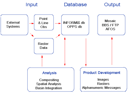
Figure 1. OPPS data/products/processing flow
OPPS INPUT
OPPS is designed to integrate data from a variety of sources, data-types, structures and formats.
OPPS can handle both raster and vector data types. Raster data can be variable in resolution.
Vector data may be either point, line, or area structures.
To minimize distortions associated with map-projected coordinates, OPPS requires that all of its
inputs be in geodetic (longitude and latitude or Earth) coordinate pairs. All calculations are
performed in the geodetic coordinate system. The World Geodetic System 1984 (WGS 84)
horizontal datum and the National Geodetic Vertical Datum of 1929 (NGVD 29) were selected
for OPPS on the basis of the availability of digital elevation model (DEM) data. Many of the
analysis programs in OPPS model orographic processes and, as such, are highly dependent upon
DEM data. The highest quality of DEM Data available in national coverage are in the WGS 84
and NGVD 29 datums.
Point observations of snow water, snow depth, precipitation, and surface air temperature are
actively and passively acquired over Internet and are automatically ingested into the INFORMIX
database. As airborne survey data become available, they also are ingested into the INFORMIX
database.
Raster data inputs include areal extent of snow cover thematic rasters derived from the
reclassification of satellite images acquired from the GOES and the NOAA polar orbiter satellites
(AVHRR). Snow cover rasters are produced on a delay basis and are registered with the OPPS
database as they become available.
OPPS is capable of ingesting raster data in GRASS, ARC/INFO, and Global Imaging formats.
OPPS will be capable of ingesting raster data conforming to the SDTS raster profile in the near
future.
Point observation data are registered and stored as INFORMIX database records. OPPS is
capable of ingesting flat files into the INFORMIX database. All line and areal vector structures
are stored in OPPS as individual binary flat files whose headers are stored in the INFORMIX
database. Since many spatial data analysis systems (i.e., GIS) are capable of exporting flat files,
the OPPS approach for dealing with these types of data allows a great deal of flexibility.
OPPS DATABASE
OPPS maintains two databases:
- The OPPS database, a UNIX file system which organizes OPPS raster and vector files into
subdirectories; and
- The INFORMIX database which:
- Stores the characteristics, identity, and location of each OPPS-generated product;
- Stores the characteristics, identity, and location of each OPPS static data set (i.e.,
DEMS, basin boundaries, etc.); and
- Stores non-raster OPPS input data (i.e., station observations) and attributes.
In addition to storing information on products, the INFORMIX database is also used to control
the flow of integrated OPPS processes. Certain OPPS products are the consequence of multiple
data processing operations in which the output of one process is used as the input for a
subsequent process.
These multiple processing operations are internally defined and, as such, are transparent to the
user. When an OPPS product is requested, the request is registered in the INFORMIX database
as a unique record. The individual processes required to produce that product are automatically
queued by the OPPS subsystem. As subsequent processes are completed, their status is registered
in the INFORMIX database and the next process in the queue is initialized. Queued processing
continues until the final output product is generated.
OPPS ANALYSIS PROGRAMS
In its present state, OPPS consists of the following analysis programs:
Raster Compositing
This program generates composites from existing rasters in the OPPS database. It has two
functions:
- To produce a single raster mosaic of a larger area from multiple rasters of smaller
geographically distributed areas; and
- To produce a single raster composite from temporally-distributed rasters occupying the
same geographic area. As rasters are composited, unknown and cloudy pixels are
replaced by pixels of known value.
Both functions can operate simultaneously and there is full control of how multiple rasters are
integrated. Composite control is facilitated by prioritizing raster file attributes. Raster
compositing may be constrained by vector feature outlines.
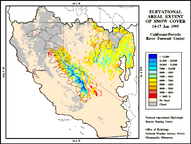
Areal Extent of Snow Cover by Elevation
This program produces a new raster in which the snow pixels in an areal extent of snow cover
raster are represented by DEM elevation values. The resultant raster depicts the horizontal and
elevational distribution of observed snow (Figure 2).
Inverse Distance Interpolation
This program accepts point and flight line observations as the x, y, and z sample data inputs into
the inverse distance weighted mean spatial interpolation algorithm. The user controls where,
geographically, sample points are to be gathered and how far the algorithm may search for sample
observations.
No-snow pixels in an areal extent of snow cover raster can be used as sample observations of zero
snow cover to constrain the interpolation. The snow cover raster may also be used to mask
interpolated pixels for which no snow was observed by the satellite.
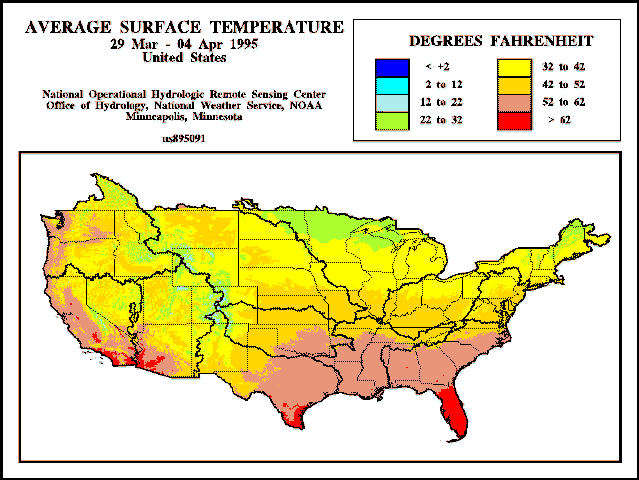
Temperature Interpolation
This program generates an inverse distance weighted mean interpolation of mean daily surface air
temperature. Surface temperature observations are lapsed to a common elevation of 4500 meters.
Temperatures interpolated at this elevation are lapsed back to the surface. The resultant product
reflects the orographic effect on surface air temperature (Figure 3).
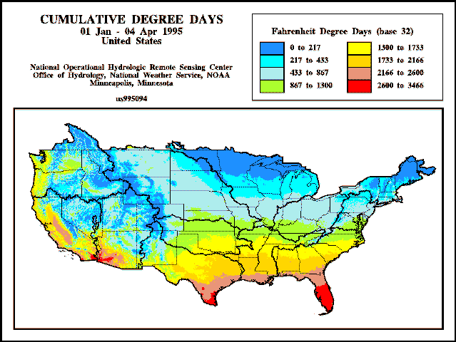
Degree Day Accumulation
This program sums, for each grid cell, the daily positive differences between interpolated surface
air temperature and a specified base temperature. The output is useful for calculating the number
of snowmelt degree days beyond a given date. The area calculated may be constrained by vector
feature outlines (Figure 4).
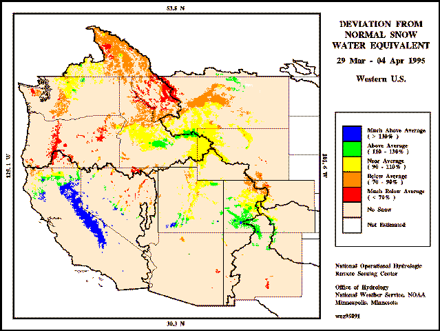
Orographic Interpolation
This program estimates SWE or snow depth in areas in which there are orographic dependencies
(Figure 5).
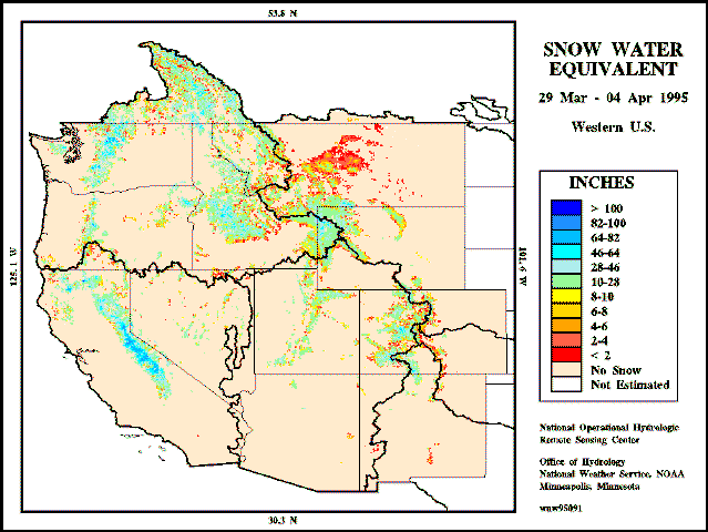
For a given cell:
- The nearest snow line elevation is computed on an areal extent of snow cover image; and
- Ground-based SWE or snow depth point observations within a threshold distance are
identified in the OPPS
A linear SWE (or snow depth) by elevation (orographic) relationship is established between the
observed snow line and the mean point observation. A first approximation of SWE or snow depth
for a given cell is calculated by applying the cell's elevation in this orographic relationship. The
details of orographic interpolation are presented in an accompanying paper ("Spatial Distribution
of Snow Water Equivalent Observations in Mountainous Terrain"). The SWE rasters generated
by this program can be compared against historic data to determine deviations from normal SWE
(Figure 6).
Basin Analysis
This program will, on a basin-by-basin analysis, compute mean areal snow values (i.e., SWE,
snow depth, etc.) by predefined elevation bands. The resulting tabulations are stored in the
INFORMIX database as time-stamped records. As basins are examined throughout the snow
season, additional basin analysis records are related to each basin, yielding a time series of basin
snow data.
OPPS PRODUCT DEVELOPMENT
OPPS generates a variety of gridded products derived from raster and vector inputs using
processes designed specifically for snow distribution estimation. Basin-integrated values can be
summarized into coded Standard Hydrometeorological Exchange Format (SHEF) alphanumeric
products specifically tailored to a specific user's needs.
All of the gridded products generated by OPPS reside in the OPPS database in a binary format
designed to accommodate the needs of the NOHRSC. OPPS is capable of exporting these rasters
into a variety of formats including GRASS, ARC/INFO ASCII grids, and Global Imaging
(essentially a flat binary raster with an 80 byte header).
While these formats respond to the needs of those interested in performing further data analysis,
some end users are interested primarily with images (pictures). To meet those needs, OPPS can
also generate GIF, TIFF, McPaint, and PCX formatted image files. A variety of vector overlay
features may be incorporated into these images, including states, basins, and observation points.
OPPS OUTPUT
The NOHRSC data are used operationally by the NWS, the Army Corps of Engineers and other
Federal, state, and private agencies when issuing spring flood outlooks, water supply outlooks,
river and flood forecasts, and reservoir inflow forecasts. In an effort to simplify the distribution of
products to regular data users, OPPS has incorporated a sophisticated data distribution subsystem
which automatically routes relevant and/or desired OPPS output products to agencies who have
registered their Internet FTP addresses with the NOHRSC. Users can also access OPPS
products via the NOHRSC World Wide Web Home Page (http://www.nohrsc.nws.gov).
Alphanumeric products are sent to NWS offices over AFOS (Automation of Field Offices and
Services).
CONCLUSION
The NOHRSC is an operational center within the National Weather Service Office of Hydrology
which has, as one of its major responsibilities, the task of mapping snow cover characteristics for
all of the United States and portions of Canada. While the NOHRSC has always employed state-of-the-art techniques in accomplishing this task, OPPS, for the first time, allows the snow
hydrologist access to the full value of the available input data.
Through the integration of a broad variety of input data sources, the exploitation of temporal
processes, and the design and implementation of data management and analysis programs tailored
to snow distribution analysis, OPPS is capable of providing and distributing near real time analysis
of the highest quality currently available.
1National Operational Hydrologic Remote Sensing Center
Office of Hydrology, National Weather Service
1735 Lake Drive West
Chanhassen, Minnesota 55317-8582
Telephone (612)361-6610, Facsimile (612)361-6634
email: {rhartman, arost, danderson}@nohrsc.nws.gov
www: http://www.nohrsc.nws.gov

