
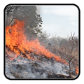
Wildfires and poor air quality continue for the Pacific Northwest, Rockies and extended into the Plains. Severe thunderstorms possible for the northern Plains and upper Midwest on Monday along a frontal boundary. Another boundary will focus showers and thunderstorms for the eastern seaboard with localized heavy rainfall possible. For Alaska, a strong Bering Sea storm will bring winds and rainfall. Read More >
Last Map Update: Sun, Aug 2, 2026 at 5:46:52 pm CDT


|
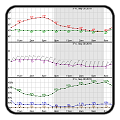
Local Weather History For August 2nd...
|
|
It was a very warm start to August in 2012 for Wichita Falls, Texas
and much of the region. From July 31 through August 2, record high temperatures were broken each day at Wichita Falls. The record numbers ranged from 110 to 112 degrees. |
|
Text Product Selector (Selected product opens in current window)
|
|
 |
 |
 |
 |
 |
 |
| Observations | Discussion | Air Quality | Hydrology | FAQ | Social Media |
 |
 |
 |
 |
 |
 |
| Storm Reports | Gridded Forecast | Aviation | Climate | Storm Data | Weather Radio |
 |
 |
 |
 |
 |
 |
| Satellite | Hourly Forecast | Fire Weather | Past Events | StormReady | Storm Spotters |


 Local Radar
 Weather Map
 Drought Conditions