National Weather Service United States Department of Commerce

Dangerous Fire Weather Conditions in Southern California; Snow in the Rockies

A strong Santa Ana wind event will bring widespread Extremely Critical fire weather conditions to many areas of Los Angeles and Ventura counties into Thursday. Heavy snow is impacting the central to southern Rockies and nearby High Plains. Hurricane Rafael continues to bring tropical storm conditions to the Florida Keys. Read More >

Click a location below for detailed forecast.

Last Map Update: Thu, Nov 7, 2024 at 2:32:22 am CST
Numerous rounds of showers will lead to widespread 1-4 inches of rainfall across the whole area. Heavy rainfall may lead to flash flooding.
Rain chances return to the area Thursday and continue through the early parts of the weekend.
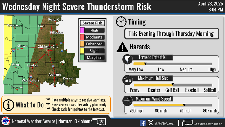
A few strong to marginally severe thunderstorms are possible Thursday evening into early Friday morning across north Texas. Large hail is the main concern with the strongest thunderstorms.

 Current Weather Observations...
Location Time
(CST)
Weather Vsby.
(SM)
Temp.
(ºF)
Dewpt.
(ºF)
Hum.
(%)
Wind
(mph)
Wind Chill / Heat Index
(ºF)
Pres.
(in)
Oklahoma City, OK01:52Clear10514682NNE 9-30.14
Norman, OK01:55Clear10494586N 7-30.12
Stillwater, OK01:53Clear10504479NNE 9-30.16
Lawton, OK01:53Clear10544880NNE 10-30.09
Wichita Falls, TX01:52Clear10514785NE 6-30.07
Ponca City, OK01:53Clear10504376ENE 10-30.18
Enid, OK01:55Clear10504581NNE 10-30.13
Alva, OK01:55Mostly Clear10464493ENE 941 [WC]30.17
Woodward, OK01:55Mostly Cloudy10464287E 841 [WC]30.18
Gage, OK01:53Mostly Clear10434192CALM-30.15
Watonga, OK01:55Clear10484690NE 944 [WC]30.18
Clinton, OK01:53Clear10494586ENE 7-30.13
Weatherford, OK01:55Clear10494586E 6-30.14
Altus, OK00:15Mostly Cloudy10554466NE 8-30.08
Frederick, OK01:53Clear10544777ENE 13-30.05
Ardmore, OK01:55Overcast8514887N 10-30.09
Ada, OK01:55Mostly Cloudy10515093N 6-30.11

Local Weather History For November 7th...
Several supercell thunderstorms developed over southwest Oklahoma and
northern Texas during the afternoon hours and moved northeast on this
day in 2011. One particularly nasty supercell storm developed over
Wilbarger county in western north Texas. This storm moved northeast
into Tillman county Oklahoma, eventually producing at least eight
tornadoes over a five county area. Two of the tornadoes moved near
two Oklahoma Mesonet observation sites, both taking a direct hit. The
Mesonet site near Tipton measured 86.4 mph before it was destroyed by
debris. The Mesonet site near Fort Cobb measured 91.4 mph before it
was destroyed. Although there was extensive damage from tornadoes,
hail, and flash flooding across parts of southern Oklahoma, no
injuries were reported.

Text Product Selector (Selected product opens in current window)
Weather Observations Area Forecast Discussion Air Quality Forecasts Hydrology Information Frequently Asked Questions Social Media
Observations Discussion Air Quality Hydrology FAQ Social Media
 
Submit a Storm Report Graphical Weather Forecasts Aviation Weather Forecasts Climate Data Storm Data Weather Radio Information
Storm Reports Gridded Forecast Aviation Climate Storm Data Weather Radio  
 
Satellite Information Hourly Weather Forecast Fire Weather Information Past Weather Events StormReady Skywarn/Storm Spotters
Satellite Hourly Forecast Fire Weather Past Events StormReady Storm Spotters