
Strong to severe thunderstorms will continue tonight across portions of the Ohio Valley into the Mid-Atlantic. Heavy rains may bring an isolated flash flooding threat over the central Appalachians, particularly in West Virginia. Moderate to heavy snow will continue over portions of northern Minnesota and the Upper Peninsula of Michigan through Tuesday morning. Read More >
|
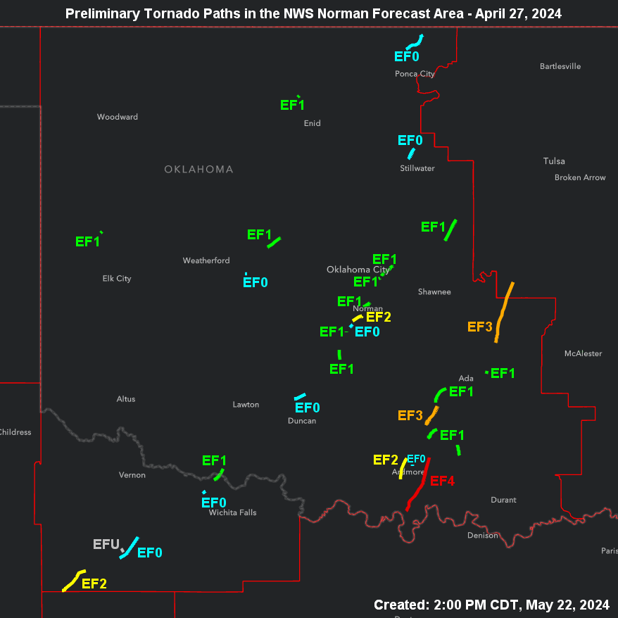
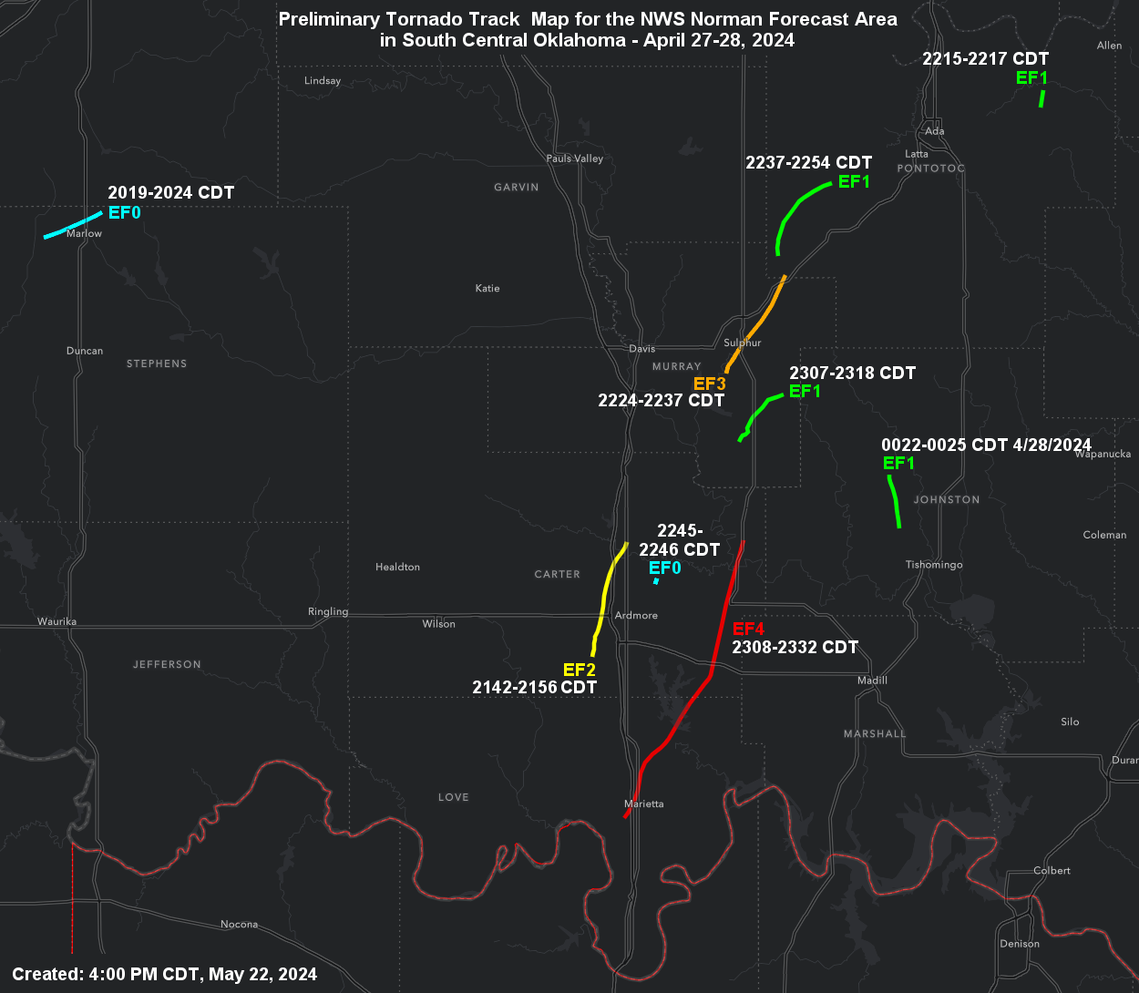
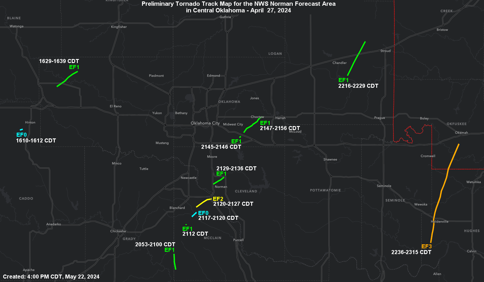
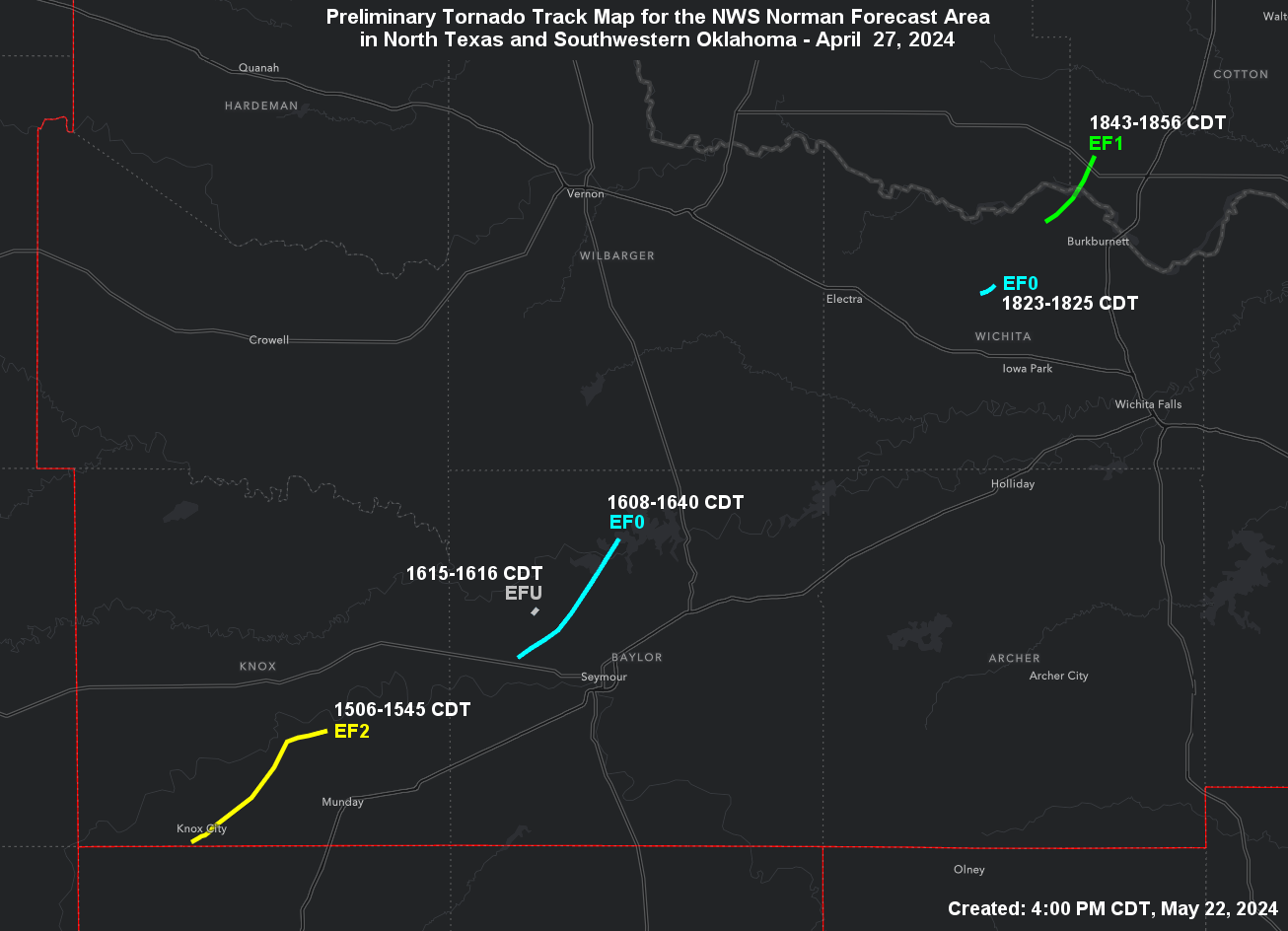
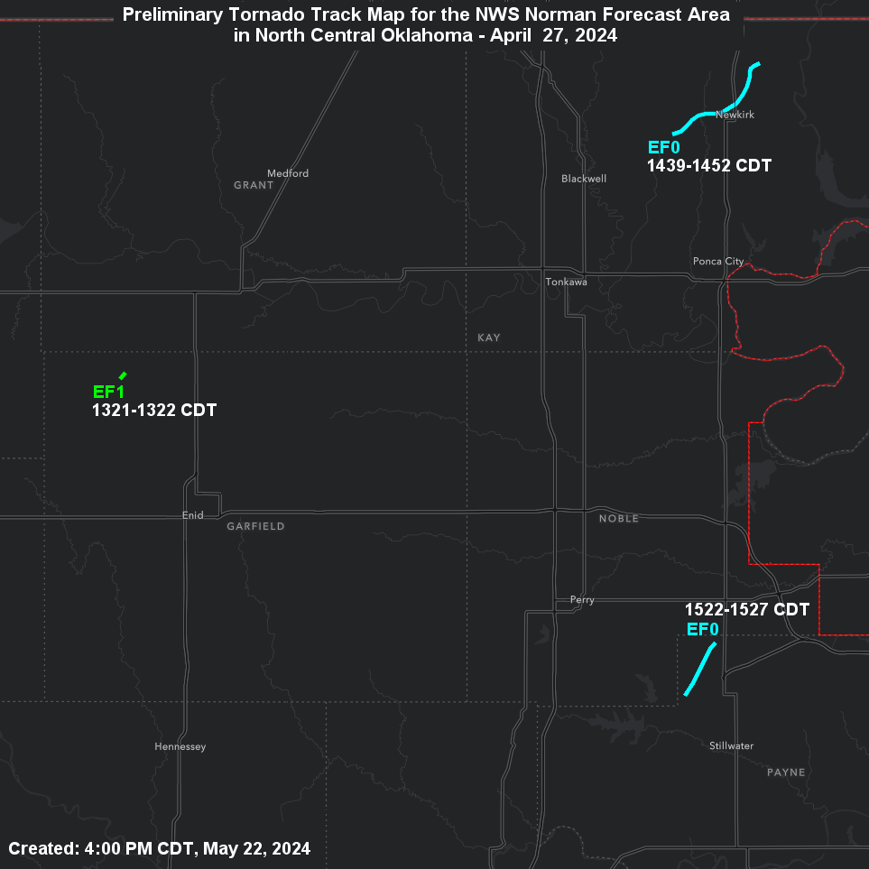
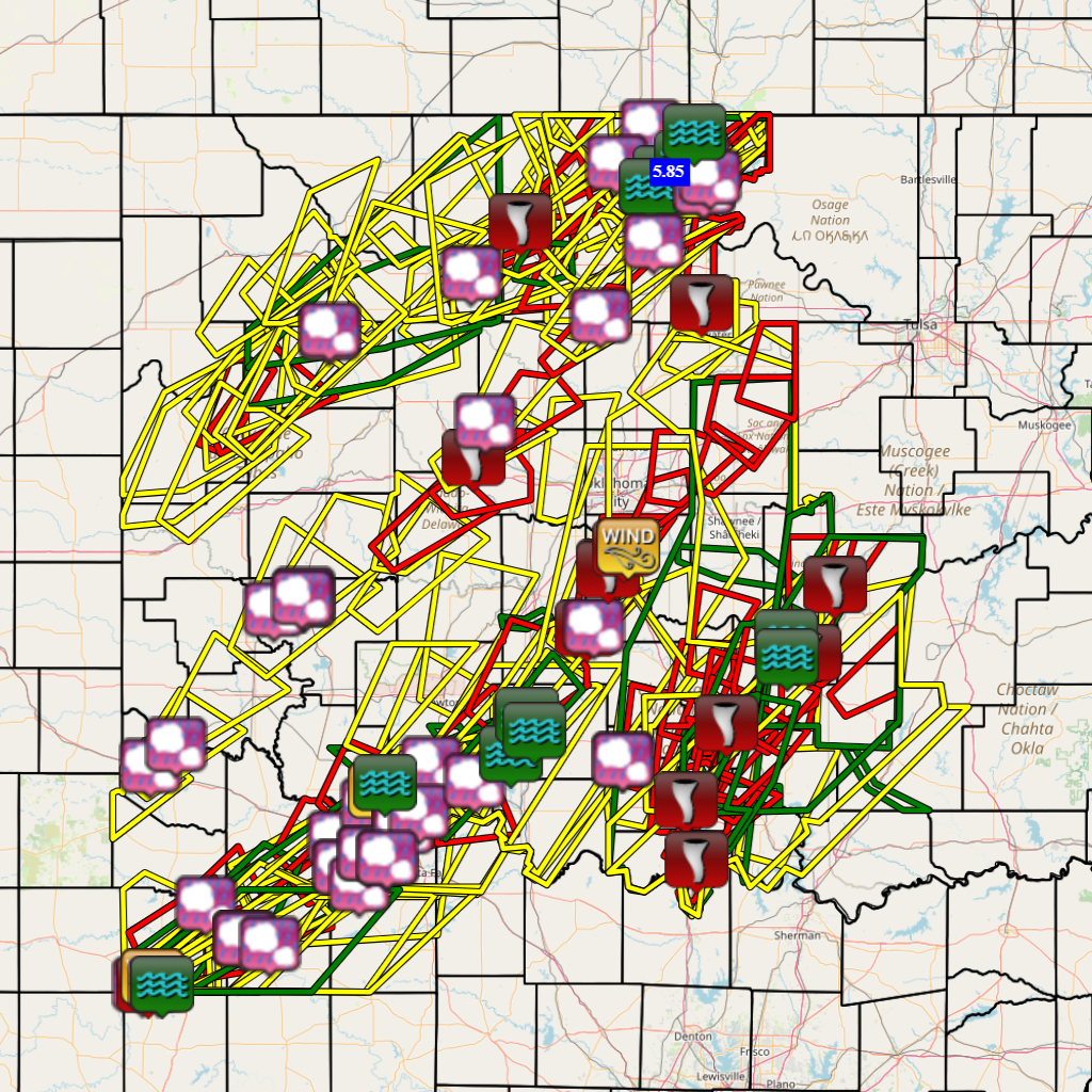
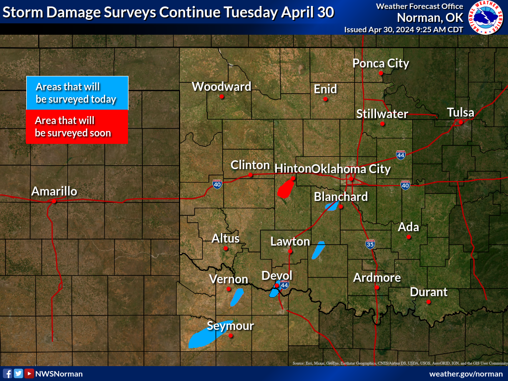
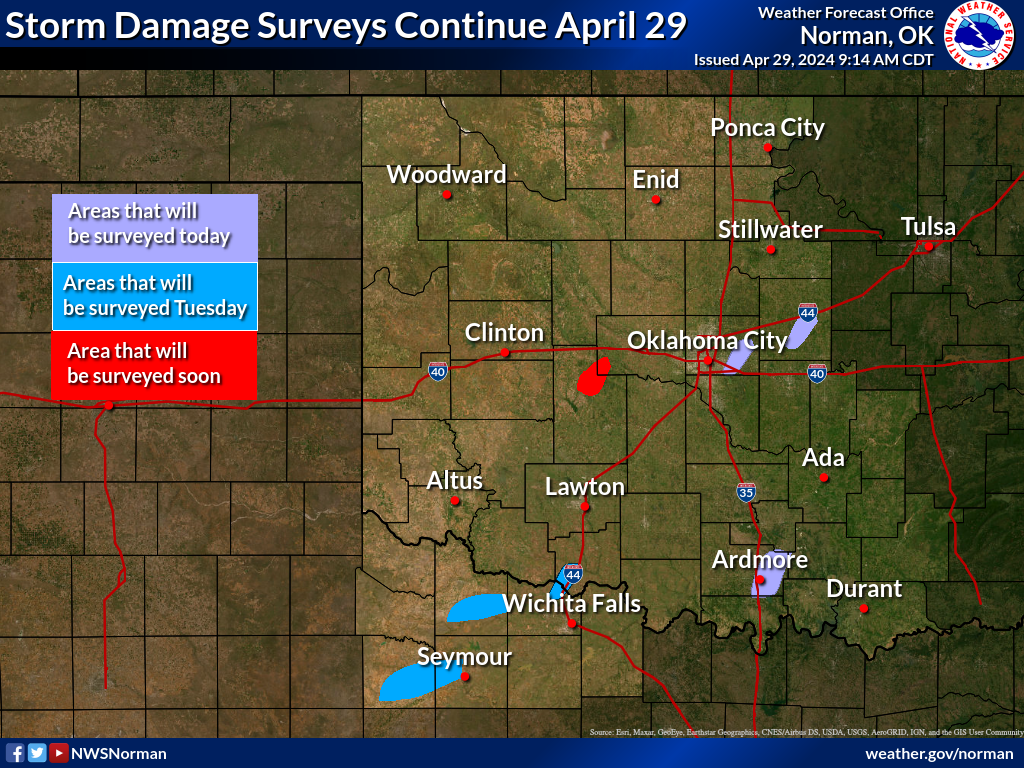
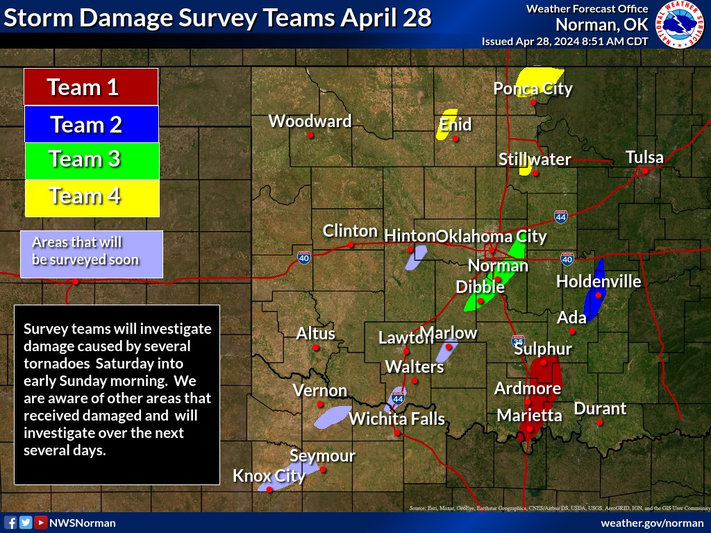
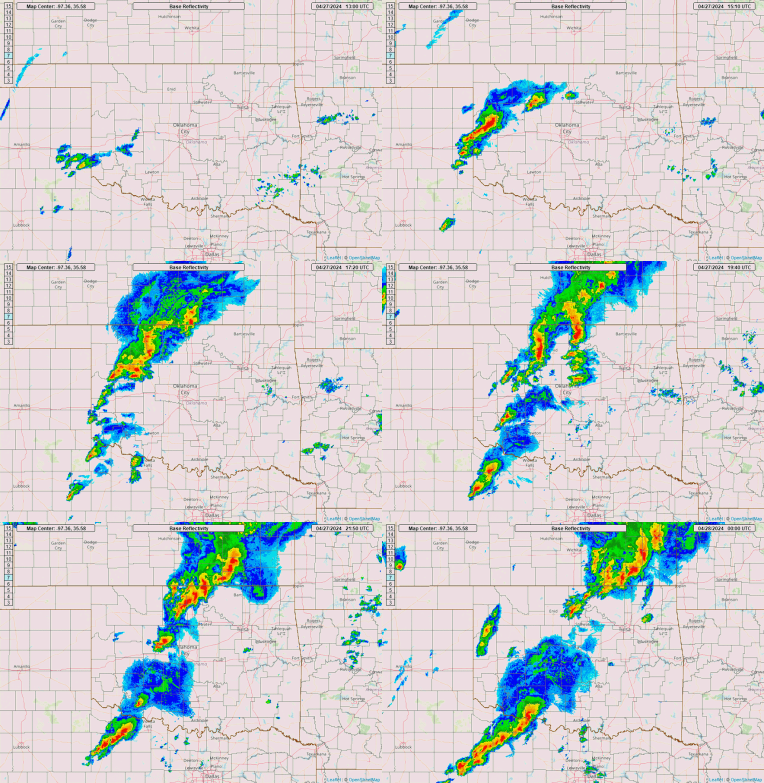
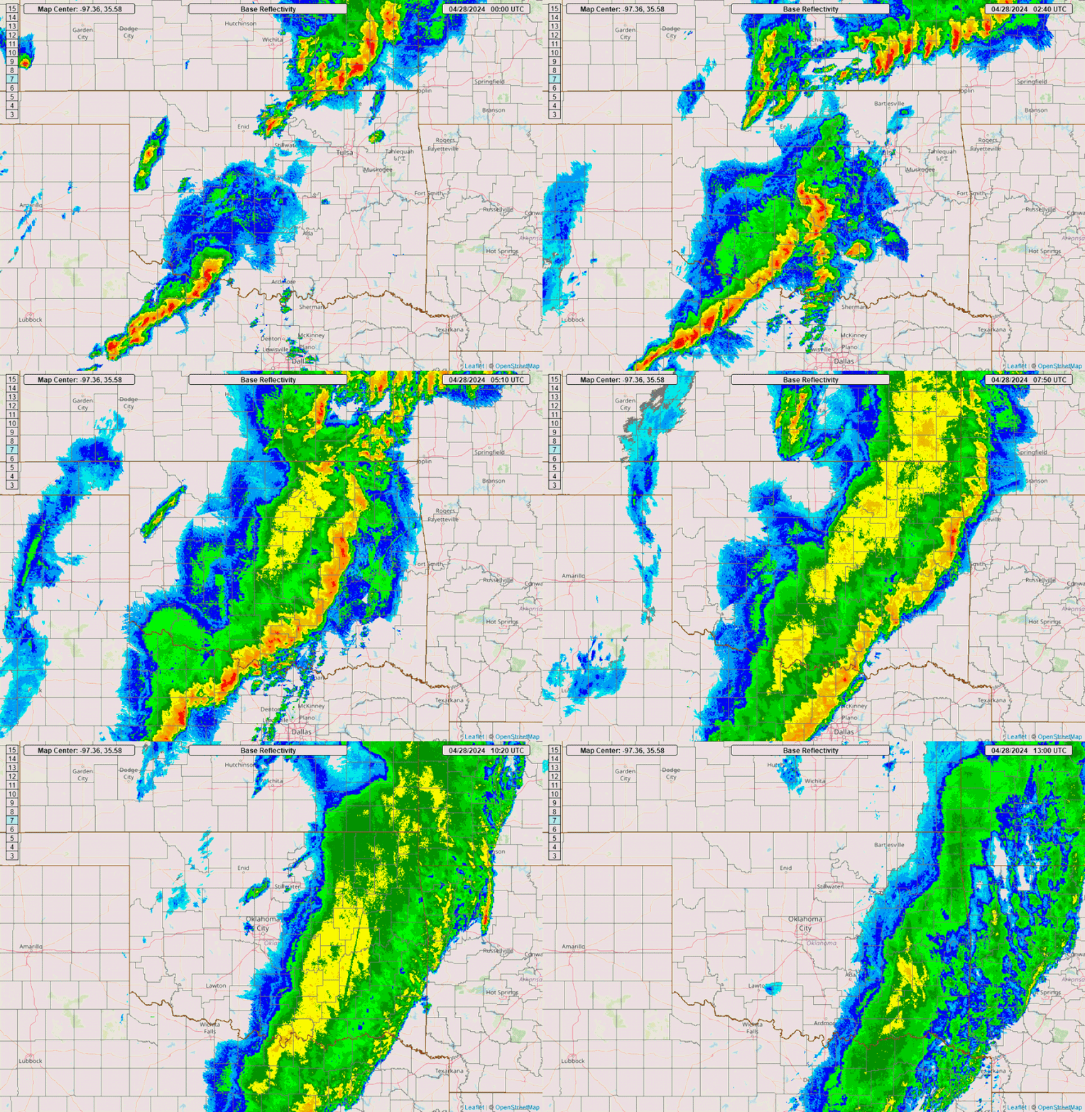
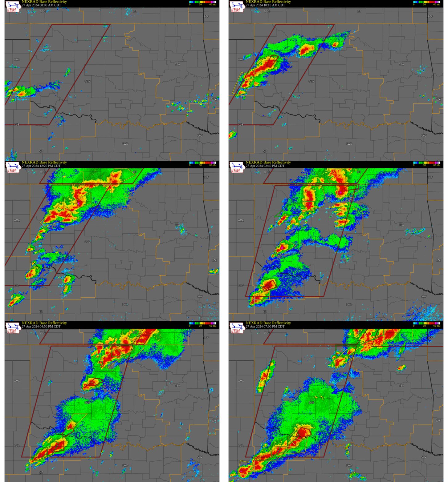
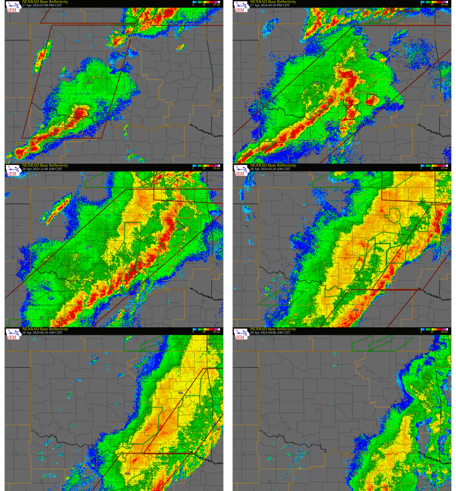
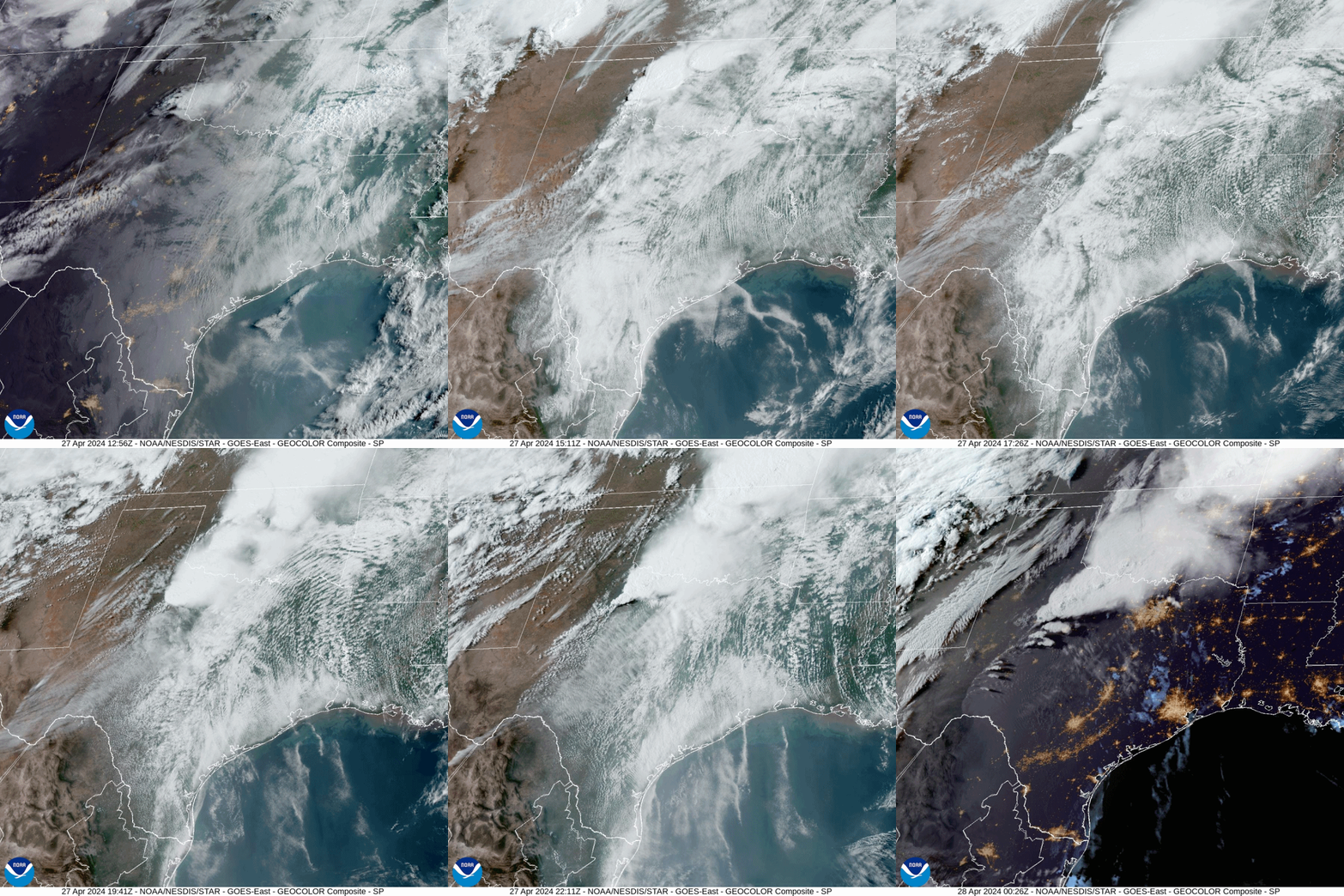
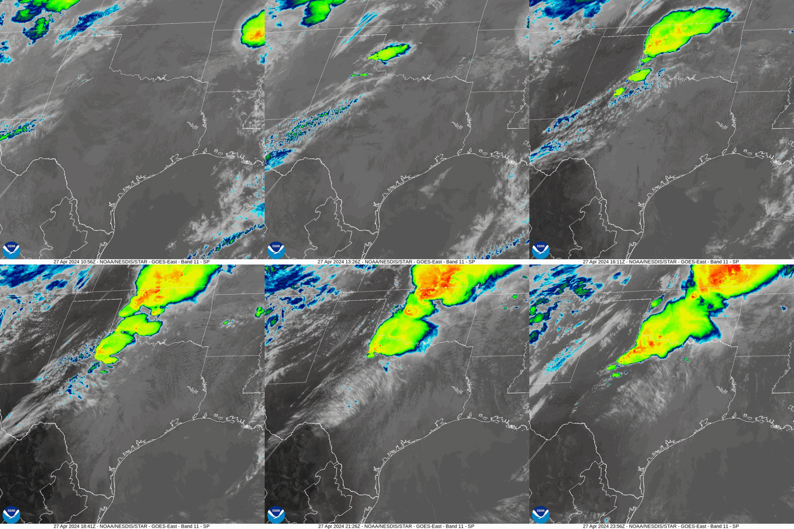
A slow-moving, but potent late April storm system produced an outbreak of at least 32 tornadoes and other severe weather from the late morning through the evening hours of April 27, 2024, and the early morning hours of April 28, 2024 in the NWS Norman forecast area. Excessive rainfall of 4 to 8.75 inches produced severe flash flooding and river flooding across parts of Oklahoma and western north Texas. Hail up to 3 inches in diameter and severe wind gusts up to 60 mph were observed during this event. The NWS Norman staff and the NWS Tulsa staff have confirmed that at least 39 tornadoes occurred during the April 27-28, 2024 tornado outbreak. A total of 35 tornadoes occurred in Oklahoma, with 28 tornadoes documented in the NWS Norman forecast area and 8 tornadoes documented in the NWS Tulsa area. The tornado that occurred near Holdenville crossed from Hughes County into the NWS Tulsa forecast area in Okfuskee County. Surveys on April 30, 2024 confirmed that 5 tornadoes occurred in western north Texas including Baylor, Knox, and Wichita counties. One of the tornadoes began in Wichita County and crossed the TX/OK state line into Cotton County, OK. Teams from NWS Norman conducted damage path surveys in Oklahoma on April 28-30, 2024. More information will added to this web page as it becomes available. A link to a GIS file that contains tornado damage paths and damage survey areas is available below. |
|
| Year | Total |
| 2024 | 56 |
| 2012 | 54 |
| 2011 | 51 |
| 1957 | 40 |
| 2016 | 27 |
| Year | Total |
| 2024 | 35 |
| 1983 | 7 |
| 1966 | 3 |
| 2021 | 2 |
| 2014* | 2 |
NOUS44 KOUN 011719
PNSOUN
OKZ004>048-050>052-TXZ083>090-020530-

Public Information Statement
National Weather Service Norman OK
1219 PM CDT Wed May 1 2024

...NWS Damage Survey for 4/27/24 and 4/28/24 Tornado Event Update #1...

.Update...Added two tornadoes (near Marlow OK and near Drake OK), added
details on four previously confirmed tornadoes (near Knox City TX, near
Hinton OK, near Seymour TX, Devol OK), and modified path information
for four tornadoes (west of Calumet OK, Midwest City/Choctaw OK, Sulphur
OK, Spaulding-Holdenville OK)

.Hillsdale...

Rating:                 EF1
Estimated Peak Wind:    85 to 90 mph
Path Length /statute/:  0.7 miles
Path Width /maximum/:   To be determined
Fatalities:             0
Injuries:               0

Start Date:             04/27/2024
Start Time:             01:21 PM CDT
Start Location:         Hillsdale / Garfield County / OK
Start Lat/Lon:          36.56 / -97.99

End Date:               04/27/2024
End Time:               01:22 PM CDT
End Location:           1 ENE Hillsdale / Garfield County / OK
End Lat/Lon:            36.57 / -97.98

Survey Summary:
Emergency management reports tree and powerline damage at
Hillsdale.

.Near Newkirk...

Rating:                 EF0
Estimated Peak Wind:    70 to 75 mph
Path Length /statute/:  10 miles
Path Width /maximum/:   75 yards
Fatalities:             0
Injuries:               0

Start Date:             04/27/2024
Start Time:             02:39 PM CDT
Start Location:         2 SE Peckham / Kay County / OK
Start Lat/Lon:          36.86 / -97.15

End Date:               04/27/2024
End Time:               02:52 PM CDT
End Location:           4 SE Chilocco / Kay County / OK
End Lat/Lon:            36.94 / -97.02

Survey Summary:
Tornado began southwest of Newkirk, just north of Canteen Road
and North U street. The EF0 tornado began with tree and
outbuildings damaged before moving northeast. Around the
intersection of Waverly and Peckham, the tornado began moving
more to the east, before turning northward near the NW corner of
the city of Newkirk. The tornado then turned north again, after
passing US77 about a mile north of town. The tornado became
erratic, likely roping out and dissipating near Gate and Prentice
Road. Top winds were 70-75 mph towards the end of the tornado.

.Near Knox City TX...

Rating:                 EF2
Estimated Peak Wind:    110 to 115 mph
Path Length /statute/:  15 miles
Path Width /maximum/:   To be determined
Fatalities:             0
Injuries:               0

Start Date:             04/27/2024
Start Time:             03:06 PM CDT
Start Location:         1 SW Knox City / Knox County / TX
Start Lat/Lon:          33.40 / -99.83

End Date:               04/27/2024
End Time:               03:45 PM CDT
End Location:           Rhineland / Knox County / TX
End Lat/Lon:            33.53 / -99.64

Survey Summary:
A tornado developed southwest of Knox City and moved northeast
through the southeast part of Knox City causing damage to homes.
The tornado continued moving northeast snapping power poles
southwest of Rhineland and then dissipated near Rhineland with
additional tree damage.

.Northwest of Stillwater...

Rating:                 EF0
Estimated Peak Wind:    65 to 70 mph
Path Length /statute/:  5 miles
Path Width /maximum/:   30 yards
Fatalities:             0
Injuries:               0

Start Date:             04/27/2024
Start Time:             03:22 PM CDT
Start Location:         3 E Lake Mcmurtry / Payne County / OK
Start Lat/Lon:          36.17 / -97.13

End Date:               04/27/2024
End Time:               03:27 PM CDT
End Location:           5 SW Morrison / Payne County / OK
End Lat/Lon:            36.24 / -97.08

Survey Summary:
Most likely not a continuous path. First tree damage noted just
west of N Country Club Road and W Richmond Road. Last damage
noted near N Western Road and W Lone Chimney Road.

.West of Seymour to Lake Kemp...

Rating:                 EF0
Estimated Peak Wind:    70 to 75 mph
Path Length /statute/:  13 miles
Path Width /maximum/:   To be determined
Fatalities:             0
Injuries:               0

Start Date:             04/27/2024
Start Time:             04:08 PM CDT
Start Location:         2 E Red Springs / Baylor County / TX
Start Lat/Lon:          33.62 / -99.38

End Date:               04/27/2024
End Time:               04:40 PM CDT
End Location:           2 W Lake Kemp / Baylor County / TX
End Lat/Lon:            33.75 / -99.24

Survey Summary:
This tornado developed west of Seymour and moved northeast toward
Lake Kemp. The tornado primarily did tree damage northwest of
Seymour.

.Southwest of Hinton...

Rating:                 EF0
Estimated Peak Wind:    65 to 70 mph
Path Length /statute/:  0.8 miles
Path Width /maximum/:   To be determined
Fatalities:             0
Injuries:               0

Start Date:             04/27/2024
Start Time:             04:10 PM CDT
Start Location:         3 SW Hinton / Caddo County / OK
Start Lat/Lon:          35.45 / -98.39

End Date:               04/27/2024
End Time:               04:12 PM CDT
End Location:           3 SW Hinton / Caddo County / OK
End Lat/Lon:            35.44 / -98.40

Survey Summary:
This tornado southwest of Hinton was observed by storm chasers.
The specific location is estimated.

.Northwest of Calumet...

Rating:                 EF1
Estimated Peak Wind:    95 to 100 mph
Path Length /statute/:  7 miles
Path Width /maximum/:   50 yards
Fatalities:             0
Injuries:               0

Start Date:             04/27/2024
Start Time:             04:29 PM CDT
Start Location:         5 ESE Geary / Canadian County / OK
Start Lat/Lon:          35.61 / -98.23

End Date:               04/27/2024
End Time:               04:39 PM CDT
End Location:           5 N Calumet / Canadian County / OK
End Lat/Lon:            35.67 / -98.13

Survey Summary:
Trees and powerlines were damaged northwest of Calumet. Farther
northeast, there was minor damage to a home, and then power lines
downed and trailers overturned near 192nd Street Northwest and
Red Rock Road.

.Northwest of Iowa Park...

Rating:                 EF0
Estimated Peak Wind:    65 to 70 mph
Path Length /statute/:  1.5 miles
Path Width /maximum/:   To be determined
Fatalities:             0
Injuries:               0

Start Date:             04/27/2024
Start Time:             06:23 PM CDT
Start Location:         7 NNW Iowa Park / Wichita County / TX
Start Lat/Lon:          34.04 / -98.74

End Date:               04/27/2024
End Time:               06:25 PM CDT
End Location:           7 NNW Iowa Park / Wichita County / TX
End Lat/Lon:            34.05 / -98.71

Survey Summary:
A tornado was observed by a NSSL/Texas Tech research team northwest
of Iowa Park. No significant damage was observed in the area.

.Devol...

Rating:                 EF1
Estimated Peak Wind:    100 to 105 mph
Path Length /statute/:  7 miles
Path Width /maximum/:   To be determined
Fatalities:             0
Injuries:               0

Start Date:             04/27/2024
Start Time:             06:43 PM CDT
Start Location:         5 WNW Burkburnett / Wichita County / TX
Start Lat/Lon:          34.12 / -98.64

End Date:               04/27/2024
End Time:               06:56 PM CDT
End Location:           1 E Devol / Cotton County / OK
End Lat/Lon:            34.20 / -98.58

Survey Summary:
The tornado damaged power lines in northern Wichita County Texas
before moving northeast across the Red River into Cotton County
Oklahoma. Trees and powerlines were damaged in Oklahoma near and
south of Devol as well as homes receiving roof damage on the
southeast side of Devol.

.Marlow...

Rating:                 EF0
Estimated Peak Wind:    80 to 85 mph
Path Length /statute/:  5.5 miles
Path Width /maximum/:   To be determined
Fatalities:             0
Injuries:               0

Start Date:             04/27/2024
Start Time:             08:19 PM CDT
Start Location:         3 W Marlow / Stephens County / OK
Start Lat/Lon:          34.64 / -98.02

End Date:               04/27/2024
End Time:               08:24 PM CDT
End Location:           2 NE Marlow / Stephens County / OK
End Lat/Lon:            34.67 / -97.93

Survey Summary:
A tornado caused primarily tree damage from west of Marlow to the
north side of Marlow to just northeast of town.

.McClain-Grady County Line...

Rating:                 EF1
Estimated Peak Wind:    100 to 105 mph
Path Length /statute/:  4.3 miles
Path Width /maximum/:   225 yards
Fatalities:             0
Injuries:               0

Start Date:             04/27/2024
Start Time:             08:53 PM CDT
Start Location:         3 ENE Bradley / McClain County / OK
Start Lat/Lon:          34.90 / -97.66

End Date:               04/27/2024
End Time:               09:00 PM CDT
End Location:           5 SSW Dibble / McClain County / OK
End Lat/Lon:            34.96 / -97.67

Survey Summary:
A tornado developed south-southwest of Dibble and moved north-
northwest along the McClain-Grady County line. A number of trees
and at least one mobile home was damaged.

.North of Dibble...

Rating:                 EF1
Estimated Peak Wind:    95 to 100 mph
Path Length /statute/:  0.2 miles
Path Width /maximum/:   40 yards
Fatalities:             0
Injuries:               0

Start Date:             04/27/2024
Start Time:             09:12 PM CDT
Start Location:         3 NNE Dibble / McClain County / OK
Start Lat/Lon:          35.07 / -97.61

End Date:               04/27/2024
End Time:               09:12 PM CDT
End Location:           3 SW Cole / McClain County / OK
End Lat/Lon:            35.07 / -97.61

Survey Summary:
Tree damage was observed.

.Cole...

Rating:                 EF0
Estimated Peak Wind:    75 to 80 mph
Path Length /statute/:  1.7 miles
Path Width /maximum/:   75 yards
Fatalities:             0
Injuries:               0

Start Date:             04/27/2024
Start Time:             09:17 PM CDT
Start Location:         1 WNW Cole / McClain County / OK
Start Lat/Lon:          35.11 / -97.58

End Date:               04/27/2024
End Time:               09:20 PM CDT
End Location:           1 NNE Cole / McClain County / OK
End Lat/Lon:            35.12 / -97.56

Survey Summary:
This tornado produced tree damage just north of Cole.

.Goldsby...

Rating:                 EF2
Estimated Peak Wind:    120 to 125 mph
Path Length /statute/:  5 miles
Path Width /maximum/:   125 yards
Fatalities:             0
Injuries:               0

Start Date:             04/27/2024
Start Time:             09:20 PM CDT
Start Location:         3 N Cole / McClain County / OK
Start Lat/Lon:          35.14 / -97.56

End Date:               04/27/2024
End Time:               09:27 PM CDT
End Location:           2 NNW Goldsby / McClain County / OK
End Lat/Lon:            35.17 / -97.49

Survey Summary:
A number of trees were damaged along the path. Some homes also
had roof damage just west of Goldsby.

.Norman...

Rating:                 EF1
Estimated Peak Wind:    85 to 90 mph
Path Length /statute/:  3.5 miles
Path Width /maximum/:   200 yards
Fatalities:             0
Injuries:               0

Start Date:             04/27/2024
Start Time:             09:29 PM CDT
Start Location:         2 WNW Norman / Cleveland County / OK
Start Lat/Lon:          35.23 / -97.48

End Date:               04/27/2024
End Time:               09:36 PM CDT
End Location:           3 NNE Norman / Cleveland County / OK
End Lat/Lon:            35.26 / -97.43

Survey Summary:
This tornado moved east-northeast from near 24th Avenue Northwest
and Robinson Street to southwest of 12th Avenue Northeast and
Tecumseh Road. Damage was primarily to trees with some minor
house damage along the path. There was also damage to an airport
building and a service station canopy.

.Ardmore...

Rating:                 EF2
Estimated Peak Wind:    130 to 135 mph
Path Length /statute/:  10 miles
Path Width /maximum/:   400 yards
Fatalities:             0
Injuries:               To be determined

Start Date:             04/27/2024
Start Time:             09:42 PM CDT
Start Location:         4 SW Ardmore / Carter County / OK
Start Lat/Lon:          34.13 / -97.19

End Date:               04/27/2024
End Time:               09:56 PM CDT
End Location:           3 S Springer / Carter County / OK
End Lat/Lon:            34.26 / -97.14

Survey Summary:
This tornado developed southwest of Ardmore and moved north through
the west side of Ardmore damaging homes and businesses. A number of
homes suffered significant roof damage. The tornado continued north
along Plainview Road before shifting north-northeast and crossing
Interstate 35 just north of Ardmore.

.East of Tinker AFB...

Rating:                 EF1
Estimated Peak Wind:    85 to 90 mph
Path Length /statute/:  0.5 miles
Path Width /maximum/:   50 yards
Fatalities:             0
Injuries:               0

Start Date:             04/27/2024
Start Time:             09:45 PM CDT
Start Location:         2 ESE Tinker Air Force Base / Oklahoma County / OK
Start Lat/Lon:          35.41 / -97.36

End Date:               04/27/2024
End Time:               09:46 PM CDT
End Location:           2 E Tinker Air Force Base / Oklahoma County / OK
End Lat/Lon:            35.42 / -97.35

Survey Summary:
At least one home was damaged near Post Road south of Southeast
44th Street. Trees were also damaged along the path.

.Midwest City - Choctaw...

Rating:                 EF1
Estimated Peak Wind:    90 to 95 mph
Path Length /statute/:  7 miles
Path Width /maximum/:   150 yards
Fatalities:             0
Injuries:               0

Start Date:             04/27/2024
Start Time:             09:47 PM CDT
Start Location:         4 SE Midwest City / Oklahoma County / OK
Start Lat/Lon:          35.43 / -97.34

End Date:               04/27/2024
End Time:               09:56 PM CDT
End Location:           1 E Choctaw / Oklahoma County / OK
End Lat/Lon:            35.50 / -97.25

Survey Summary:
This tornado developed southwest of SE 29th Street and Westminster Road
and moved northeast dissipating after crossing NE 23rd Street about 1
mile east of Choctaw.

.East of Chandler...

Rating:                 EF1
Estimated Peak Wind:    95 to 100 mph
Path Length /statute/:  10 miles
Path Width /maximum/:   250 yards
Fatalities:             0
Injuries:               0

Start Date:             04/27/2024
Start Time:             10:16 PM CDT
Start Location:         3 NNW Sparks / Lincoln County / OK
Start Lat/Lon:          35.65 / -96.84

End Date:               04/27/2024
End Time:               10:29 PM CDT
End Location:           1 E Kendrick / Lincoln County / OK
End Lat/Lon:            35.79 / -96.76

.Sulphur...

Rating:                 EF3
Estimated Peak Wind:    160 to 165 mph
Path Length /statute/:  9 miles
Path Width /maximum/:   440 yards
Fatalities:             1
Injuries:               To be determined

Start Date:             04/27/2024
Start Time:             10:25 PM CDT
Start Location:         1 SSW Sulphur / Murray County / OK
Start Lat/Lon:          34.4908 / -96.9882

End Date:               04/27/2024
End Time:               10:37 PM CDT
End Location:           3 NW Hickory / Pontotoc County / OK
End Lat/Lon:            34.5965 / -96.903

Survey Summary:
This tornado caused extensive damage in Sulphur, including the
downtown area.

.Spaulding - Holdenville...

Rating:                 EF3
Estimated Peak Wind:    140 to 145 mph
Path Length /statute/:  28 miles
Path Width /maximum/:   1760 yards
Fatalities:             2
Injuries:               To be determined

Start Date:             04/27/2024
Start Time:             10:36 PM CDT
Start Location:         1 SSW Spaulding / Hughes County / OK
Start Lat/Lon:          35.00 / -96.45

End Date:               04/27/2024
End Time:               10:58 PM CDT
End Location:           3 S Okemah / Okfuskee County / OK
End Lat/Lon:            35.39 / -96.31

Survey Summary:
This tornado developed near Spaulding and moved north-
northeast hitting areas just west of Holdenville. The tornado
continued north-northeast crossing Highway 9 west of Wetumka and
then north crossing into Okfuskee County dissipating south of
Okemah. Additional information for the Okfuskee County portion of
the path is available from the NWS Forecast Office in
Tulsa.Damage was extensive northwest of Holdenville with a number
of mobile homes destroyed. Two fatalities occurred northwest of
Holdenville. The tornado continued north crossing into Okfuskee
County (in the NWS Tulsa Warning Area) before dissipating south
of Okemah.

.West of Fitzhugh...

Rating:                 EF1
Estimated Peak Wind:    90 to 95 mph
Path Length /statute/:  8 miles
Path Width /maximum/:   500 yards
Fatalities:             0
Injuries:               0

Start Date:             04/27/2024
Start Time:             10:37 PM CDT
Start Location:         4 W Roff / Pontotoc County / OK
Start Lat/Lon:          34.62 / -96.91

End Date:               04/27/2024
End Time:               10:54 PM CDT
End Location:           4 SSE Vanoss / Pontotoc County / OK
End Lat/Lon:            34.71 / -96.83

.near Drake...

Rating:                 EF1
Estimated Peak Wind:    90 to 95 mph
Path Length /statute/:  6 miles
Path Width /maximum/:   To be determined
Fatalities:             0
Injuries:               0

Start Date:             04/27/2024
Start Time:             11:07 PM CDT
Start Location:         4 SE Lake Of The Arbuckles / Murray County / OK
Start Lat/Lon:          34.39 / -96.97

End Date:               04/27/2024
End Time:               11:18 PM CDT
End Location:           5 SSW Scullin / Murray County / OK
End Lat/Lon:            34.45 / -96.91

.Marietta - Lake Murray...

Rating:                 EF4
Estimated Peak Wind:    165 to 170 mph
Path Length /statute/:  27 miles
Path Width /maximum/:   900 yards
Fatalities:             1
Injuries:               To be determined

Start Date:             04/27/2024
Start Time:             11:08 PM CDT
Start Location:         2 WSW Marietta / Love County / OK
Start Lat/Lon:          33.92 / -97.15

End Date:               04/27/2024
End Time:               11:32 PM CDT
End Location:           4 ESE Gene Autry / Carter County / OK
End Lat/Lon:            34.27 / -96.97

Survey Summary:
This tornado developed southwest of Marietta and moved
north-northeast across Interstate 35 and into Marietta,
causing significant damage along the interstate and in
Marietta. The tornado continue northeast toward Lake
Murray and then north-northeast through Dickson.

&&

Other confirmed tornadoes that are still being investigated:

25. South of Pumpkin Center Oklahoma
26. East of Ada Oklahoma
27. South of Mill Creek Oklahoma

Other areas that continue to be investigated include west of
Electra Texas.. near Leedey and in Roger Mills County Oklahoma
and possible additional tornadoes in south central Oklahoma.

&&

EF Scale: The Enhanced Fujita Scale classifies tornadoes into the
following categories:

EF0.....65 to 85 mph
EF1.....86 to 110 mph
EF2.....111 to 135 mph
EF3.....136 to 165 mph
EF4.....166 to 200 mph
EF5.....>200 mph

NOTE:
The information in this statement is preliminary and subject to
change pending final review of the events and publication in
NWS Storm Data.


$$
|
This tornado table contains tornadoes that occurred in the NWS Norman and NWS Tulsa forecast areas. A total of 28 tornadoes occurred in Oklahoma in the NWS Norman forecast area while 8 tornadoes occurred in the state in the NWS Tulsa forecast area. One of these Oklahoma tornadoes crossed from the NWS Norman forecast area (Hughes County) into the NWS Tulsa forecast area (Okfuskee County). Another 5 tornadoes occurred in north Texas in the NWS Norman forecast area. One of these tornadoes crossed from Texas (Wilbarger County) into Oklahoma (Cotton County).
Tornadoes by Intensity |
|||||||
|---|---|---|---|---|---|---|---|
| EF? | EF0 | EF1 | EF2 | EF3 | EF4 | EF5 | Total |
| 4 | 7 | 22 | 3 | 2 | 1 | 0 | 39 |
| Tornado Number |
Date | Time (CST) |
Length of Path (miles) |
Width of Path (yards) |
F-Scale | Killed | Injured | County | Location |
|---|---|---|---|---|---|---|---|---|---|
| 1 | 04/27/2024 | 0911-0912 | 0.7 | 50 | EF1 | 0 | 0 | Roger Mills | 5 ENE Strong City |
| 2 | 04/27/2024 | 0918-0918 | 0.1 | 10 | EF0 | 0 | 0 | Roger Mills | 6 NW Hammon |
| 3 | 04/27/2024 | 1221-1222 | 0.8 | 100 | EF1 | 0 | 0 | Garfield | Hillsdale - 1 ENE Hillsdale |
| 4 | 04/27/2024 | 1339-1344 | 2.6 | 30 | EF1 | 0 | 0 | Kay | 3 SE Peckham - 3 W Newkirk |
| 5 | 04/27/2024 | 1354-1356 | 1 | 75 | EF1 | 0 | 0 | Kay | 4 NNE Newkirk |
| 6 | 04/27/2024 | 1406-1440 | 12 | 1000 | EF2 | 0 | 0 | Knox | 1 S Knox City - 2 W Rhineland |
| 7 | 04/27/2024 | 1420-1427 | 5 | 30 | EF0 | 0 | 0 | Payne | 5 NW Stillwater - 5 SW Morrison |
| 8 | 04/27/2024 | 1508-1540 | 13 | 300 | EF0 | 0 | 0 | Baylor | 2 E Red Springs - Lake Kemp |
| 9 | 04/27/2024 | 1510-1512 | 0.8 | 20 | EF0 | 0 | 0 | Caddo | 3 SW - 2.5 SW Hinton |
| 10 | 04/27/2024 | 1515-1516 | 0.6 | 30 | EF? | 0 | 0 | Baylor | 8 NW Seymour |
| 11 | 04/27/2024 | 1529-1539 | 7 | 150 | EF1 | 0 | 0 | Canadian | 5 ESE Geary - 5 N Calumet |
| 12 | 04/27/2024 | 1723-1725 | 1.5 | 30 | EF0 | 0 | 0 | Wichita | 7 NNW Iowa Park |
| 13 | 04/27/2024 | 1743-1756 | 7 | 100 | EF1 | 0 | 0 | Wichita TX/ Tillman/ Cotton | 5 WNW Burkburnett TX - 1 E Devol |
| 14 | 04/27/2024 | 1855-1855 | 0.3 | 20 | EF? | 0 | 0 | Comanche | 4 SSE Pumpkin Center |
| 15 | 04/27/2024 | 1916-1916 | 0.1 | 75 | EF? | 0 | 0 | Osage | 3 NW Grainola |
| 16 | 04/27/2024 | 1953-2001 | 4.4 | 225 | EF1 | 0 | 0 | McClain/ Grady | 3 ENE Bradley - 6 SSW Dibble |
| 17 | 04/27/2024 | 2012-2014 | 0.5 | 40 | EF1 | 0 | 0 | McClain | 3 NNE Dibble |
| 18 | 04/27/2024 | 2016-2022 | 5 | 150 | EF1 | 0 | 0 | Johnston | 3 NNE Ravia - 1 W Reagan |
| 19 | 04/27/2024 | 2017-2020 | 1.7 | 40 | EF0 | 0 | 0 | McClain | 1 WNW - 1.5 NNE Cole |
| 20 | 04/27/2024 | 2020-2027 | 5 | 125 | EF2 | 0 | 0 | McClain | 3 N Cole - 2 NNW Goldsby |
| 21 | 04/27/2024 | 2029-2036 | 3.5 | 200 | EF1 | 0 | 0 | Cleveland | Norman (near NW 24th/Robinson - SW of NE 12th/Tecumseh |
| 22 | 04/27/2024 | 2042-2056 | 11 | 400 | EF2 | 0 | 19 | Carter | 5 SW Ardmore - Ardmore (west side) - 3 S Springer |
| 23 | 04/27/2024 | 2045-2056 | 9 | 150 | EF1 | 0 | 0 | Oklahoma | Oklahoma City (2 E Tinker AFB; south of SE 44th/Post) - 1 E Choctaw |
| 24 | 04/27/2024 | 2115-2117 | 1.5 | 30 | EF1 | 0 | 0 | Pontotoc | 2 ENE - 3 NE Happyland |
| 25 | 04/27/2024 | 2116-2129 | 10 | 250 | EF1 | 0 | 0 | Lincoln | 4 SSE Chandler - 1 E Kendrick |
| 26 | 04/27/2024 | 2123-2137 | 10 | 440 | EF3 | 1 | 30 | Murray/ Pontotoc | 3 SSW Sulphur - Sulphur - 3 NW Hickory |
| 27 | 04/27/2024 | 2136-2215 | 28 | 1760 | EF3 | 2 | 4 | Hughes/ Okfuskee | 1 SSW Spaulding - just W of Holdenville - 3 S Okemah |
| 28 | 04/27/2024 | 2137-2154 | 8 | 500 | EF1 | 0 | 0 | Pontotoc | 4 W Roff - 4 SSE Vanoss |
| 29 | 04/27/2024 | 2145-2146 | 0.5 | 30 | EF0 | 0 | 0 | Carter | 4 NNE Ardmore |
| 30 | 04/27/2024 | 2207-2218 | 6 | 250 | EF1 | 0 | 0 | Murray | 4.5 E Dougherty - 6 SE Sulphur |
| 31 | 04/27/2024 | 2208-2243 | 27 | 900 | EF4 | 1 | 6 | Love/ Carter | 2 WSW Marietta - Marietta (west side) - Lake Murray - Dickson - 4 ESE Gene Autry |
| 32 | 04/27/2024 | 2221-2227 | 3.5 | 100 | EF1 | 0 | 0 | Murray | 2 SE Dougherty - Lake of the Arbuckles (3 NE Dougherty) |
| 33 | 04/27/2024 | 2301-2314 | 11.3 | 1400 | EF1 | 0 | 0 | Okmulgee | 2 W Schulter - 1 N Morris |
| 34 | 04/27/2024 | 2314-2323 | 8.9 | 1100 | EF1 | 0 | 0 | Okmulgee | 1 E Morris - 5 ESE Bald Hill |
| 35 | 04/27/2024 | 2322-2325 | 1 | 200 | EF? | 0 | 0 | Johnston | 6 W Troy |
| 36 | 04/27/2024 | 2328-2335 | 6.2 | 800 | EF1 | 0 | 0 | Muskogee | 4.2 NW Boynton - 3.1 WNW Taft |
| 37 | 04/27/2024 | 2340-2352 | 9.8 | 750 | EF1 | 0 | 0 | Wagoner | 2 ESE Choska - 4 ENE Porter |
| 38 | 04/27/2024 | 2355-2358 | 1.6 | 400 | EF1 | 0 | 0 | Wagoner | 3 SW - 2 WSW Wagoner |
| 39 | 04/28/2024 | 0023-0030 | 4.3 | 350 | EF1 | 0 | 0 | Cherokee | 1.5 NNE - 5.4 NE Peggs |
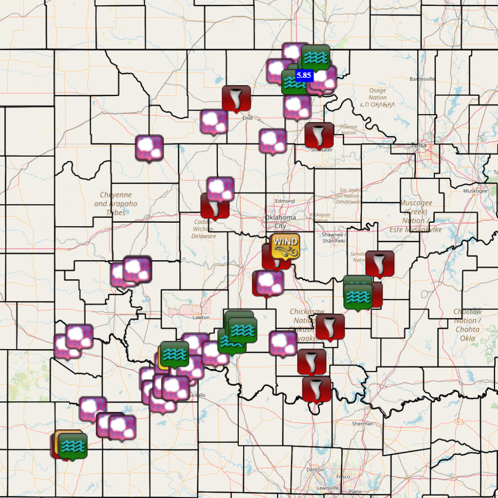
| Report Date |
Report Time (CST) |
Location | County | State | Event Type |
Mag. | Source | Lat. | Lon. | Remark |
|---|---|---|---|---|---|---|---|---|---|---|
| 04/27/2024 | 10:08 | 2 S Ringwood | Major | OK | Hail | 1.25 in. | Public | 36.35 | -98.25 | Report from mPING: Half Dollar (1.25 in.). |
| 04/27/2024 | 10:19 | 3 SSW Seiling | Dewey | OK | Hail | 1.75 in. | Emergency Mngr | 36.11 | -98.96 | |
| 04/27/2024 | 10:19 | 3 SW Seiling | Dewey | OK | Hail | 1.75 in. | Emergency Mngr | 36.12 | -98.96 | |
| 04/27/2024 | 11:49 | 2 E Goodlett | Hardeman | TX | Hail | 1.25 in. | Trained Spotter | 34.33 | -99.86 | |
| 04/27/2024 | 12:06 | 6 SW Eldorado | Jackson | OK | Hail | 1.00 in. | Trained Spotter | 34.42 | -99.73 | |
| 04/27/2024 | 12:21 | Hillsdale | Garfield | OK | Tornado | Emergency Mngr | 36.56 | -98.00 | Buildings and trees damaged. | |
| 04/27/2024 | 13:32 | 2 W Tonkawa | Kay | OK | Hail | 2.25 in. | Public | 36.70 | -97.35 | Report from mPING, time is radar estimated. |
| 04/27/2024 | 13:33 | 17 NE Benjamin | Knox | TX | Hail | 1.50 in. | Trained Spotter | 33.76 | -99.58 | Delayed Twitter Report. |
| 04/27/2024 | 13:35 | 2 W Tonkawa | Kay | OK | Hail | 1.25 in. | Public | 36.70 | -97.35 | Report from mPING. |
| 04/27/2024 | 13:35 | 1 N Tonkawa | Kay | OK | Hail | 1.75 in. | Public | 36.69 | -97.31 | Report from mPING. |
| 04/27/2024 | 13:38 | 1 S Hobart | Kiowa | OK | Hail | 1.00 in. | Public | 35.02 | -99.09 | Report from mPING, time is radar estimated. |
| 04/27/2024 | 13:39 | 1 NE Hobart | Kiowa | OK | Hail | 1.00 in. | Public | 35.04 | -99.09 | Report from mPING. |
| 04/27/2024 | 13:40 | 1 S Hobart | Kiowa | OK | Hail | 1.00 in. | Public | 35.02 | -99.09 | Report from mPING. |
| 04/27/2024 | 13:41 | 1 SE Lone Wolf | Kiowa | OK | Hail | 0.75 in. | Public | 34.98 | -99.24 | Report from mPING. |
| 04/27/2024 | 13:41 | Hobart | Kiowa | OK | Hail | 1.25 in. | Public | 35.03 | -99.10 | Report from mPING, time is radar estimated. |
| 04/27/2024 | 13:42 | 1 SE Blackwell | Kay | OK | Hail | 2.50 in. | Trained Spotter | 36.79 | -97.27 | Multiple Twitter Photos. |
| 04/27/2024 | 13:47 | 5 W Knox City | Knox | TX | Hail | 2.75 in. | Emergency Mngr | 33.42 | -99.90 | |
| 04/27/2024 | 14:06 | 3 W Knox City | Knox | TX | Tornado | Trained Spotter | 33.42 | -99.87 | tornado at FM 222 and 1292. | |
| 04/27/2024 | 14:10 | 3 NW Knox City | Knox | TX | Tstm Wnd Gst | 59 mph | Mesonet | 33.45 | -99.85 | |
| 04/27/2024 | 14:17 | 1 NW Braman | Kay | OK | Hail | 1.00 in. | Public | 36.94 | -97.35 | Report from mPING, time is radar estimated. |
| 04/27/2024 | 14:27 | 6 SW Morrison | Payne | OK | Tornado | Law Enforcement | 36.23 | -97.09 | 1 mile west of US-177, 1 mile south of Noble County line. | |
| 04/27/2024 | 14:52 | Deer Creek | Grant | OK | Hail | 0.75 in. | Public | 36.80 | -97.52 | Report from mPING. |
| 04/27/2024 | 15:08 | 6 W Seymour | Baylor | TX | Tornado | Trained Spotter | 33.61 | -99.39 | Delayed Report Tornado first sighted about 6-8 miles west of Seymour along SH114/US82 at 408PM, moved northeast and roped out near Lake Kemp at 440PM. | |
| 04/27/2024 | 15:13 | 1 E Red Springs | Baylor | TX | Hail | 1.00 in. | Public | 33.61 | -99.39 | Report from mPING, time is radar estimated. |
| 04/27/2024 | 15:30 | 5 ESE Geary | Canadian | OK | Tornado | Trained Spotter | 35.60 | -98.24 | Damage also reported about 4 miles NNW of Calumet. | |
| 04/27/2024 | 15:36 | 3 W Kildare | Kay | OK | Hail | 0.75 in. | Public | 36.80 | -97.10 | Report from mPING. |
| 04/27/2024 | 15:54 | 8 S Omega | Kingfisher | OK | Hail | 1.50 in. | Public | 35.75 | -98.18 | Report from mPING, time is radar estimated. |
| 04/27/2024 | 16:13 | 4 S Blackwell | Kay | OK | Flash Flood | Law Enforcement | 36.75 | -97.28 | US-177 is flooded north of US-60, all the way to Blackwell. Roadway may be partially washed out in places. | |
| 04/27/2024 | 16:23 | Electra | Wichita | TX | Hail | 1.50 in. | Law Enforcement | 34.03 | -98.92 | |
| 04/27/2024 | 16:34 | Knox City | Knox | TX | Hail | 1.25 in. | Public | 33.42 | -99.82 | Report from mPING. |
| 04/27/2024 | 16:42 | 1 E Knox City | Knox | TX | Flash Flood | Trained Spotter | 33.42 | -99.80 | Roads impassable in residential areas of Knox City; flooding over Hwy 222 and Hwy 6 in Knox City. | |
| 04/27/2024 | 16:44 | 6 NW Kamay | Wichita | TX | Hail | 1.00 in. | Public | 33.91 | -98.89 | Report from mPING. |
| 04/27/2024 | 16:47 | 6 NW Kamay | Wichita | TX | Hail | 1.75 in. | Public | 33.91 | -98.89 | Report from mPING. |
| 04/27/2024 | 16:48 | 2 NE Marshall | Garfield | OK | Hail | 1.75 in. | Broadcast Media | 36.18 | -97.60 | NWSChat Report. |
| 04/27/2024 | 16:52 | 5 S Peckham | Kay | OK | Flash Flood | Emergency Mngr | 36.81 | -97.17 | State Hwy 11 shut down between US Hwy 77 and Blackwell. | |
| 04/27/2024 | 17:05 | 5 SW Grandfield | Tillman | OK | Hail | 1.00 in. | Emergency Mngr | 34.17 | -98.75 | |
| 04/27/2024 | 17:10 | 2 WNW Tonkawa | Kay | OK | Flash Flood | Emergency Mngr | 36.70 | -97.35 | Flooding at US Hwy 60 and I-35, reducing I-35 down to one lane. | |
| 04/27/2024 | 17:20 | 3 W Ceres | Noble | OK | Hail | 1.00 in. | Trained Spotter | 36.48 | -97.33 | |
| 04/27/2024 | 17:40 | 2 W Grandfield | Tillman | OK | Tstm Wnd Gst | 60 mph | Emergency Mngr | 34.23 | -98.71 | |
| 04/27/2024 | 17:51 | 1 S Kamay | Wichita | TX | Hail | 1.50 in. | Public | 33.84 | -98.81 | Report from mPING, time is radar estimated. |
| 04/27/2024 | 17:52 | 6 WNW Iowa Park | Wichita | TX | Hail | 1.00 in. | Trained Spotter | 33.97 | -98.77 | |
| 04/27/2024 | 17:54 | 2 S Devol | Cotton | OK | Tornado | Trained Spotter | 34.16 | -98.59 | Visual cone tornado reported buried in precip. | |
| 04/27/2024 | 18:04 | 6 WNW Iowa Park | Wichita | TX | Hail | 1.25 in. | Public | 33.97 | -98.77 | Updated Report. |
| 04/27/2024 | 18:09 | Iowa Park | Wichita | TX | Hail | 1.50 in. | Emergency Mngr | 33.95 | -98.67 | NWSChat Report. |
| 04/27/2024 | 18:11 | 4 N Cookietown | Cotton | OK | Hail | 1.00 in. | Public | 34.34 | -98.45 | Report from mPING. |
| 04/27/2024 | 18:19 | 1 SW Burkburnett | Wichita | TX | Hail | 1.00 in. | Public | 34.08 | -98.59 | Report from mPING. |
| 04/27/2024 | 18:26 | 4 SW Randlett | Cotton | OK | Hail | 1.00 in. | Public | 34.14 | -98.51 | Report from mPING, time is radar estimated. |
| 04/27/2024 | 18:35 | Ponca City | Kay | OK | Hail | 2.50 in. | Public | 36.70 | -97.08 | picture on broadcast TV with measurement, time is radar estimated. |
| 04/27/2024 | 18:38 | 2 NNE Grandfield | Tillman | OK | Flash Flood | Emergency Mngr | 34.26 | -98.68 | High water crossing at County Road East West 1900 and US 36 north of Grandfield. | |
| 04/27/2024 | 18:39 | Ponca City | Kay | OK | Hail | 1.75 in. | Amateur Radio | 36.70 | -97.08 | NWSChat relayed report. |
| 04/27/2024 | 18:40 | 3 NE Ponca City | Kay | OK | Hail | 1.50 in. | Public | 36.74 | -97.05 | Report from mPING. |
| 04/27/2024 | 18:41 | Duncan | Stephens | OK | Hail | 1.00 in. | Public | 34.50 | -97.96 | Picture on Twitter. |
| 04/27/2024 | 19:03 | Temple | Cotton | OK | Hail | 1.00 in. | Fire Dept/Rescue | 34.27 | -98.23 | NWSChat Report. |
| 04/27/2024 | 19:18 | Iowa Park | Wichita | TX | Hail | 1.75 in. | Amateur Radio | 33.95 | -98.67 | NWSChat Report. |
| 04/27/2024 | 19:20 | 3 NNE Cole | McClain | OK | Tornado | Official NWS Obs | 35.15 | -97.56 | Delayed Report...Radar confirmed TDS, one of two in close proximity. | |
| 04/27/2024 | 19:35 | 3 NE Peckham | Kay | OK | Flash Flood | Emergency Mngr | 36.92 | -97.13 | Vehicle submerged in flood waters NW of the City of Newkirk. | |
| 04/27/2024 | 19:43 | 1 NW Duncan | Stephens | OK | Hail | 1.00 in. | Public | 34.52 | -97.97 | Report from mPING. |
| 04/27/2024 | 19:50 | Seymour | Baylor | TX | Hail | 1.00 in. | Emergency Mngr | 33.59 | -99.26 | NWSchat report. |
| 04/27/2024 | 19:53 | 3 ENE Bradley | McClain | OK | Tornado | Official NWS Obs | 34.90 | -97.67 | Tornado debris signature on radar. | |
| 04/27/2024 | 19:57 | 5 E Bradley | McClain | OK | Hail | 1.00 in. | Public | 34.91 | -97.63 | Report from mPING. |
| 04/27/2024 | 20:00 | 1 NW Duncan | Stephens | OK | Hail | 1.25 in. | Public | 34.52 | -97.97 | Report from mPING, time is radar estimated. |
| 04/27/2024 | 20:10 | Fox | Carter | OK | Hail | 3.00 in. | Fire Dept/Rescue | 34.36 | -97.49 | Corrects previous hail report from Fox for time to be radar estimate. NWSChat Report. |
| 04/27/2024 | 20:20 | 3 NNE Cole | McClain | OK | Tornado | Official NWS Obs | 35.14 | -97.56 | Tornado debris signature on radar. | |
| 04/27/2024 | 20:28 | 2 WNW Norman | Cleveland | OK | Tornado | Broadcast Media | 35.23 | -97.48 | Notable damage at Homeland; strong radar signature matches at this time; additional damage around Norman. | |
| 04/27/2024 | 20:35 | 2 NW Norman | Cleveland | OK | Tstm Wnd Gst | 59 mph | Mesonet | 35.24 | -97.46 | |
| 04/27/2024 | 20:37 | 2 NW Duncan | Stephens | OK | Flash Flood | Public | 34.52 | -97.98 | Report from mPING. | |
| 04/27/2024 | 20:37 | Duncan | Stephens | OK | Flash Flood | Public | 34.50 | -97.96 | Social media post showing water moving rapidly across Hwy 81 in Duncan. | |
| 04/27/2024 | 20:42 | Fox | Carter | OK | Hail | 3.00 in. | Fire Dept/Rescue | 34.36 | -97.49 | NWSChat Report. |
| 04/27/2024 | 20:57 | 2 WNW Ardmore | Carter | OK | Tornado | Public | 34.19 | -97.17 | Twitter Photo as tornado moved through Ardmore. | |
| 04/27/2024 | 21:05 | 3 S Empire City | Stephens | OK | Flood | Public | 34.38 | -98.05 | Report from mPING. | |
| 04/27/2024 | 21:07 | 3 N Duncan | Stephens | OK | Flash Flood | Public | 34.54 | -97.97 | Report from mPING. | |
| 04/27/2024 | 21:24 | Sulphur | Murray | OK | Tornado | Law Enforcement | 34.51 | -96.97 | Noticeable TDS as tornado moved through town. Widespread damage reported across Sulphur. | |
| 04/27/2024 | 21:38 | 6 SSE Francis | Pontotoc | OK | Tornado | Fire Dept/Rescue | 34.80 | -96.55 | ||
| 04/27/2024 | 21:39 | 1 W Holdenville | Hughes | OK | Tornado | Law Enforcement | 35.08 | -96.42 | Large TDS impacting western Holdenville, with widespread damage reported. | |
| 04/27/2024 | 21:39 | 1 W Holdenville | Hughes | OK | Tornado | Law Enforcement | 35.08 | -96.42 | *** 1 FATAL *** Large TDS impacting near Spaulding, western Holdenville and areas north of Holdenville. Widespread damage reported. | |
| 04/27/2024 | 21:51 | 2 SE Duncan | Stephens | OK | Flash Flood | Public | 34.48 | -97.93 | Report from mPING. | |
| 04/27/2024 | 22:10 | Marietta | Love | OK | Tornado | Emergency Mngr | 33.94 | -97.12 | Extensive damage to buildings and trees reported in Marietta. | |
| 04/27/2024 | 22:50 | 3 SSE Blackwell | Kay | OK | Rain | 5.85 in. | Mesonet | 36.77 | -97.26 | |
| 04/27/2024 | 23:37 | Byng | Pontotoc | OK | Flash Flood | Emergency Mngr | 34.86 | -96.67 | Vehicles stranded in the Byng area, with multiple roads closed due to high water through Ponotoc County. | |
| 04/27/2024 | 23:39 | Ada | Pontotoc | OK | Flash Flood | Emergency Mngr | 34.78 | -96.66 | Multiple reports of flooding through Ada, with streelights being taken down on Arlington Street. |
Severe Weather Update - April 25, 2024
Severe Weather Update - April 24, 2024