
Moderate to heavy mountain snow and strong winds are expected across the Northern Rockies. Lake effect snow will continue downwind of the Lower Great Lakes. Gusty winds and dry conditions will result in critical fire weather conditions in the Southwest and Southern Plains Wednesday through Friday. Extremely critical fire weather conditions are expected Thursday in portions of New Mexico. Read More >
During the late afternoon hours of May 11, 2023, thunderstorms formed in southwestern Oklahoma and near Wichita Falls in north Texas, and moved northeastward into central Oklahoma. Other supercell thunderstorms developed in central Oklahoma as the event progressed. Multiple supercell thunderstorms intensified and eventually produced hail of 1 to 1.25 inches in diameter and tornadoes. Tornadoes were reported in or near Tuttle, Bridge Creek, Rush Springs, Dibble, Cole, Noble, east Norman/Lake Thunderbird, and Maud.
Storm survey teams documented tornado damage paths in central Oklahoma on May 12, 2023. A total of 12 tornadoes occurred in central Oklahoma on May 11, 2023. Two tornadoes in the Cole-Goldsby and Noble areas were rated EF-1. Six other tornadoes in the Bridge Creek-Newcastle, Dibble, Maud and southeastern Norman areas were rated EF-0. A 9th tornado near Tuttle was given an EF-U (unknown) rating until more research can be conducted.
Research is ongoing for areas near Asher, Rush Springs, and Ninnekah.
A map and link to a KMZ file for the storm survey areas are available below. More information will be provided as it becomes available.


A closed, upper-level low/trough slowly lifted from the Four Corners region towards portions of the Front Range on May 11, 2023. At the surface, a low-pressure center slowly deepened through the day while translating from far southeast Colorado towards the Oklahoma Panhandle. A dryline was positioned across far western Oklahoma/western-north Texas by the afternoon, with warm front lifting towards the I-40 corridor/central Oklahoma.
During morning hours of the May 11th, a complex of thunderstorms developed across western-north Texas (near Vernon, TX). This shower/storm activity initially prevented the northward surge of rich Gulf of America moisture through the late morning hours and increased forecast uncertainty leading up to the event. However, by the early afternoon, broken to full solar insolation allowed for rapid northward advance of near-surface moisture into parts of central Oklahoma. The combination of increasing sunshine and moisture fostered increasing instability across the region, and acted to weaken the cap (layer of warm air aloft). With sufficient magnitudes of deep-layer wind shear in place, organized (supercell) storms developed by the early evening across southwest Oklahoma and eventually spread towards central Oklahoma/I-35 corridor by late evening.
While wind shear (especially in the lowest parts of the atmosphere) was not overly strong, a modest low-level jet increased toward 7 PM. This allowed multiple storms to become tornadic as they approached the I-35 corridor. Storm survey teams have identified multiple weak (EF-0/EF-1) tornado tracks across portions of Grady, McClain, Cleveland, and Pottawatomie Counties. The most significant tornadoes (both EF-1) affected portions of Cole, OK in McClain County and Noble, OK in Cleveland County. A few reports of severe hail were also received across portions of central Oklahoma through the evening.
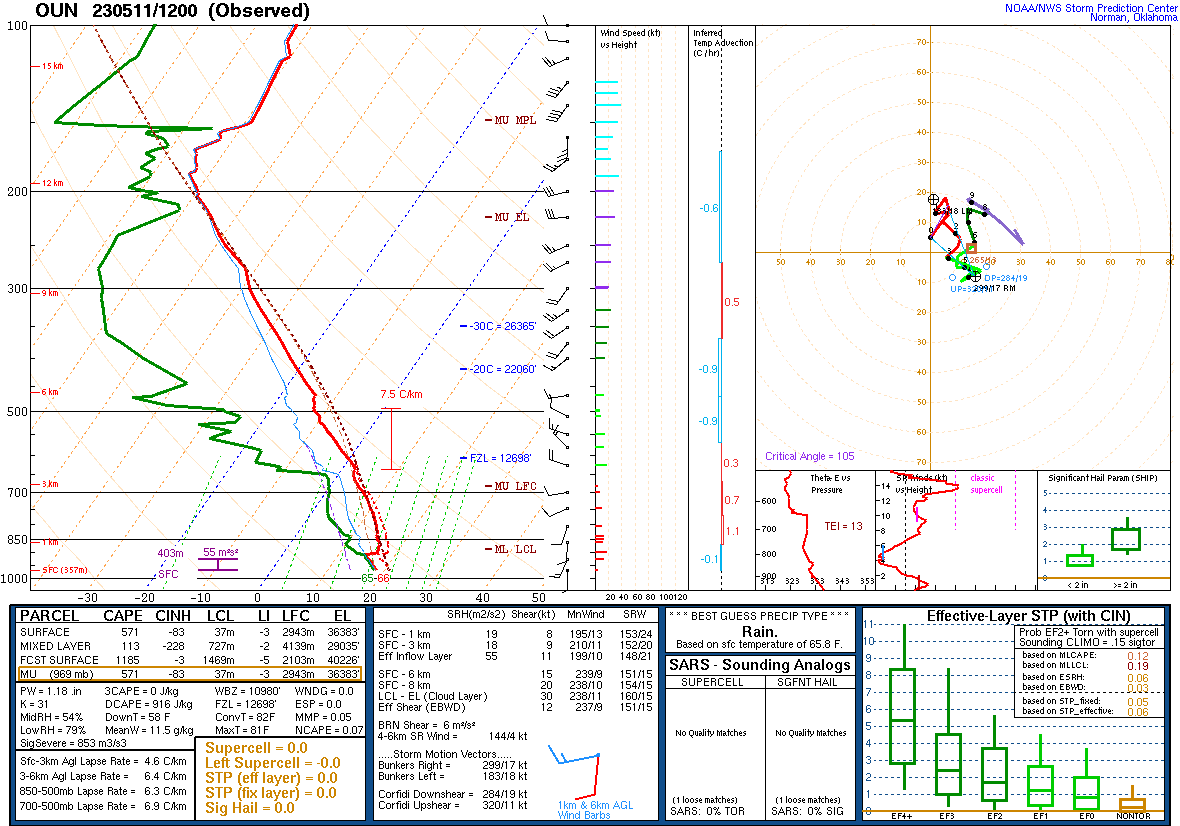 Upper Air Sounding for Norman, OK Upper Air Sounding for Norman, OKat 7 am CDT on 5/11/2023 |
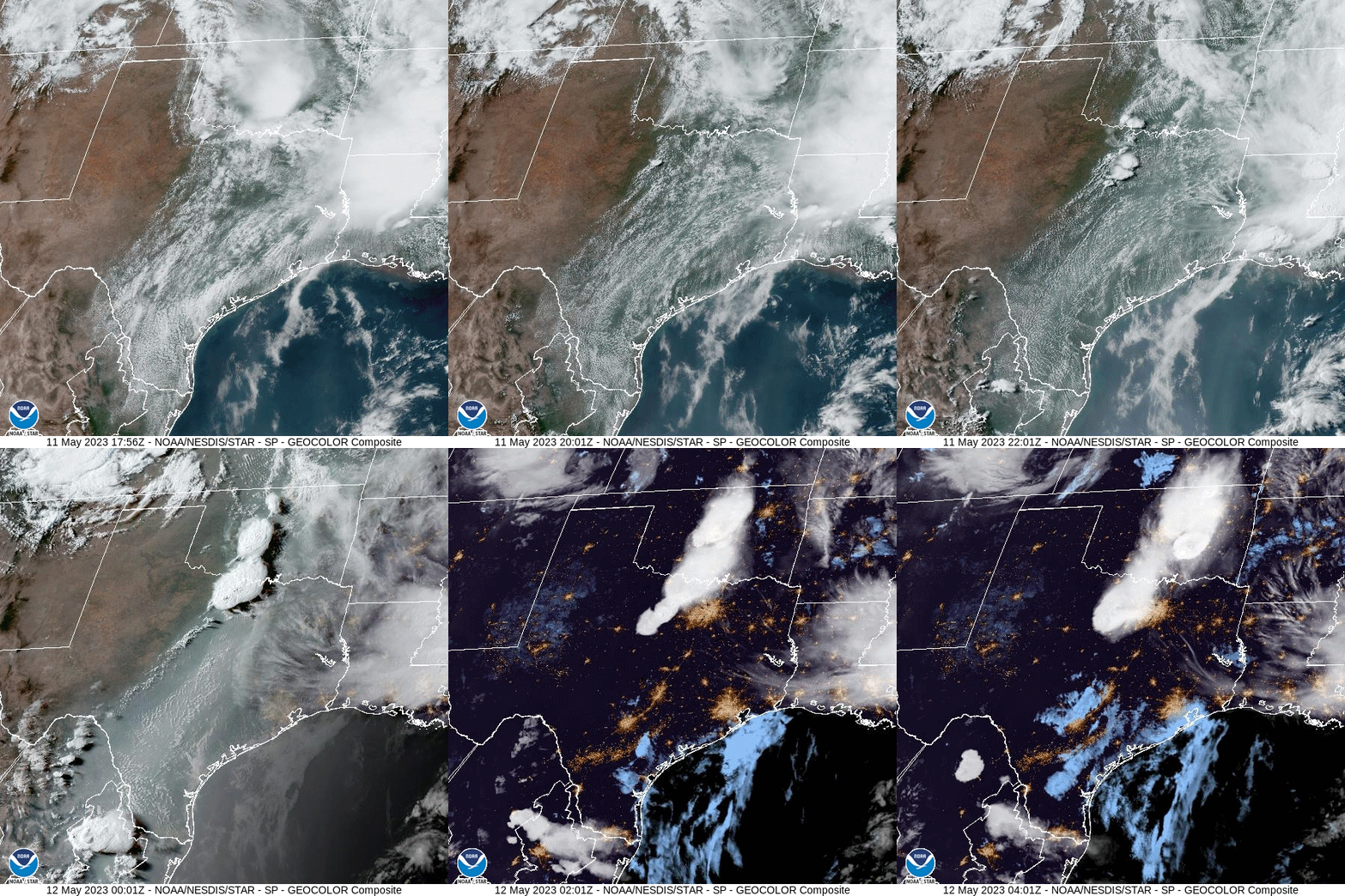 Regional Geocolor Satellite Loop from Regional Geocolor Satellite Loop from12:56 pm to 11:01 pm CDT on May 11, 2023 |
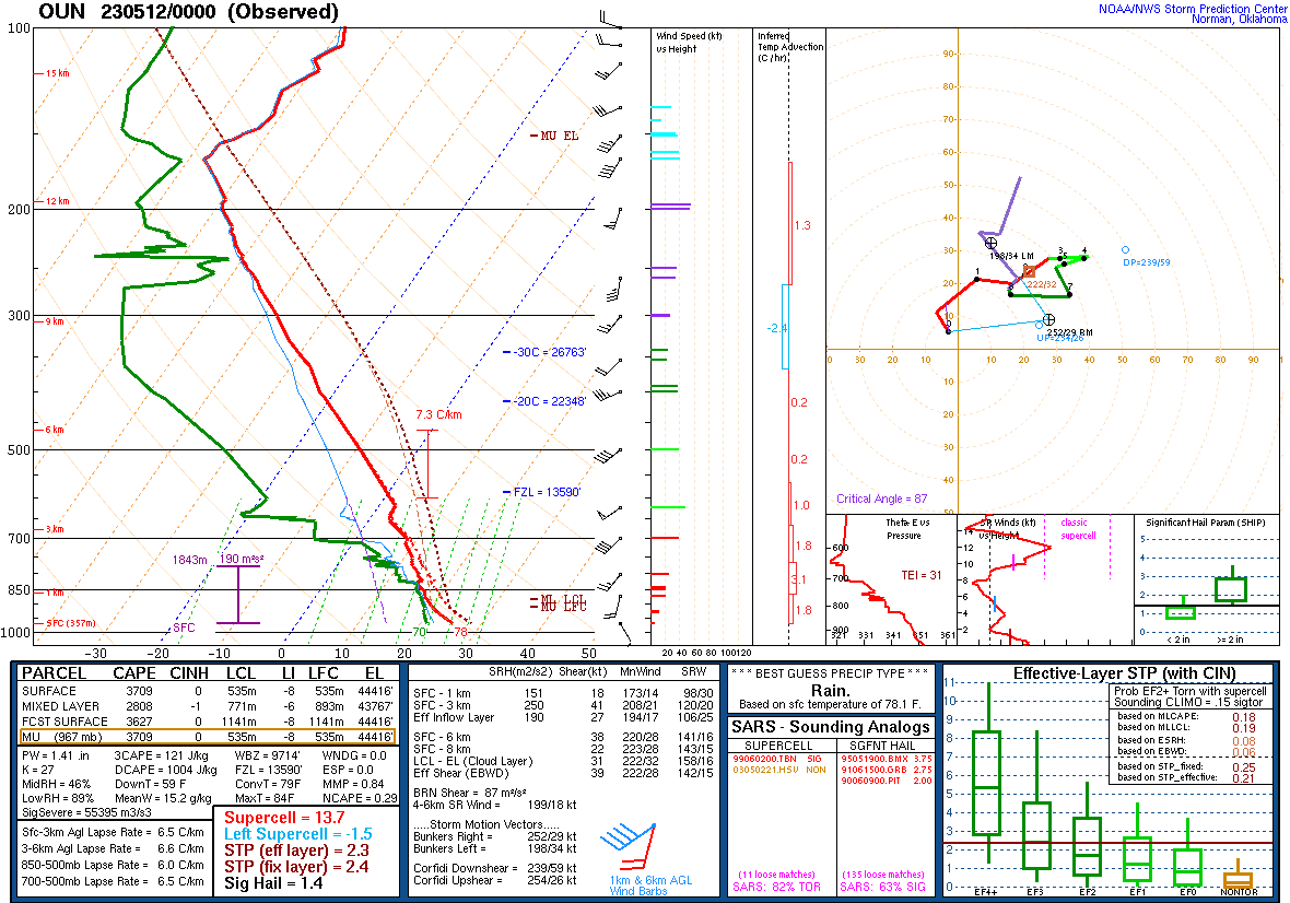 Upper Air Sounding for Norman, OK Upper Air Sounding for Norman, OKat 7 pm CDT on 5/11/2023 |
| Year | Total |
| 1992 | 24 |
| 1982 | 18 |
| 2023 | 12 |
| 2017 | 4 |
| 1999 | 4 |
NOUS44 KOUN 131819
PNSOUN
OKZ004>048-050>052-TXZ083>090-140630-

Public Information Statement
National Weather Service Norman OK
119 PM CDT Sat May 13 2023

...NWS Damage Survey for May 11, 2023 Tornado Event...

.Overview...Thunderstorms produced at least eight tornadoes on the
evening of Thursday, May 11th. Some of the tornadoes listed here
have been preliminary given an EF-Unknown rating for now, with
additional investigations to be done over the next few days to
determine a final rating. Additional areas near Rush Springs and
Lake Thunderbird are also being investigated.

Lastly, this statement will be updated early next week and some of
the individual tornado details remain subject to change.

.Cole-Goldsby...

Rating:                 EF1
Estimated Peak Wind:    100-105 mph
Path Length /statute/:  9.57 miles
Path Width /maximum/:   0 yards
Fatalities:             0
Injuries:               0

Start Date:             05/11/2023
Start Time:             08:29 PM CDT
Start Location:         3 SW Cole / McClain County / OK
Start Lat/Lon:          35.0706 / -97.603

End Date:               05/11/2023
End Time:               08:59 PM CDT
End Location:           1 W Goldsby / McClain County / OK
End Lat/Lon:            35.147 / -97.4964

Survey Summary:

.Noble...

Rating:                 EF1
Estimated Peak Wind:    100-105 mph
Path Length /statute/:  2.32 miles
Path Width /maximum/:   250 yards
Fatalities:             0
Injuries:               0

Start Date:             05/11/2023
Start Time:             09:04 PM CDT
Start Location:         1 WNW Noble / Cleveland County / OK
Start Lat/Lon:          35.1418 / -97.4089

End Date:               05/11/2023
End Time:               09:12 PM CDT
End Location:           2 NE Noble / Cleveland County / OK
End Lat/Lon:            35.156 / -97.373

Survey Summary:

.West of Maud...

Rating:                 EF0
Estimated Peak Wind:    70-75 mph
Path Length /statute/:  1.74 miles
Path Width /maximum/:   300 yards
Fatalities:             0
Injuries:               0

Start Date:             05/11/2023
Start Time:             10:21 PM CDT
Start Location:         2 W Maud / Pottawatomie County / OK
Start Lat/Lon:          35.129 / -96.8224

End Date:               05/11/2023
End Time:               10:26 PM CDT
End Location:           2 NW Maud / Pottawatomie County / OK
End Lat/Lon:            35.1523 / -96.8117

Survey Summary:

.Tuttle...

Rating:                 EF-U
Estimated Peak Wind:    N/A mph
Path Length /statute/:  N/A miles
Path Width /maximum/:   N/A yards
Fatalities:             0
Injuries:               0

Start Date:             05/11/2023
Start Time:             06:57 PM CDT
Start Location:         4 S Tuttle / Grady County / OK
Start Lat/Lon:          35.2362 / -97.7984

End Date:               05/11/2023
End Time:               07:08 PM CDT
End Location:           2 SE Tuttle / Grady County / OK
End Lat/Lon:            35.2646 / -97.7847

Survey Summary:

.SW of Dibble...

Rating:                 EF0
Estimated Peak Wind:    70-75 mph
Path Length /statute/:  1.52 miles
Path Width /maximum/:   75 yards
Fatalities:             0
Injuries:               0

Start Date:             05/11/2023
Start Time:             08:04 PM CDT
Start Location:         4 WSW Dibble / Grady County / OK
Start Lat/Lon:          34.9952 / -97.6964

End Date:               05/11/2023
End Time:               08:07 PM CDT
End Location:           3 WSW Dibble / Grady County / OK
End Lat/Lon:            35.0159 / -97.6869

Survey Summary:

.Newcastle #1...

Rating:                 EF0
Estimated Peak Wind:    70-75 mph
Path Length /statute/:  0.33 miles
Path Width /maximum/:   30 yards
Fatalities:             0
Injuries:               0

Start Date:             05/11/2023
Start Time:             07:38 PM CDT
Start Location:         3 ESE Bridge Creek / McClain County / OK
Start Lat/Lon:          35.2107 / -97.6661

End Date:               05/11/2023
End Time:               07:38 PM CDT
End Location:           3 ESE Bridge Creek / McClain County / OK
End Lat/Lon:            35.2122 / -97.6606

Survey Summary:

.Newcastle #2...

Rating:                 EF0
Estimated Peak Wind:    75-80 mph
Path Length /statute/:  2.14 miles
Path Width /maximum/:   30 yards
Fatalities:             0
Injuries:               0

Start Date:             05/11/2023
Start Time:             07:42 PM CDT
Start Location:         4 SW Newcastle / McClain County / OK
Start Lat/Lon:          35.2114 / -97.6535

End Date:               05/11/2023
End Time:               07:49 PM CDT
End Location:           2 SSW Newcastle / McClain County / OK
End Lat/Lon:            35.222 / -97.6185

Survey Summary:

.West of Dibble...

Rating:                 EF0
Estimated Peak Wind:    70-75 mph
Path Length /statute/:  0.43 miles
Path Width /maximum/:   0 yards
Fatalities:             0
Injuries:               0

Start Date:             05/11/2023
Start Time:             08:11 PM CDT
Start Location:         2 W Dibble / McClain County / OK
Start Lat/Lon:          35.0278 / -97.6668

End Date:               05/11/2023
End Time:               08:13 PM CDT
End Location:           2 W Dibble / McClain County / OK
End Lat/Lon:            35.0314 / -97.6606

Survey Summary:

&&

EF Scale: The Enhanced Fujita Scale classifies tornadoes into the
following categories:

EF0...Weak......65 to 85 mph
EF1...Weak......86 to 110 mph
EF2...Strong....111 to 135 mph
EF3...Strong....136 to 165 mph
EF4...Violent...166 to 200 mph
EF5...Violent...>200 mph

NOTE:
The information in this statement is preliminary and subject to
change pending final review of the events and publication in
NWS Storm Data.


$$
|

Storm survey teams documented tornado damage paths in central Oklahoma on May 12, 2023. At least 9 tornadoes occurred in central Oklahoma on May 11, 2023. Two tornadoes in the Cole-Goldsby and Noble areas were rated EF-1. Six other tornadoes in the Bridge Creek-Newcastle, Dibble, Maud, and southeastern Norman areas were rated EF-0. A 9th tornado near Tuttle was given an EF-U (unknown) rating until research can be conducted.
| Tornadoes by Intensity | |||||||
|---|---|---|---|---|---|---|---|
| EFU | EF0 | EF1 | EF2 | EF3 | EF4 | EF5 | Total |
| 3 | 7 | 2 | 0 | 0 | 0 | 0 | 12 |
| Tornado Number |
Date | Time (CST) |
Length of Path (miles) |
Width of Path (yards) |
F-Scale | Killed | Injured | County | Location |
|---|---|---|---|---|---|---|---|---|---|
| 1 | 05/11/2023 | 1724-1726 | 1 | 20 | EF0 | 0 | 0 | Grady | 1 N Norge |
| 2 | 05/11/2023 | 1757-1808 | 2.8 | 50 | EFU | 0 | 0 | Grady | 4 S - 2 SE Tuttle |
| 3 | 05/11/2023 | 1836-1838 | 0.4 | 30 | EF0 | 0 | 0 | Grady/ McClain | 3.5 SE Bridge Creek |
| 4 | 05/11/2023 | 1842-1849 | 2.1 | 30 | EF0 | 0 | 0 | McClain | 4 SW - 2.5 SSW Newcastle |
| 5 | 05/11/2023 | 1845-1845 | 0.2 | 20 | EFU | 0 | 0 | Grady | 2 NNW Rush Springs |
| 6 | 05/11/2023 | 1904-1907 | 1.5 | 75 | EF0 | 0 | 0 | Grady | 4.5 SW - 3.5 SSW Dibble |
| 7 | 05/11/2023 | 1912-1913 | 0.4 | 30 | EF0 | 0 | 0 | McClain | 2 W Dibble |
| 8 | 05/11/2023 | 1929-1959 | 9 | 250 | EF1 | 0 | 0 | McClain | 3 SW Cole - 1 SW Goldsby |
| 9 | 05/11/2023 | 2003-2013 | 2.3 | 300 | EF1 | 0 | 0 | Cleveland | 1 W Noble - Noble - 1.5 NE Noble |
| 10 | 05/11/2023 | 2033-2033 | 0.2 | 25 | EF0 | 0 | 0 | Cleveland | Southeast Norman (S of SH-9 ahd 96th Ave SE) |
| 11 | 05/11/2023 | 2047-2048 | 0.2 | 50 | EFU | 0 | 0 | Pottawatomie | 4 NNW Asher |
| 12 | 05/11/2023 | 2116-2121 | 1.7 | 300 | EF0 | 0 | 0 | Pottawatomie | 2.5 W - 2.5 NW Maud |

| Report Date |
Report Time (CST) |
Location | County | State | Event Type |
Mag. | Source | Lat. | Lon. | Remark |
|---|---|---|---|---|---|---|---|---|---|---|
| 5/11/2023 | 16:20 | 4 W Temple | Cotton | OK | Hail | 1.00 in. | Broadcast Media | 34.27 | -98.30 | |
| 5/11/2023 | 18:00 | 3 SSE Tuttle | Grady | OK | Tornado | Broadcast Media | 35.25 | -97.79 | ||
| 5/11/2023 | 18:35 | 3 SE Bridge Creek | Grady | OK | Tornado | Broadcast Media | 35.20 | -97.68 | Broadcast media report of a tornado. Time estimated by radar for the start of this tornado. Investigating several small circulations in this area. | |
| 5/11/2023 | 18:42 | 3 NNW Rush Springs | Grady | OK | Tornado | Public | 34.82 | -97.97 | Brief tornado | |
| 5/11/2023 | 19:04 | 4 SW Dibble | Grady | OK | Tornado | Public | 34.99 | -97.69 | ||
| 5/11/2023 | 19:37 | 1 W Moore | Cleveland | OK | Hail | 1.25 in. | Trained Spotter | 35.34 | -97.50 | Delayed report from 7:27 pm CST. Half dollar sized Hail reported in Moore. |
| 5/11/2023 | 19:42 | 1 SE Cole | McClain | OK | Tornado | Trained Spotter | 35.09 | -97.56 | ||
| 5/11/2023 | 20:07 | Noble | Cleveland | OK | Tornado | Trained Spotter | 35.15 | -97.39 | Spotter network report of Tornado in Noble. | |
| 5/11/2023 | 20:33 | 5 WSW Lake Thunderbird | Cleveland | OK | Tornado | Broadcast Media | 35.19 | -97.32 | Spotters and broadcast media report a tornado southwest of Lake Thunderbird. | |
| 5/11/2023 | 21:00 | 2 SSE Noble | Cleveland | OK | Hail | 1.00 in. | Trained Spotter | 35.11 | -97.38 | Spotter network report. |
| 5/11/2023 | 21:09 | 1 N Bowlegs | Seminole | OK | Hail | 1.00 in. | Emergency Mngr | 35.16 | -96.67 | |
| 5/11/2023 | 21:21 | 3 W Maud | Pottawatomie | OK | Tornado | Trained Spotter | 35.13 | -96.83 | Spotters and broadcast media observed a tornado approximately 3 miles west of Maud. | |
| 5/11/2023 | 22:03 | 1 N Stonewall | Pontotoc | OK | Hail | 1.00 in. | Emergency Mngr | 34.67 | -96.53 |


Severe Weather Update - 12:00 pm CST, May 11, 2023
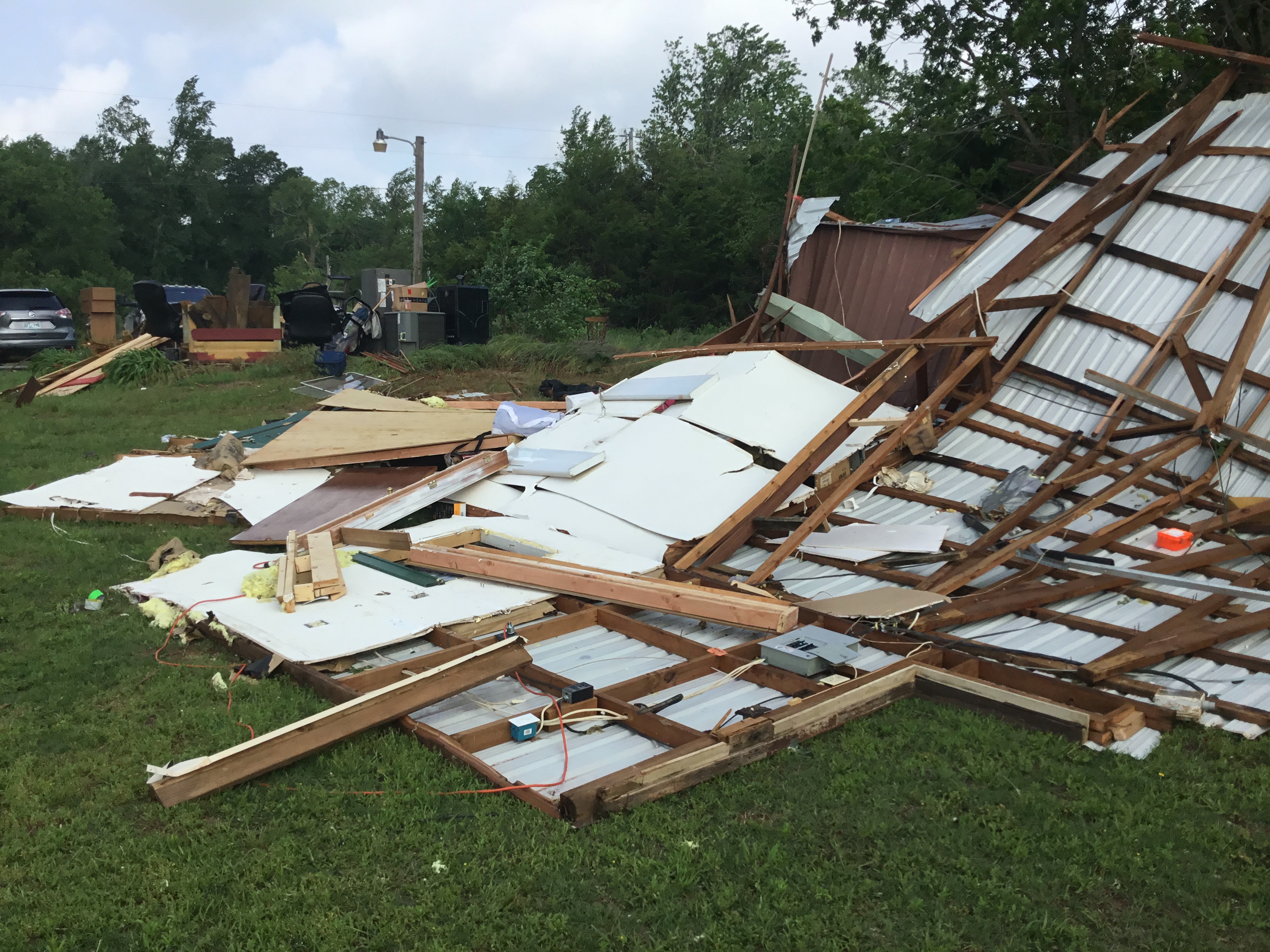 Photo #1: View looking at the destruction of an outbuilding on a residence east-southeast of Cole, OK. |
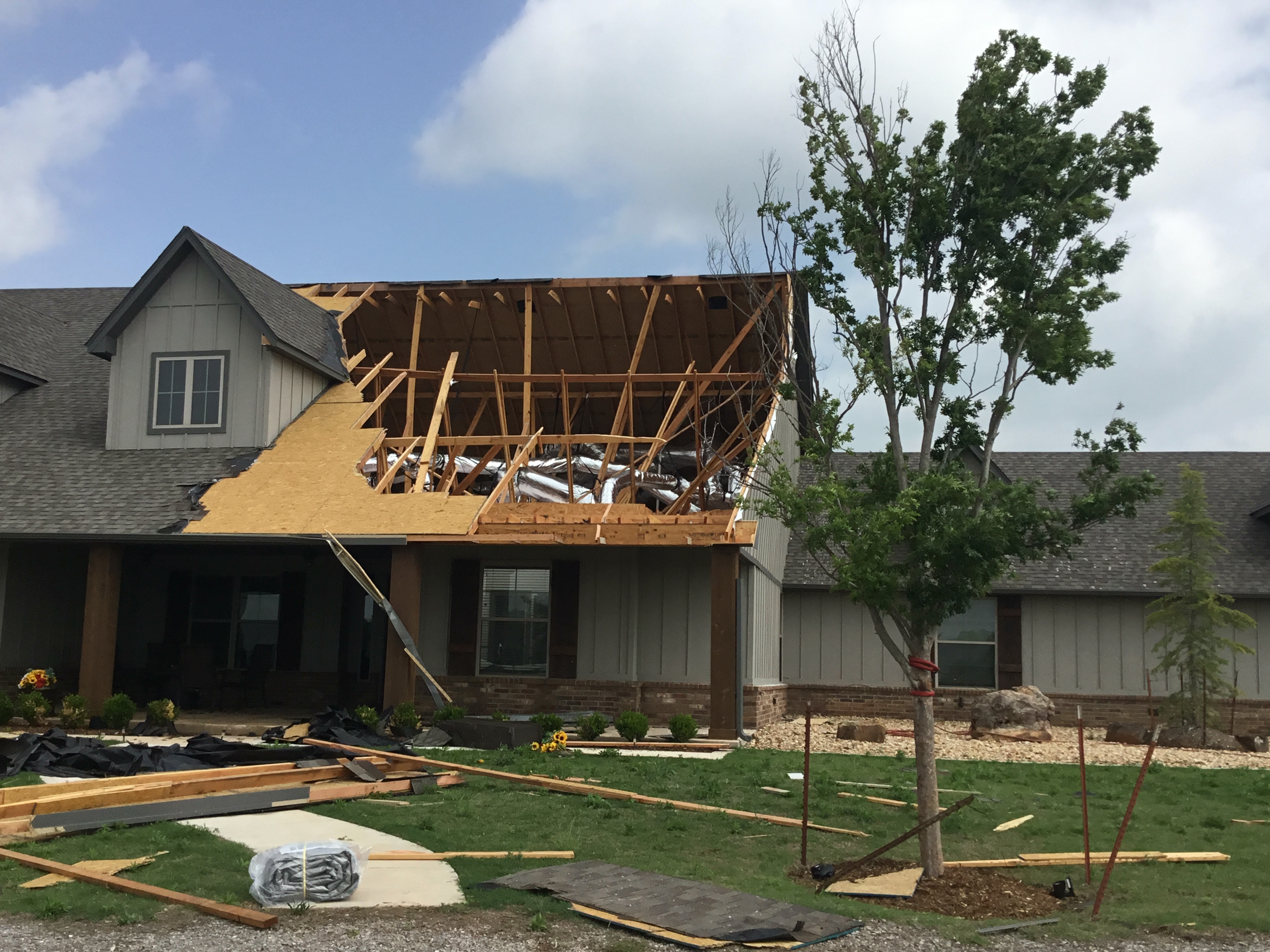 Photo #2: View looking at roof damage to a house east-southeast of Cole, OK. |
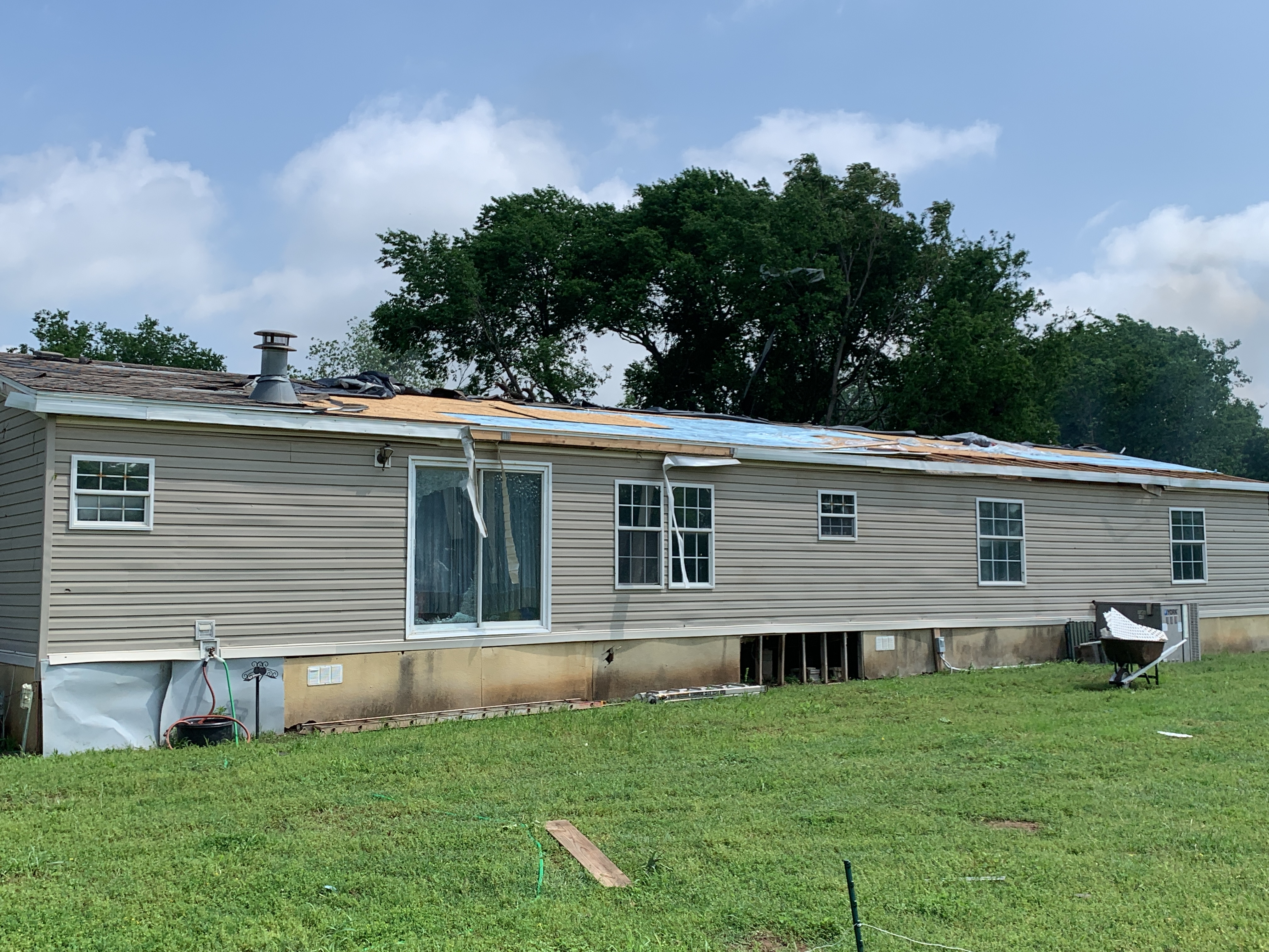 Photo #3: View looking at roof damage to a double wide manufactured home east-southeast of Cole, OK. |
 Photo #1: View looking at roof damage to a business in Noble, OK. |
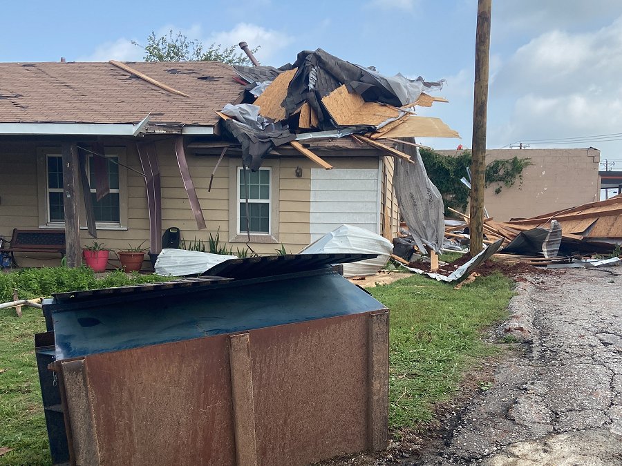 Photo #2: View looking at roof damage to a house in Noble, OK. |
 Photo #3: View of a utility crew repairing broken utility poles in Noble, OK. |
 Photo #4: View looking at roof damage to a business in Noble, OK. |