Strong to severe thunderstorms will continue tonight across portions of the Ohio Valley into the Mid-Atlantic. Heavy rains may bring an isolated flash flooding threat over the central Appalachians, particularly in West Virginia. Moderate to heavy snow will continue over portions of northern Minnesota and the Upper Peninsula of Michigan through Tuesday morning. Read More >
Severe thunderstorms developed along and ahead of a dry line across central Oklahoma during the afternoon of May 9, 2016. The storms moved across central and eastern Oklahoma during the late afternoon evening hours. Prior to the storms moving into the area, the atmosphere ahead of the dry line in central and eastern Oklahoma had become very unstable.
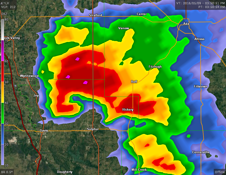
This instability, combined with very strong wind shear associated with a strong trough of low pressure that moved into the Southern Plains from the Southern Rockies, resulted in the development of supercell thunderstorms. Several of these supercells produced a dozen tornadoes. Some of these tornadoes were damaging and long-lived tornadoes, and two were also killer tornadoes. One of the tornadoes, the "Katie tornado", killed one person and was rated EF-4. Another tornado that occurred in Johnston and Coal counties also killed one person and was rated EF-3.
One of the supercells produced multiple tornadoes as it tracked along and near an outflow boundary produced earlier by morning thunderstorms associated with a previous weather system. This outflow boundary had settled across southeastern Oklahoma by the afternoon. The most significant tornado associated with this thunderstorm was the EF-3 tornado which occurred near the towns of Bennington and Boswell.
In addition to the tornadoes in central and southeastern Oklahoma, the severe thunderstorms produced hail up to baseball size and damaging wind gusts across other portions of central and eastern Oklahoma.
A tornado developed 1.25 miles south of the community of Katie, Oklahoma, or about 3.4 miles north of Hennepin in Garvin County. The tornado was observed to be very dynamic as it moved east-northeast and east. Initially damage was confined to trees until the tornado crossed county road 1690 where a home was destroyed where only interior walls remained standing. To the east of this house, two mobile homes were damaged on the southern periphery of the tornado path. The tornado moved east-northeast damaging another mobile home, then east removing the roof from a home on Indian Meridian Road.
The tornado varied in movement between northeast and southeast as it approached and crossed county road 1680. A home was destroyed near county road 1680 and Indian Meridian Road where an EF4 rating was applied (DI 2, DOD 9). Further east, a fatality occurred when the tornado destroyed a modular home. After destroying another home, the tornado moved northeast and dissipated near Interstate 35.


Photos of damage produced by EF-4 tornado that occurred on May 9, 2016 near the town of Katie in Gavin County, Oklahoma can be found in the "Damage" tab.
Tornadoes by Intensity |
|||||||
|---|---|---|---|---|---|---|---|
| EFU | EF0 | EF1 | EF2 | EF3 | EF4 | EF5 | Total |
| 5 | 0 | 2 | 1 | 3 | 1 | 0 | 12 |
| Tornado Number |
Date | Time (CST) |
Length of Path (miles) |
Width of Path (yards) |
F-Scale | Killed | Injured | County | Location |
|---|---|---|---|---|---|---|---|---|---|
| 1 | 05/09/2016 | 1506-1527 | 9 | 400 | EF4 | 1 | 0 | Garvin | 1.25 S - 8 E Katie |
| 2 | 05/09/2016 | 1534-1617 | 17 | 1500 | EF3 | 0 | 0 | Murray/ Pontotoc | 4 NNW Davis - 2.5 SSW Roff |
| 3 | 05/09/2016 | 1616-1616 | 0.1 | 10 | EF? | 0 | 0 | Cleveland | Lake Thunderbird |
| 4 | 05/09/2016 | 1618-1625 | 1.5 | 40 | EF? | 0 | 0 | Johnston | 7.5 W - 6 W Pontotoc |
| 5 | 05/09/2016 | 1618-1636 | 9 | 700 | EF3 | 1 | 0 | Johnston/ Coal | 4 S Connerville - Bromide |
| 6 | 05/09/2016 | 1646-1719 | 12 | 900 | EF1 | 0 | 0 | Atoka/ Coal/ Atoka | 12 WNW - 5 N Atoka |
| 7 | 05/09/2016 | 1647-1647 | 0.5 | 25 | EF? | 0 | 0 | Atoka | 4 ENE Wapanucka |
| 8 | 05/09/2016 | 1658-1720 | 6 | 600 | EF2 | 0 | 0 | Noble/ Payne/ Noble | 6 SE Perry - 6 WSW Morrison |
| 9 | 05/09/2016 | 1724-1742 | 13.8 | 3100 | EF3 | 0 | 2 | Bryan/ Choctaw | 3.6 ESE Bennington - 6.4 ESE Boswelll |
| 10 | 05/09/2016 | 1802-1810 | 6.1 | 650 | EF1 | 0 | 0 | Choctaw | 3.1 W - 3 E Hugo |
| 11 | 05/09/2016 | 1818-1830 | 6 | 150 | EF? | 0 | 0 | Choctaw | 6.3 NW Sawyer - 2.4 S Spencerville |
| 12 | 05/09/2016 | 1825-1826 | 0.5 | 75 | EF? | 0 | 0 | Choctaw | 4.3 NNW - 4.4 N Sawyer |
PRELIMINARY LOCAL STORM REPORT
NATIONAL WEATHER SERVICE NORMAN OK

..TIME...   ...EVENT...      ...CITY LOCATION...     ...LAT.LON...
..DATE...   ....MAG....      ..COUNTY LOCATION..ST.. ...SOURCE....
            ..REMARKS..

0357 PM     HAIL             3 N ELMORE CITY         34.67N 97.40W
05/09/2016  E1.75 INCH       GARVIN             OK   FIRE DEPT/RESCUE

0401 PM     HAIL             THACKERVILLE            33.79N 97.14W
05/09/2016  E1.25 INCH       LOVE               OK   PUBLIC

            RELAYED VIA TWITTER.

0404 PM     TORNADO          4 NNW HENNEPIN          34.56N 97.36W
05/09/2016                   GARVIN             OK   BROADCAST MEDIA

0410 PM     HAIL             2 E LAHOMA              36.39N 98.05W
05/09/2016  E1.25 INCH       GARFIELD           OK   EMERGENCY MNGR

0410 PM     HAIL             INGERSOLL               36.80N 98.39W
05/09/2016  E1.25 INCH       ALFALFA            OK   STORM CHASER

0420 PM     HAIL             3 SE NORMAN             35.19N 97.40W
05/09/2016  E1.00 INCH       CLEVELAND          OK   NWS EMPLOYEE

0420 PM     HAIL             1 SSW MOORE             35.33N 97.49W
05/09/2016  E1.00 INCH       CLEVELAND          OK   LAW ENFORCEMENT

0425 PM     HAIL             1 S EDMOND              35.64N 97.48W
05/09/2016  E1.00 INCH       OKLAHOMA           OK   TRAINED SPOTTER

0430 PM     HAIL             EDMOND                  35.65N 97.48W
05/09/2016  E1.00 INCH       OKLAHOMA           OK   TRAINED SPOTTER

0435 PM     HAIL             2 S WYNNEWOOD           34.61N 97.16W
05/09/2016  E1.75 INCH       MURRAY             OK   STORM CHASER

0438 PM     TORNADO          5 N DAVIS               34.57N 97.12W
05/09/2016                   MURRAY             OK   STORM CHASER

0505 PM     TSTM WND GST     4 NNE SULPHUR           34.56N 96.95W
05/09/2016  M88 MPH          MURRAY             OK   MESONET

0515 PM     TORNADO          1 N LAKE THUNDERBIRD    35.24N 97.23W
05/09/2016                   CLEVELAND          OK   BROADCAST MEDIA

0515 PM     HAIL             STELLA                  35.32N 97.22W
05/09/2016  E1.75 INCH       CLEVELAND          OK   TRAINED SPOTTER

0516 PM     HAIL             3 NW ORLANDO            36.18N 97.41W
05/09/2016  E1.00 INCH       NOBLE              OK   EMERGENCY MNGR

0521 PM     TORNADO          9 WSW BROMIDE           34.37N 96.64W
05/09/2016                   JOHNSTON           OK   EMERGENCY MNGR

0527 PM     HAIL             DURANT                  34.00N 96.39W
05/09/2016  E1.75 INCH       BRYAN              OK   EMERGENCY MNGR

0540 PM     HAIL             4 N WAPANUCKA           34.43N 96.42W
05/09/2016  E4.00 INCH       COAL               OK   PUBLIC

0550 PM     HAIL             3 W BLUE                34.00N 96.28W
05/09/2016  E1.50 INCH       BRYAN              OK   TRAINED SPOTTER

0552 PM     HAIL             BLUE                    34.00N 96.23W
05/09/2016  E2.50 INCH       BRYAN              OK   PUBLIC

0604 PM     HAIL             2 S LEHIGH              34.44N 96.22W
05/09/2016  E2.00 INCH       COAL               OK   TRAINED SPOTTER

0604 PM     FUNNEL CLOUD     3 S LEHIGH              34.43N 96.22W
05/09/2016                   COAL               OK   TRAINED SPOTTER

0605 PM     TORNADO          6 WNW ATOKA             34.42N 96.23W
05/09/2016                   ATOKA              OK   TRAINED SPOTTER

0605 PM     HAIL             2 WSW BOKCHITO          34.01N 96.17W
05/09/2016  M3.00 INCH       BRYAN              OK   TRAINED SPOTTER

0605 PM     TORNADO          3 NE LAKE MCMURTRY      36.19N 97.14W
05/09/2016                   PAYNE              OK   BROADCAST MEDIA

0609 PM     HAIL             4 SW LEHIGH             34.43N 96.27W
05/09/2016  E2.75 INCH       COAL               OK   CO-OP OBSERVER

0630 PM     TORNADO          3 SW STRINGTOWN         34.43N 96.09W
05/09/2016                   ATOKA              OK   TRAINED SPOTTER

0642 PM     HAIL             5 SSW RENFROW           36.86N 97.69W
05/09/2016  E1.75 INCH       GRANT              OK   STORM CHASER

0725 PM     HAIL             4 S BRAMAN              36.87N 97.33W
05/09/2016  E1.00 INCH       KAY                OK   EMERGENCY MNGR

0734 PM     HAIL             BLACKWELL               36.80N 97.28W
05/09/2016  E2.00 INCH       KAY                OK   BROADCAST MEDIA

            FALLING ON NORTH SIDE OF BLACKWELL.

0743 PM     HAIL             2 N BLACKWELL           36.83N 97.28W
05/09/2016  E1.75 INCH       KAY                OK   EMERGENCY MNGR

0804 PM     HAIL             NEWKIRK                 36.88N 97.06W
05/09/2016  E1.50 INCH       KAY                OK   PUBLIC

            RELAYED VIA MPING.

&&

$$
|


Shown below is a link to a 1-minute, satellite loop provided by Scott Bachmeier of the Cooperative Institute for Meteorological Satellite Studies (CIMSS) Satellite Blog. The link to the CIMSS Satellite blog for the May 9, 2016 tornado outbreak is available here. Click on the image below to view an MP4 animation.


The following photo was taken by former NWS Norman meteorologist Gabe Garfield. This EF-3 tornado traveled west to east across Murray County, Oklahoma, and north of the towns of Davis, Sulphur, and Hickory.
 |
The following video of the EF-3 "Sulphur Tornado" was also taken by former NWS Norman meteorologist Gabe Garfield.
The following photos were taken on May 10, 2016 by NWS personnel and Senior Engineer/Meteorologist Tim Marshall as they conducted a damage survey along the path of the EF-4 tornado that occurred on May 9, 2016 near the town of Katie in Gavin County, Oklahoma.
 |
 |
 |
 |
 |
 |
 |
 |
 |
 |
 |
 |
 |
 |
 |
 |
 |
 |
 |
 |
 |
 |
 |
 |
 |
 |
 |
 |
 |
 |
 |
 |
 |
 |
 |
 |
 |
 |
 |
 |