The day started stormy on Wednesday, May 25, 1955. Between 8:30 and 9:00 AM CDT, a thunderstorm produced damaging winds in Kay County where eyewitnesses estimated winds of 70-80 mph near Braman, Oklahoma. Unfortunately, this was a small taste of what the day would bring for some residents of north central Oklahoma.
These morning storms moved out of the area and weakened, but additional storms developed in the afternoon and produced a significant tornado outbreak across the Texas panhandle into Oklahoma and Kansas. The first significant tornado of the day, rated F4, developed northwest of Wellington TX and moved into western Oklahoma killing two people southwest of Cheyenne, OK. Over the next few hours, nearly 20 tornadoes were reported in Oklahoma: near Mayfield, Kingfisher, Camargo, and Deer Creek as storms moved north-northeast across the state.
At about 6:50 PM CDT, radar detected a new storm developing very close to Oklahoma City moving north. The storm moved north and produced the initial tornado touched down about 8 miles west of Marland around 9:00 PM CDT. It caused some light damage as it moved almost due north into Kay County. The tornado passed to the east and northeast of Tonkawa and destroyed a few homes while the storm also produced baseball-sized hail in Tonkawa.
The tornado continued north and moved through the east side of Blackwell causing complete destruction in much of the east side of town. Nineteen people were killed in Blackwell as well as one person to the northeast of Blackwell. The tornado passed east of Braman, then turned to the north-northwest and dissipated to the southeast of South Haven, Kansas as shown in tornado track map for north central Oklahoma and south central Kansas. As this storm passed to the east of Braman, another tornado developed about 4 miles north of Peckham that moved into Kansas and eventually killed 80 people in and near Udall, KS. Both the Blackwell tornado and Udall, KS tornado were rated F5, although the Udall tornado produced minimal damage in Oklahoma.
The tornado struck Blackwell at 9:27 PM CDT and destroyed the east side of town. Approximately 80 blocks in town were damaged or destroyed. The Blackwell Journal-Tribune newspaper conducted a building-by-building survey across the east side of town listing approximately 85 homes and buildings as "damaged, but occupied", about 70 homes and buildings as having "extensive damage, but repairable", and about 190 homes and buildings as "completely destroyed." The information from this extensive building-by-building survey was smoothed and used to create the damage intensity map of the tornado as it moved through Blackwell.
The width of “complete destruction” was likely much more extensive at the southern limits of the city as there would be little to block the force of the wind. Almost everything between "D" Street and "F" Street was completely destroyed, and over half of the fatalities in the city of Blackwell were within a block of "E" Street. Two of Blackwell's major industries (the Hazel Atlas Glass plant and the Acme Foundry) were destroyed and another was extensively damaged. The Riverside Osteopathic Hospital on East College Street suffered extensive damage and “doctors there labored for hours under candle light and flashlight and didn’t quit until they were certain that all patients were in position to be moved to another hospital,” according to the Blackwell Journal-Tribune.[1] A large number of police officers were already in the area that evening attending a meeting of the Northern Oklahoma Southern Kansas Peace Officers Association that evening.
To make matters worse, heavy rain that continued after the tornado hampered rescue work that evening and caused the Chickaskia River to flow out of its banks into some low sections of towns the following day. And four other tornadoes were reported in Kay and Grant Counties on the evening of May 27, just two days after the Blackwell disaster. Fortunately, this time these weak tornadoes stayed to the north of Blackwell and caused no injuries. When the warnings were sounded about this storm, “it was not necessary to tell people twice to get to a cellar” according to the newspaper account.[1]
One eyewitness in Blackwell had an interesting visual observation of the tornado. Floyd Montgomery lived nine blocks west of the main path of the tornado and submitted his account to Weatherwise magazine in June 1956. Mr. Montgomery describes as he looked to the east from the door of his storm cellar as the tornado moved through Blackwell. He described a “fire up near the top of the funnel looked like a child’s Fourth of July pin wheel. The light was so intense I had to look away.” He describes the light as the “same color as an electric arc welder but much brighter, and it seemed to be turning to the right like a beacon lamp on a light house.”
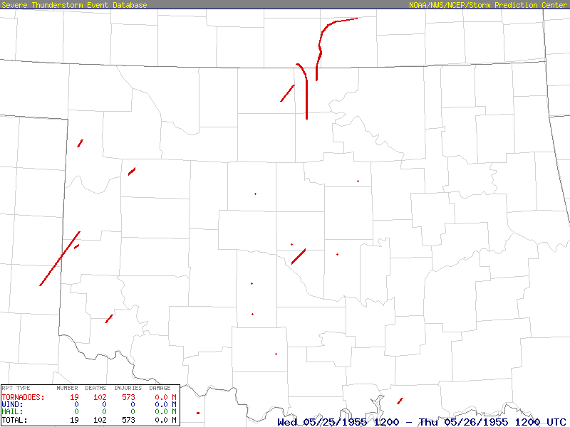 Track Map for Tornadoes That Occurred in Oklahoma During the May 25-26, 1995 Tornado Outbreak
 Track of the 2 F5 Tornadoes for the May 25-26, 1995 Tornado Outbreak
 Recreation of a Damage Map in Blackwell, OK for the May 25, 1955 F5 Tornado
| May 25-26, 1955 Tornadoes by Intensity | ||||||
|---|---|---|---|---|---|---|
| F0 | F1 | F2 | F3 | F4 | F5 | Total |
| 5 | 8 | 2 | 1 | 1 | 2 | 19 |
| # | Date | Time (CST) |
Path Length (miles) |
Path Width (yards) |
F- Scale |
Killed | Injured | County | Location | ||
|---|---|---|---|---|---|---|---|---|---|---|---|
| 1 | 05/25/1955 | 1800 | 5 | 400 | F1 | 0 | 0 | Ellis | Near Shattuck | ||
| 2 | 05/25/1955 | 1800 | N/A | N/A | F1 | 0 | 0 | Grady | Near Rush Springs | ||
| 3 | 05/25/1955 | 1700 | 46 | 1100 | F4 | 2 | 18 (8) |
Collingsworth TX/ Wheeler TX/ Roger Mills | 10 N Wellington TX - 12 SW of Cheyenne | ||
| 4 | 05/25/1955 | 1805 | 4 | 300 | F0 | 0 | 0 | Beckham | Near Mayfield | ||
| 5 | 05/25/1955 | 1900 | N/A | N/A | F1 | 0 | 0 | Kingfisher | Near Kingfisher | ||
| 6 | 05/25/1955 | 2030 | 5 | 300 | F2 | 0 | 1 | Dewey | Near Camargo | ||
| 7 | 05/25/1955 | 2100 | 13 | 440 | F3 | 0 | 1 | Grant | Deer Creek | ||
| 8 | 05/25/1955 | 2100 | 3 | 500 | F2 | 0 | 0 | Kay | NE of Tonkawa * | ||
| 9 | 05/25/1955 | 2126 | 28 | 500 | F5 | 20 | 280 | Kay/ Sumner KS | Blackwell - into Kansas | ||
| 10 | 05/25/1955 | 2200 | 56 | 1320 | F5 | 80 (0) |
273 (0) |
Kay/ Sumner KS/ Cowley KS | S of Ashton KS - Udall KS - N of Atlanta KS | ||
| 11 | 05/25/1955 | 2300 | 6 | 300 | F1 | 0 | 0 | Jackson | Near Duke | ||
| 12 | 05/26/1955 | 0230 | N/A | N/A | F0 | 0 | 0 | Stephens | Near Velma | ||
| 13 | 05/26/1955 | 0230 | N/A | N/A | F1 | 0 | 0 | Grady | Near Chickasha | ||
| 14 | 05/26/1955 | 0300 | 0.5 | 50 | F1 | 0 | 0 | Oklahoma | SE part of Oklahoma City | ||
| 15 | 05/26/1955 | 0300 | 12 | 17 | F1 | 0 | 0 | Cleveland | Near Norman | ||
| 16 | 05/26/1955 | 0330 | N/A | N/A | F0 | 0 | 0 | Pottawatomie | Near Shawnee | ||
| 17 | 05/26/1955 | 0400 | N/A | N/A | F0 | 0 | 0 | Payne | Near Cushing | ||
| 18 | 05/26/1955 | 0520 | 5 | 50 | F0 | 0 | 0 | Bryan | Near Durant | ||
| 19 | 05/26/1955 | 0645 | 14 | 400 | F1 | 0 | 2 | Sequoyah | Sallisaw | ||
| * The tornado track officially listed near Tonkawa is probably part of the Blackwell tornado track. | |||||||||||
| May 25-26, 1955 Tornadoes by Intensity | ||||||
|---|---|---|---|---|---|---|
| F0 | F1 | F2 | F3 | F4 | F5 | Total |
| 5 | 8 | 4 | 1 | 1 | 2 | 21 |
| # | Date | Time (CST) |
Path Length (miles) |
Path Width (yards) |
F- Scale |
Killed | Injured | County | Location |
|---|---|---|---|---|---|---|---|---|---|
| 1 | 05/25/1955 | 1800 | 5 | 400 | F1 | 0 | 0 | Ellis | Near Shattuck |
| 2 | 05/25/1955 | 1800 | N/A | N/A | F1 | 0 | 0 | Grady | Near Rush Springs |
| 3 | 05/25/1955 | 1700 | 46 | 1100 | F4 | 2 | 18 (8) |
Collingsworth TX/ Wheeler TX/ Roger Mills | 10 N Wellington TX - 12 SW of Cheyenne |
| 4 | 05/25/1955 | 1805 | 4 | 300 | F0 | 0 | 0 | Beckham | Near Mayfield |
| 5 | 05/25/1955 | 1900 | N/A | N/A | F1 | 0 | 0 | Kingfisher | Near Kingfisher |
| 6 | 05/25/1955 | 2030 | 5 | 300 | F2 | 0 | 1 | Dewey | Near Camargo |
| 7 | 05/25/1955 | 2100 | 13 | 440 | F3 | 0 | 1 | Grant | Deer Creek |
| 8 | 05/25/1955 | 2100 | 3 | 500 | F2 | 0 | 0 | Kay | NE of Tonkawa |
| 9 | 05/25/1955 | 2126 | 28 | 500 | F5 | 20 | 280 | Kay/ Sumner KS | Blackwell - into Kansas |
| 10 | 05/25/1955 | 2200 | 56 | 1320 | F5 | 80 (0) |
273 (0) |
Kay/ Sumner KS/ Cowley KS | S of Ashton KS - Udall KS - N of Atlanta KS |
| 11 | 05/25/1955 | 2300 | 6 | 300 | F1 | 0 | 0 | Jackson | Near Duke |
| 12 | 05/25/1955 | 2330 | 12 | 300 | F2 | 0 | 0 | Knox, TX | 9 W Knox City |
| 13 | 05/26/1955 | 0138 | 1.3 | 33 | F2 | 0 | 0 | Wichita, TX | Near Wichita Falls |
| 14 | 05/26/1955 | 0230 | N/A | N/A | F0 | 0 | 0 | Stephens | Near Velma |
| 15 | 05/26/1955 | 0230 | N/A | N/A | F1 | 0 | 0 | Grady | Near Chickasha |
| 16 | 05/26/1955 | 0300 | 0.5 | 50 | F1 | 0 | 0 | Oklahoma | SE part of Oklahoma City |
| 17 | 05/26/1955 | 0300 | 12 | 17 | F1 | 0 | 0 | Cleveland | Near Norman |
| 18 | 05/26/1955 | 0330 | N/A | N/A | F0 | 0 | 0 | Pottawatomie | Near Shawnee |
| 19 | 05/26/1955 | 0400 | N/A | N/A | F0 | 0 | 0 | Payne | Near Cushing |
| 20 | 05/26/1955 | 0520 | 5 | 50 | F0 | 0 | 0 | Bryan | Near Durant |
| 21 | 05/26/1955 | 0645 | 14 | 400 | F1 | 0 | 2 | Sequoyah | Sallisaw |
| * The tornado track officially listed near Tonkawa is probably part of the Blackwell tornado track. | |||||||||
Records taken from the Storm Prediction Center archive data, "Storm Data", and data from the National Weather Service offices in Norman and Tulsa. Data modified as described in NOAA Tech Memo NWS SR-209 (Speheger, D., 2001: "Corrections to the Historic Tornado Database").
Tornado F-scale ratings prior to 1950 are referenced from Significant Tornadoes, 1680-1991. by T. P. Grazulis.
| # | Date | Time (CST) |
Path Length (miles) |
Path Width (yards) |
F- Scale |
Killed | Injured | County | Location |
|---|---|---|---|---|---|---|---|---|---|
| 1 | 5/27/1912 | 1720 | F2 | 1 | Kay | N of Blackwell | |||
| 2 | 4/09/1929 | 2045 | 5 | 880 | F2 | 0 | 0 | Kay | Near Blackwell - Blackwell |
| 3 | 4/17/1935 | nt | 3 | F2 | 0 | 1 | Kay | Near Blackwell - Blackwell | |
| 4 | 3/30/1949 | 0038 | 97 | 300 | F3 | 4 | 45 | Dewey/ Blaine/ Major/ Garfield/ Grant/ Kay | 9 SW Canton - Canton - Longdale - 3 NNE Enid - near Hunter - near Blackwell - KS (family?) |
| 5 | 6/09/1950 | 1825 | N/A | 100 | F1 | 0 | 0 | Kay | E of Blackwell |
| 6 | 4/24/1951 | 2100 | N/A | N/A | F1 | 0 | 0 | Kay | 6 SW Blackwell |
| 7 | 4/21/1952 | 1605 | 0.3 | 50 | F0 | 0 | 0 | Kay | 5 NNW Blackwell |
| 8 | 11/19/1953 | 825 | N/A | N/A | F0 | 0 | 0 | Kay | Near Blackwell (SE of Maulk airport) |
| 9 | 5/25/1955 | 2126 | 28 | 500 | F5 | 20 | 280 | Kay/ Sumner KS | Blackwell - into Kansas |
| 10 | 5/27/1955 | 2130 | N/A | N/A | F0 | 0 | 0 | Kay | between Blackwell and Braman |
| 11 | 5/30/1956 | 2144 | N/A | N/A | F0 | 0 | 0 | Kay | NW of Blackwell |
| 12 | 5/04/1959 | 2115 | 6 | 300 | F2 | 0 | 0 | Kay | 3 W- 4 NNE Blackwell |
| 13 | 3/31/1960 | 1800 | 0.2 | 100 | F1 | 0 | 0 | Kay | 2 SW Blackwell |
| 14 | 4/29/1960 | 1415 | N/A | N/A | F? | 0 | 0 | Kay | 1.5 N Blackwell |
| 15 | 5/01/1964 | 1545 | N/A | N/A | F1 | 0 | 0 | Kay | 4 SW Blackwell |
| 16 | 6/13/1965 | 125 | N/A | N/A | F0 | 0 | 0 | Kay | 5 NW Blackwell |
| 17 | 6/13/1965 | 125 | N/A | N/A | F0 | 0 | 0 | Kay | 5 NW Blackwell |
| 18 | 6/05/1966 | 1750 | 3 | 100 | F2 | 0 | 1 | Kay | 6 WNW- 4 W Blackwell |
| 19 | 4/03/1968 | 0010 | 16 | 100 | F2 | 0 | 0 | Noble/ Kay | 1 ESE Billings - 7 SE Blackwell |
| 20 | 4/19/1968 | 1600 | 0.5 | 50 | F1 | 0 | 0 | Kay | 5 ESE Blackwell |
| 21 | 5/08/1968 | 1745 | N/A | N/A | F0 | 0 | 0 | Kay | 2 NE Blackwell |
| 22 | 5/18/1973 | 1800 | 9 | 33 | F1 | 0 | 0 | Kay | 5 NW- 5 NE Braman |
| 23 | 11/19/1973 | 2010 | 3 | 150 | F1 | 0 | 0 | Kay | Blackwell |
| 24 | 5/17/1981 | 1425 | 19 | 33 | F0 | 0 | 0 | Kay | Just NE of Blackwell - ~8 NNW Newkirk |
| 25 | 5/12/1983 | 1737 | 0.1 | 50 | F0 | 0 | 0 | Kay | 12 NW Blackwell |
| 26 | 5/12/1983 | 1805 | 0.1 | 50 | F0 | 0 | 0 | Kay | 5 SW Blackwell |
| 27 | 5/11/1992 | 1558 | 0.5 | 50 | F0 | 0 | 0 | Kay | 7 NW Blackwell |
| 28 | 5/11/1992 | 1620 | 0.5 | 50 | F0 | 0 | 0 | Kay | 2 SE Blackwell |
| 29 | 6/08/1993 | 1607 | 0.1 | 20 | F0 | 0 | 0 | Kay | 7 N Blackwell |
| 30 | 8/29/1996 | 1620 | 0.1 | 20 | F0 | 0 | 0 | Kay | 3 E Blackwell |
| 31 | 5/07/1997 | 1858 | 0.1 | 25 | F0 | 0 | 0 | Kay | 7 W Blackwell |
| 32 | 9/18/2002 | 1829 | 0.3 | 25 | F0 | 0 | 0 | Kay | 5 NW Blackwell |
One interesting aspect of the Blackwell/Udall storm was its unusually vigorous electrical activity and the research/scientific controversy associated with analysis of electrical data from the storm. A number of publications that analyzed, reanalyzed, the tried to explain the data appeared in scientific literature for over 20 years. The Blackwell/Udall electrical activity was so intense that it led to an electrical heating theory for tornado formation. That theory remained viable until better data was obtained in the 1970s…again in Oklahoma.
Early in its life the Blackwell/Udall storm featured frequent, nearly continuous, intracloud lightning that was observed by this writer (then an 8-year-old boy), his family and many other families that gathered to watch the storm at the west edge of Stillwater, OK. Surprisingly, there was not much observed cloud-to-ground lightning at that time. Later, as the nighttime Blackwell tornado formed south-southeast of Tonkawa, it was made visible by frequent lightning flashes. At Blackwell, very frequent cloud-to-ground lightning was observed ahead of the tornado, and unusual electrical activity was seen in and around the tornado.[1][2][3] Very bright electrical discharges were seen within the funnel and ground-originating corona current (also known as St. Elmo’s Fire) was seen just ahead of the tornado. The Udall tornado was also made visible to observers all along its path to locations northeast of Udall by the occurrence of frequent lightning.[3][4]
There were two types of electrical measurements taken on the storm, both cutting edge research for the mid-1950s. Sferics and radar measurements were taken by the Electrical Engineering Department at Oklahoma A&M College (now Oklahoma State University) in Stillwater.[5][6] Advancing sections of the developing lightning bolt/channel produce bursts of electromagnetic radiation known as “sferics.” Multiple sferics bursts occur with a single lightning flash. The U.S. Weather Bureau recorded electric field mill observations from a network of 10 stations that stretched east-west across far southern Kansas and included the Oxford, KS area, close to the path of the Udall tornado.[7] Electric field mills record charge buildup and lightning discharge above the sensors. Both electrical measurement systems recorded rather extreme rates of lightning discharges associated with the Blackwell/Udall storm. The electric field mill data indicated storm flashing rates of 10 to 20 per minute, but the sferics data indicated flashing rates of somewhere between 60 and 1500 flashes per minute…a flashing rate which at the time was the highest ever recorded. Therein lay the scientific debate. If the flashing rate was as high as indicated by the sferics measurements and concentrated at the exact azimuth of the tornado (as apparently measured), enough heat might be generated to create tornado-scale pressure drops and vertical motions. In fact, the visible signature of the extreme intracloud flashing rates seen in the convective tower before the tornado was dubbed the Tornado Pulse Generator [6] and was mentioned to storm spotters to use as a tornado precursor. Also, since sferics are observed in radio and TV reception bands, some emphasis was placed on use of radio/TV interference as tornado precursors.
During the 1960’s, numerous papers were published, both supporting and showing exception to lightning-induced tornadogenesis and sferics warning systems. Finally, at the end of the decade, the Wave Propagation Laboratory (Boulder, CO) and the National Severe Storms Laboratory (Norman, OK) began a careful, systematic data collection program (with newly-developed and better sensors) in Oklahoma. Central Oklahoma tornadic storms of 29-30 April 1970 were studied, with results suggesting that high flashing rates occurred from the whole storm, not just the tornado area.[8] A later paper in 1975, reporting on many storms, both tornadic and non-tornadic,[9] found that many tornadic storms produced high lightning flash rates, but some didn’t, and some non-tornadic storms also produced high flash rates. The scientific debate was completely put to rest by analyses of newly developed Doppler radar and electrical measurements from the Union City, OK tornado of 24 May 1973. The Union City measurements showed conclusively that the enhanced lightning activity originated with the parent storm as a whole, not with the tornado itself.[10]
Today, we know that charge separation leading to lightning flashes occurs as a result of collisions between different types of precipitation particles. These collisions are increased as updraft speed increases. Therefore, lightning flash rates are related to updraft size, speed, and duration. Up to the current time, unique signatures for tornadoes have not been found in lightning data. However, we do know that intracloud lightning dominates severe/tornadic thunderstorms, sometimes numbering as many as 90% of the total flashes.[11] New, experimental lightning mapping arrays that measure total (intracloud and cloud-to-ground) lightning have been developed and installed at a few locations in the United States.[12] One such array has been deployed by the National Severe Storms Laboratory and the University of Oklahoma and covers a large portion of the middle of the state. It is hoped that data from this array can be used to augment Doppler radar and other observations, leading to even more reliable tornado warnings than exist now.
References:
[1] Montgomery, F.C., 1955: Tornadoes at Blackwell, OK, May 25, 1955. Monthly Weather Review, 83, Pg 109.
[2] Montgomery, F.C., 1956: Some observations of the tornado at Blackwell, Oklahoma 25 May 1955. Weatherwise Magazine, June, Pg 97, 101.
[3] Phillips, V.V., J.G. Galway, and D.M. Hanson, 1955: Tornadoes of Blackwell, OK – Udall, KS, May 25, 1955. Monthly Weather Review, 83, Pg 224, 238.
[4] Staats, W.F., and C.M. Turrentine, 1956: Some observations and radar pictures of the Blackwell and Udall tornadoes of May 25, 1955. Bulletin of the American Meteorological Society, 37, 495-505.
[5] Jones, H.L., 1958: The identification of lightning discharges by sferics characteristics. Proceedings of the 2nd Conference on Atmospheric Electricity, Portsmouth, NH, Pergamon Press, Pg 543-556.
[6] Jones, H.L., 1965: The tornado pulse generator. Weatherwise Magazine, April, Pg 78-79,85.
[7] Gunn, R., 1956: Electric field intensity at the ground under active thunderstorms and tornadoes. Journal of Meteorology, 13, Pg 269-273.
[8] Taylor, W.L., 1973: Electromagnetic radiation from severe storms in Oklahoma during April 29-30, 1970. Journal of Geophysical Research, 78, Pg 8761-8777.
[9] Taylor, W.L., 1975: Detecting tornadic storms by the burst rate nature of electromagnetic signals they produce. Preprints of the 9th Conference on Severe Local Storms, Norman, OK, American Meteorological Society, Pg 311-316.
[10] Brown, R.A., and H.G. Hughes, 1978: Directional VLF sferics from the Union City, Oklahoma, tornadic storm. Journal of Geophysical Research, 83, Pg 3571-3574.
[11] MacGorman, D.R., and W.D. Rust, 1998: Severe, winter, and tropical storm systems. The Electrical Nature of Storms, Oxford Press, New York, Pg 235-301.
[12] Krehbiel, P.R., R.J. Thomas, W. Rison, T. Hamlin, J. Harlin, and M. Davis, 2000: GPS-based mapping system reveals lightning inside clouds. EOS, Transactions American Geophysical Union, 81, Pg 21-25.
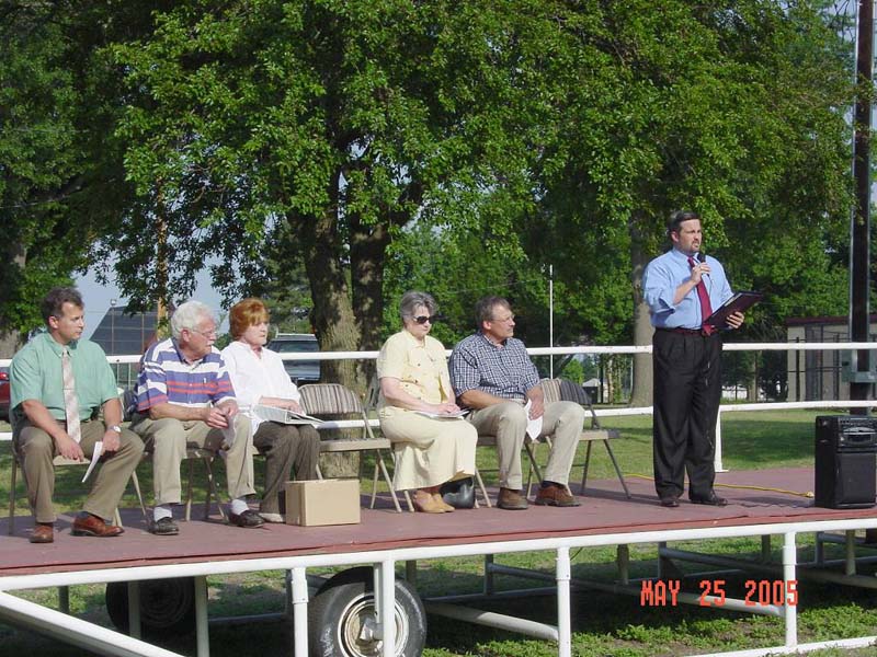
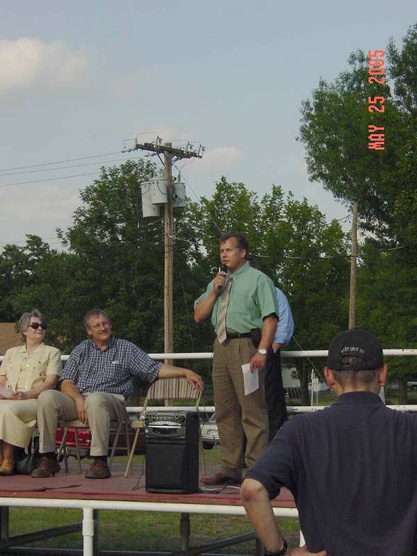
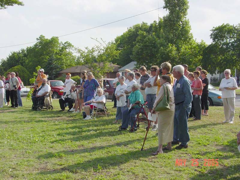
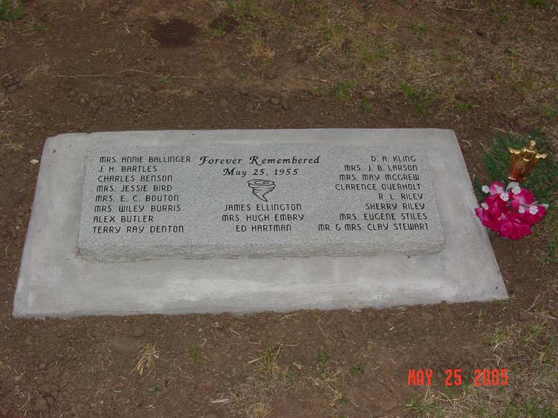
At 6 PM CDT on May 25, 2005, the 50th anniversary of the F5 Blackwell tornado, a dedication ceremony of the new Blackwell Tornado Memorial took place at Memorial Park in Blackwell. The Memorial Park is located at 1400 South Main in Blackwell, Oklahoma. Local community officials, tornado survivors, and relief workers were present during the ceremony. Two representatives from the NWS Norman forecast office were also in attendance.
Following the dedication, a reception took place at the Cherokee Strip Chapter of the American Red Cross in Blackwell. The reception gave the opportunity for Blackwell residents to visit with the tornado survivors, reminisce, and view the 1955 Tornado Book, which contains pictures, letters, stories and many other items of interest about this disaster. The Tornado Book will continue to be available for viewing for several months at the Blackwell Public Library. The Tornado Book is usually at the office of the Cherokee Strip Chapter, American Red Cross. Stories of survival and other historical items will continue to be added to the Tornado Book in the future.
 |
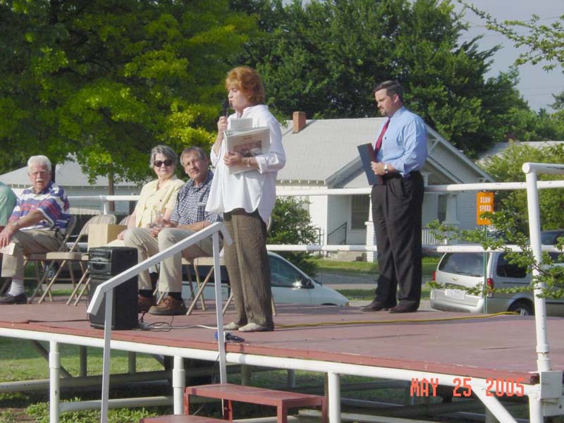 |
| Photo #1: Shane Frye, the Director of the Blackwell Chamber of Commerce, speaks during the dedication ceremony of the Blackwell Tornado Memorial on May 25, 2005. Shown in the photo from left to right are: Forrest Mitchell, NWS Norman; Mike Briggs, tornado survivor; Kathy Hawkins, Director of the Cherokee Strip Chapter of the Red Cross; Sally Norris, City Manager of Blackwell; Mark Cordell, Mayor of Blackwell; and Mr. Frye. Photo credit: NWS Norman. | Photo #2: Kathy Hawkins, Director of the Cherokee Strip Chapter of the Red Cross, speaks during the dedication ceremony of the Blackwell Tornado Memorial on May 25, 2005. Photo credit: NWS Norman. |
 |
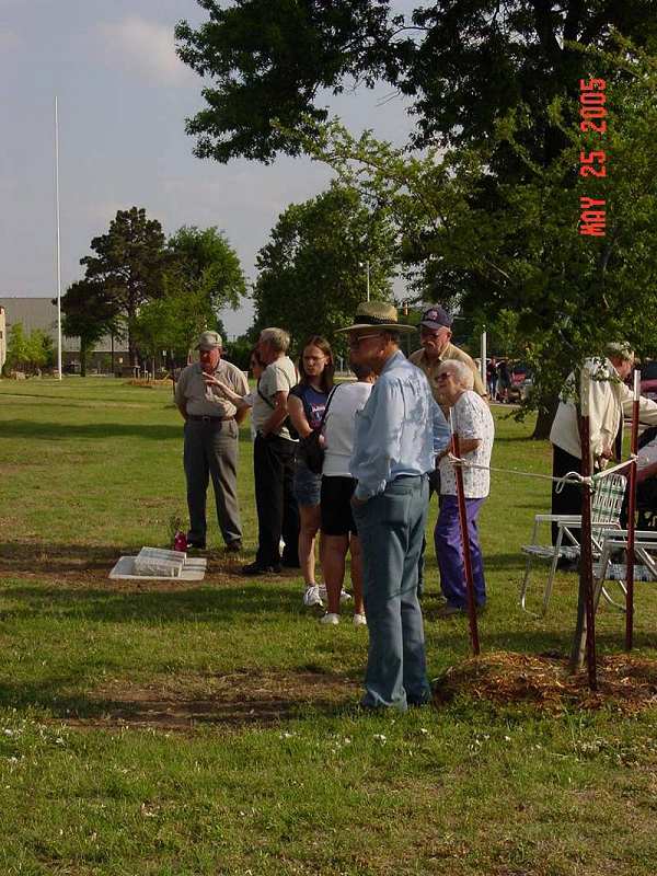 |
| Photo #3: Forrest Mitchell, Observation Program Leader at the NWS Norman forecast office, speaks during the dedication ceremony of the Blackwell Tornado Memorial on May 25, 2005. Photo credit: NWS Norman. | Photo #4: Photo of Blackwell residents and tornado survivors who attended the dedication ceremony of the Blackwell Tornado Memorial. The Blackwell Memorial is shown in the left-center of the photo. Photo credit: NWS Norman. |
 |
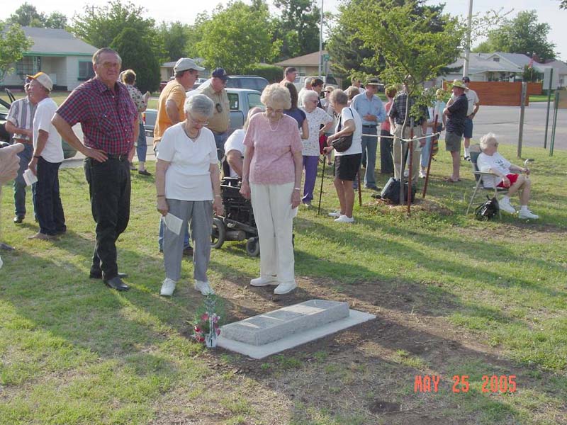 |
| Photo #5: Blackwell residents and tornado survivors view the Blackwell Tornado Memorial. Photo credit: NWS Norman. | Photo #6: Photo of Blackwell residents and tornado survivors who attended the dedication ceremony of the Blackwell Tornado Memorial. Photo credit: NWS Norman. |
 |
|
| Photo #7: Close-up view of the Blackwell Tornado Memorial. Photo credit: NWS Norman. |
[1] Blackwell Daily Journal, Blackwell OK, Thursday, May 26-28, 1955.