
From the Lower Mississippi into the Ohio Valley, widespread moderate to major river flooding will continue through midweek in response to last week’s extreme rainfall. Areas of standing inundation will be slow to recede. A fast-moving storm system crossing the Northeast U.S. through Tuesday will bring a few inches of snow and gusty winds making for hazardous travel conditions. Read More >
Last Map Update: Tue, Apr 8, 2025 at 7:00:20 am CDT

|
Local Weather History For April 8th...
|
|
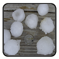
Damaging severe weather was seen across far northern Oklahoma on this
date back in 2011. Numerous supercell thunderstorms produced hail the size of golf balls to baseballs from Cherokee, eastward toward Medford, Billings, Enid, and Ponca City. A particularly strong supercell produced a measured 94 mph wind gust at the Ponca City airport. This resulted in significant damage to numerous buildings on and near the airport grounds. |
|
Text Product Selector (Selected product opens in current window)
|
|
 |
 |
 |
 |
 |
 |
| Observations | Discussion | Air Quality | Hydrology | FAQ | Social Media |
 |
 |
 |
 |
 |
 |
| Storm Reports | Gridded Forecast | Aviation | Climate | Storm Data | Weather Radio |
 |
 |
 |
 |
 |
 |
| Satellite | Hourly Forecast | Fire Weather | Past Events | StormReady | Storm Spotters |


 Local Radar
 Weather Map
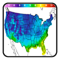
 Drought Conditions