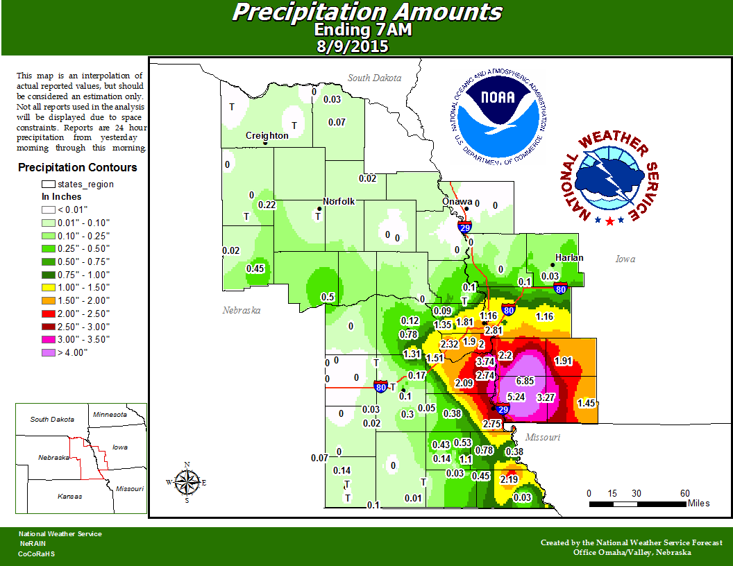
Heavy rain fell in parts of southeast Nebraska and southwest Iowa Sunday night. Totals in the 3 to 6 inch range were common.
SUPPLEMENTAL TEMPERATURE AND PRECIPITATION TABLE
NATIONAL WEATHER SERVICE OMAHA/VALLEY NEBRASKA
1000 AM CDT SUN AUG 9 2015

Values represent highs yesterday, low over the last 12 hours
and 24 hour precipitation ending at 7 am CDT.

Snow depth is measured daily and is valid as of 7 am CDT.

.BR OAX 0809 C DH01/TAIRZX/DH07/TAIRZP/PPDRZZ/SFDRZZ/SDIRZZ
:
:Eastern Nebraska and southwest Iowa
:Temperature and precipitation stations
:................................................................
:       Station             Max / Min  /  24 hr  /  Snow /  Snow
:        Name               Temp Temp  /  Pcpn   /  Fall /  Depth
:................................................................
:
:Eastern Nebraska
:
BVN  : Albion Airport      :  80 /  66  /  0.01   /    M /    M
BIE  : Beatrice Airport    :  86 /  72  /    T    /    M /    M
BTA  : Blair Airport       :  84 /  72  /    T    /    M /    M
OLU  : Columbus Airport    :  82 /  70  /  0.50   /    M /    M
FNB  : Falls City Arpt     :  86 /  71  /  0.03   /    M /    M
FET  : Fremont Airport     :  85 /  73  /    T    /    M /    M
LNK  : Lincoln Airport     :  88 /  74  /    T    /  0.0 /    0
AFK  : Nebraska City Arpt  :  84 /  70  /  2.75   /    M /    M
OFK  : Norfolk Airport     :  80 /  67  /    T    /  0.0 /    0
OFF  : Offutt AFB          :  86 /  70  /  2.12   /  0.0 /    0
OMA  : Omaha Eppley Field  :  87 /  73  /  1.16   /  0.0 /    0
MLE  : Omaha-Millard Arpt  :  85 /  73  /  1.45   /    M /    M
PMV  : Plattsmouth Arpt    :  84 /   M  /  2.74   /    M /    M
TQE  : Tekamah Airport     :  86 /  74  /  0.00   /    M /    M
OAXN1: Valley NWS          :  84 /  70  /  0.35   /  0.0 /    0
AHQ  : Wahoo Airport       :  84 /  73  /  0.12   /    M /    M
LCG  : Wayne Airport       :  81 /  66  /  0.02   /    M /    M
:
:Southwest Iowa
:
ICL  : Clarinda Airport    :  86 /  70  /     M   /    M /    M
CBF  : Council Bluffs      :  84 /  72  /  0.75   /    M /    M
HNR  : Harlan Airport      :  84 /  70  /  0.03   /    M /    M
RDK  : Red Oak Airport     :  86 /  70  /     M   /    M /    M
SDA  : Shenandoah Arpt     :  86 /   M  /     M   /    M /    M
:
.END

.BR OAX 0809 C DH07/TAIRZX/TAIRZN/PPDRZZ/SFDRZZ/SDIRZZ
:
:Eastern Nebraska and southwest Iowa Cooperative Weather Observer
:Temperature and Precipitation Reports

:Values are for the past 24 hours ending between 6 am and 8 am.
:.................................................................
:      Station           Report  Max / Min  / 24 hr  /  Snow / Snow
:       Name              Time   Temp  Temp /  Pcpn  /  Fall / Depth
:.................................................................
:
AUBN1:  Auburn          : DH0600/  85 /  67  /  0.69  /   0.0 /   0
AHLN1:  Ashland         : DH0510/  84 /  68  /  1.51  /   0.0 /   0
CTEN1:  Crete 4ESE      : DH0700/  85 /  68  /  0.02  /   0.0 /   0
DVDN1:  David City      : DH0600/  85 /  66  /  0.00  /     M /   M
ELGN1:  Elgin           : DH0830/  77 /  64  /    T   /   0.0 /   0
FCYN1:  Falls City 4NE  : DH0700/  86 /  69  /  0.01  /   0.0 /   0
FABN1:  Fairbury        : DH0700/  87 /  66  /    T   /   0.0 /   0
FCLN1:  Fort Calhoun 4W : DH0700/  83 /  66  /  0.02  /     M /   M
FMTN1:  Fremont         : DH0700/  86 /  68  /  0.00  /   0.0 /   0
FNDN1:  Friend 3E       : DH0700/  84 /  68  /  0.00  /   0.0 /   0
GRAN1:  Gretna          : DH0700/  85 /  68  /  1.52  /   0.0 /   0
HRTN1:  Hartington      : DH0700/  81 /  64  /  0.07  /     M /   M
OKDN1:  Oakdale         : DH0800/  78 /  65  /  0.22  /     M /   M
SEWN1:  Seward          : DH0700/  83 /  66  /  0.00  /   0.0 /   0
TBLN1:  Table Rock 4N   : DH0700/  86 /  68  /  0.22  /   0.0 /   0
TCMN1:  Tecumseh 1S     : DH0800/  86 /  68  /  0.07  /   0.0 /   0
VDLN1:  Verdel 6SSW     : DH0700/  80 /  64  /    T   /     M /   M
VRGN1:  Virginia 3SE    : DH0700/  85 /  68  /    T   /     M /   M
WPTN1:  West Point      : DH0800/  81 /  69  /  0.00  /   0.0 /   0
CSAI4:  Castana IA      : DH0725/  83 /  69  /  0.00  /     M /   M
CLDI4:  Clarinda IA     : DH0830/  86 /  69  /  1.45  /   0.0 /   0
GLNI4:  Glenwood IA     : DH0450/  85 /  67  /  2.20  /   0.0 /   0
LSXI4:  Little Sioux IA : DH0700/  85 /  70  /  0.00  /   0.0 /   0
LOGI4:  Logan IA        : DH0700/  85 /  69  /  0.00  /     M /   M
OAKI4:  Oakland IA      : DH0700/  85 /  68  /  1.16  /   0.0 /   M
ROKI4:  Red Oak IA      : DH0700/  87 /  70  /  1.91  /   0.0 /   0
SDHI4:  Shenandoah IA   : DH0800/  87 /  69  /  3.27  /     M /   M
SIDI4:  Sidney IA       : DH0630/  84 /  66  /  5.24  /   0.0 /   0
:
.END

.BR OAX 0809 C DH07/PPDRZZ/SFDRZZ/SDIRZZ
:
:Eastern Nebraska and southwest Iowa Cooperative Weather Observer
:24 hour precipitation - These stations report precipitation only.
:................................................................
:       Station                  Report    24 hr  /  Snow /  Snow
:        Name                     Time     Pcpn   /  Fall /  Depth
:................................................................
:
BRCN1:  Beatrice          :      DH0700/   0.00   /     M /    M
BNTN1:  Bennington        :      DH0900/   0.09   /   0.0 /    0
BLON1:  Bloomfield        :      DH0700/     T    /   0.0 /    0
LORN1:  Loretto           :      DH0700/   0.02   /     M /    M
MALN1:  Malcolm           :      DH0703/     T    /     M /    M
NLHN1:  Neligh            :      DH0700/   0.00   /     M /    M
OCDN1:  Orchard           :      DH0700/   0.00   /   0.0 /    0
PPLN1:  Papillion         :      DH0700/   1.18   /     M /    M
SBTN1:  Shubert           :      DH0700/   2.19   /   0.0 /    0
UTCN1:  Utica             :      DH0730/   0.00   /     M /    M
WSTN1:  Western           :      DH0800/   0.00   /     M /    M
KENI4:  Kennebec IA       :      DH0700/   0.00   /     M /    M
RANI4:  Randolph IA       :      DH0800/   6.85   /     M /    M
:
.END

These data are preliminary and have not undergone final quality
control by the National Centers for Environmental Information
(formerly known as NCDC). These data are subject to revision. Final
and certified climate data can be accessed at www.ncdc.noaa.gov.

