Severe storms, including large hail, wind, and perhaps a couple of tornadoes, are possible in the central Plains. Dry, windy conditions and lightning from dry thunderstorms may produce hazardous fire conditions in the Southwest and southern High Plains. Late-season snow is expected in the Northwest and the Great Basin. Heat is spreading across the eastern U.S.. Read More >
Overview
|
From the evening of May 20th through mid afternoon on May 21st, several waves of thunderstorms produced tornadoes, damaging winds with gusts up to 90 mph, hail up to tennis-ball size, and extremely heavy rainfall, which resulted in considerable flash flooding and river flooding. Six tornadoes (5 EF0 and 1 EF1) occurred with a fast-moving line of thunderstorms that moved through eastern Nebraska and southwest Iowa during the early morning hours on the 21st. An additional 4 tornadoes occurred with a second round of thunderstorms (supercells) that formed over far eastern Nebraska and tracked through southwest Iowa during the late morning and early afternoon hours on the 21st. |
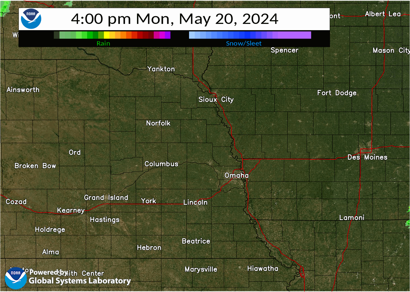 Radar loop from 4 PM on May 20th through 3 PM on May 21st |
Tornadoes
|
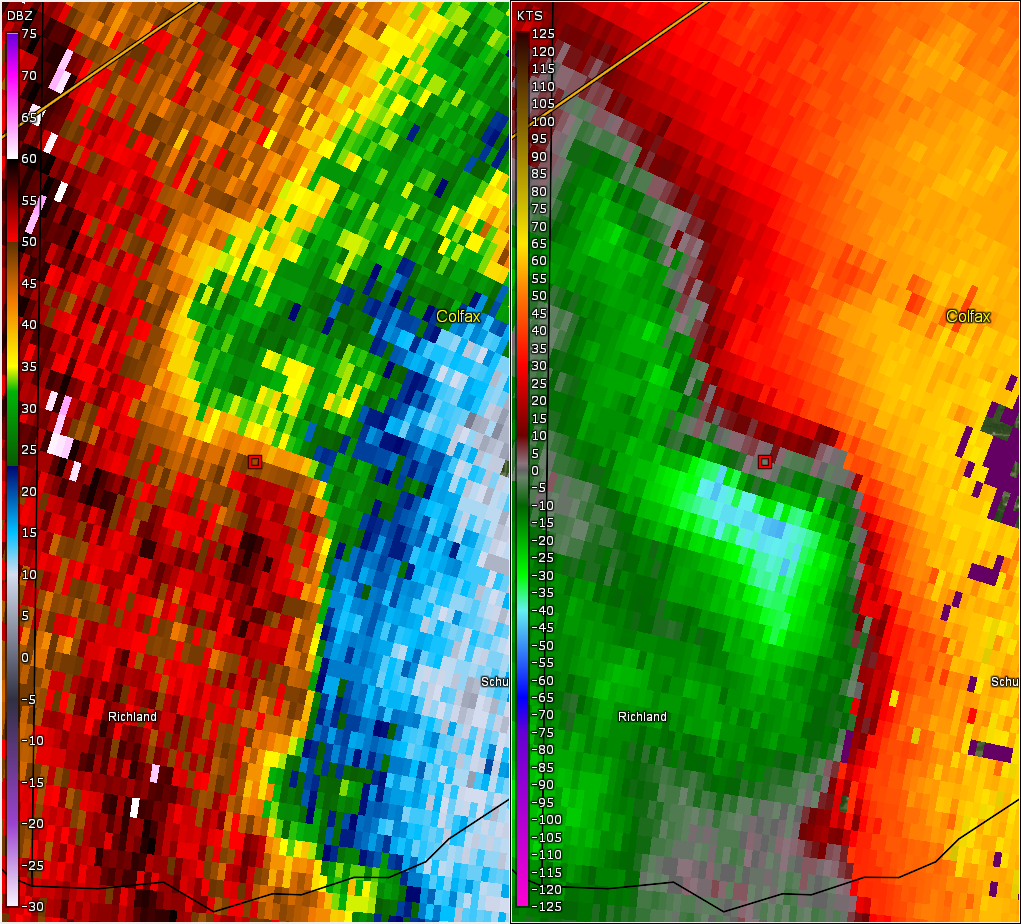
Tornado - Richland, NE Area
Track Map 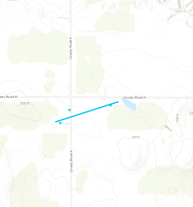 
Downloadable KMZ File |
||||||||||||||||
|
||||||||||||||||
|
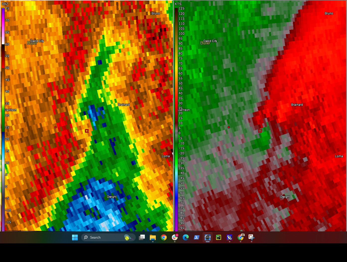
Tornado - Brainard, NE Area #1
Track Map 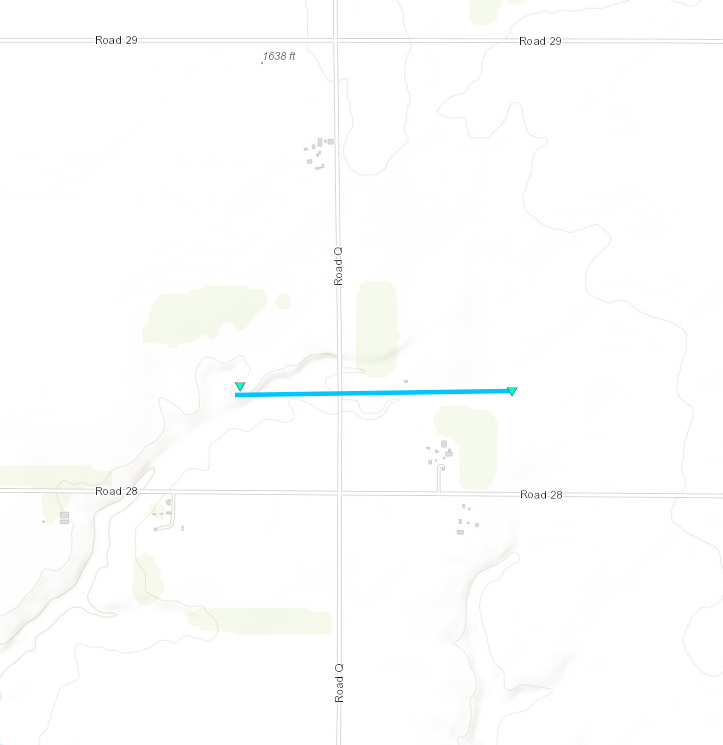
Downloadable KMZ File |
||||||||||||||||
|
||||||||||||||||
|
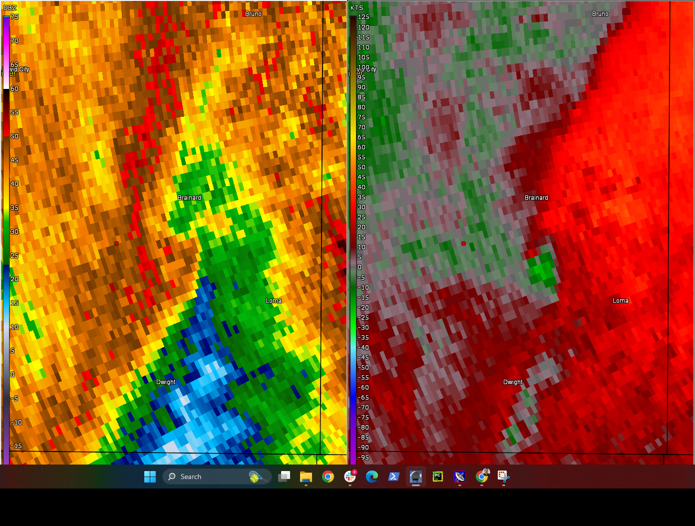
Tornado - Brainard, NE Area #2
Track Map 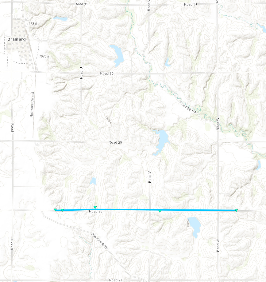
Downloadable KMZ File |
||||||||||||||||
|
||||||||||||||||
|
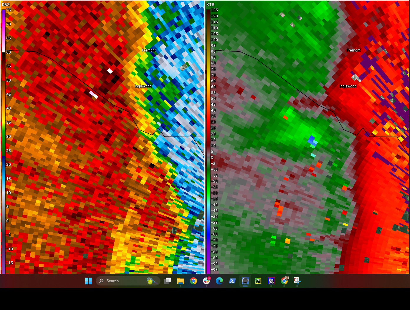
Tornado - Valley View
Track Map 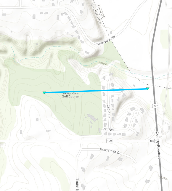
Downloadable KMZ File |
||||||||||||||||
|
||||||||||||||||
|
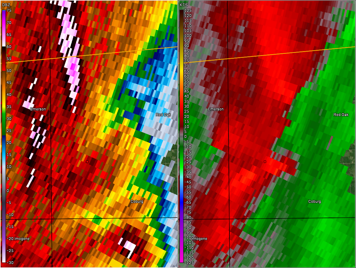
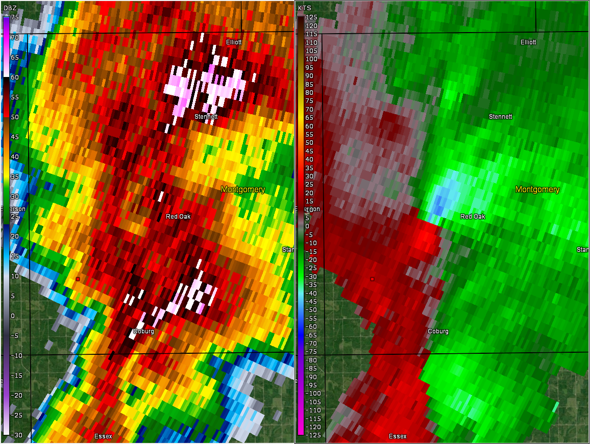
Tornado - Coburg, IA Area
Track Map 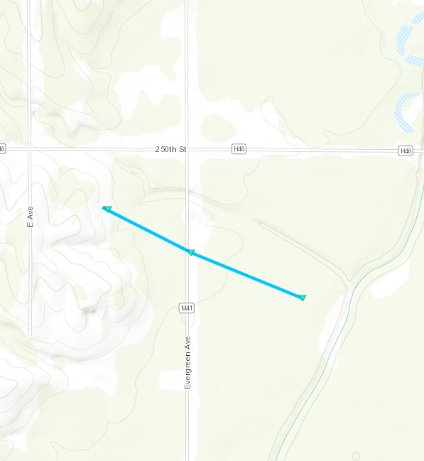
Downloadable KMZ File |
||||||||||||||||
|
||||||||||||||||
|
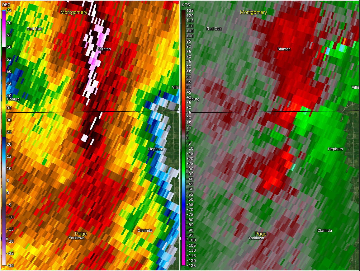
Tornado - Hepburn, IA Area
Track Map 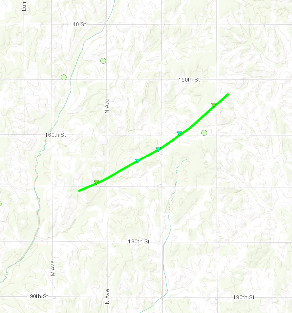
Downloadable KMZ File |
||||||||||||||||
|
||||||||||||||||
|
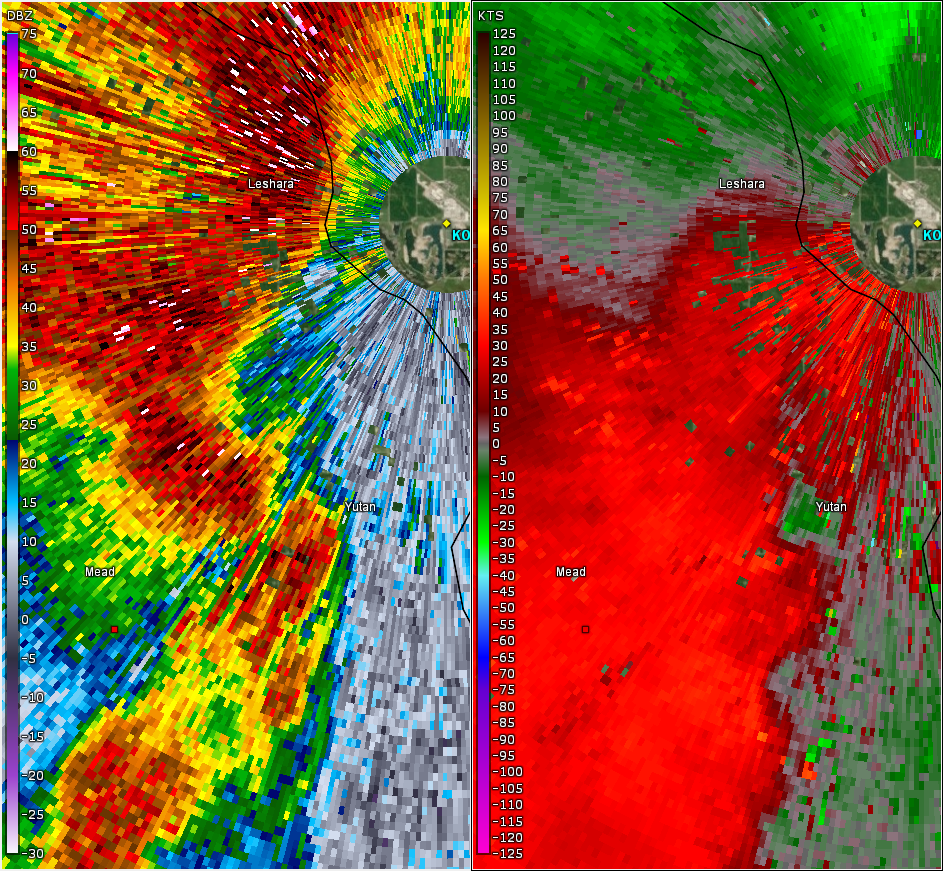
Tornado - Yutan, NE
Track Map 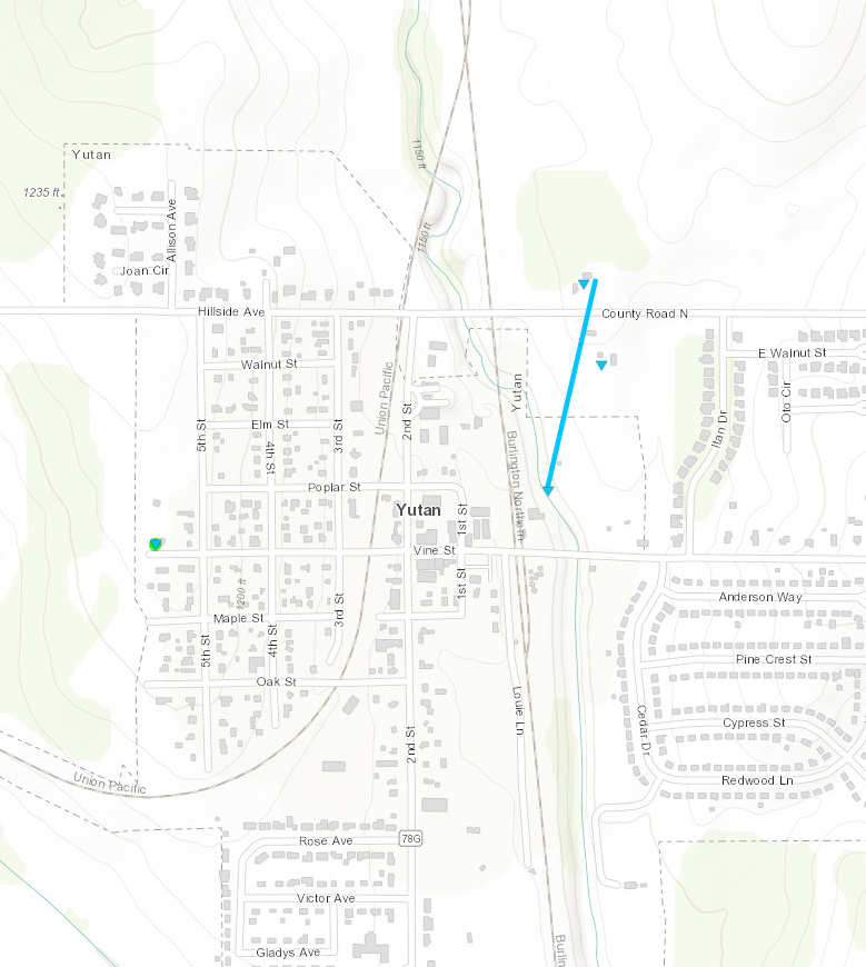
Downloadable KMZ File |
||||||||||||||||
|
||||||||||||||||
|
Tornado - Red Oak, IA
Track Map 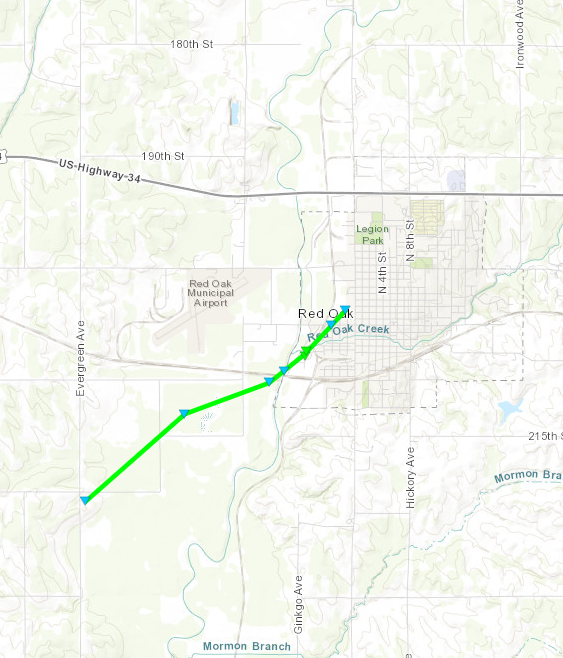
Downloadable KMZ File |
||||||||||||||||
|
||||||||||||||||
|
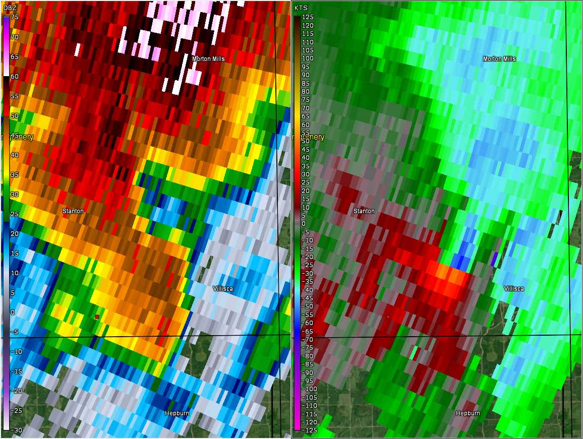
Tornado - Villisca-Carbon, IA
Track Map 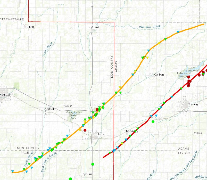
Downloadable KMZ File |
||||||||||||||||
|
||||||||||||||||
|
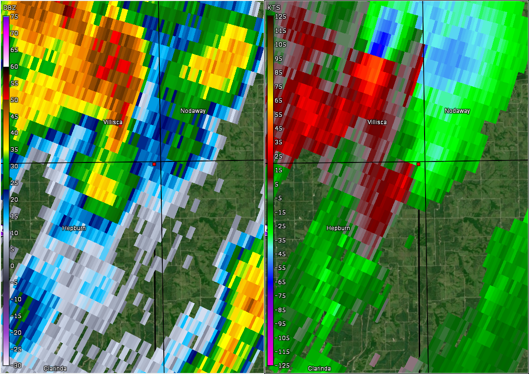
Tornado - Nodaway-Corning-Greenfield, IA
Track Map 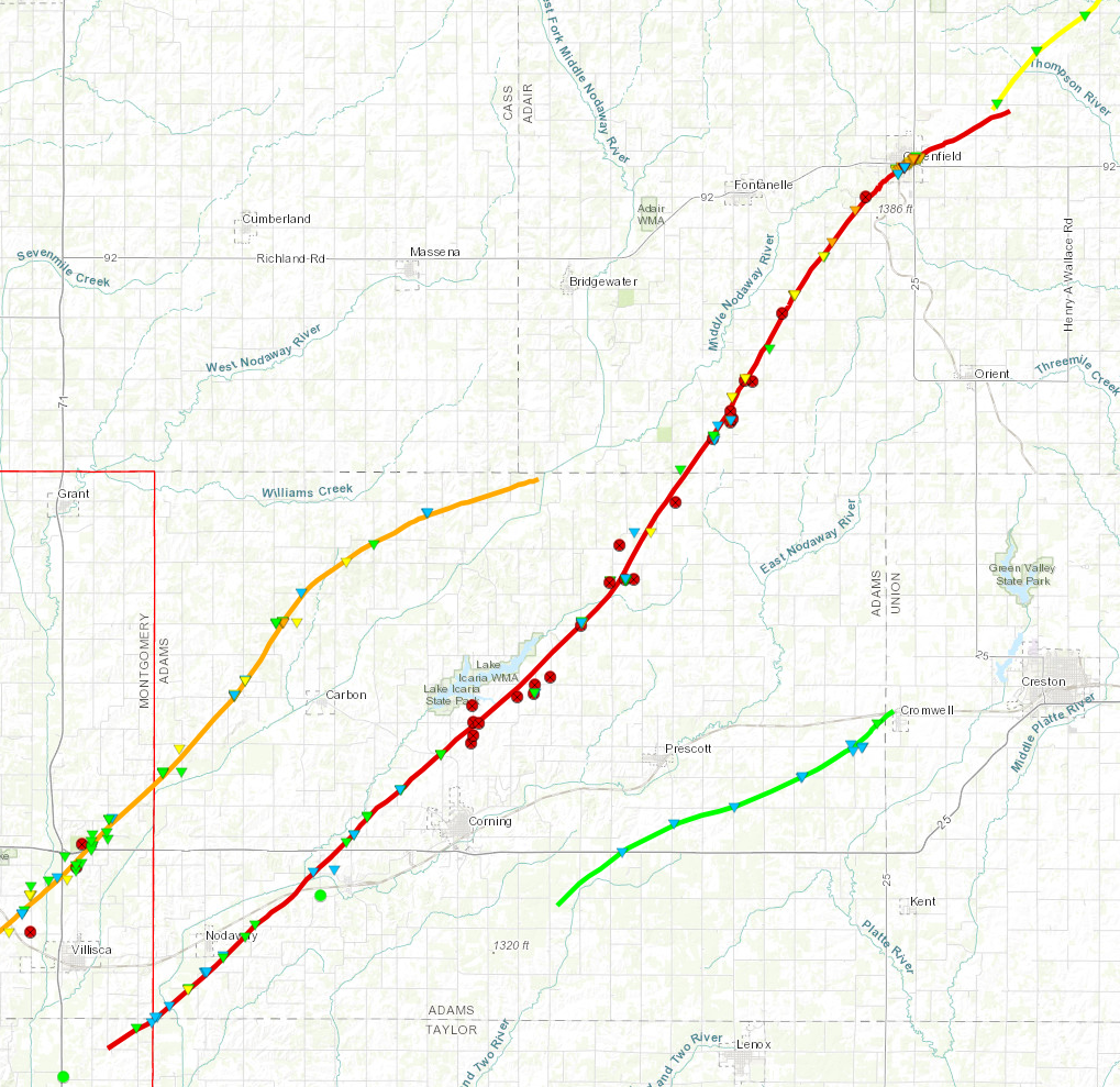
Downloadable KMZ File |
||||||||||||||||
|
||||||||||||||||
The Enhanced Fujita (EF) Scale classifies tornadoes into the following categories:
| EF0 Weak 65-85 mph |
EF1 Moderate 86-110 mph |
EF2 Significant 111-135 mph |
EF3 Severe 136-165 mph |
EF4 Extreme 166-200 mph |
EF5 Catastrophic 200+ mph |
 |
|||||
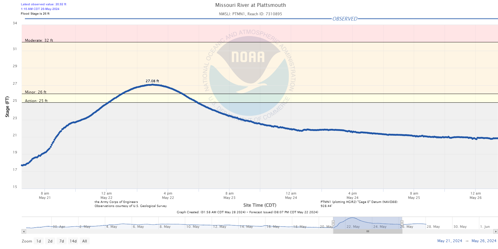
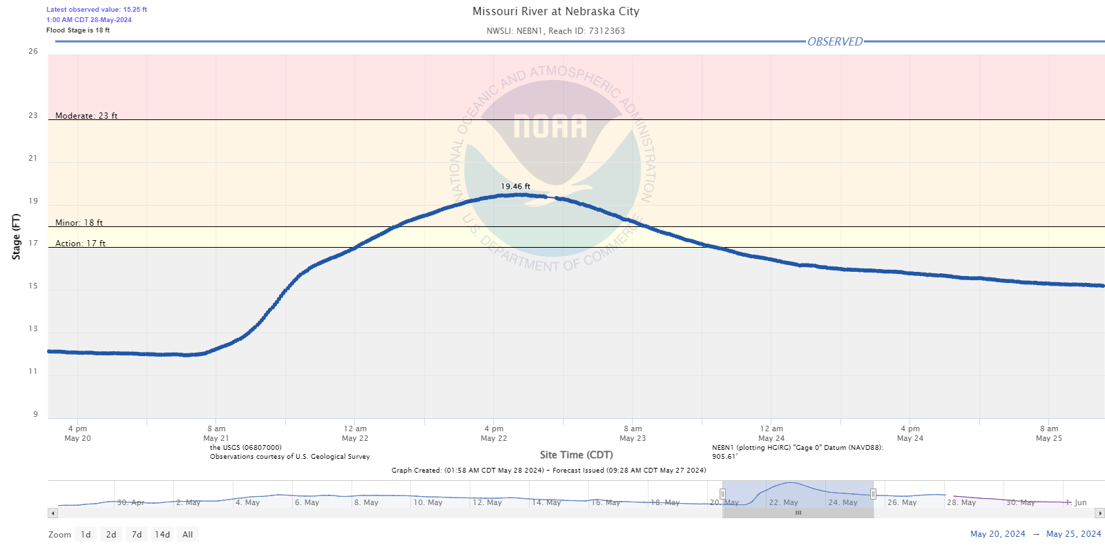
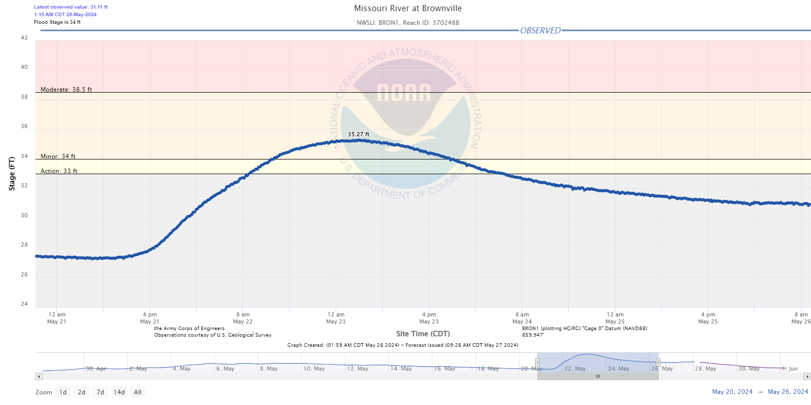
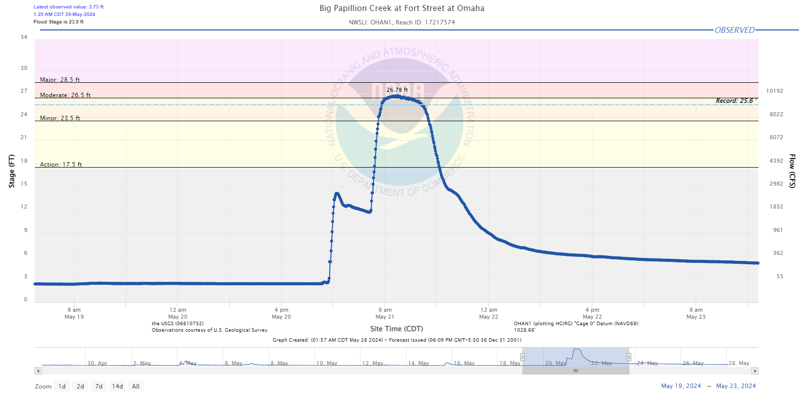
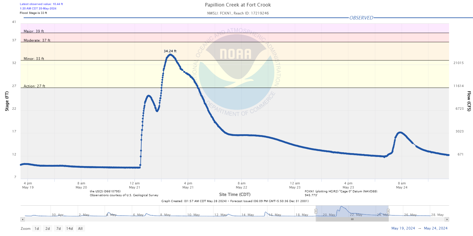
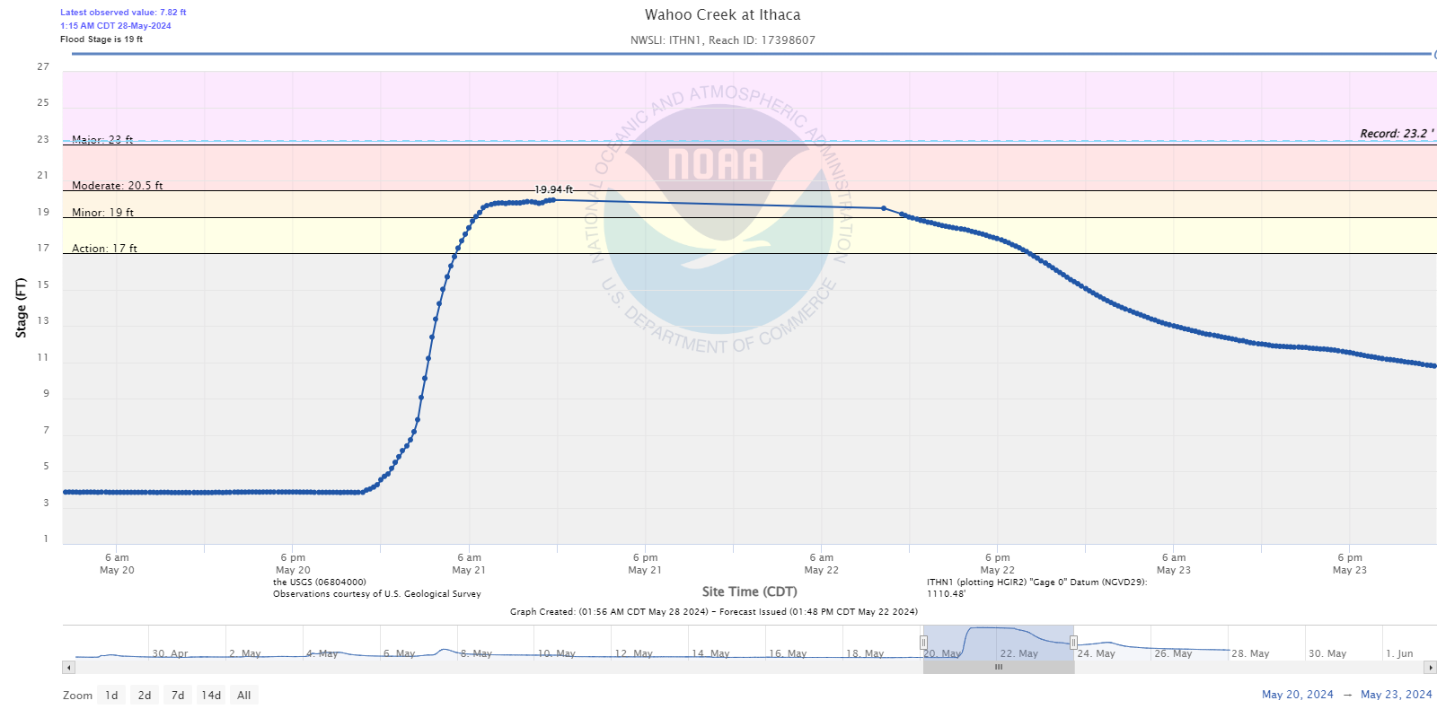
Flooding
Heavy rainfall led to flooding on some area rivers and creeks.
Hydrographs
 |
 |
 |
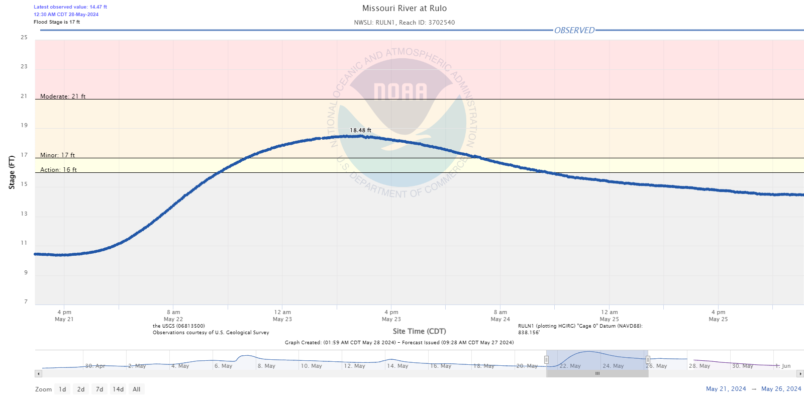 |
| Missouri River at Plattsmouth | Missouri River at Nebraska City | Missouri River at Brownville | Missouri River at Rulo |
 |
 |
 |
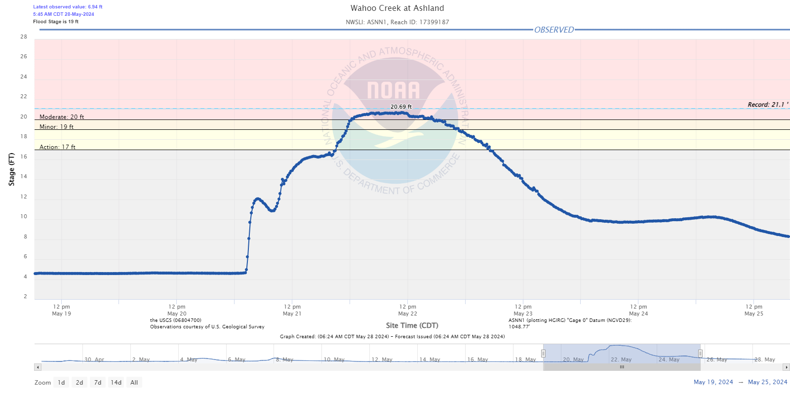 |
| Big Papillion Creek at Fort Street | Papillion Creek at Fort Crook | Wahoo Creek at Ithaca | Wahoo Creek at Ashland |
Storm Reports
..TIME... ...EVENT... ...CITY LOCATION... ...LAT.LON...
..DATE... ....MAG.... ..COUNTY LOCATION..ST.. ...SOURCE....
..REMARKS..
0800 PM Tstm Wnd Gst 3 SSE Valparaiso 41.04N 96.81W
05/20/2024 M54 MPH Lancaster NE Public
from personal weather station.
0845 PM Hail 1 N Bloomfield 42.62N 97.65W
05/20/2024 E1.25 Inch Knox NE Trained Spotter
0909 PM Hail Crofton 42.73N 97.50W
05/20/2024 M1.75 Inch Knox NE Public
Quarter to Golf ball sized hail.
0925 PM Hail Fordyce 42.70N 97.36W
05/20/2024 M1.25 Inch Cedar NE 911 Call Center
0928 PM Hail 2 NW Weston 41.21N 96.76W
05/20/2024 M1.75 Inch Saunders NE Public
0930 PM Hail 2 NW Hartington 42.64N 97.29W
05/20/2024 E1.75 Inch Cedar NE 911 Call Center
0941 PM Hail 1 S Malmo 41.25N 96.72W
05/20/2024 M1.00 Inch Saunders NE Public
0941 PM Hail 1 NNE Harlan 41.66N 95.32W
05/20/2024 M1.00 Inch Shelby IA Public
0949 PM Hail 3 N Harlan 41.69N 95.33W
05/20/2024 E2.00 Inch Shelby IA 911 Call Center
1007 PM Tstm Wnd Gst 2 NNW Decatur 42.03N 96.26W
05/20/2024 E65 MPH Burt NE Emergency Mngr
1026 PM Hail Valparaiso 41.08N 96.83W
05/20/2024 E1.25 Inch Saunders NE Public
Report from mPING: Half Dollar (1.25 in.).
1046 PM Hail 2 S Wahoo 41.19N 96.62W
05/20/2024 M0.25 Inch Saunders NE Public
1115 PM Tstm Wnd Gst 4 NE Bennington 41.42N 96.11W
05/20/2024 M69 MPH Washington NE ASOS
1120 PM Rain 2 S Wahoo 41.19N 96.62W
05/20/2024 M2.82 Inch Saunders NE Public
Corrects previous flash flood report from 2
S Wahoo. 2.82 inches of rain.
1138 PM Flash Flood 3 NW Boys Town 41.28N 96.18W
05/20/2024 Douglas NE Public
180th St just south of W Maple Rd completely
submerged, passage by vehicle is difficult.
1154 PM Flash Flood 1 SE Elkhorn 41.27N 96.23W
05/20/2024 Douglas NE Trained Spotter
Low lying roadways are water-covered . Water
is not up to the top of the gutters, but
some vehicles are having difficulty driving
through.
1218 AM Flash Flood Boys Town 41.26N 96.14W
05/21/2024 Douglas NE Dept of Highways
Ponding reported on eastbound Dodge Street
at 144th.
1239 AM Rain 4 SE Bennington 41.32N 96.11W
05/21/2024 M2.58 Inch Douglas NE Mesonet
Mesonet station CW8198 Bennington.
1250 AM Hail 2 N Minden 41.50N 95.54W
05/21/2024 M1.00 Inch Pottawattamie IA Trained Spotter
1252 AM Funnel Cloud 3 SW Harlan 41.62N 95.37W
05/21/2024 Shelby IA Public
Funnel Cloud 3 SW of Harlan near 900th and
Juniper Rd.
0116 AM Flash Flood 5 NE Omaha 41.32N 95.94W
05/21/2024 Douglas NE Public
2 cars stuck in the water.
0421 AM Rain Fremont 41.45N 96.49W
05/21/2024 M4.69 Inch Dodge NE Public
Several reports for heavy rainfall. Amounts
vary from 3.03 inches to 4.69 inches.
0454 AM Flash Flood Fremont 41.44N 96.49W
05/21/2024 Dodge NE Public
Fast flowing water over East 11st Street.
0505 AM Tstm Wnd Gst 2 NE Columbus 41.46N 97.33W
05/21/2024 M90 MPH Platte NE Emergency Mngr
Multiple power poles snapped off on the
northeast side of Columbus. Tree damage
around Columbus as well.
0514 AM Tstm Wnd Dmg 1 ENE Richland 41.44N 97.20W
05/21/2024 Colfax NE Emergency Mngr
Numerous outbuildings have roofs off
including a machine shed and 2 hog units.
Numerous overturned pivots. Time based on
radar.
0525 AM Tstm Wnd Dmg 3 SE Brainard 41.15N 96.96W
05/21/2024 Butler NE Trained Spotter
several tree tops snapped. Also 4.50
rainfall. Time estimated from radar.
0530 AM Hail 3 SW Bennington 41.33N 96.17W
05/21/2024 E1.75 Inch Douglas NE Public
Report from mPING of golfball sized hail 3
miles south-southwest of Bennington.
0530 AM Hail 4 NE Elkhorn 41.31N 96.18W
05/21/2024 E1.00 Inch Douglas NE Public
Report from mPING of quarter sized hail 4
miles northeast of Elkhorn.
0530 AM Tstm Wnd Gst Howells 41.72N 97.00W
05/21/2024 M79 MPH Colfax NE Trained Spotter
0533 AM Hail 1 NW Bennington 41.37N 96.17W
05/21/2024 E1.00 Inch Douglas NE Public
Report from mPING of quarter sized hail on
the northwest side of Bennington.
0533 AM Tstm Wnd Dmg 1 S Snyder 41.68N 96.79W
05/21/2024 Dodge NE Emergency Mngr
6 power poles down. Time based on radar.
0536 AM Hail 3 WNW Boys Town 41.28N 96.18W
05/21/2024 E1.00 Inch Douglas NE Public
0536 AM Hail 3 SE Bennington 41.33N 96.14W
05/21/2024 E1.00 Inch Douglas NE Public
Report from mPING of quarter sized hail
southeast of Bennington.
0537 AM Hail Bennington 41.37N 96.15W
05/21/2024 M1.50 Inch Douglas NE Public
0539 AM Tstm Wnd Dmg 1 NW Winside 42.19N 97.19W
05/21/2024 Wayne NE Emergency Mngr
Numerous outbuildings damaged. Trees
uprooted and powerlines down. Time based on
radar.
0540 AM Hail 2 SE Elkhorn 41.26N 96.21W
05/21/2024 E1.00 Inch Douglas NE Public
0542 AM Hail 3 SSW Bennington 41.32N 96.18W
05/21/2024 E1.25 Inch Douglas NE Public
0545 AM Tstm Wnd Dmg 1 SSW Inglewood 41.40N 96.51W
05/21/2024 Saunders NE NWS Employee
Numerous large trees down across Valley View
Estates and Valley View Golf Course. Delayed
report.
0602 AM Hail 2 W Omaha 41.26N 96.05W
05/21/2024 E1.00 Inch Douglas NE Public
0606 AM Hail 3 N Council Bluffs 41.28N 95.86W
05/21/2024 E1.75 Inch Pottawattamie IA Amateur Radio
0607 AM Tstm Wnd Gst 3 ESE Tekamah 41.76N 96.18W
05/21/2024 M62 MPH Burt NE ASOS
0612 AM Hail 2 N Council Bluffs 41.27N 95.87W
05/21/2024 E1.25 Inch Pottawattamie IA Public
0615 AM Rain 2 NW Valley 41.34N 96.37W
05/21/2024 M4.78 Inch Douglas NE Amateur Radio
0619 AM Tstm Wnd Gst 1 WSW Omaha 41.26N 96.02W
05/21/2024 M60 MPH Douglas NE Broadcast Media
0623 AM Flash Flood 2 NNE Boys Town 41.29N 96.12W
05/21/2024 Douglas NE Public
0624 AM Hail 1 WSW Omaha 41.26N 96.02W
05/21/2024 M1.00 Inch Douglas NE Broadcast Media
0625 AM Flash Flood 2 SE Boys Town 41.23N 96.10W
05/21/2024 Douglas NE Public
Water over the road.
0639 AM Rain 1 W Omaha 41.26N 96.02W
05/21/2024 M3.00 Inch Douglas NE Broadcast Media
3 inches of rain in 45 minutes at 72nd and
Dodge.
0654 AM Rain Bennington 41.36N 96.15W
05/21/2024 M6.17 Inch Douglas NE NWS Employee
0700 AM Flash Flood 1 SE Leshara 41.32N 96.42W
05/21/2024 Saunders NE Emergency Mngr
6 homes flooded. 4 homes evacuated. Time
estimated from early morning thunderstorms.
0702 AM Flash Flood 1 NNW Mead 41.25N 96.50W
05/21/2024 Saunders NE NWS Employee
Water flowing over Highway 77.
0707 AM Rain 4 NNE Boys Town 41.31N 96.11W
05/21/2024 M5.18 Inch Douglas NE NWS Employee
quarter size hail from earlier.
0712 AM Flash Flood Minden 41.47N 95.54W
05/21/2024 Pottawattamie IA Emergency Mngr
Street flooding in Minden. Sewer system
completely inundated and water over roads at
340th St between southeast Minden and Keg
Creek Bridge area.
0721 AM Rain 3 ENE Omaha 41.28N 95.96W
05/21/2024 M4.37 Inch Douglas NE NWS Employee
35th and Charles.
0742 AM Flash Flood Bruno 41.28N 96.95W
05/21/2024 Butler NE Emergency Mngr
Many roads underwater, especially in the
Skull Creek area.
0757 AM Rain 2 WNW Omaha 41.28N 96.04W
05/21/2024 M6.37 Inch Douglas NE Public
0834 AM Flood 2 S Omaha 41.24N 96.01W
05/21/2024 Douglas NE Broadcast Media
Media reports flooding with multiple stalled
vehicles at Center and 67th Street.
1215 PM Hail Malmo 41.27N 96.72W
05/21/2024 M1.25 Inch Saunders NE Public
1221 PM Hail 1 N Colon 41.31N 96.60W
05/21/2024 M1.00 Inch Saunders NE Public
Report from mPING: Quarter (1.00 in.).
1229 PM Hail 1 SSW Inglewood 41.40N 96.51W
05/21/2024 M1.75 Inch Saunders NE NWS Employee
1231 PM Hail 2 W Inglewood 41.41N 96.54W
05/21/2024 E1.75 Inch Saunders NE Public
Report from mPING: Golf Ball (1.75 in.).
1232 PM Hail 1 NNW Fremont 41.45N 96.50W
05/21/2024 E1.75 Inch Dodge NE Public
1234 PM Hail 1 NW Fremont 41.45N 96.50W
05/21/2024 E1.75 Inch Dodge NE Public
Report from mPING: Golf Ball (1.75 in.).
1239 PM Hail Fremont 41.44N 96.49W
05/21/2024 E1.75 Inch Dodge NE Public
Report from mPING: Golf Ball (1.75 in.).
1240 PM Tstm Wnd Gst 1 NNW Fremont 41.45N 96.50W
05/21/2024 E65 MPH Dodge NE Trained Spotter
1244 PM Hail 2 NW Fremont 41.45N 96.52W
05/21/2024 E1.75 Inch Dodge NE Public
Report from mPING: Golf Ball (1.75 in.).
1257 PM Funnel Cloud 3 E Yutan 41.25N 96.33W
05/21/2024 Douglas NE Law Enforcement
Video confirms funnel cloud did not touch
down.
0115 PM Flash Flood 4 N Valley 41.37N 96.35W
05/21/2024 Douglas NE Law Enforcement
276th street closed north of Valley from
Highway 275 to Highway 36. Highway 36 is
closed at the intersection of 276th street.
0125 PM Hail Syracuse 40.66N 96.19W
05/21/2024 E1.25 Inch Otoe NE Public
Report from mPING: Half Dollar (1.25 in.).
0128 PM Hail Blencoe 41.93N 96.09W
05/21/2024 E1.00 Inch Monona IA Public
Report from mPING: Quarter (1.00 in.).
0130 PM Hail 2 W Ralston 41.21N 96.08W
05/21/2024 E1.00 Inch Douglas NE Public
Report from mPING: Quarter (1.00 in.).
0135 PM Tstm Wnd Dmg La Vista 41.18N 96.04W
05/21/2024 Sarpy NE Public
Report from mPING: 1-inch tree limbs broken;
Shingles blown off.
0137 PM Tstm Wnd Dmg 5 E Bennington 41.37N 96.06W
05/21/2024 Douglas NE Public
Trees reported down.
0138 PM Hail 3 SSW Nehawka 40.80N 96.02W
05/21/2024 E2.50 Inch Cass NE Trained Spotter
Emergency Manager relayed a report from a
trained spotter of tennis ball sized hail at
67th and A street.
0143 PM Funnel Cloud 2 NE Union 40.83N 95.89W
05/21/2024 Cass NE Trained Spotter
Trained Spotter reported a funnel cloud to
the west of Thurman. Funnel has since gone
up but strong rotation persists.
0212 PM Hail Imogene 40.87N 95.43W
05/21/2024 M1.00 Inch Fremont IA Public
Report from mPING: Quarter (1.00 in.).
0216 PM Hail 2 NE Emerson 41.03N 95.38W
05/21/2024 E1.00 Inch Montgomery IA Public
Report from mPING: Quarter (1.00 in.).
0216 PM Funnel Cloud 3 SSE Imogene 40.84N 95.42W
05/21/2024 Fremont IA Broadcast Media
Funnel cloud reported by broadcast media
extending halfway to the ground. This was
just south of Imogene.
0225 PM Funnel Cloud 3 ENE Imogene 40.89N 95.37W
05/21/2024 Page IA Trained Spotter
Trained spotter reported a funnel cloud and
rotation in the far northwest corner of Page
County.
0232 PM Hail 4 W Red Oak 41.03N 95.31W
05/21/2024 M1.25 Inch Montgomery IA Public
Report from mPING: Half Dollar (1.25 in.).
0233 PM Funnel Cloud 5 ESE Emerson 40.98N 95.32W
05/21/2024 Montgomery IA Emergency Mngr
Emergency Manager reported another funnel
developing to the southwest of Red Oak.
0237 PM Tornado 2 W Red Oak 41.01N 95.27W
05/21/2024 Montgomery IA Emergency Mngr
Tornado on the ground near the Red Oak
airport. Reported by the Emergency Manager.
0248 PM Funnel Cloud 4 W Hepburn 40.85N 95.09W
05/21/2024 Page IA Broadcast Media
Media reported large funnel 4 miles west of
Hepburn.
0300 PM Tornado 3 N Villisca 40.98N 94.97W
05/21/2024 Montgomery IA Broadcast Media
Live video of a confirmed tornado crossing
Highway 34 just east of Highway 71.
&&
Rain Reports
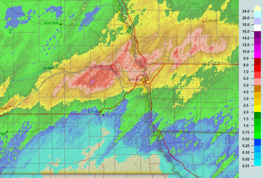 During the nighttime hours of May 20th into the morning hours of the 21st, a swath of heavy rain fell from Butler County east-northeast through Saunders, Dodge, Washington, Douglas, Harrison, Pottawattamie, and Shelby Counties. Rainfall in excess of 6-7" was measured at several locations, leading to flash flooding and some river and creek flooding. |
...48-HOUR PRECIPITATION REPORTS...

Location                     Amount    Time/Date       Provider

...Iowa...

...Fremont County...
0.8 W Randolph               0.69 in   0200 AM 05/22   HADS

...Harrison County...
5 WNW Persia                 5.04 in   0931 PM 05/21
Desoto                       4.60 in   0145 AM 05/22   RAWS
Loess Hills State Forest     3.43 in   0111 AM 05/22   RAWS
Logan                        2.44 in   0200 AM 05/22   HADS
Pisgah                       1.65 in   0200 AM 05/22   HADS

...Mills County...
1 S Malvern                  1.25 in   0700 AM 05/21

...Monona County...
2 SSW Blencoe                2.66 in   0200 AM 05/22   AWS
4.1 SW Turin                 1.62 in   0200 AM 05/22   HADS
3.9 S Turin                  1.36 in   0200 AM 05/22   HADS
CASTANA                      1.22 in   0155 AM 05/22   CWOP
ONAWA                        1.14 in   0155 AM 05/22   CWOP
1.2 SW Mapleton              1.05 in   0200 AM 05/22   HADS
Decatur                      0.58 in   0200 AM 05/22   HADS

...Montgomery County...
6 NE Emerson                 1.78 in   0200 AM 05/22   AWS
0.9 W Red Oak                1.34 in   0200 AM 05/22   HADS
2 NNW Coburg                 1.20 in   0155 AM 05/22   AWS

...Page County...
3.0 E Clarinda               0.55 in   0145 AM 05/22   HADS

...Pottawattamie County...
2 NE Council Bluffs          3.98 in   0200 AM 05/22   AWS
Carter Lake                  3.05 in   0200 AM 05/22   CWOP
Underwood                    2.47 in   0200 AM 05/22   CWOP
Loess Hills Hitchcock        2.30 in   0111 AM 05/22   RAWS

...Nebraska...

...Antelope County...
Ewing 5ESE                   1.46 in   0200 AM 05/22   CWOP
Neligh                       0.86 in   0135 AM 05/22   CWOP

...Boone County...
6 NNE Belgrade               0.79 in   0200 AM 05/22   AWS
Cedar Rapids                 0.72 in   0158 AM 05/22   CWOP
Albion Airport               0.69 in   0155 AM 05/22   AWOS

...Burt County...
Tekamah Airport              3.89 in   0154 AM 05/22   ASOS

...Cass County...
Plattsmouth                  1.31 in   0200 AM 05/22   CWOP
Plattsmouth                  0.84 in   0156 AM 05/22   CWOP
Plattsmouth Airport          0.55 in   0155 AM 05/22   AWOS

...Cedar County...
3 NE Randolph                1.14 in   0200 AM 05/22   AWS

...Dodge County...
1 N Fremont                  6.22 in   0726 AM 05/21
Fremont Airport              5.65 in   0155 AM 05/22   AWOS
Fremont                      4.69 in   0421 AM 05/21   Public

...Douglas County...
1.6 NW Bennington            7.48 in   0200 AM 05/22   HADS
Omaha 2.5 W                  6.86 in   0530 PM 05/21   COCORAHS
2 WNW Omaha                  6.37 in   0757 AM 05/21   Public
Bennington                   6.17 in   0654 AM 05/21   NWS Employee
1.7 N Chalco                 5.32 in   0200 AM 05/22   HADS
3 SE Bennington              5.19 in   0200 AM 05/22   AWS
4 NNE Boys Town              5.18 in   0707 AM 05/21   NWS Employee
1 SSE Elkhorn                5.15 in   1006 PM 05/21
3 ENE Elkhorn                5.00 in   0740 AM 05/21
1 E Omaha                    4.93 in   0700 AM 05/21
2 NW Valley                  4.78 in   0615 AM 05/21   Amateur Radio
3.7 NW Omaha                 4.68 in   0150 AM 05/22   HADS
3 ENE Omaha                  4.37 in   0721 AM 05/21   NWS Employee
1.1 E Ralston                4.16 in   0200 AM 05/22   ALERT
2 SSE Omaha                  3.92 in   0734 PM 05/21
Omaha                        3.59 in   0156 AM 05/22   CWOP
Valley 1 WNW                 3.55 in   1200 AM 05/22   COOP
3.6 NE Boys Town             3.36 in   0120 AM 05/22   HADS
4 SE Bennington              3.26 in   0710 AM 05/21
Millard                      3.16 in   0200 AM 05/22   AWS
0.8 SE Boys Town             3.08 in   0145 AM 05/22   HADS
1.4 SW Omaha                 3.04 in   0145 AM 05/22   HADS
1 W Omaha                    3.00 in   0639 AM 05/21   Broadcast Media
2.8 E Boys Town              3.00 in   0135 AM 05/22   ALERT
3.9 N Boys Town              2.87 in   0115 AM 05/22   HADS
Omaha                        2.75 in   0200 AM 05/22   CWOP
Bennington                   2.71 in   0145 AM 05/22   CWOP
Omaha Eppley Airfield        2.66 in   0152 AM 05/22   ASOS
2.1 S Carter Lake            2.52 in   0200 AM 05/22   HADS
2.1 W Boys Town              2.20 in   0150 AM 05/22   HADS
Omaha                        2.15 in   0200 AM 05/22   CWOP
3.1 E Ralston                2.12 in   0125 AM 05/22   HADS
Millard Airport              1.72 in   0155 AM 05/22   AWOS
0.9 N Millard                0.70 in   0115 AM 05/22   HADS
1.5 NW Omaha                 0.68 in   0105 AM 05/22   HADS

...Madison County...
Norfolk                      0.60 in   0200 AM 05/22   CWOP
Norfolk Airport              0.52 in   0156 AM 05/22   ASOS

...Platte County...
2.5 NE Columbus              2.00 in   1200 AM 05/22   COOP
Columbus                     1.42 in   0157 AM 05/22   CWOP
Duncan                       1.28 in   0200 AM 05/22   CWOP
Columbus                     0.58 in   0145 AM 05/22   CWOP

...Sarpy County...
Bellevue                     2.20 in   0155 AM 05/22   CWOP
La Vista                     2.17 in   0153 AM 05/22   CWOP
1.1 W Offutt Afb             1.64 in   0120 AM 05/22   HADS
1.1 SW Chalco                1.61 in   0115 AM 05/22   HADS
Springfield                  0.58 in   0145 AM 05/22   CWOP

...Saunders County...
1 S Wahoo                    5.90 in   0756 AM 05/21
Wahoo                        2.55 in   0155 AM 05/22   AWOS
ASHLAND                      1.40 in   0156 AM 05/22   CWOP
3 SSE Mead                   1.09 in   0200 AM 05/22   AWS
Valparaiso 6NW               0.58 in   0200 AM 05/22   NE-MESO

...Seward County...
Utica                        0.98 in   0200 AM 05/22   AWS

...Stanton County...
STANTON                      0.95 in   0200 AM 05/22   CWOP

...Washington County...
1.7 SE Kennard               7.88 in   0200 AM 05/22   ALERT
Blair 6.3 S                  6.28 in   0254 PM 05/21   COCORAHS
5.1 W Blair                  3.92 in   0110 AM 05/22   HADS
Missouri River               3.41 in   0200 AM 05/22   HADS
Blair                        3.40 in   0200 AM 05/22   CWOP
Blair Muni                   3.28 in   0155 AM 05/22   AWOS
2.4 N Kennard                2.91 in   0115 AM 05/22   HADS
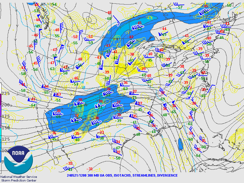
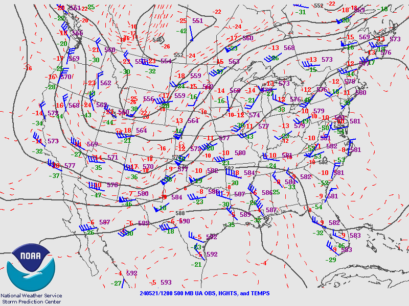
Environment
Insert synoptic summary.
 |
 |
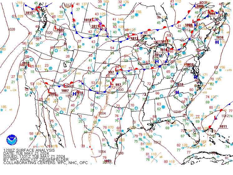 |
| Figure 1: 300-mb analysis at 7 AM on May 21st | Figure 2: 500-mb analysis at 7 AM on May 21st | Figure 3: Surface analysis at 7 AM on May 21st |
Near-storm environment summary.
 |
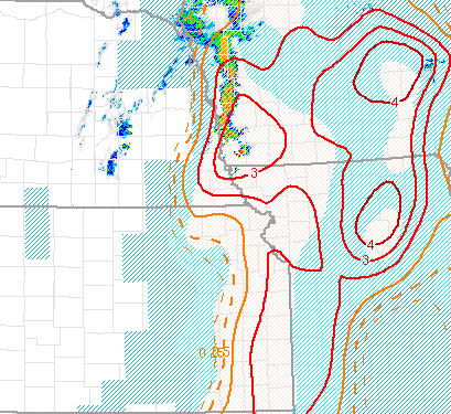 |
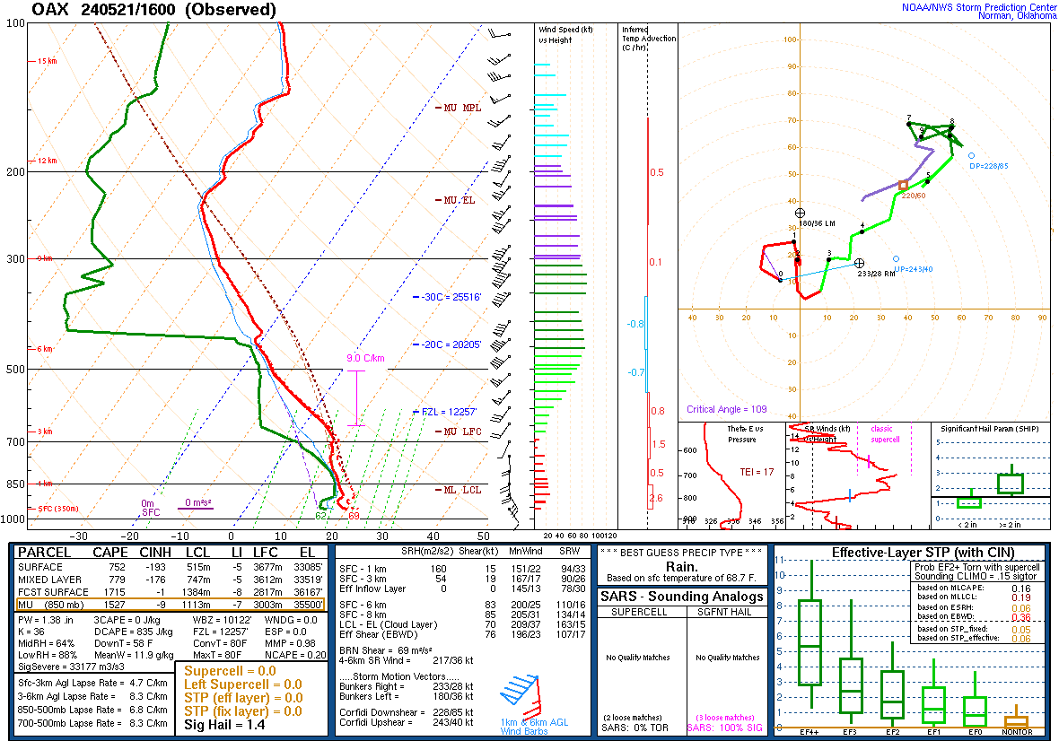
|
| Figure 4: Observed sounding at Valley, NE at 11 AM on May 21st. | Figure 5: Significant tornado parameter (effective layer) at 2 PM on May 21st. |
Additional Information
The Forecast
 |
 |
| SPC Day 7 Probabilistic Outlook | SPC Day 6 Probabilistic Outlook |
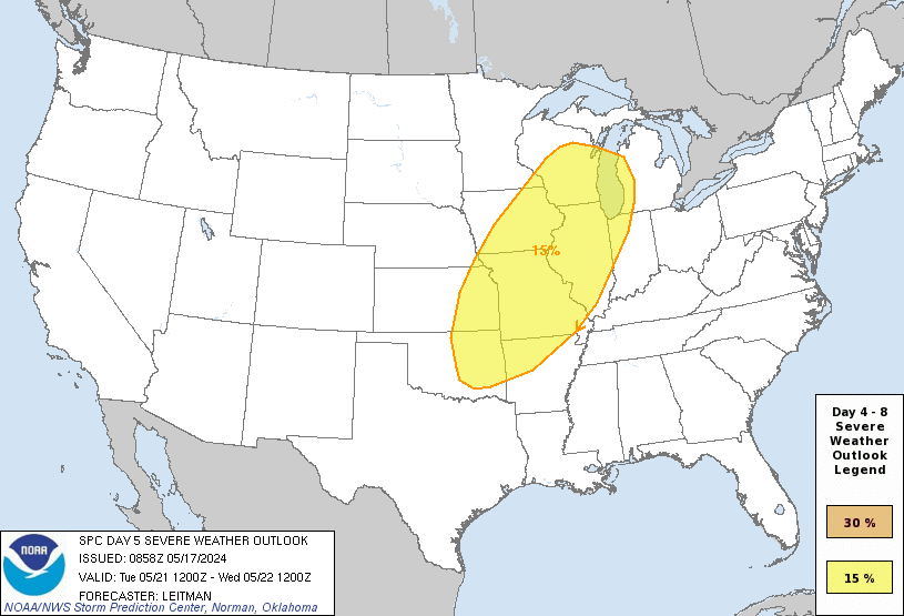 |
 |
| SPC Day 5 Probabilistic Outlook | SPC Day 4 Probabilistic Outlook |
 |
 |
| SPC Day 3 Categorical Outlook | SPC Day 3 Probabilistic Outlook |
 |
 |
 |
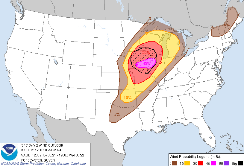 |
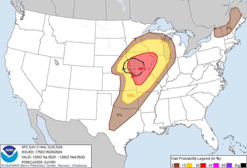
| SPC Day 2 Categorical Outlook | SPC Day 2 Tornado Outlook | SPC Day 2 Hail Outlook | SPC Day 2 Wind Outlook |
 |
 |
 |
 |
| SPC Day 1 Categorical Outlook | SPC Day 1 Tornado Outlook | SPC Day 1 Hail Outlook | SPC Day 1 Wind Outlook |
Summaries from other NWS Offices
 |
Media use of NWS Web News Stories is encouraged! Please acknowledge the NWS as the source of any news information accessed from this site. |
|