Top Weather Events of 2023
Here is a look back at some of the notable weather events that occurred in eastern Nebraska and southwest Iowa in 2023. Below the events are climate records and other facts from the year.
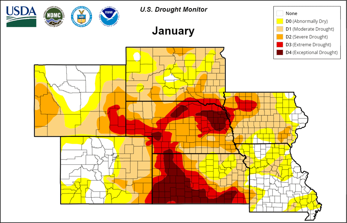
The Drought Continues
The drought that started in 2021 continued into 2023. The year began with 47% of the NWS Omaha service area in Extreme (D3) or Exceptional Drought (D4) classification. Snowfall and precipitation were below normal over the winter except for in northeast Nebraska. The spring was exceptionally dry with Norfolk observing its driest spring on record with only 2.41” of precipitation. Omaha and Lincoln observed their 16th and 3rd driest spring respectively. May was particularly dry for Omaha with only 0.17” of precipitation, the driest May on record. There was improvement to the drought conditions over the summer as rainfall was close to normal in June, July, and August. Conditions vastly improved in western Nebraska where rainfall was well above the climatic normal. For the state of Nebraska, the percentage of area under a drought classification was reduced from 100% to 69% after the summer rain. Areas in the highest two categories (D3 or D4) were reduced from 46% to 13%. This was further reduced after a wet fall with only 40% of the state under drought classification and 11% in the two highest categories.
The near normal precipitation did result in some drought improvement in the NWS Omaha service area. In eastern Nebraska and southwest Iowa, areas classified in a drought was reduced from 100% to 84%. Bigger improvement was noted in the drought severity as areas under the highest two classifications was reduced from 47% to 12%. Northeast Nebraska saw a big improvement as the entire area was in either Extreme or Exceptional Drought. By the end of the year, that had been reduced to the lowest drought classifications with some counties being classified as drought free. The drought conditions were worsened in central-eastern Nebraska in areas near David City, York, and Crete.
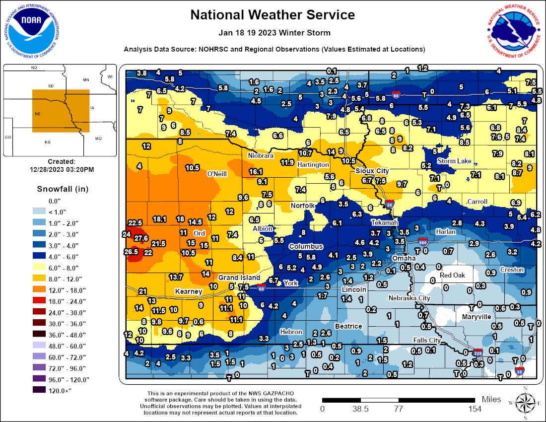
January 18-19, 2023 - Heavy Snowfall in Northeast Nebraska
A powerful winter storm impacted the region on January 18-19, 2023. This storm dropped more than a foot of snow in northeast Nebraska, and near two feet in central Nebraska. The highest amount reported in the NWS Omaha forecast area was 16.1 inches from a COOP observer near Orchard. The highest in the state was 24.0 inches from a COOP observer near Anselmo (about 60 northeast of North Platte). The storm produced a challenging forecast zone amidst a sharp cut off from heavy snow to a mix of sleet, freezing rain, and lighter snow totals. Areas south of the heaviest snow had their snowfall totals undercut by warmer temperatures that resulted in precipitation falling as freezing drizzle and ice pellets during the afternoon.
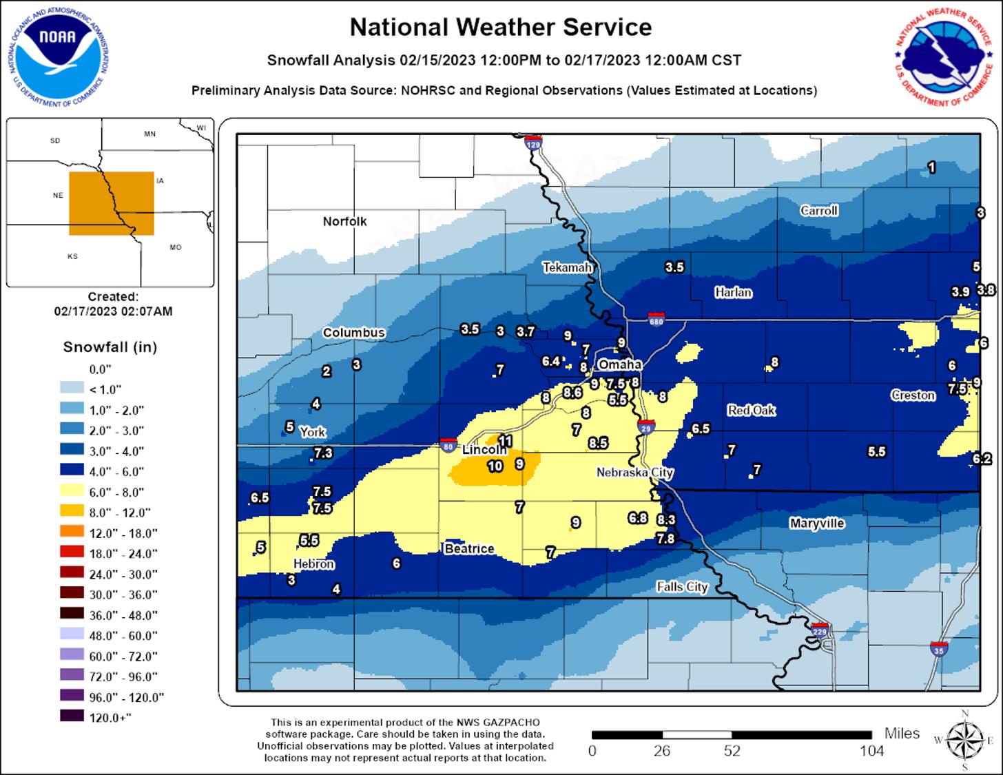
February 15-16, 2023- Heavy Snowfall Along I-80
A cold front passage on February 15 resulted in a temperature drop from the 40s and 50s down into the 10s and 20s. A low pressure system tracked across the Southern Plains which drew moisture north and wrapped around the low. The heaviest snowfall fell along I-80 with the highest amounts in the city of Lincoln. The official observation at the Lincoln Airport was 8.8 inches which was the highest amount since January 25, 2021 (14.5 inches). There were reports of 10 to 11 inches across the city. A wide swatch of 6+ inches fell across 12 counties in the forecast area.
April 11-13, 2023 - Red Flag Warnings and Wildfires
A Red Flag Warning was in effect each day from April 11-13 due to strong winds, low moisture, and ongoing impacts from the drought. There were several fires in eastern Nebraska and southwest Iowa. The largest fire in the area was in Jefferson County and started on Tuesday April 10 and led to two injuries. NWS Omaha provided approximately 20 hot spot notifications to local officials for fires detected via satellite imagery during this period.
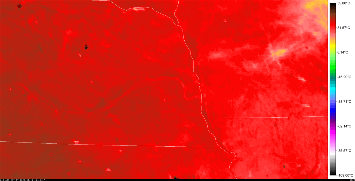
Satellite imagery from GOES ABI Band 7 from the afternoon of April 11. The dark spots indicate wildfires. In the NWS Omaha service area, there were fires in Jefferson County and Mills County.
April 19, 2023 - Large Hail in Nebraska City
On the evening of April 19, severe weather developed along a stalled boundary in southeast Nebraska. This was primarily a hail event, but 3 tornadoes rated EF-U were observed in southwest Iowa (2 near Thurman, 1 near Carson). A total of 47 hail reports ranging from 1 to 3 inches were received by NWS Omaha. The reports for 3-inch hail (teacup sized) came from Nebraska City and Thurman, IA. It was estimated that approximately 80 to 90% of Nebraska City suffered from hail damage. The city received several rounds of severe hail with the first report coming at 5:52 PM and the final reporting received at 7:10 PM.
May 12, 2023 - Tornado Outbreak and Large Hail
A strong low-pressure system which had been slowly moving east off the Rocky Mountains finally progressed into central Nebraska. This left eastern Nebraska in the warm sector as a warm front moved north into the area. The SPC issued an Enhanced Risk for severe weather with a 30% hatched for severe hail. There were 19 confirmed tornadoes (3 EF-2, 8 EF-1, 4 EF-0, 4 EF-U). The longest-lived tornado was rated an EF-2 and started approximately 4.5 miles southwest of Oakland in Burt County. The tornado was on the ground for 24 minutes and moved due north for approximately 12 miles, terminating 2.8 miles west of Lyons. Max wind speeds were estimated at approximately 120 mph and destroyed multiple outbuildings across various farmsteads. The other two EF-2 tornadoes occurred in Dodge and Burt counties.
In addition to the tornadoes, there were numerous hail reports across the area. The largest hail report was 4.5 inches in Table Rock in Pawnee County. Another 4-inch report was received near Humboldt in Richardson County. Flash flooding was also observed in a few locations. The most impactful flooding occurred in Harrison County where it was reported that up to two dozen culverts were washed out and six county roads that were partially or fully washed out. Large trees were washed into fields and there was significant damage to farm fields in several areas in the counties. There are significant areas of crop fields that likely lost in excess of 100 tons per acre. A report of 4.4 inches of rainfall was submitted in Harrison County near the flash flood.
Radar imagery from the afternoon and evening of May 12. Tornado warnings are in the red polygons and severe thunderstorm warnings are in yellow.
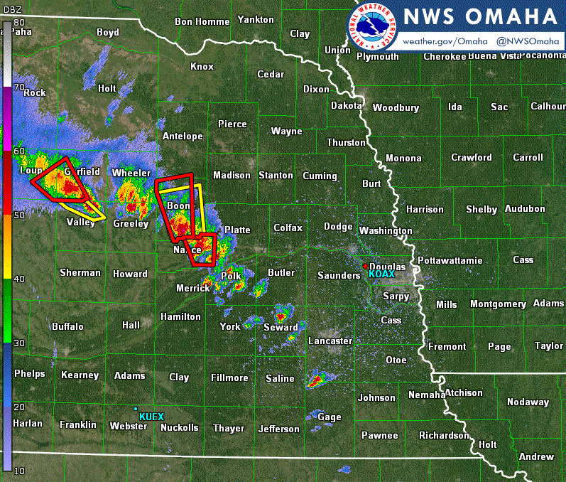
July 4, 2023 - Thunderstorms and Postponed Fireworks
On the afternoon of July 4, a few clusters of thunderstorms developed in northeast Nebraska and produced numerous hail reports. The hardest hit location was Platte County where the towns of Monroe, Humphrey, Lindsay, and Tarnov each observed 2+ inch hail. The largest report was 2.75” near Tarnov. As the afternoon turned into the evening, the storms evolved from a hail threat to a damaging wind threat. South of the Platte River, a clustered line of storms produced 60 to 80 mph. The strongest measured wind gust was 79 mph near Elmwood in Cass County. There were numerous reports for tree damage in southeast Nebraska. Due to the timing of the storms, many towns and organizations in southeast Nebraska and southwest Iowa decided to postpone their Independence Day celebrations until the following day. Though the storms interrupted evening events, it did bring widespread beneficial rainfall.
July 12, 2023 - Early Morning Strong Winds and Embedded Tornadoes
A significant damaging wind storm tracked across nearly all of eastern Nebraska and western Iowa on the morning of July 12. These storms produced widespread winds of 60 to 80 mph, with embedded stronger downbursts with wind speeds up to 100 mph. The strongest measured wind gust was 82 mph near Uehling in Dodge County, but some of the high-end straight-line wind damage supported embedded wind speeds up to 100 mph.
This system also produced a few embedded tornadoes. The strongest tornado was rated an EF-2 and occurred in Harrison County. It started south of Logan and traveled for 9.4 miles to the southeast before it terminated near Persia. The tornado damaged a home, some outbuildings, and caused substantial tree damage. The peak winds were estimated at 120 mph. In addition to the EF-2 tornado, four were rated EF-1, and 2 others were rated EF-0. Some of the tornado tracks were only identified by narrow swaths of damage through mature cornfields, with minimal damage otherwise and peak wind speeds similar to the nearby downburst winds. All but one of the tornadoes was preceded by a Wireless Emergency Alert. There were 0 reported injuries or fatalities. Additionally, approximately 33,000 customers lost power as the strong winds downed power poles and lines across the Omaha metro area.
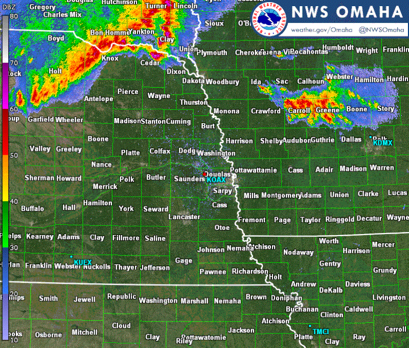
Radar imagery from the morning of July 12.
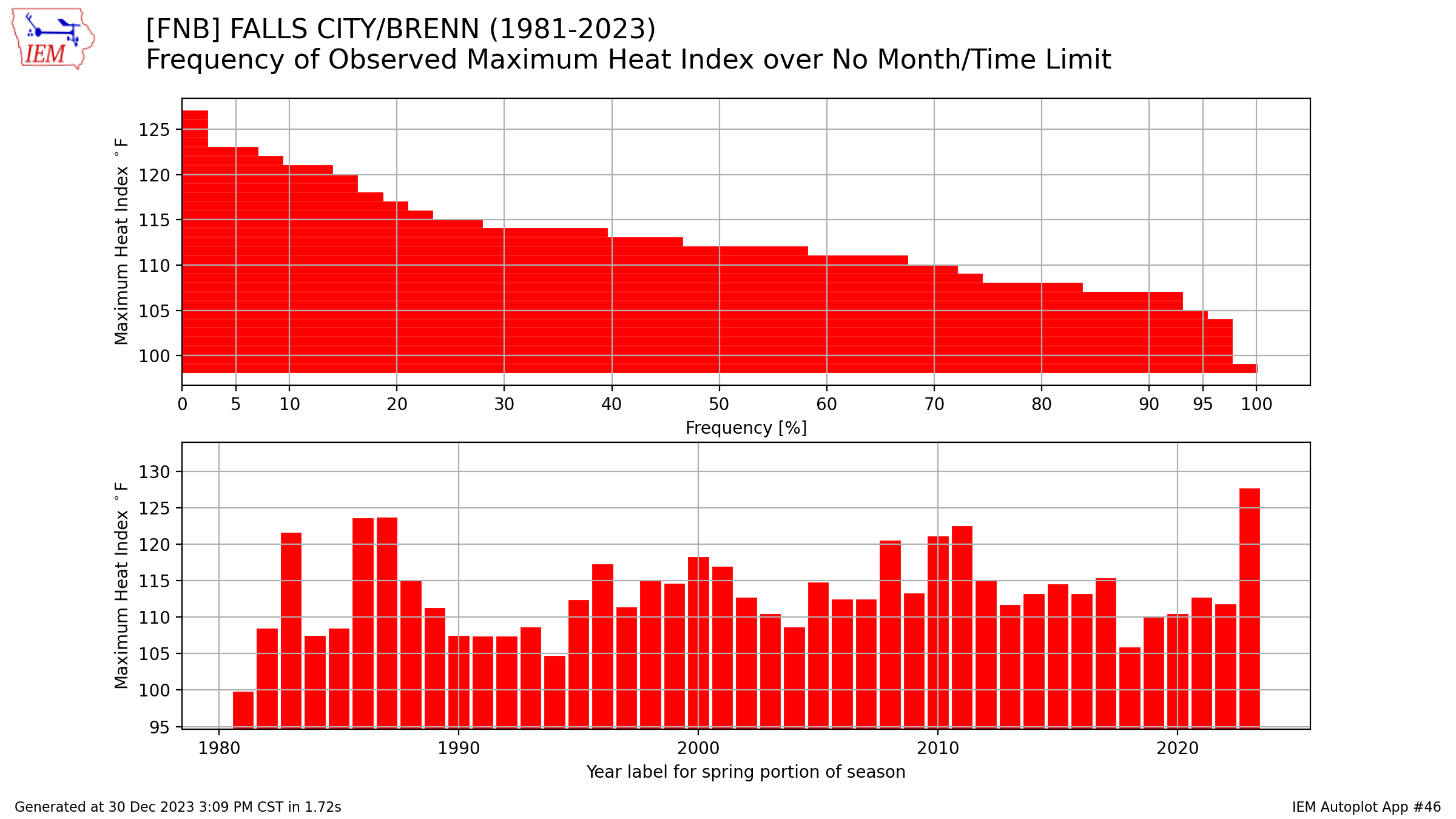
August 19-23, 2023 - Heat Wave
An Excessive Heat Warning was in effect for portions of the forecast area for 7 days as a heat wave dominated the area. This was the longest duration Excessive Heat Warning that the Omaha office has issued. A total of 10 temperature records at Omaha, Lincoln, and Norfolk were tied or broken as the air temperature routinely topped 100° and overnight low temperatures largely remained above 75°. High dew points led to heat indices that routinely topped 110°.
The heat wave began on August 19 as a mid-level ridge moved over the central US. A temperature of 107° was observed at Beatrice as strong afternoon mixing led to a rapid drop in the dewpoint and a spike in temperature. This was the highest observed temperature by an automated station during the heatwave. Roughly 70 miles to the east, Falls City reached a temperature of 99° with a dew point of 84° which resulted in a heat index of 128°. That 128° heat index was the highest of the entire country during the heatwave. It may be the highest observed heat index ever for Nebraska.
A cold front moved into the area on August 20, but only brought relief to northeast Nebraska where temperatures were mostly at or below 90° The heat continued in southeast Nebraska and southwest Iowa where heat indices ranged between 105° and 110° as temperatures were in the mid-90s and dew points in the upper 70s.
The Excessive Heat Warning was expanded to include the entire forecast area on Monday August 21 and was in effect for the entire area through Thursday August 24. The warning was in effect on August 25 for southeast Nebraska (including the cities of Omaha and Lincoln) and southwest Iowa. Temperatures during this period routinely reached 100° and heat indices topped 110°. Little relief was had at night as overnight temperatures remained above 75°. Lincoln observed 5 straight days of 100° temperatures from Aug 21-25 (and 6 of 7 days including Aug 19). That was the longest such streak for Lincoln since July 21-25, 2012.
In addition to broken temperature records, new records were set at the office for the highest 500 hPa height as determined by the balloon launches. The August 21 00Z sounding had a 6010 m 500 hPa height which broke the previous record of 6000 m (July 18, 2011). The next 3 balloon launches would all break or match the previous record.
2023 Climate Extremes
(Data from NWS Cooperative & CocCoRaHs/NeRAIN observers)
Hottest Temperatures
Coldest Temperatures
Highest Yearly Precipitation
Lowest Yearly Precipitation
Highest 24-Hour Rain Totals (From 7 am to 7 am ending on the specified date)
Highest 24-Snowfall Totals (From 7 am to 7 am ending on the specified date) (Only used highest total of closely located stations)
Highest Storm-Total Snowfall Totals (highest 1-2 day totals) (Only used highest total of closely located stations)
New (or Tied) Daily Climate Records
|
Maximum Temperature |
||||
| Location | Date | New Record | Old Record | Year |
| Norfolk | April 12 | 91 | 90 | 2022 |
| Lincoln | April 13 | 89 | 89 | 1936 |
| Norfolk | April 13 | 90 | 90 | 1908 |
| Lincoln | August 19 | 104 | 100 | 1921 |
| Norfolk | August 21 | 100 | 100 | 1914 |
| Lincoln | August 22 | 105 | 103 | 1948 |
| Lincoln | August 23 | 103 | 103 | 1943 |
| Norfolk | September 2 | 101 | 101 | 1956 |
| Norfolk | September 3 | 99 | 98 | 1913, 1925 |
| Omaha | September 29 | 95 | 92 | 1971 |
| Lincoln | September 29 | 96 | 94 | 2002 |
| Norfolk | September 29 | 95 | 92 | 1991 |
| Omaha | September 30 | 94 | 93 | 1952, 1994 |
| Lincoln | September 30 | 96 | 94 | 1952 |
| Lincoln | October 1 | 94 | 94 | 2006 |
| Omaha | December 7 | 61 | 61 | 1918 |
|
Minimum Temperature |
||||
| Location | Date | New Record | Old Record | Year |
| Omaha | April 23 | 26 | 28 | 2013 |
| Lincoln | April 23 | 21 | 26 | 1996 |
| Norfolk | April 23 | 22 | 23 | 1910 |
| Norfolk | July 6 | 50 | 51 | 2006 |
|
Low Maximum Temperature (Cold high temperatures) |
||||
| Location | Date | New Record | Old Record | Year |
| NO NEW RECORDS SET OR TIED | ||||
|
High Minimum Temperature (Warm low temperatures) |
||||
| Location | Date | New Record | Old Record | Year |
| Norfolk | April 12 | 59 | 58 | 1916 |
| Omaha | August 22 | 80 | 76 | 1878, 1975 |
| Lincoln | August 22 | 78 | 77 | 1968 |
| Norfolk | August 22 | 78 | 76 | 1968 |
| Omaha | August 24 | 76 | 76 | 2021 |
| Omaha | September 29 | 68 | 67 | 1995 |
| Norfolk | September 29 | 64 | 64 | 1995 |
| Omaha | September 30 | 74 | 72 | 2019 |
| Lincoln | December 15 | 39 | 39 | 1894 |
| Norfolk | December 15 | 35 | 34 | 2001 |
|
Maximum Precipitation |
||||
| Location | Date | New Record | Old Record | Year |
| Omaha | January 18 | 0.52" | 0.40" | 1979 |
| Lincoln | January 18 | 0.82" | 0.45" | 1975 |
| Norfolk | January 18 | 0.51" | 0.39" | 1975 |
| Omaha | February 28 | 0.98" | 0.62" | 1969 |
| Omaha | July 1 | 1.60" | 1.50" | 1931 |
| Lincoln | August 26 | 2.24" | 1.72" | 1996 |
| Norfolk | September 23 | 1.03" | 0.82" | 2014 |
| Norfolk | October 26 | 3.19" | 0.55" | 1998 |
| Omaha | December 24 | 0.84" | 0.79" | 1875 |
|
Maximum Snowfall |
||||
| Location | Date | New Record | Old Record |
Year |
| Norfolk | January 18 | 6.3" | 4.2" | 1975 |
| Lincoln | February 16 | 8.8" | 4.0" | 1939 |
| Norfolk | October 28 | 0.7" | 0.1" | 1991 |

