Top Weather Events of 2022
Here is a look back at some of the notable weather events that occurred in eastern Nebraska and southwest Iowa in 2022. Below the events are climate records and other facts from the year.
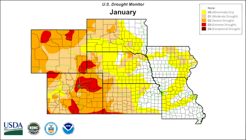
The Drought
The area started the year with drought concerns as portions of eastern Nebraska were classified as Abnormally Dry (D0) or in a Moderate Drought (D1) according to the Drought Monitor. The drought worsened as the year progressed. The 2021-22 winter was one of the driest on record with only Omaha reaching double digits snowfall for the season (10.8”). It was the least snowy winter in Lincoln (5.1”) and the 3rd least in Norfolk (4.1”). By April, most of the region was classified as in a Severe Drought (D2). The dryness was apparent during the month of April as a total of 11 Red Flag Warnings (RFWs) were in effect on the month and for 4 straight days from April 11-14. A total of 27 RFWs were issued on the year which is the most ever for the Omaha/Valley office. Late spring and early summer rains provided some improvement of drought criteria, most notably in southeast Nebraska where the year’s highest rainfall totals were observed. However, a dry late summer and fall led to an expansion and degradation of drought conditions. Northeast Nebraska was classified as in Exceptional Drought (D4) in September, which is the worst drought classification. By November, most of the region was classified as Severe Drought (D3). The last year to end with this level of drought classification was 2012 when 33% of the area was classified as in Exceptional Drought (D4). Exceptional Drought is the worst category of drought classification.
April 12-13, 2022 - Storms, Record High Temperatures, Record Temperature Drop
A strong low pressure system brought a surge of warm, moist air to the north. South winds in the morning and afternoon gusted between 40 to 55 mph across southeast Nebraska and southwest Iowa. The high temperature record was broken at all 3 climate sites by 5°. A cold front moved into the area from the northwest which initiated a line of storms which produced 4 confirmed tornadoes and 38 storm reports for hail and damaging wind gusts. Two of the 4 tornadoes were located in Harrison County, 1 in Otoe County, and 1 in Seward County.
Northwest winds on the backside of the front were strong with 60 mph wind gusts observed at Norfolk and Wayne. Cold air advection behind the front resulted in one of the largest observed 24-hour temperature drops on record at Norfolk and Lincoln. Omaha observed its 2nd largest drop. Afternoon high temperatures were in the 90s on the 12th before dropping into the 20s and 30s the next morning. The previous records occurred on April 2-3,1982 (table below). Of note, April 2, 1982 was a large tornado outbreak, though no tornadoes occurred in Nebraska. Iowa recorded 1. It was the first day the Severe Local Storms Unit (now called the Storm Prediction Center) issued its first officially documented high risk as well as the first tornado watch to contain the wording Particularly Dangerous Situation.
| Location | April 12 Max | April 13 Min | Difference | Previous Record |
|---|---|---|---|---|
| Norfolk | 90 | 25 | 65 | 57 |
| Lincoln | 91 | 31 | 60 | 57 |
| Omaha | 91 | 32 | 59 | 63* |
| Oakdale, NE | 86 | 21 | 65 | 56 |
| Albion | 88 | 23 | 65 | 55 |
| Columbus | 90 | 26 | 64 | N/A |
| Wayne | 88 | 26 | 62 | N/A |
| David City 4E | 88 | 27 | 61 | 56 |
| Friend 3E | 90 | 29 | 61 | N/A |
| Seward | 90 | 29 | 61 | 55 |
| Springfield 7E | 92 | 31 | 61 | N/A |
| West Point | 87 | 26 | 61 | 55 |
| Blair | 90 | 29 | 61 | 63* |
| Tekamah | 92 | 31 | 61 | 58 |
| Wahoo | 90 | 29 | 61 | 60 |
| Little Sioux 2NW | 90 | 30 | 60 | N/A |
| Council Bluffs | 90 | 30 | 60 | N/A |
| Fremont | 89 | 30 | 59 | 62* |
| Gretna | 89 | 30 | 59 | N/A |
| Offutt AFB | 91 | 32 | 59 | N/A |
| Plattsmouth | 91 | 32 | 59 | N/A |
| Valley NWS | 89 | 30 | 59 | N/A |
| Beatrice | 89 | 31 | 58 | 56 |
| Nebraska City | 90 | 32 | 58 | N/A |
| Mead 6S | 89 | 32 | 57 | 53 |
| Verdel 6SSE | 78 | 22 | 56 | N/A |
| Harlan | 86 | 30 | 56 | 64* |
| Red Oak | 88 | 32 | 56 | 71* |
| Auburn 5ESE | 93 | 38 | 55 | 60* |
| Fort Calhoun 4W | 80 | 25 | 55 | N/A |
| Oakland, IA | 87 | 32 | 55 | 66* |
April 28, 2022 - An Hour of Hail
A meandering and sometimes stationary series of thunderstorms led to hail falling for nearly an hour in parts of Madison and Platte counties. Hail covered the ground as if it was snowfall. Highways in the area had visible paths through the hail. The largest hailstones were about 2 inches in diameter. In addition to the hail, a wide swatch of 5 to 7 inches of rain were observed across the county with Platte Center reporting 7.5 inches of rain (there was an unofficial report of 10 inches north of town). Several flash flood and flood warnings were issued for the area. There were several reports of water across roads with US81 being closed temporarily between Norfolk and Columbus. Additionally, Elm Creek experienced a flash flood that led to water entering several homes and businesses in Platte Center.
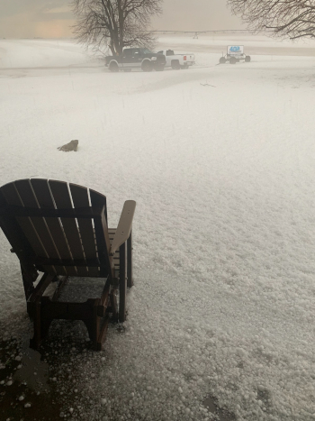
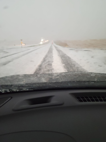
Credit: Janel Sueper Credit: Renee Engel Stallbaumer
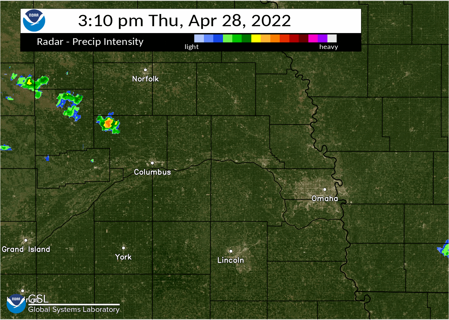
April 2022 - A Windy, Dry Month
The wind already seemed like it was constantly blowing over the winter and it did not change in April. Omaha, Norfolk, and Lincoln all observed one of their windiest months on record observing monthly average wind speeds not seen since the 70s and 80s. Of particular note was April 23 when a High Wind Warning was in effect for most of northeast Nebraska and western Iowa. Several locations recorded peak wind gusts of at least 60 mph. At Omaha, Lincoln, and Norfolk it was the 4th, 7th, and 9th fastest average daily wind speed on record. The fastest daily average wind speed was at Tekamah which observed an average of 30.6 mph where the wind gusted above 40 mph for much of the day.
In addition to the wind speed, the lack of moisture was also noted with issuance of 11 Red Flag Warnings (Red Flag Warnings are issued based on a combination of strong winds and low relative humidity) on the month. No more than 5 days passed without an RFW being in effect for a portion of the area. The 11 RFWs issued was more than the 10 issued for all of 2021.
Top 10 Monthly Average Wind Speeds (mph)
| Norfolk | Omaha | Lincoln |
| 20.2 - Jan 1949 | 16.5 - Apr 1960 | 14.8 - Apr 1984 |
| 18.8 - Apr 1951 | 15.6 - Mar 1950 | 14.5 - Mar 1950 |
| 18.6 - Mar 1951 | 15.6 - Mar 1951 | 14.5 - Apr 2022 |
| 18.2 - Mar 1950 | 15.3 - Apr 1950 | 14.2 - Apr 1978 |
| 17.6 - Mar 1949 | 15.2 - Apr 1951 | 13.9 - Apr 1948 |
| 17.6 - Apr 1950 | 15.1 - Apr 1956 | 13.8 - Apr 1951 |
| 17.0 - Apr 1948 | 14.9 - Mar 1954 | 13.7 - Jan 1949 |
| 17.0 - Feb 1949 | 14.9 - Apr 2022 | 13.7 - Apr 1974 |
| 16.5 - Apr 2022 | 14.8 - Mar 1956 | 13.7 - Mar 1979 |
| 16.3 - Mar 1966 | 14.8 - Apr 1973 | 13.6 - Apr 1954 |
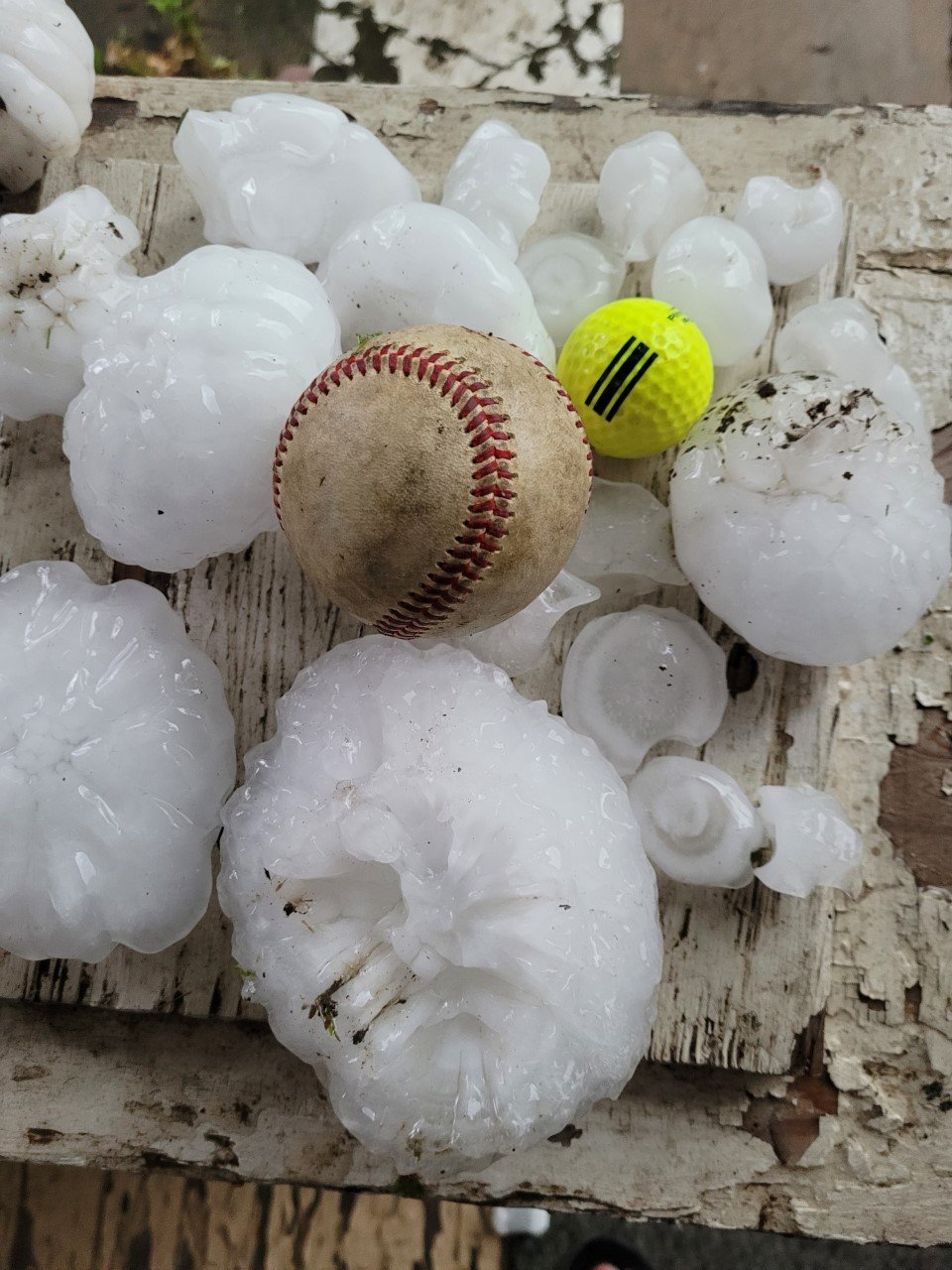
June 11, 2022 - Very Large Hail and Tornadoes
A couple of strong supercells developed in Saline and Gage counties producing very large hail in Beatrice. Numerous large hail reports were received with the largest being 5 inches. That 5-inch report was the largest ever transmitted by the Omaha/Valley office via a Local Storm Report (LSR). In addition to the hail, two tornadoes were confirmed. One near Blue Springs and another that developed near Wymore. The tornado that developed near Wymore was rated an EF1 that had a path length of approximately 4 miles. It tracked south across the Kansas border before dissipating in the Topeka service area.
Credit: Jason Thavenet
June 14, 2022 - Wind Driven Hail
A cluster of supercell thunderstorms moved through the region during the evening of Tuesday June 14 into the early morning hours of June 15. The storms produced widespread wind gusts of 75 to 115 mph, hail up 1 to 3 inches in diameter, and two EF-1 rated tornadoes. The wind and hail combined to cause terrible damage in Seward County. Crops were destroyed to the extent that some fields appeared as if nothing had been planted in them despite being full and green prior to the storm. Numerous homes had their siding and windows completely destroyed and trees were debarked due to the wind driven hail. The hardest hit area was in a 2-to-7-mile wide (north to south) area extending from the York County line through 5 miles east of Seward and running along and south of Highway 34. The storms continued east across south central Nebraska and produced an EF-1 tornado in Cass County and another in Pottawattamie County. You can read more about the tornadoes and the event from the link above.

October 23, 2022 - Strong Winds and Grass Fires
A common theme on the year, this day featured strong southerly winds resulted in record warm temperatures and wind gusts above 30 mph for most of the day. Omaha, Lincoln, Norfolk all broke their max temperature record. Winds gusted above 30 mph for most of the day with peak wind gusts reported between 40-60 mph. Several grass fires developed across the region, which became difficult to control due to the strong, gusty winds. A mandatory evacuation was ordered for the town of Wisner. Volunteer evacuations were in effect in Lancaster, Gage, and Harrison counties where large grass fires developed and required multiple rural fire departments to get under control.
In addition to grass fires, a single severe storm developed in Boone County, eventually split into 2, and continued into a few counties. The storm produced several gusts above 60 mph with an observed peak gust of 72 mph in Pierce County.
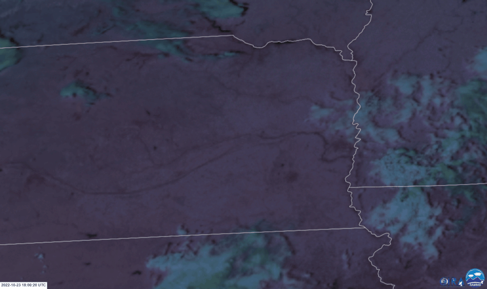
Satellite imagery from 11 am until 6 pm. Grass fires indicated by areas in red.
December 21-24 - Dangerously Cold Wind Chills
A southerly descent of the polar jet stream allowed for the polar vortex to plunge south into the continental US bringing blizzard and dangerously cold conditions for millions of people. Wind Chill Warnings were in effect from the Canadian border down to the Gulf of America. Closer to home, a Wind Chill Warning was in effect for the entire forecast area for over 48+ hours. Several locations observed wind chill temperatures of at least -50° (Albion -50°, Fordyce -51°, Hedriw -51°). Almost impossible to confirm, but those wind chills are likely some of the coldest observed ever in the region. Omaha observed its 7th coldest wind chill (-42°) since 1948. The most recent comparable event was February 2021 when air temperatures dropped below -30° at several locations. The coldest air temperature observation for this event was -22° in Fairbury. The combination of the wind and cold temperatures led to conditions that felt colder than even the February 2021 event. The extended period of cold combined with the effects of the drought resulted in an ice jam forming on the Missouri River near Omaha for the first time since 1989. Ice can form more easily on the river when the stage is low, and the flow is slower.
Snowfall amounts mostly underwhelmed with a peak of 3.0” observed near Auburn. Blizzard like conditions were observed in several locations as the wind and snowfall reduced visibility down to a quarter of a mile for an hour or two.
2022 Climate Extremes
(Data from NWS Cooperative & CocCoRaHs/NeRAIN observers)
Hottest Temperatures
Coldest Temperatures
Highest Yearly Precipitation
Lowest Yearly Precipitation
Highest 24-Hour Rain Totals (From 7 am to 7 am ending on the specified date)
Highest 24-Snowfall Totals (From 7 am to 7 am ending on the specified date) (Only used highest total of closely located stations)
Highest Storm-Total Snowfall Totals (highest 1-2 day totals) (Only used highest total of closely located stations)
New (or Tied) Daily Climate Records
|
Maximum Temperature |
||||
| Location | Date | New Record | Old Record | Year |
| Norfolk | January 18 | 62 | 61 | 1951 |
| Norfolk | February 20 | 66 | 66 | 1930 |
| Omaha | March 2 | 79 | 76 | 1992 |
| Lincoln | March 2 | 81 | 79 | 1904 |
| Lincoln | March 20 | 80 | 79 | 1934 |
| Omaha | April 12 | 91 | 86 | 1916 |
| Lincoln | April 12 | 91 | 86 | 2006 |
| Norfolk | April 12 | 90 | 85 | 1908 |
| Omaha | May 11 | 96 | 93 | 2000 |
| Omaha | May 12 | 97 | 93 | 1956 |
| Omaha | June 13 | 101 | 101 | 1952 |
| Lincoln | June 13 | 103 | 102 | 1952 |
| Norfolk | June 13 | 102 | 102 | 1952 |
| Omaha | September 20 | 99 | 95 | 2018 |
| Lincoln | September 20 | 103 | 96 | 2016 |
| Norfolk | September 20 | 100 | 100 | 1895 |
| Omaha | October 23 | 87 | 84 | 1899 |
| Lincoln | October 23 | 89 | 84 | 1899 |
| Norfolk | October 23 | 89 | 87 | 1927 |
| Omaha | November 9 | 75 | 73 | 1999 |
| Lincoln | November 9 | 78 | 74 | 1999 |
|
Minimum Temperature |
||||
| Location | Date | New Record | Old Record | Year |
| Omaha | April 26 | 28 | 29 | 1931 |
| Lincoln | April 26 | 25 | 27 | 1907 |
| Norfolk | April 26 | 21 | 25 | 1907 |
| Lincoln | May 22 | 34 | 36 | 1963 |
| Lincoln | June 2 | 42 | 43 | 1978 |
| Norfolk | June 2 | 37 | 38 | 1910 |
| Norfolk | June 28 | 46 | 46 | 1968 |
| Omaha | October 18 | 16 | 20 | 1871 |
| Lincoln | October 18 | 18 | 21 | 1972 |
| Norfolk | October 18 | 15 | 18 | 1972 |
|
Low Maximum Temperature (Cold high temperatures) |
||||
| Location | Date | New Record | Old Record | Year |
| Omaha | May 2 | 45 | 45 | 1953, 1954 |
| Lincoln | May 26 | 53 | 56 | 1992 |
| Norfolk | June 20 | 76 | 76 | 1936 |
|
High Minimum Temperature (Warm low temperatures) |
||||
| Location | Date | New Record | Old Record | Year |
| Omaha | May 11 | 70 | 67 | 1879 |
| Omaha | June 13 | 79 | 78 | 1952 |
| Lincoln | June 13 | 78 | 77 | 1952 |
| Lincoln | June 19 | 77 | 77 | 1936 |
| Norfolk | June 19 | 76 | 76 | 2012 |
| Omaha | June 20 | 76 | 76 | 1937 |
| Lincoln | June 20 | 78 | 76 | 1937 |
| Norfolk | June 20 | 79 | 74 | 1989 |
| Lincoln | November 9 | 64 | 52 | 1999 |
|
Maximum Precipitation |
||||
| Location | Date | New Record | Old Record | Year |
| Norfolk | September 18 | 0.79 | 0.6 | 1960 |
|
Maximum Snowfall |
||||
| Location | Date | New Record | Old Record | Year |
| NO NEW RECORDS SET OR TIED | ||||

