
Wildfire smoke continues to impact air quality from the Great Lakes region into New England and the Mid-Atlantic today with widespread Air Quality Alerts in effect. Severe thunderstorms are expected across portions of the Ohio Valley and Lower Great Lakes into the Mid-Atlantic and Northeast, this afternoon into the evening. Monsoonal thunderstorms may bring areas of flooding to the Southwest. Read More >
Omaha/Valley, NE
Weather Forecast Office
48 Hour Snow Totals Ending 7 am 4/15/18
An early spring storm moved through the region April 13-14th and brought heavy snow to the area. 5 to 19 inches of snow fell in a wide swath from central Nebraska through South Dakota, northern Iowa, and Minnesota. Blizzard conditions were observed in many locations with winds gusting in excess of 50 mph. Numerous roads were closed for a time, and Interstate 80 was closed in portions of central and western Nebraska.
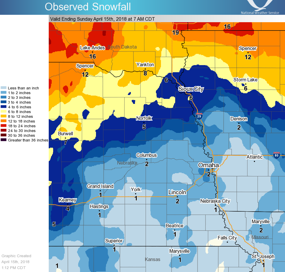
Here are some notable 2-day totals through 7 am 4/15/18
Neligh, NE 10"
Oakdale, NE 6.9"
Royal, NE 6"
Wayne, NE 6"
Bloomfield, NE 5.8"
Norfolk, NE 4-5"
Mondamin, IA 4"
Little Sioux IA, 3.4"
Omaha, NE Metro 2.5 - 3"
Lincoln, NE Metro 1.5 - 2"
NWS Valley 0.9"
Omaha Eppley, 0.6"
Warnings/Hazards
Forecast Discussion
Winter Weather
Severe Weather
Fire Weather
Drought
Storm Prediction Center
SubmitReport
Rivers And Lakes
River Forecasts
Missouri River Overview
Platte River Overview
Elkhorn River Overview
Ice Jam Risk
Local Information
Latest Briefing Packet
Weather Monitor
Winter Monitor
Preparedness
Storm Spotters
About Us
Other Useful Links
US Dept of Commerce
National Oceanic and Atmospheric Administration
National Weather Service
Omaha/Valley, NE
6707 North 288th Street
Valley, NE 68064-9443
402-359-5166
Comments? Questions? Please Contact Us.

