1. INTRODUCTION
One of the most basic tools available to the forecaster is a severe weather climatology showing trends in the annual, monthly and hourly distribution of severe weather in a given area. Forecasters need to have an understanding of the severe weather climatology in their area of responsibility in order to effectively provide forecasts and warnings of tornadoes and severe thunderstorms.
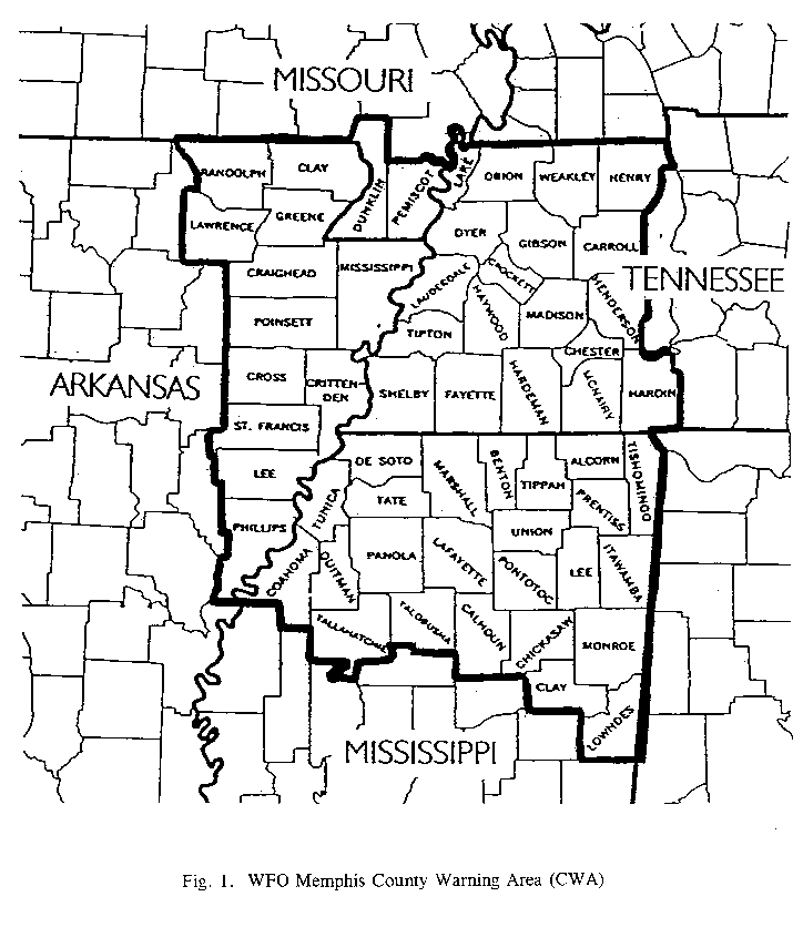
The Memphis NEXRAD Weather Service Forecast Office (NWSFO) has warning responsibility for 59 counties in the Mid-South area which includes parts of Arkansas, Mississippi, Missouri and Tennessee (Fig. 1). With the recent expansion of the county warning area (CWA), forecasters are now faced with new challenges associated with the greater diversity and higher frequency of severe weather events within this larger area.
The objectives of this study are to examine the temporal trends of severe weather events, which include damaging winds, large hail and tornadoes, for the past 40 to 45 years in the expanded Memphis CWA and to relate these findings to previous climatological research. It is hoped that this study will aid local forecasters in understanding the characteristics of severe weather in the new CWA in order to be better prepared for these events.
2. DATA
Data used in this study were obtained from the National Severe Storms Forecast Center (NSSFC) which maintains a damaging wind and hail database dating back to 1955 and a tornado database dating back to 1950. This database was modified by the CLIMO program (Vescio, 1995) which generates useful severe weather statistics for individual CWAs. Damaging wind and hail data from 1972 were not included in this database but were supplemented for this study with data obtained from the Storm Data publication.
Limitations of the data include many non-meteorological factors which have been documented in previous climatological studies (Kelly, et al., 1985). These limitations include population density, time of day, presence or absence of spotter networks, proper perception of the event by the public, apathy of the public to report events and the lack of appropriate measuring devices. Also, Kelly et al., (1985) pointed out that while one might try to weight the climatological data in terms of using population data, other demographic factors such as degree of urbanization, highway distribution, education level of the populace, etc., must be considered. However, the fact that no spatial trends are evaluated in this study should minimize any adverse effects of population density limitations.
Another important limitation regarding the tornado database is the fact that the number of tornadoes reported corresponds to how many counties were affected. For example, if a single tornado tracked across two counties, it would be appear in the data set as two tornadoes. While this obviously flaws the data, one can still use this database to assess the temporal trends of tornadoes since the majority of multiple county tornadoes are strong, long-lived tornadoes (>F2) which are not as common as their weaker, shorter-lived counterparts. Thus, it is assumed that there are not enough multiple county tornadoes to sufficiently contaminate the database.
3. DAMAGING WIND CLIMATOLOGY
a) Yearly Distribution
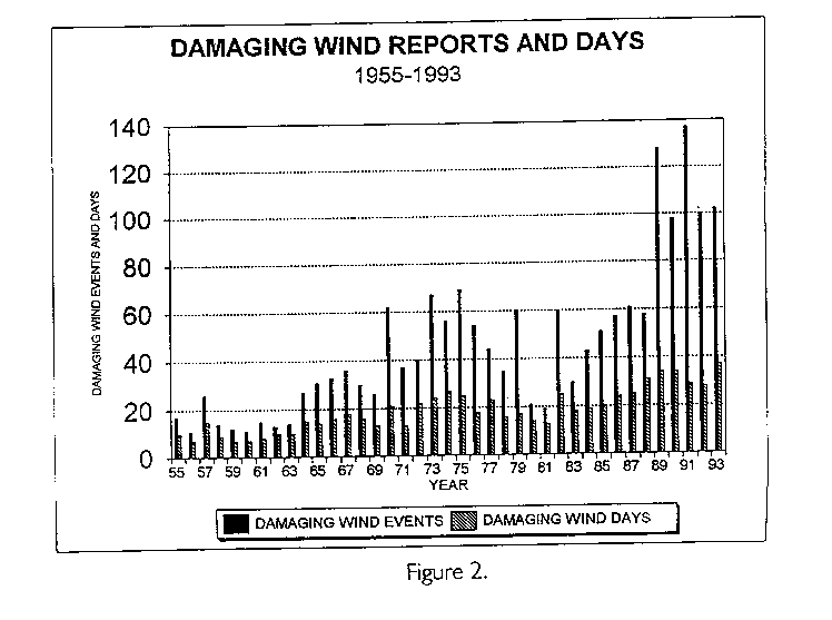
In this study, 'damaging wind' is defined as a convective wind gust that (1) reaches or exceeds 50 knots (58 mph), and/or (2) results in damage to trees, power lines or other structures. Since the mid 1950s, the number of damaging wind days has steadily risen with damaging wind reports rising dramatically. Figure 2 illustrates these trends and reveals that damaging wind reports increased markedly in the 1970s and again in the 1990s.
Although the rise in damaging wind days during these periods might have a meteorological explanation, the dramatic increase in damaging wind reports can most likely be attributed to improvements in the National Weather Service's (NWS) spotter network and an increase in the Mid-South population. An organized amateur radio spotter network was implemented in the mid 1970s for the Memphis CWA while the NWS's warning verification program was begun in 1980 (Hales, 1993).
b) Monthly distribution
The monthly distribution of damaging wind events (Fig. 3) reveals that June is the most active month for damaging wind events in the Memphis CWA. Also, the majority of damaging wind events occur between March and July, with the three month period of April through June accounting for nearly 50% of all the reported damaging wind events during the year.
Previous studies of damaging wind climatologies (Kelly, et al., 1985) indicate that for the entire United States, the summer months of June through August account for nearly 55% of all yearly reports. The fact that the highest frequency of damaging wind events in the Memphis CWA occurs earlier in the year is not surprising, since severe thunderstorms occur earlier in the year for the southern U.S. as compared with the rest of the country. A small secondary maximum is also evident in November for the Memphis CWA, which coincides with the previously documented November peak in severe weather throughout the southeastern U.S. (Kelly, et al., 1985).
c) Hourly distribution
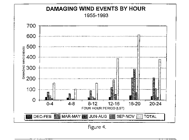
From Figure 4, it is seen that in every season of the year, damaging wind reports reach a maximum during the late afternoon and early evening hours, specifically between 4 PM and 8 PM Local Standard Time (LST). In fact, the hours between noon and midnight account for nearly 75% of all damaging wind reports. This isn't surprising since most damaging wind reports are the result of convective activity which follows a diurnal peak during the late afternoon and early evening hours.
There is also an interesting trend seen in Figure 4 with respect to the diurnal and seasonal distribution of damaging wind events. During the summer months, damaging wind reports are strongly skewed toward the hours between noon and 8 PM. In fact, the number of summertime reports during this time period exceeds the number of springtime reports, which are consistently the most numerous at all other times of the day. This trend emphasizes the fact that summertime damaging wind events occur almost exclusively in association with convectively driven storms with little or no dynamical forcing. All seasons of the year show a maximum during this same time period, but none are as skewed to the same degree as the summer season.
4. HAIL CLIMATOLOGY
a) Yearly Distribution
The NWS classifies a thunderstorm as being severe if it produces hail equal to or greater than 3/4 of an inch in diameter. Therefore, this study only examines reports of hail that meet or exceed this NWS criteria for severe thunderstorms. The annual distribution of hail reports and hail days (Fig. 5), like the damaging wind annual distribution, reveals an upward trend in the number of reported hail events in the Memphis CWA. The first substantial increase in hail reports is seen during the 1970s, with a decrease around the early 1980s and then another substantial increase in reports since the mid 1980s (which is the same trend seen in Fig. 2). Although the number of reports has risen markedly since the mid 1980s, the number of hail days have increased only slowly with not much difference seen since the 1970s. This once again emphasizes the fact that improved communications, increased verification efforts and a larger regional population have helped to increase the number of reports gathered per severe weather event.
b) Monthly Distribution
From Figure 6, it is seen that hail occurs most frequently in the Memphis CWA during the months of March through June (74% of all reports) with May being the most active month. Also, a secondary maximum of reports is observed for November. These findings are consistent with other documented hail climatologies for the contiguous U.S. (Kelly, et al., 1985 and Sammler, 1993).
Monthly hail reports in this study are divided into three groups based on the size of the hail reported:
Giant size hail: 1.75-2.74 inches in diameter
Enormous size hail: 2.75 inches or greater in diameter
After dividing the hail reports into these three categories, it is noted that the number of giant hail reports reach a maximum in May and nearly equal the number of large hail reports. This monthly distribution of hail sizes also reveals a greater percentage of large hail compared with giant hail during the cool season (January-March) than in the warmer months which coincides with earlier findings by Sammler (1993). Enormous hail reports are almost exclusively a March through June phenomena, with November being the only other month in which enormous hail is reported.
c) Hourly Distribution
Figure 7 shows the hourly distribution of hail occurrences, and demonstrates that the hourly hail distribution is strongly skewed toward the late afternoon and early evening hours for all seasons of the year. In fact, the hours between 4 PM and 8 PM account for 45% of all hail reports with the afternoon and evening hours between noon and midnight accounting for 86% of all hail reports. This temporal trend of hail reports is the same for all seasons with the spring months receiving the greatest amount of reports at all hours of the day.
However, the autumn months reach a maxima of hail reports during the hours of noon and 4 PM which is different from all other seasons. The fact that sunset, and consequently the time of maximum solar heating, is earlier in the day during the autumn months doesn't fully explain this unusual finding since the winter months have basically the same or slightly earlier time of solar maxima but exhibited a later maxima of hail reports. A possible explanation of the earlier maxima of severe weather during the autumn months is that most severe weather events during the autumn months are primarily the result of strong, dynamically forced storms resulting from synoptic scale systems while severe weather events during other seasons of the year have more convectively driven storms resulting from mesoscale forcing mechanisms.
5. TORNADO CLIMATOLOGY
a) Yearly Distribution
From 1950 to 1993, 613 tornadoes were reported in the Memphis CWA with an average of 14 occurring each year(Fig. 8). These tornadoes killed 227 people, or about five each year. Tornadoes occurred during each of the 44 years, during every month of the year, and at all hours of the day.
A county-by-county analysis of reported tornadoes in the Memphis CWA indicates that population plays a large role in the number of reported tornadoes in the area. Over 80% of the CWA's tornadoes reported from 1950 to 1993 occurred in Shelby County, Tennessee (the area's most populous county with the Memphis metropolitan area) with lesser numbers of tornadoes reported farther away from Memphis. As previous studies (McNulty, et al., 1979) have noted, the more densely populated an area, the higher the number of reported tornadoes. But at the same time, it is interesting to note that no one was killed by tornadoes in Shelby county between 1950 and 1993. The lack of deaths in Shelby county might be attributed to the fact that most of the major television and radio stations in the area, as well as the NWS radar site, are located in Memphis/Shelby County where residents are more likely to receive timely warnings of approaching tornadoes. However, with the recent implementation of Doppler radar, as well as improved communication technologies, it is expected that warnings will not be as population biased or location biased as before.
b) Monthly Distribution
Most Mid-South tornadoes occur during the spring months, with 52% of the annual total reported during March, April and May. Of these months, April is the most active, with 22.5% of the yearly total. The least active tornado months are August and October, with 1.6% of the annual total in each month. Figure 9 illustrates the monthly distribution of tornadoes.
Previous tornado climatologies (McNulty, et al., 1979), have noted the presence of a secondary "tornado season" during November and December over the southeastern United States. Analysis of the Memphis CWA tornado statistics clearly points out the presence of such a secondary maximum. In fact, 21% of the annual tornado reports occur during the late autumn and early winter months, with 16.9% occurring in November and December. Some of the area's most damaging and deadly tornadoes have occurred during the late autumn and early winter months.
c) Hourly Distribution
Mid-South tornadoes have occurred at all times of the day and night (Fig. 10), but strike most often between 3 PM and 7 PM Local Standard Time (LST) which coincides with the time of maximum diurnal heating. Closer inspection of the hourly distribution graph indicates that strong tornadoes outnumber weak tornadoes during the morning hours between 6 AM and 9 AM which is opposite from the other hours of the day. A possible explanation of this observation is that early morning tornadoes are created primarily from synoptic scale systems which are more likely to produce strong, dynamically forced tornadic storms than their counterparts, convectively driven tornadic storms resulting from mesoscale forcing mechanisms. Convectively driven storms are unlikely during the morning hours since this is usually the time of day when temperatures are at a minimum.
d) Intensity
Tornado researchers use the Fujita scale of tornado intensity to classify tornadoes according to the amount of damage they produce (Schaefer, et al.,1979). This study classifies tornadoes according to this scale and uses the terms weak (F0 and F1), strong (F2 and F3) and violent (F4 and F5) in discussing the various statistics.
Of the 613 tornadoes reported in the area from 1950 to 1993, 606 have been assigned F-scale ratings. Of this total, 51.7% (313 tornadoes) were classified as weak, 44.2% (268 tornadoes) as strong, and 4.1% (25 tornadoes) as violent. Only one F5 tornado has been reported in the CWA since 1950 which struck Fayette County, Tennessee on March 21, 1952 around 10 pm causing 7 deaths and 50 injuries.
Figure 11 shows the number of tornadoes in each intensity category and illustrates several interesting characteristics of Mid-South tornadoes. First, statistics for the CWA seem to differ from national statistics used in previous tornado climatologies. Numbers from the Memphis CWA indicate that 4.1% of tornadoes are violent, 44.2% are strong, and 51.7% are weak while national statistics (Schaefer, et al., 1980) reveal that 2% of all tornadoes are violent, 35% are strong and 63% are weak. This is somewhat expected since the Mid-South area is adjacent to the Plains states ('tornado alley') where strong to violent tornadoes are more common than anywhere else in the country.
Examination of the monthly distribution of tornadoes by intensity category (Fig. 12) shows that weak and strong tornadoes reach a maximum during April, while violent tornadoes peak in March. The figure also shows that violent tornadoes strike the area between February and May with no violent tornadoes being reported between June and January. It is also interesting to note that the curves for weak and strong tornadoes are somewhat similar, but that strong tornadoes outnumber weak ones during the first four months of the year.This again can possibly be attributed to the idea that more tornadic storms during the winter and early spring months are dynamically forced from synoptic scale systems, and are consequently stronger than convectively driven storms resulting from mesoscale forcing mechanisms which predominately occur during the summer and early autumn months.
e) Tornado Deaths
From 1950 to 1993, tornadoes killed 227 people in the CWA, an average of five each year. Over 40% of the tornado deaths in the CWA occurred in association with an outbreak of tornadoes on March 21-22, 1952 where seventeen tornadoes struck the four state area killing 98 people and injuring more than 500. This outbreak also produced the area's only recorded F5 tornado.
Most tornado deaths in the Mid-South occur after dark as most were reported between 8 PM and 10 PM LST with a secondary maximum noted around midnight. No one was killed by tornadoes between 3 AM and 9 AM LST. The fact that most tornado deaths occur at night is also documented in other studies (Schaefer, et al., 1980) which concluded that darkness (not being able to see the tornado coming) and possible lack of access to warnings work together to make tornadoes that strike after dark more deadly.
Analysis of tornado deaths on a monthly basis shows that March, with 112 deaths, is by far the deadliest tornado month in the CWA, even though there are more tornadoes, on average, in April. This can be attributed to the fact that March is the most active month for violent tornadoes in the area, and that violent tornadoes produce 56% of all tornado deaths in the Mid-South (Fig. 13). Weak tornadoes, which make up the majority of Mid-South tornadoes, cause only about 3% of the deaths in the Memphis CWA while strong tornadoes are to blame for about 38% of the area's tornado deaths.
6. CONCLUSION
Analysis of the Memphis CWA severe weather statistics reveals that June is the peak month for damaging wind reports, May is the peak month for hail reports and April is the peak month for tornado reports. Figures 14 and 15 show the monthly and hourly distribution, respectively, of all severe weather reports for the area, including damaging wind, hail and tornadoes. Figure 14 illustrates the fact that while the traditional severe weather season in the CWA is thought to be March through May, the most active season actually extends from April through June. Also, from Figure 15 it can be seen that severe weather reports peak in the late afternoon and early evening hours of the day which follows the expected diurnal trend for convective activity.
Tornadoes are found to pose a significant threat to the area, with an average of 14 striking the region each year. The majority of tornadoes in the CWA are weak, but a significant number of deadly strong and violent tornadoes affect the region each year. In fact, the number of strong and violent tornadoes in the Mid-South exceeds the national averages (Livingston and Schaefer, 1993). Violent tornadoes, while relatively rare, kill more Mid-South residents than weak or strong tornadoes combined.
This severe weather climatology of the Memphis CWA illustrates that meteorologists who issue forecasts and warnings for the area have a formidable task since the area is highly susceptible to all forms of severe weather. It is hoped that forecasters, armed with new technologies such as the WSR-88D and a firm knowledge of the area's severe weather climatology, will be able to issue more timely and effective warnings.
ACKNOWLEDGEMENTS
The authors would like to thank Joseph Rogash and Mike Vescio (NSSFC) for their assistance in obtaining and analyzing the raw severe weather statistics. Also, thanks to Gerald Rigdon and Emilio Vigil for their helpful review of the paper.
REFERENCES
Kelly, Donald L., Joseph T. Schaefer and Charles A. Doswell III, 1985: Climatology of Nontornadic Severe Thunderstorm Events in the United States. Mon. Wea. Rev., 113, 1997-2014.
Livingston, Richard L. and Joseph T. Schaefer, 1993: County-by-County Data on Strong and Violent Tornadoes. Preprints, 17th Conf. on Severe Local Storms, St. Louis, Amer. Meteor. Soc., 6-9.
McNulty, R.P., D.L. Kelly and J.T. Schaefer, 1979: Frequency of tornado occurrence. Preprints, 11th Conf. on Severe Local Storms, Kansas City, Amer. Meteor. Soc., 222-226.
Sammler, William R., 1993: An Updated Climatology of Large Hail Based on 1970-1990 Data. Preprints, 17th Conf. on Severe Local Storms, St. Louis, Amer. Meteor. Soc., 32-35.
Schaefer, J.T., D.L. Kelly, C.A. Doswell III, J.G. Galway, R.J. Williams, R.P. McNulty, L.R. Lemon and B.D. Lambert, 1980: Tornadoes: When, Where, How Often. Weatherwise, 33, 52-59.
National Oceanic and Atmospheric Administration, 1972: Storm Data. 14, Nos. 1-12, National Climatic Data Center, Asheville, NC.
Vescio, Michael D., 1995. CLIMO: Software to Generate Severe Weather Statistics for NWS County Warning Areas. NSSFC, February, 1995.

