...NOVEMBER 2014 MONTHLY CLIMATE SUMMARY...
November was unusually cool around the Mid-South with average temperatures around six degrees below normal. In addition, meteorological fall, encompassing the months of September, October, and November, was slightly cooler than normal with average temperatures around a degree below normal.
As usual, Memphis was the warmest site this month, although warm is a relative term as all sites were nearly six degrees below normal, making for one of the coolest Novembers on record. With only one month left in 2014, Memphis is currently 2.1 degrees cooler than normal for the year. Tupelo had an average temperature in November that was 6.1 degrees below normal, and is exactly 2.0 degrees cooler than normal for 2014. Jonesboro was 5.4 degrees cooler than normal for November, and is currently 2.3 degrees cooler than normal for the year. The lowest temperature of all four official sites this month was 16 degrees, recorded at Jackson, which aided the site in being the coolest of the summary. At exactly 6.0 degrees below normal for the month, Jackson is currently 2.2 degrees below normal for 2014.
While all four sites had below normal precipitation totals for the month, Tupelo was only 0.20 inches below normal for November, and currently sits at over 3.00 inches above normal for the year. Jackson was 2.72 inches below normal for November and is currently 7.28 inches above normal for the year. Memphis was drier than normal by 2.93 inches, but is still 7.09 inches above normal for 2014. Jonesboro was the driest site for November and had the greatest departure at 3.01 inches below normal, but remains the site with the greatest departure above normal for the year at 7.28 inches.
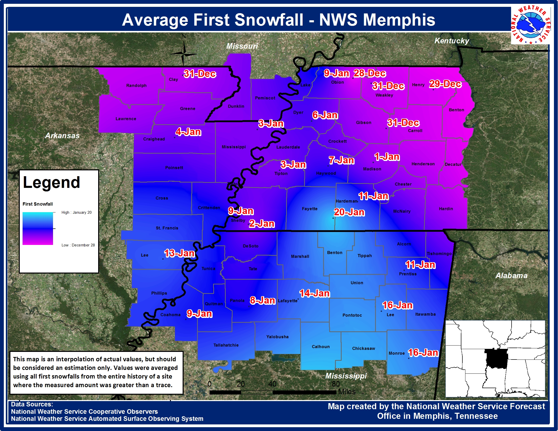
With the exception of Tupelo, all official sites recorded snowfall during the month of November, which is quite the anomaly, given that the average first snowfall for most locations is not until late December to early January (see the map at the end of this article). Jonesboro recorded the most snowfall this month with 0.3 inches, Memphis came in at 0.2 inches, while Jackson recorded 0.1 inches. Each of the three sites also recorded a trace of snow depth.
The month of November ranked in the top ten coolest months of November at all four official sites:
Memphis- 7th coolest on record (tied with the years 1877 and 1932)
Jackson- 2nd coolest on record
Jonesboro- 3rd coolest on record
Tupelo- 4th coolest on record
TEMPERATURE DATA:
Memphis Jackson Jonesboro Tupelo
Average Temperature (MONTH) : 47.4 44.1 44.2 46.8
Normal Avg. Temp (MONTH) : 53.2 50.1 49.6 52.9
Departure from Normal (MONTH): -5.8 -6.0 -5.4 -6.1
Average Temperature (YEAR) : 62.6 59.3 59.5 62.1
Normal Avg. Temp (YEAR) : 64.7 61.5 61.8 64.1
Departure from Normal (YEAR) : -2.1 -2.2 -2.3 -2.0
Maximum Temperature : 75.0 73.0 72.0 75.0
Minimum Temperature : 20.0 16.0 19.0 21.0
PRECIPITATION DATA:
Memphis Jackson Jonesboro Tupelo
Total Precipitation (MONTH) : 2.56 2.18 1.89 4.50
Normal Precipitation (MONTH) : 5.49 4.90 4.90 4.70
Departure from Normal (MONTH): -2.93 -2.72 -3.01 -0.20
Total Precipitation (YEAR) : 55.03 55.20 41.36 52.01
Normal Precipitation (YEAR) : 47.94 47.92 43.33 48.73
Departure from Normal (YEAR) : 7.09 7.28 -1.97 3.28
Percent of Normal : 115% 115% 95% 107%
SNOWFALL DATA:
Memphis Jackson Jonesboro Tupelo
Total Snowfall (MONTH) : 0.2 0.1 0.3 0.0
Normal Snowfall (MONTH) : 0.0 0.0 0.0 0.0
Departure from Normal (MONTH): 0.2 0.1 0.3 0.0
Greatest Snow Depth (MONTH) : Trace Trace Trace 0
Fall 2014 Review:
Meteorological fall witnessed slightly cooler than normal temperatures, and a mix of above normal, slightly below normal, and well below normal precipitation totals.
Jackson had the greatest temperature departure at 1.4 degrees cooler than normal, with Memphis close behind at 1.2 degrees below normal. Tupelo was 0.9 degrees cooler than normal this fall, while Jonesboro was only 0.8 degrees below normal. Tupelo was the wettest site and also the only site with a wetter than normal precipitation total at 3.81 inches above normal. Jackson was only 0.53 inches drier than normal, while Memphis was 1.25 inches below normal. Jonesboro was the driest site this fall and had the greatest departure from normal at 4.54 inches below.
TEMPERATURE DATA:
Memphis Jackson Jonesboro Tupelo
Average Temperature (Fall14) : 63.0 59.3 60.1 62.4
Normal Avg. Temp (Fall) : 64.2 60.7 60.9 63.3
Departure from Normal (Fall14): -1.2 -1.4 -0.8 -0.9
PRECIPITATION DATA:
Memphis Jackson Jonesboro Tupelo
Total Precipitation (Fall14) : 11.31 11.52 7.68 16.07
Normal Precipitation (Fall) : 12.56 12.05 12.22 12.26
Departure from Normal (Fall14): -1.25 -0.53 -4.54 3.81
Climate Outlook:
With meteorological winter already underway, many may be wondering what the winter months hold for the Mid-South. While the variability in precipitation makes it difficult to predict, we can make a fairly decent prediction at the expected temperatures in terms of their relationship (above, near, below) to normal. The El Nino Southern Oscillation (ENSO) is one indicator which allows us to predict seasonal temperatures, especially in the cool season when the effects of ENSO are most prominent due to the enhanced strength of the jet stream. Currently the Climate Prediction Center (CPC) has predicted a 58% chance of an El Nino, the warm phase of ENSO, for the winter months. Recently a local climate study was conducted on the impacts of ENSO on the Mid-South. Through this study it was found that the Mid-South has enhanced odds of cooler than normal temperatures during the winter months in an El Nino season. A weak El Nino this winter is a good indication that our temperatures could be slightly cooler than normal.
The Climate Prediction Center (CPC) has obviously considered ENSO when making its winter outlook, as it has given the Mid-South enhanced odds of experiencing below normal temperatures this winter. This is for the three month period of December, January, and February. In our local climate study we found that, on average, when a weak El Nino occurs winter temperatures are up to 1.2 degrees cooler than normal. As previously stated, precipitation values are harder to predict as they are much more variable than temperatures. Therefore the CPC has predicted an equal chance for precipitation this winter. This means there is no clear climate signal to indicate how wet or dry it may be.
Finally, for the month of December alone, the CPC has predicted slightly enhanced odds of above normal temperatures. In addition to the monthly and seasonal outlooks, the CPC also issues outlooks up to 14 days out. For the next couple of weeks, encompassing mid-December, the CPC is predicting enhanced odds of above normal temperatures. If this forecast holds up December average temperatures could be near or above normal, which would be quite the change from the abnormally cool November we experienced around the region. However, it would have to be several degrees above normal to turn around the below normal average temperatures for 2014.
MAYE
Average First Snowfall: