...MAY 2014 MONTHLY CLIMATE SUMMARY...
Near normal temperatures and below normal precipitation amounts were recorded during the month of May.
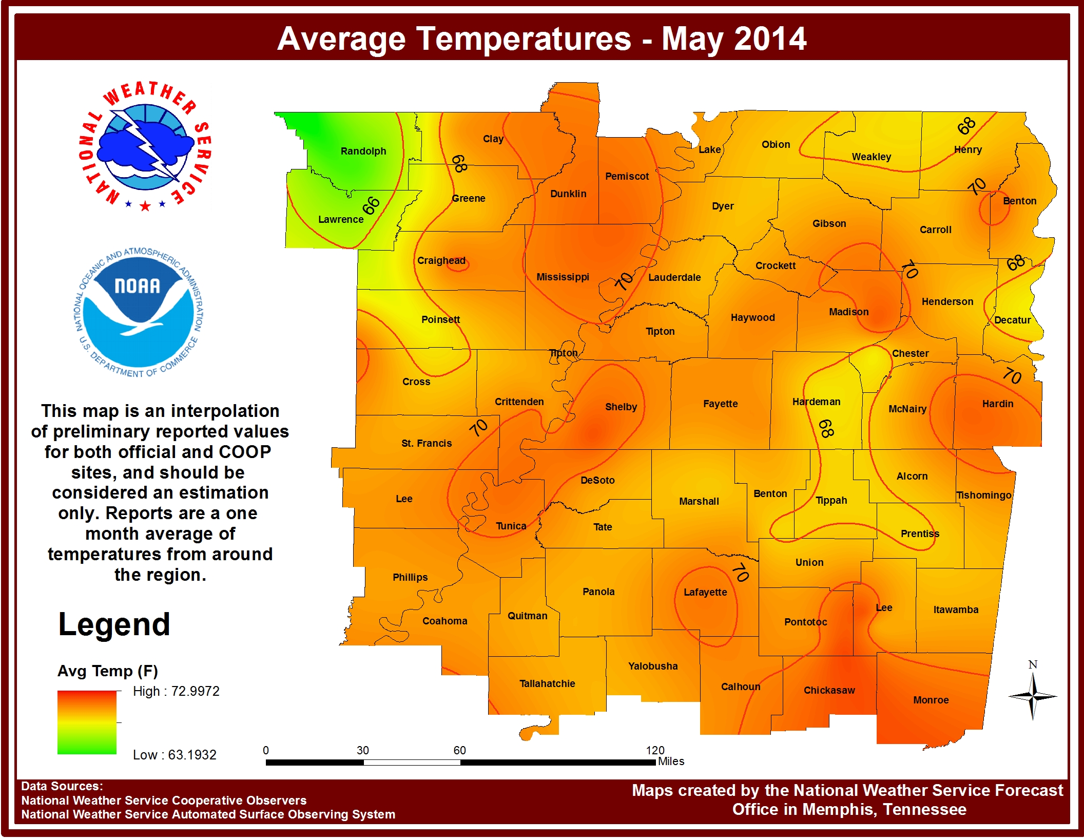
Memphis had the average temperature closest to normal, at only 0.3 degrees below normal, and was also the warmest of the four sites at 71.4 degrees. Despite being the warmest site, Memphis was the only site with a temperature departure that was below normal for the month of May. Overall for the year Memphis has an average temperature that is 3.1 degrees below normal. Tupelo was the second warmest site and was also the second closest site to normal, at only 0.6 degrees above normal. Currently for the year the average temperature at Tupelo is 2.9 degrees below normal. Jonesboro had an average temperature that was 0.9 degrees below normal for May, while Jackson was the coolest site and had an average temperature that was 1.1 degrees above normal. The current average temperature at Jonesboro for the year is 3.6 degrees below normal, the largest departure for the year of the sites, while Jackson is 2.9 degrees below its normal.
Memphis and Jackson are the only two official sites that have not yet reached 90 degrees this year. This puts both sites behind their average first date of 90 degrees, which is May 24th for Memphis and May 20th for Jackson. Historically, the latest recorded first date of 90 degrees for Memphis was on July 5th in 1907 and June 25th in 2003 for Jackson. Both Jonesboro and Tupelo hit 90 degrees this month, both occurring for the first time on May 24th. This was after the average first date which is May 19th for both sites.
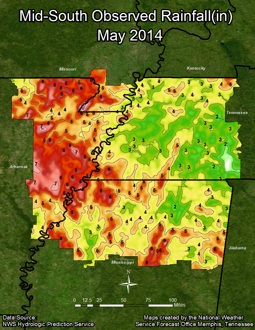
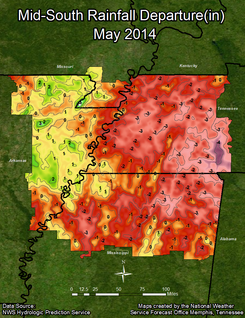
Parts of north Mississippi and west Tennessee have experienced D0 and D1 drought conditions over the past few months, and these conditions continue into the month of June as precipitation totals for Jackson and Tupelo were below normal for the month. In addition, Jackson and Tupelo are the only two sites with a below normal total on the year, with Tupelo at 4.42 inches below normal and Jackson at 1.53 inches below normal. All four sites had below normal precipitation totals for May, with Jonesboro receiving the most with 4.58 inches, only a 0.03 inch departure below normal. Currently Memphis is the only site for the year with a departure above normal, while Jonesboro is exactly at normal for the year. The following are the data which detail the climate of May and the year 2014 to date, with precipitation totals and departures graphics following the end of this summary.
TEMPERATURE DATA:
Memphis Jackson Jonesboro Tupelo
Average Temperature (MONTH) : 71.4 69.7 70.0 71.3
Normal Avg. Temp (MONTH) : 71.7 68.6 69.1 70.7
Departure from Normal (MONTH): -0.3 1.1 0.9 0.6
Average Temperature (YEAR) : 52.0 49.1 48.0 52.0
Normal Avg. Temp (YEAR) : 55.1 52.0 51.6 54.9
Departure from Normal (YEAR) : -3.1 -2.9 -3.6 -2.9
Maximum Temperature : 89.0 89.0 90.0 91.0
Minimum Temperature : 44.0 40.0 42.0 44.0
PRECIPITATION DATA:
Memphis Jackson Jonesboro Tupelo
Total Precipitation (MONTH) : 4.32 3.82 4.58 4.40
Normal Precipitation (MONTH) : 5.25 5.69 4.61 5.56
Departure from Normal (MONTH): -0.93 -1.87 -0.03 -1.16
Total Precipitation (YEAR) : 25.96 22.01 21.28 20.18
Normal Precipitation (YEAR) : 24.28 23.54 21.28 24.60
Departure from Normal (YEAR) : 1.68 -1.53 0.00 -4.42
Spring 2014 Review:
The end of May also marks the end of meteorological spring, which runs from March to May. This spring was cooler than normal for all four sites, with two sites having above normal amounts of precipitation and two sites having below normal amounts. Memphis was the warmest site this spring and had the greatest temperature departure from normal at 1.9 degrees below normal. Jonesboro actually tied this departure, despite being the coolest official site. Tupelo and Jackson were 1.5 degrees and 1.7 degrees below normal, respectively.
As previously mentioned, Jackson and Tupelo lie in regions that have been undergoing D0 and D1 drought conditions, and their precipitation amounts speak to this. Jackson had a 1.45 inch departure below its spring normal, while Tupelo had a 1.08 inch departure below normal. Memphis was the wettest site this spring, recording 17.84 inches of precipitation, which was 1.93 inches above the normal for spring, while Jonesboro received 16.57 inches of precipitation this spring, 2.44 inches above its spring normal.
Spring 2014 was tied for the 4th coolest spring on record in Jonesboro, it was the 7th coolest on record in Jackson, it tied for the 12th coolest in Tupelo, and it tied for the 22nd coolest in Memphis. Memphis typically has less impressive records because its climate history dates back much further than those of the other sites.
TEMPERATURE DATA:
Memphis Jackson Jonesboro Tupelo
Average Temperature(Spring 14) : 61.0 58.2 57.8 60.8
Normal Avg. Temp (Spring) : 62.9 59.9 59.7 62.3
Departure from Normal(Spring 14): -1.9 -1.7 -1.9 -1.5
PRECIPITATION DATA:
Memphis Jackson Jonesboro Tupelo
Total Precipitation(Spring 14) : 17.84 13.85 16.57 14.08
Normal Precipitation (Spring) : 15.91 15.30 14.13 15.16
Departure from Normal(Spring 14): 1.93 -1.45 2.44 -1.08
Climate Outlook:
For the month of June the Climate Prediction Center (CPC) is predicting an equal chance for temperatures. This means there is a 33 percent chance for temperatures that are above normal, 33 percent chance for normal, and 33 percent for below normal. This typically occurs when there is no clear climate signal to clearly define where temperatures may be for the month. For June precipitation the CPC has predicted a 40 percent chance of above normal amounts, a 33 percent chance of near normal amounts, and a 27 percent chance of below normal amounts. Above normal precipitation amounts would be beneficial for relieving some of the drought conditions in northeast Mississippi and west Tennessee.
Meteorological summer begins in June and covers the months of June, July, and August. For temperatures during this time period the CPC is currently predicting a 33 percent chance of above normal, 35 percent chance of near normal, and a 32 percent chance of below normal. Again this means there is no clear climate indicator for summer temperatures, so we cannot accurately assume or predict how warm temperatures may be. Unfortunately the same is true for precipitation during the summer months, thus no prediction can be made.
MAYE
Average temperatures for May 2014:
Precipitation graphics for May 2014: