...MAY 2013 MONTHLY CLIMATE SUMMARY...
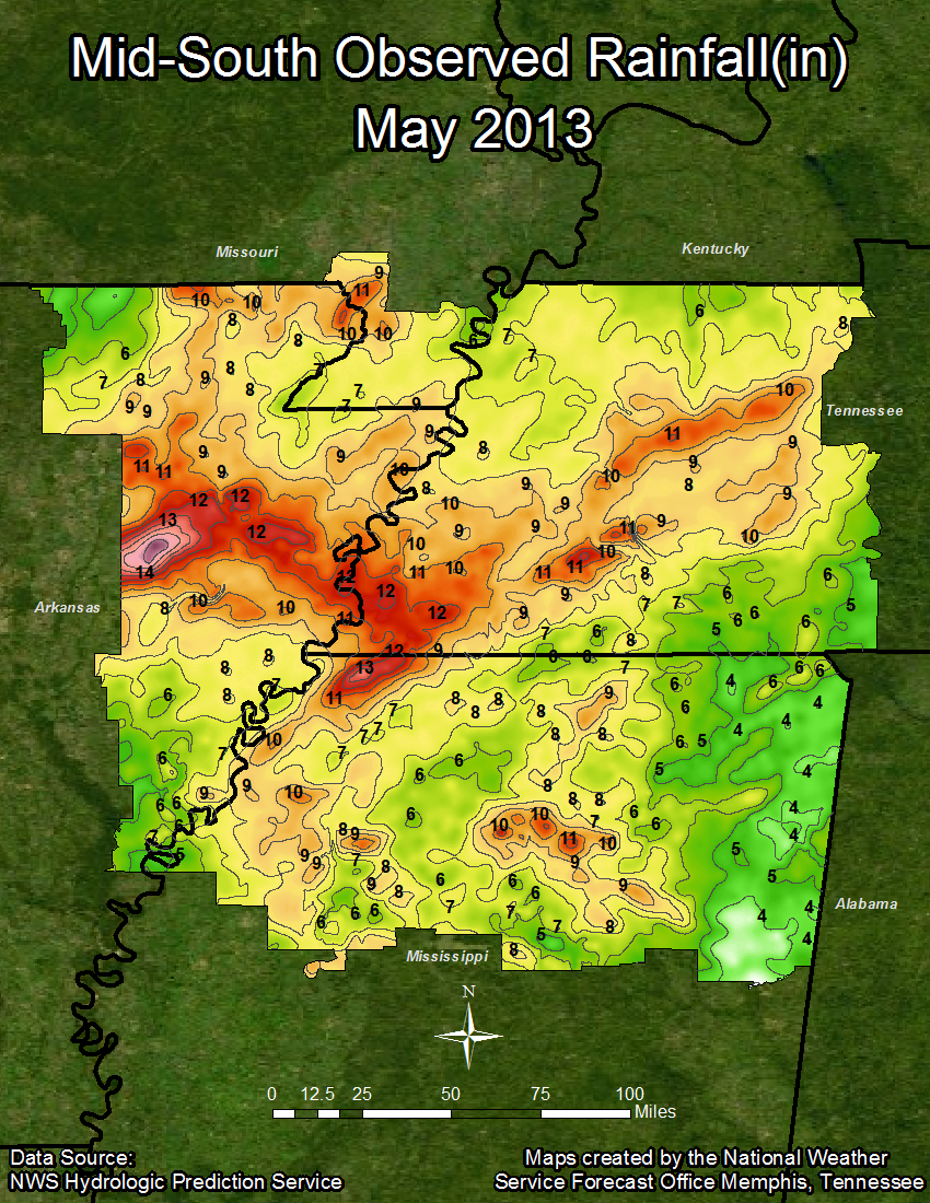
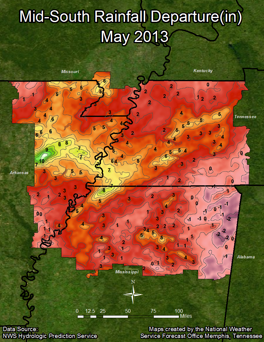
May in the Mid-South was cool and wet, keeping in line with April, which also saw below average temperatures and above average precipitation totals for the month. The average temperatures for Memphis, Jackson, and Tupelo were nearly two degrees below normal, while Jonesboro’s average temperature for the month was nearly a degree below normal. Memphis set the all-time low temperature for the month of May this year, recording 36 degrees on May 4th. Each of the other three sites broke at least one daily low temperature record during May, mainly during the first week of the month. The current average temperature for 2013 is in the lower 50s for each of the sites, bringing each around a degree below average for 2013 so far. Memphis was the warmest site this month, with an average temperature of 69.7 degrees, while Jackson was the coolest at 66.9 degrees.
In addition to being the warmest in May, Memphis was also the wettest site this month with 10.75 inches of precipitation, making May 2013 the fourth wettest May on record. Tupelo was the driest site this month with 6.49 inches of precipitation, but still managed to finish the month nearly an inch above the May normal, and nearly 4 inches above the normal precipitation for the year. Jackson is currently the wettest site for 2013 with nearly 35 inches of precipitation, which is just over 10 inches above normal. Jonesboro is the driest site so far in 2013, with just over 26 inches of precipitation.
Temperature Data:
Memphis Jackson Jonesboro Tupelo
Average Temperature (MAY) : 69.7 66.9 68.3 68.8
Normal Avg. Temp (MAY) : 71.7 68.6 69.1 70.7
Departure from Normal (MAY) : -2.0 -1.7 -0.8 -1.9
Average Temperature (2013) : 53.9 50.8 51.0 53.8
Normal Avg. Temp (YEAR) : 55.1 52.0 51.6 54.9
Departure from Normal (2013): -1.1 -1.3 -0.7 -1.0
Precipitation Data:
Memphis Jackson Jonesboro Tupelo
Total Precipitation (MAY) : 10.75 8.59 9.81 6.49
Normal Precipitation (MAY) : 5.25 5.69 4.61 5.56
Departure from Normal (MAY) : 5.50 2.90 5.20 0.93
Total Precipitation (2013) : 34.58 34.98 26.34 28.43
Normal Precipitation (YEAR) : 24.28 24.54 21.28 24.60
Departure from Normal (2013) : 10.30 10.44 5.06 3.83
Since May was abnormally wet around the Mid-South, the following is a list of the top ten wettest months of May. Listed in each list is rank (RNK), precipitation value in inches (IN), the year in which the record event occurred (YR), and the departure from normal, based upon the 1981-2010 set of normals.
Top 10 Wettest Months of May:
|
MEMPHIS |
JACKSON |
|||||||
|
RNK |
IN |
YR |
DEP |
RNK |
IN |
YR |
DEP |
|
|
1 |
13.34 |
1893 |
8.09 |
1 |
14.90 |
2010 |
9.21 |
|
|
2 |
11.58 |
1953 |
6.33 |
2 |
14.46 |
1974 |
8.77 |
|
|
3 |
11.40 |
2003 |
6.15 |
3 |
11.47 |
1983 |
5.78 |
|
|
4 |
10.75 |
2013 |
5.50 |
4 |
10.88 |
1978 |
5.19 |
|
|
5 |
9.58 |
1983 |
4.33 |
5 |
9.34 |
1967 |
3.65 |
|
|
6 |
9.26 |
2010 |
4.01 |
6 |
9.25 |
1991 |
3.56 |
|
|
7 |
9.14 |
1882 |
3.89 |
7 |
8.64 |
2009 |
2.95 |
|
|
8 |
9.06 |
1984 |
3.81 |
8 |
8.59 |
2013 |
2.90 |
|
|
9 |
8.88 |
1958 |
3.63 |
9 |
8.39 |
1979 |
2.70 |
|
|
10 |
8.72 |
1975 |
3.47 |
10 |
8.38 |
1984 |
2.69 |
|
|
JONESBORO |
TUPELO |
|||||||
|
RNK |
IN |
YR |
DEP |
RNK |
IN |
YR |
DEP |
|
|
1 |
10.62 |
1946 |
6.01 |
1 |
17.96 |
1978 |
12.4 |
|
|
2 |
9.98 |
1973 |
5.37 |
2 |
17.56 |
1991 |
12 |
|
|
2 |
9.98 |
2003 |
5.37 |
3 |
11.08 |
1974 |
5.52 |
|
|
4 |
9.88 |
1957 |
5.27 |
4 |
10.42 |
2010 |
4.86 |
|
|
5 |
9.81 |
2013 |
5.2 |
5 |
10.35 |
1983 |
4.79 |
|
|
6 |
9.48 |
2011 |
4.87 |
6 |
9.89 |
1979 |
4.33 |
|
|
7 |
9.34 |
1920 |
4.73 |
7 |
9.85 |
2003 |
4.29 |
|
|
8 |
8.84 |
1983 |
4.23 |
8 |
9.8 |
1955 |
4.24 |
|
|
9 |
8.59 |
1978 |
3.98 |
9 |
9.65 |
2009 |
4.09 |
|
|
10 |
8.35 |
2009 |
3.74 |
10 |
8.44 |
1984 |
2.88 |
|
Monthly Weather Synopsis:
May began cool and rainy as a strong upper level disturbance and associated cold front brought heavy rain to the area, as well as the all-time record low temperature for Memphis during May. The second week and weekend of the month witnessed more rain and below average temperatures, leading to more record breaking low temperatures across the Mid-South. The night of Sunday, May 12th saw a daily record low for Jackson (38), breaking the previous record of 43 set back in 1960. That same night Tupelo tied the 1997 daily record low of 43 after a cold front and secondary cold front moved through the area. Ahead of the cold front, heavy rain caused flash flooding to occur in Carroll County on Friday, May 10th. After the front passed through the area, high pressure built across the area and dominated as normal temperatures for May returned. Several upper level disturbances during the month contributed to the above average precipitation totals.
A low pressure system moved across the Lower Mississippi River Valley on Tuesday, May 21st, bringing severe weather to the area. Damaging winds, hail, and flash flooding were the primary threats during the event. Following this low pressure system, an upper level ridge of high pressure built over the area, providing warmer temperatures and humid conditions for the Memorial Day weekend. Another round of thunderstorms associated with a shortwave moved through the area on the evening of May 30th and the morning of May 31st. A storm on May 30th brought wind damage to areas from northern Mississippi to northern west Tennessee. Winds up to 80 MPH were estimated near Jackson, TN, damaging a barn and an outbuilding, bringing down many trees and tree limbs, and causing power outages. Hail up to quarter size was also reported with this storm. During the morning hours on May 31st, another line of thunderstorms moved across the area, producing an EF1 tornado to the northwest of Covington, TN in Tipton County. This tornado had an estimated peak wind of 95 miles an hour, lasted about four minutes, and left a damage path about 250 yards wide and 1.3 miles long. In the end two houses were significantly damaged and a shop was completely destroyed, along with many downed trees and limbs.
MAYE

