
Public Information Statement
National Weather Service Memphis TN
811 PM CDT Wed Apr 5 2023
......NWS Damage Survey for March 31 and April 1 Tornado Outbreak -
Update #3...
.Update...Width of Benton County tornado corrected.
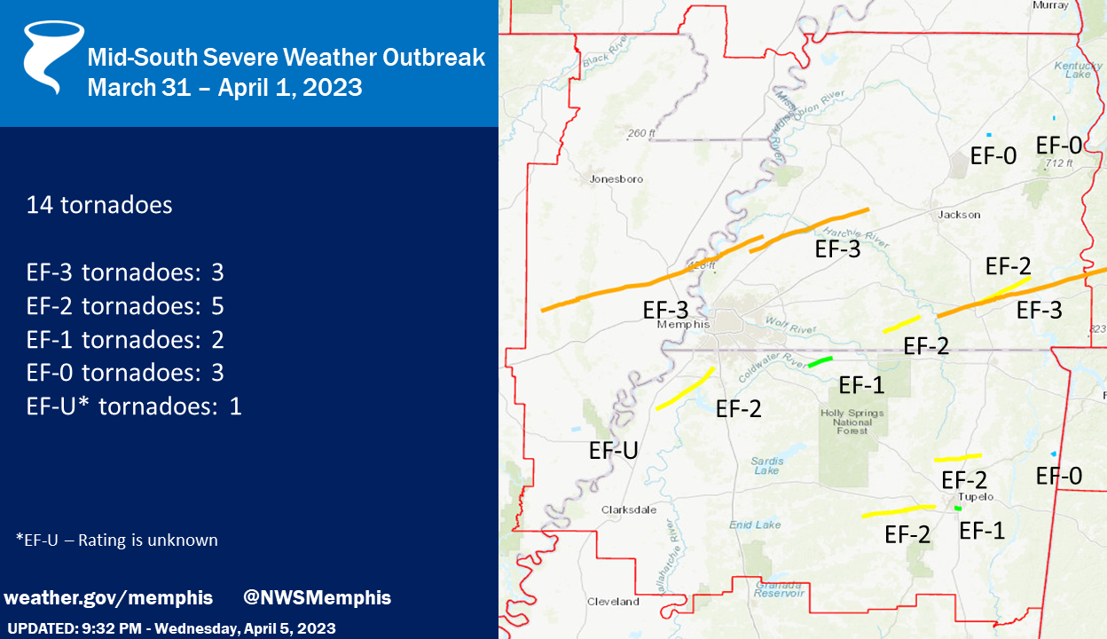
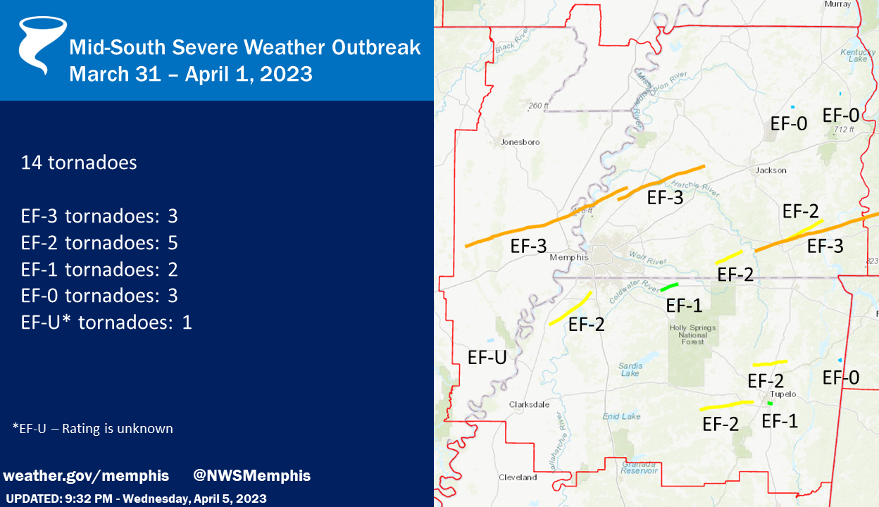
.Fourteen tornadoes have been confirmed across the Mid-South from
the severe weather event on March 31 and April 1.
EF-3 tornadoes: 3
EF-2 tornadoes: 5
EF-1 tornadoes: 2
EF-0 tornadoes: 3
EF-U tornadoes: 1
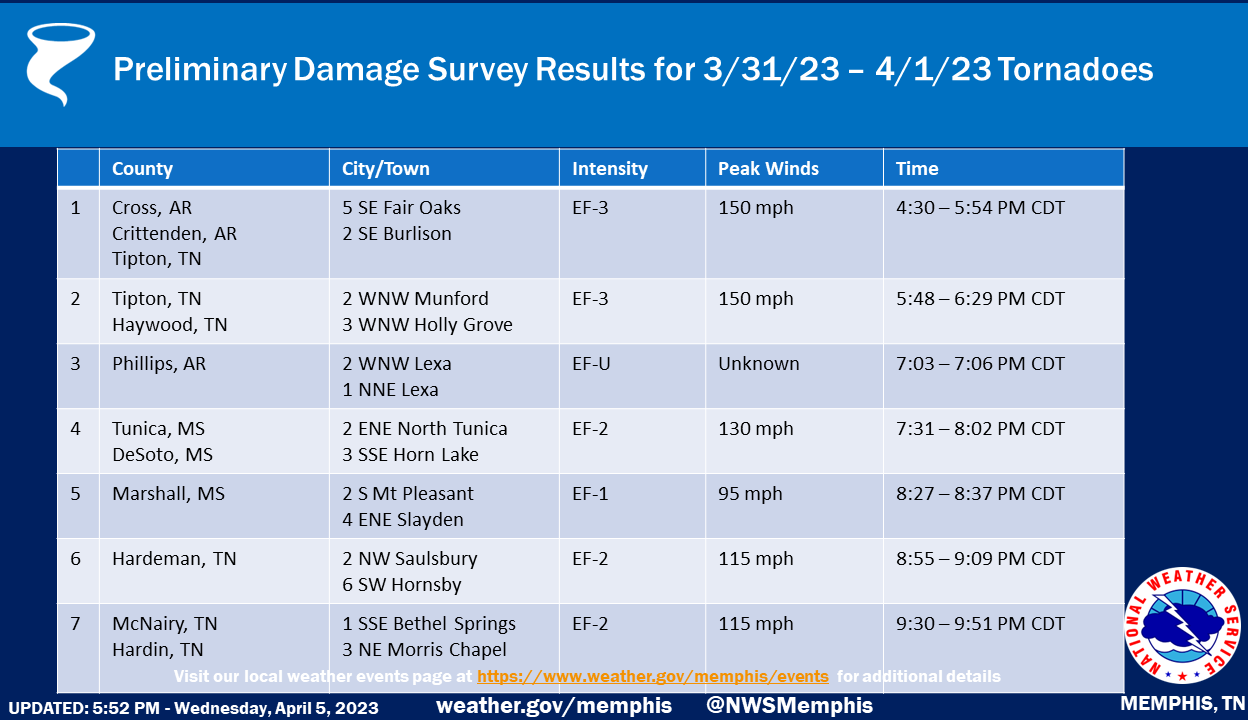
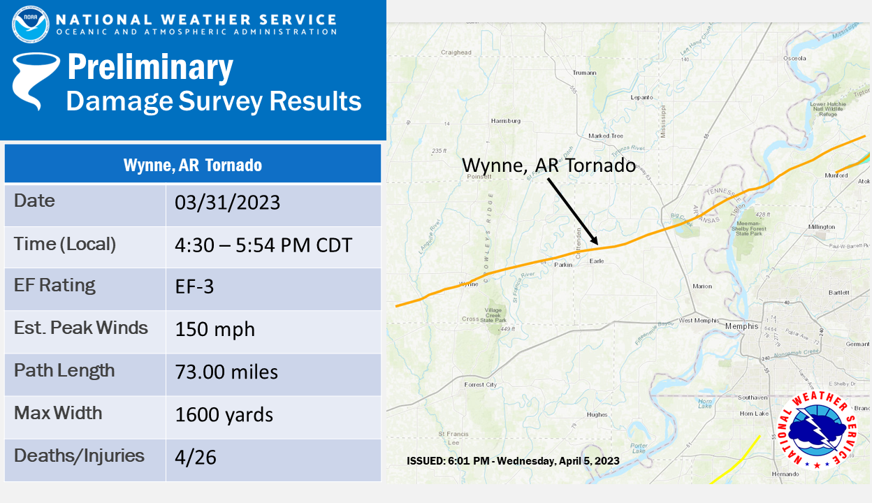 .Wynne Tornado...
Rating: EF3
Estimated Peak Wind: 150 mph
Path Length /statute/: 73.00 miles
Path Width /maximum/: 1600 yards
Fatalities: 4
Injuries: 26
Start Date: 03/31/2023
Start Time: 04:30 PM CDT
Start Location: 5 SE Fair Oaks / Cross County / AR
Start Lat/Lon: 35.1818 / -90.9615
End Date: 03/31/2023
End Time: 05:54 PM CDT
End Location: 2 SE Burlison / Tipton County / TN
End Lat/Lon: 35.5392 / -89.7552
Survey Summary:
NWS meteorologists determined an EF-3 tornado touched down in
western Cross County at 431 PM CDT on March 31 on County Road
537, just south of Highway 284. The tornado tracked to the east
northeast towards Wynne, AR where it crossed Highway 284 multiple
times. EF-2 damage was observed north of Ellis Chapel and
McElroy. Just east northeast of McElroy, significant EF-2 damage
of the Sewage Treatment Plant was noted where an 80-yard long
shed with sturdy roofing structure of metal failed and became
aloft. The roofing wadded up and destroyed 2 cinder block
buildings before landing 100 yards away. The tornado strengthened
to an EF-3 as it moved into west Wynne, AR where it ravaged the
center of Wynne, including the Wynne High School. Several one-
and two-family residences in Wynne were partially to completely
destroyed.
The tornado weakened as it moved away from Wynne to north of
Parkin and Earle, AR where EF-2 damage was observed. Between
Earle, AR and the Mississippi River, very few damage indicators
aided in the observed strength as it traversed mostly farmland.
There were between 20 to 30 center pivot irrigation systems that
were overturned along this area. As the tornado passed over Corna
Lake in Tipton County (west side of the Mississippi River) and
extreme southern Mississippi County, EF- 3 damage was observed.
The tornado crossed the Mississippi River and into Tipton County,
TN where it produced EF-2 damage across Wilder Farms. As the
tornado climbed the Bluff, the tornado circulation began to
weaken. From the top of the Bluff at the intersection of Pryor and
Leach Roads to south of Burlison where the tornado appears to
have lifted, EF-1 and EF-0 damage was observed. It is important to
note that as the long-tracked Wynne, AR tornado was dissipating,
the Covington, TN tornado was on the ground approximately 3.5
miles away to the south.
.Wynne Tornado...

Rating:                 EF3
Estimated Peak Wind:    150 mph
Path Length /statute/:  73.00 miles
Path Width /maximum/:   1600 yards
Fatalities:             4
Injuries:               26

Start Date:             03/31/2023
Start Time:             04:30 PM CDT
Start Location:         5 SE Fair Oaks / Cross County / AR
Start Lat/Lon:          35.1818 / -90.9615

End Date:               03/31/2023
End Time:               05:54 PM CDT
End Location:           2 SE Burlison / Tipton County / TN
End Lat/Lon:            35.5392 / -89.7552

Survey Summary:
NWS meteorologists determined an EF-3 tornado touched down in
western Cross County at 431 PM CDT on March 31 on County Road
537, just south of Highway 284. The tornado tracked to the east
northeast towards Wynne, AR where it crossed Highway 284 multiple
times. EF-2 damage was observed north of Ellis Chapel and
McElroy. Just east northeast of McElroy, significant EF-2 damage
of the Sewage Treatment Plant was noted where an 80-yard long
shed with sturdy roofing structure of metal failed and became
aloft. The roofing wadded up and destroyed 2 cinder block
buildings before landing 100 yards away. The tornado strengthened
to an EF-3 as it moved into west Wynne, AR where it ravaged the
center of Wynne, including the Wynne High School. Several one-
and two-family residences in Wynne were partially to completely
destroyed.

The tornado weakened as it moved away from Wynne to north of
Parkin and Earle, AR where EF-2 damage was observed. Between
Earle, AR and the Mississippi River, very few damage indicators
aided in the observed strength as it traversed mostly farmland.
There were between 20 to 30 center pivot irrigation systems that
were overturned along this area. As the tornado passed over Corna
Lake in Tipton County (west side of the Mississippi River) and
extreme southern Mississippi County, EF- 3 damage was observed.
The tornado crossed the Mississippi River and into Tipton County,
TN where it produced EF-2 damage across Wilder Farms. As the
tornado climbed the Bluff, the tornado circulation began to
weaken. From the top of the Bluff at the intersection of Pryor and
Leach Roads to south of Burlison where the tornado appears to
have lifted, EF-1 and EF-0 damage was observed. It is important to
note that as the long-tracked Wynne, AR tornado was dissipating,
the Covington, TN tornado was on the ground approximately 3.5
miles away to the south.
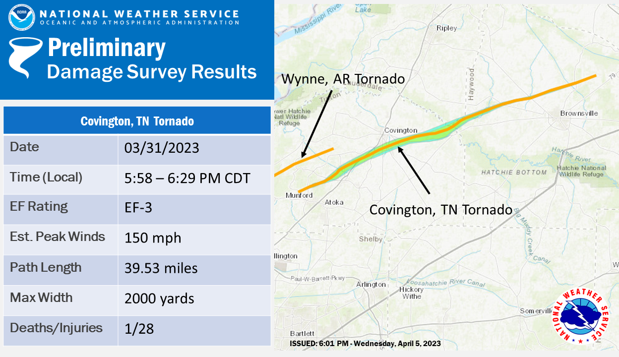
.Covington Tornado...

Rating:                 EF3
Estimated Peak Wind:    150 mph
Path Length /statute/:  39.53 miles
Path Width /maximum/:   2000 yards
Fatalities:             1
Injuries:               28

Start Date:             03/31/2023
Start Time:             05:48 PM CDT
Start Location:         2 WNW Munford / Tipton County / TN
Start Lat/Lon:          35.4621 / -89.8323

End Date:               03/31/2023
End Time:               06:29 PM CDT
End Location:           3 WNW Holly Grove / Haywood County / TN
End Lat/Lon:            35.6696 / -89.1838

Survey Summary:
The tornado developed along Highway 178 just northwest of
Munford. A few fences were damaged in this area and small tree
limbs were snapped. The tornado traveled east-northeast and
damaged farm outbuildings along Beaver Road and then uprooted and
snapped trees along Walker Field Road and Walker Field Lane. The
tornado then crossed Cattle Branch Creek causing minor tree
damage. The first structural damage occurred along Laxton Lane
and Fite Road where houses had some minor roof damage. The
tornado began to intensify as it crossed Akins Road and
approached Marshall Drive. A few power poles were broken in this
area. The first EF-3 damage occurred along Myron Creek Drive
where significant structural damage occurred to a couple of well-
built homes. The tornado crossed Indian Creek Canal and continued
to cause major damage to homes and trees along Indian Creek Road
and Wright Lane. The lone fatality of the tornado occurred in
this area.

The tornado continued east-northeast toward Highway 51, where it
damaged trees and structures along Jack Bennett and Liberty Church
Smith Road. The tornado widened to over one-half mile wide as it
approached and crossed Highway 51. Several homes were completely
destroyed in this area and dozens of homes had significant damage.
Several businesses along Highway 51 suffered heavy damage. EF-3
damage was widespread in this area. Fifty- three power poles had
to be replaced along Highway 51 south of Covington. The tornado
then moved across the southern section of Covington. This area is
mostly industrial and several businesses suffered significant
damage along Highways 59 and 384. A metal truss tower was crumpled
to the ground. The tornado damaged the middle and elementary
schools along Mark Walker Jr. Drive where the elementary school
suffered major damage to the gymnasium and several walls. The
tornado then crossed South Main Street and Highway 179 damaging
several more houses. Substantial damage was caused to several
houses along Highway 54. One house was completely destroyed and a
couple of large metal power poles were bent to the ground. The
tornado widened to almost a mile as it tracked east-northeast just
north of Highway 54. This area is rural and the last major
structural damage in Tipton County was on Lindsey Road where a
home suffered major roof damage.

The strong tornado continued tracking east-northeast taking out
several large metal power poles and snapping trees between farm
fields. Several irrigation pivots were overturned and twisted. The
tornado began to weaken across northeast Tipton County as it
tracked toward the Hatchie River. The tornado continued into
Haywood County causing significant tree damage along Estes Lane. A
mobile home suffered significant damage along Fulton Road. Minor
tree damage continued for a few more miles and then the tornado
lifted north of Brownsville. Minor damage was observed on
Gillespie Road and Highway 54 North with the tornado lifting just
east of Sturdivant Road.
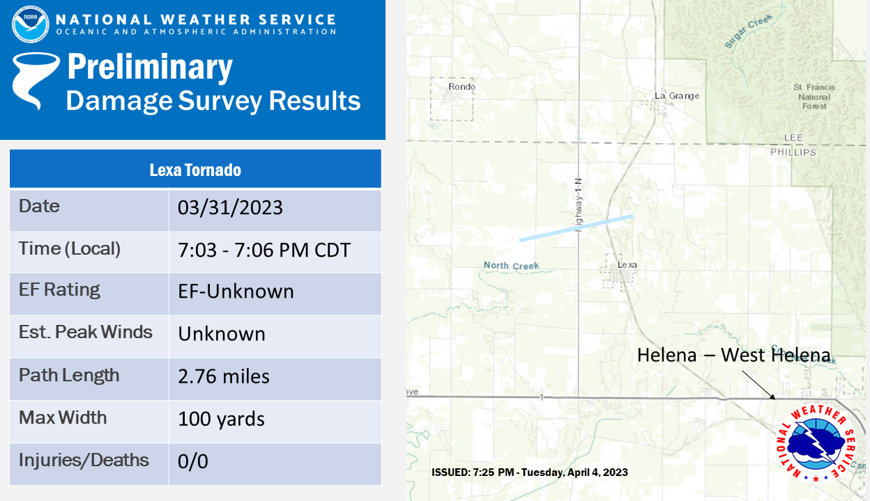
.Lexa Tornado...

Rating:                 EF-Unknown
Estimated Peak Wind:    UNKN
Path Length /statute/:  2.76 miles
Path Width /maximum/:   100 yards
Fatalities:             0
Injuries:               0

Start Date:             03/31/2023
Start Time:             07:03 PM CDT
Start Location:         2 WNW Lexa / Phillips County / AR
Start Lat/Lon:          34.6089 / -90.7929

End Date:               03/31/2023
End Time:               07:06 PM CDT
End Location:           1 NNE Lexa / Phillips County / AR
End Lat/Lon:            34.6174 / -90.7455

Survey Summary:
A funnel cloud which moved over much of Phillips County touched
down as a tornado briefly northwest of Lexa as it crosses Highway
1. An emergency manager along with several public spotters
observed the tornado briefly touching down over open fields. No
damage indicators were found and thus the tornado is rated as an
EF-U.  Nearby reports of damage were from straight line winds
that were associated with the same storm`s rear-flank downdraft.A
special thanks goes out to Phillips County Emergency Management
for their assistance during this survey.
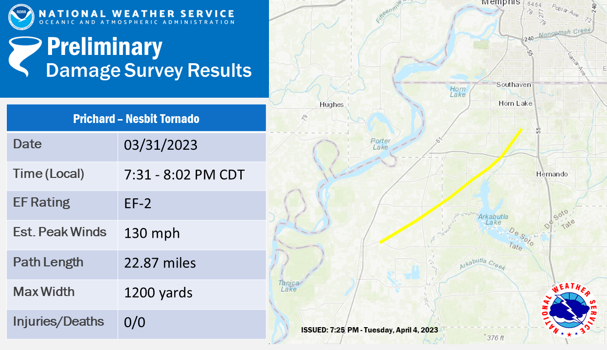
.Prichard-Nesbit Tornado...

Rating:                 EF2
Estimated Peak Wind:    130 mph
Path Length /statute/:  22.87 miles
Path Width /maximum/:   1200 yards
Fatalities:             0
Injuries:               0

Start Date:             03/31/2023
Start Time:             07:31 PM CDT
Start Location:         2 ENE North Tunica / Tunica County / MS
Start Lat/Lon:          34.7066 / -90.3381

End Date:               03/31/2023
End Time:               08:02 PM CDT
End Location:           3 SSE Horn Lake / DeSoto County / MS
End Lat/Lon:            34.911 / -90.026

Survey Summary:
A tornado formed just northeast of the Tunica airport and tracked
northeast through rural Tunica and Desoto counties. A large
number of homes and a church a few miles northeast of the airport
suffered roof damage. Several sheds were displaced and destroyed.
There was consistent damage for over 20 miles, mainly snapped and
uprooted trees. A few homes and mobile homes along highway
3 south of Arkabutla Dam Road had shingles remove or portions of
the metal roofing lifted. There were a number of trees snapped
and uprooted along Highway 3 and in a wooded area along Woffolk
Road. Several power poles were snapped and numerous trees along
Arkabutla Dam Road near the Desoto County line. The roof was
removed from a garage/carport. A couple other nearby homes
received roof damage. Near Cub Lake and Koko Reef Lake
communities, there was widespread tree damage, where numerous
homes were damaged or destroyed by falling trees. Tree damage in
the area was extensive. Near W Oak Grove and Highway 301 S, there
was significant tree damage, with a concentrated section of
snapped trees. A small area of EF2 damage was found north of West
Commerce Street between Baldwin and Fogg Roads. Shingles were
removed from several houses and mobile homes. The tornado path
continued northeast before dissipating in a wooded area southwest
of Nesbit.
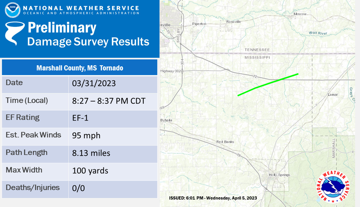 .Marshall County Tornado...
Rating: EF1
Estimated Peak Wind: 95 mph
Path Length /statute/: 8.13 miles
Path Width /maximum/: 100 yards
Fatalities: 0
Injuries: 0
Start Date: 03/31/2023
Start Time: 08:27 PM CDT
Start Location: 2 S Mt Pleasant / Marshall County / MS
Start Lat/Lon: 34.9168 / -89.5176
End Date: 03/31/2023
End Time: 08:37 PM CDT
End Location: 4 ENE Slayden / Marshall County / MS
End Lat/Lon: 34.9569 / -89.3831
Survey Summary:
NWS meteorologists determined an EF-1 tornado touched down in
northern Marshall County on the evening of March 31st. The first
evidence of tree damage occurred near Anderson Lane west of
Highway 311. The tornado continued to the northeast and crossed
Highway 311 where hardwood trees were snapped. Additional
hardwood tree damage was noted on Hogan Road and South Slayden
Road. The tornado crossed Highway 72 with hardwood trees snapped
on both sides of the highway. A single family residence on
Kennedy Road sustained roof damage with hardwood trees uprooted
on the property. The last evidence of damage was on Early Grove
Road where a few trees were uprooted. The tornado dissipated in a
field to the northeast of this location.
.Marshall County Tornado...

Rating:                 EF1
Estimated Peak Wind:    95 mph
Path Length /statute/:  8.13 miles
Path Width /maximum/:   100 yards
Fatalities:             0
Injuries:               0

Start Date:             03/31/2023
Start Time:             08:27 PM CDT
Start Location:         2 S Mt Pleasant / Marshall County / MS
Start Lat/Lon:          34.9168 / -89.5176

End Date:               03/31/2023
End Time:               08:37 PM CDT
End Location:           4 ENE Slayden / Marshall County / MS
End Lat/Lon:            34.9569 / -89.3831

Survey Summary:
NWS meteorologists determined an EF-1 tornado touched down in
northern Marshall County on the evening of March 31st. The first
evidence of tree damage occurred near Anderson Lane west of
Highway 311. The tornado continued to the northeast and crossed
Highway 311 where hardwood trees were snapped. Additional
hardwood tree damage was noted on Hogan Road and South Slayden
Road. The tornado crossed Highway 72 with hardwood trees snapped
on both sides of the highway. A single family residence on
Kennedy Road sustained roof damage with hardwood trees uprooted
on the property. The last evidence of damage was on Early Grove
Road where a few trees were uprooted. The tornado dissipated in a
field to the northeast of this location.
 .Hardeman County Tornado...
Rating: EF2
Estimated Peak Wind: 115 mph
Path Length /statute/: 12.78 miles
Path Width /maximum/: 450 yards
Fatalities: 0
Injuries: 0
Start Date: 03/31/2023
Start Time: 08:55 PM CDT
Start Location: 2 NW Saulsbury / Hardeman County / TN
Start Lat/Lon: 35.0767 / -89.1092
End Date: 03/31/2023
End Time: 09:09 PM CDT
End Location: 6 SW Hornsby / Hardeman County / TN
End Lat/Lon: 35.16 / -88.9097
Survey Summary:
Another tornado touched down near Grand Junction in southwest
Hardeman County, TN on Westfork Road around 855 PM CDT Friday
evening, March 31, 2023. This tornado produced an EF-1 swath of
tree damage as it traveled to the northeast, uprooting and
snapping the trunks of several large trees along Van Buren Road.
The damage swath broadened out quite a bit as it reached
Evergreen Road, causing more widespread and significant tree
damage to Saulsbury Road and Roger Springs Road where EF-2 tree
damage was noted. This tree damage continued for another few
miles to the northeast where significant roof damage occurred to
a one family residence on Callahan Road. EF-1 damage was observed
for several miles to the northeast along Sain Road. The tornado
tracked through Lone Oak Farm along Lake Hardeman Road causing
additional widespread tree damage. The tornado crossed Highway
125 damaging more trees before lifting just beyond L Crisp Road
in a wooded area.
.Hardeman County Tornado...

Rating:                 EF2
Estimated Peak Wind:    115 mph
Path Length /statute/:  12.78 miles
Path Width /maximum/:   450 yards
Fatalities:             0
Injuries:               0

Start Date:             03/31/2023
Start Time:             08:55 PM CDT
Start Location:         2 NW Saulsbury / Hardeman County / TN
Start Lat/Lon:          35.0767 / -89.1092

End Date:               03/31/2023
End Time:               09:09 PM CDT
End Location:           6 SW Hornsby / Hardeman County / TN
End Lat/Lon:            35.16 / -88.9097

Survey Summary:
Another tornado touched down near Grand Junction in southwest
Hardeman County, TN on Westfork Road around 855 PM CDT Friday
evening, March 31, 2023. This tornado produced an EF-1 swath of
tree damage as it traveled to the northeast, uprooting and
snapping the trunks of several large trees along Van Buren Road.
The damage swath broadened out quite a bit as it reached
Evergreen Road, causing more widespread and significant tree
damage to Saulsbury Road and Roger Springs Road where EF-2 tree
damage was noted. This tree damage continued for another few
miles to the northeast where significant roof damage occurred to
a one family residence on Callahan Road. EF-1 damage was observed
for several miles to the northeast along Sain Road. The tornado
tracked through Lone Oak Farm along Lake Hardeman Road causing
additional widespread tree damage. The tornado crossed Highway
125 damaging more trees before lifting just beyond L Crisp Road
in a wooded area.
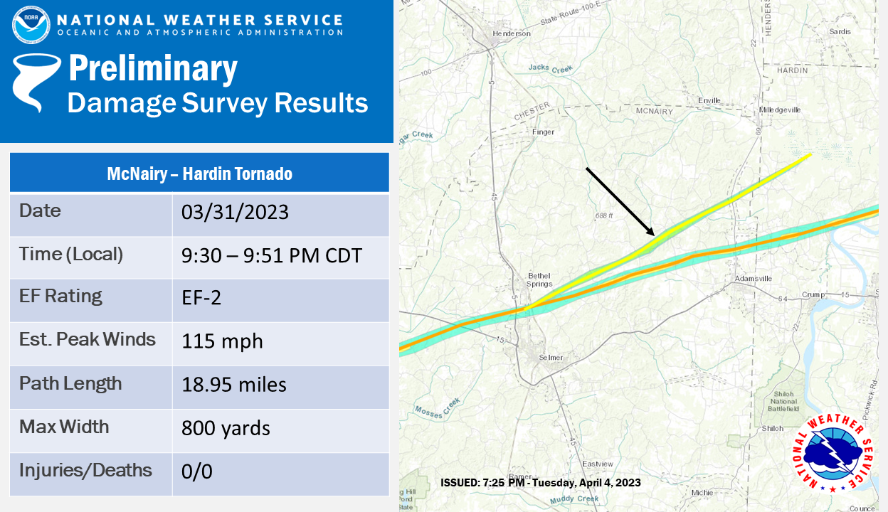
.McNairy-Hardin Tornado...

Rating:                 EF2
Estimated Peak Wind:    115 mph
Path Length /statute/:  18.95 miles
Path Width /maximum/:   800 yards
Fatalities:             0
Injuries:               0

Start Date:             03/31/2023
Start Time:             09:30 PM CDT
Start Location:         1 SSE Bethel Springs / McNairy County / TN
Start Lat/Lon:          35.2128 / -88.6067

End Date:               03/31/2023
End Time:               09:51 PM CDT
End Location:           3 NE Morris Chapel / Hardin County / TN
End Lat/Lon:            35.3432 / -88.3119

Survey Summary:
NWS damage surveys concluded that a tornado touched down just
south of Bethel Springs on Main Street around 9:30 PM CDT on the
evening of March 31, 2023. The tornado picked up in size and
intensity as it moved northeast toward Murray School Road where a
double-wide manufactured home was completely destroyed. EF-
2 damage continued northeast on Bethel Purdy Road where wooden
power poles were snapped. A nearly 5 mile long swath of EF-
1 damage was noted up through Good Hope Church Road where more
structures were significantly damaged. EF-2 damage was observed
at several locations off Good Hope Church Road, including
significant roof damage to a single family residence along with
bent metal electrical transmission poles. Widespread tree damage
continued for 10 miles to the northeast consistent with EF-1 wind
ratings. One last area of EF-2 damage was observed at Morris
Chapel Methodist Church, with significant roof damage and the
collapse of an exterior wall. The tornado dissipated in a field
just south of White Oak Creek Canal a few miles to the northeast
around 9:51 PM CDT.
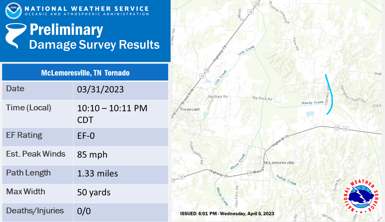 .McLemoresville Tornado...
Rating: EF0
Estimated Peak Wind: 85 mph
Path Length /statute/: 1.33 miles
Path Width /maximum/: 50 yards
Fatalities: 0
Injuries: 0
Start Date: 03/31/2023
Start Time: 10:10 PM CDT
Start Location: 3 NE McLemoresville / Carroll County / TN
Start Lat/Lon: 36.0098 / -88.5391
End Date: 03/31/2023
End Time: 10:11 PM CDT
End Location: 3 NNE McLemoresville / Carroll County / TN
End Lat/Lon: 36.028 / -88.5397
Survey Summary:
A tornado briefly touched down off of US-70 along Highway 436. It
ripped a few shingles off of a single family home and then went
on to down large limbs on trees. An occlusion led to the
northward motion of the tornado as it damaged another roof of a
home and then led to the major loss of roof panels to a small
metal outbuilding before lifting. A special thanks goes out to
Carroll County Emergency Management for their assistance in
locating damage on the survey.
.McLemoresville Tornado...

Rating:                 EF0
Estimated Peak Wind:    85 mph
Path Length /statute/:  1.33 miles
Path Width /maximum/:   50 yards
Fatalities:             0
Injuries:               0

Start Date:             03/31/2023
Start Time:             10:10 PM CDT
Start Location:         3 NE McLemoresville / Carroll County / TN
Start Lat/Lon:          36.0098 / -88.5391

End Date:               03/31/2023
End Time:               10:11 PM CDT
End Location:           3 NNE McLemoresville / Carroll County / TN
End Lat/Lon:            36.028 / -88.5397

Survey Summary:
A tornado briefly touched down off of US-70 along Highway 436. It
ripped a few shingles off of a single family home and then went
on to down large limbs on trees. An occlusion led to the
northward motion of the tornado as it damaged another roof of a
home and then led to the major loss of roof panels to a small
metal outbuilding before lifting.  A special thanks goes out to
Carroll County Emergency Management for their assistance in
locating damage on the survey.
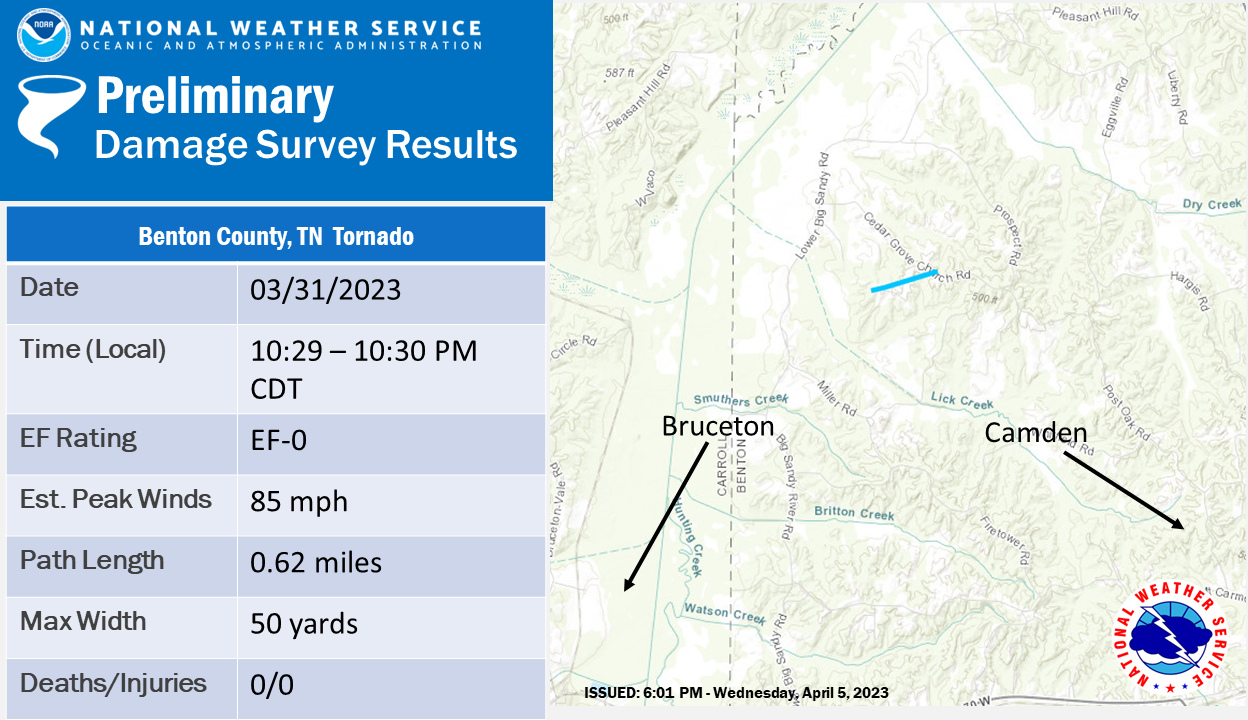 .Benton County Tornado...
Rating: EF0
Estimated Peak Wind: 85 mph
Path Length /statute/: 0.62 miles
Path Width /maximum/: 50 yards
Fatalities: 0
Injuries: 0
Start Date: 03/31/2023
Start Time: 10:29 PM CDT
Start Location: 4 ESE Vale / Benton County / TN
Start Lat/Lon: 36.0984 / -88.1905
End Date: 03/31/2023
End Time: 10:30 PM CDT
End Location: 5 WNW Camden / Benton County / TN
End Lat/Lon: 36.1009 / -88.1798
Survey Summary:
A tornado briefly touched down along an elevated area and led to
the collapse of walls and removal of much of the roof of a metal
outbuilding along Sawmill Rd. The tornado also damaged branches
on a couple of trees nearby the outbuilding, lifted briefly, and
then down more limbs along Cedar Grove Church Road. While the
damage path was short-lived in duration, it was determined to be
tornadic based on the convergent damage pattern and vertical lift
of roof panels into trees behind the outbuilding. A special goes
out to Benton County Emergency Management for their assistance in
locating damage during the survey.
.Benton County Tornado...

Rating:                 EF0
Estimated Peak Wind:    85 mph
Path Length /statute/:  0.62 miles
Path Width /maximum/:   50 yards
Fatalities:             0
Injuries:               0

Start Date:             03/31/2023
Start Time:             10:29 PM CDT
Start Location:         4 ESE Vale / Benton County / TN
Start Lat/Lon:          36.0984 / -88.1905

End Date:               03/31/2023
End Time:               10:30 PM CDT
End Location:           5 WNW Camden / Benton County / TN
End Lat/Lon:            36.1009 / -88.1798

Survey Summary:
A tornado briefly touched down along an elevated area and led to
the collapse of walls and removal of much of the roof of a metal
outbuilding along Sawmill Rd. The tornado also damaged branches
on a couple of trees nearby the outbuilding, lifted briefly, and
then down more limbs along Cedar Grove Church Road. While the
damage path was short-lived in duration, it was determined to be
tornadic based on the convergent damage pattern and vertical lift
of roof panels into trees behind the outbuilding. A special goes
out to Benton County Emergency Management for their assistance in
locating damage during the survey.
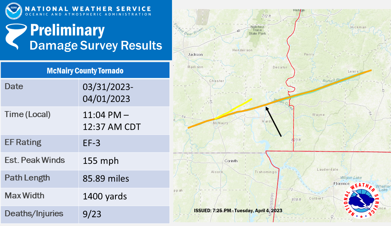
.McNairy County Tornado...

Rating:                 EF3
Estimated Peak Wind:    155 mph
Path Length /statute/:  85.90 miles
Path Width /maximum/:   1400 yards
Fatalities:             9
Injuries:               23

Start Date:             03/31/2023
Start Time:             11:04 PM CDT
Start Location:         5 SSE Hornsby / Hardeman County / TN
Start Lat/Lon:          35.1559 / -88.8175

End Date:               04/01/2023
End Time:               12:37 AM CDT
End Location:           10 WSW Mount Pleasant / Lewis County / TN
End Lat/Lon:            35.5278 / -87.3681

Survey Summary:
The tornado formed in far eastern Hardeman County just to the
east of Muddy Creek, causing damage to trees and minor structural
damage along Powell Chapel and Skipper Creek Roads. This tornado
moved east-northeast along Skipper Creek, intensifying as it
moved into the Rose Creek area. A swath of significant damage was
surveyed along Rose Creek road from Talley Road to King Road.
Tree damage was widespread and several homes were severely
damaged. A single-wide manufactured home was destroyed on Rose
Creek Road, killing all four occupants. Maximum wind speeds in
this area were estimated at 125 mph.

The tornado briefly weakened as it approaches Highway 64 west of
Selmer. Widespread tree damage and sporadic damage to structures
was noted along Bud Long Road, Highway 64, and John Moore Road,
with several utility poles snapped along Highway 64.A church was
damaged at Highway 45 and Dowty Road. The glass in the foyer was
blown out and some damage to the siding was observed. Just north
of the church, a metal building was destroyed and several utility
poles were snapped. More significant damage was noted along Main
Street just south of Hopkins Street in the Bethel Springs area.
Several homes sustained significant damage. This is the same area
affected by a tornado a few hours prior with a few of these
properties sustaining damage from both tornadoes.

The tornado continued to the east-northeast, damaging trees and
utility poles on Murray School Road and numerous homes along
Bethel Purdy Road. The Community Center on Purdy Beauty Hill Road
was completely destroyed and a nearby home suffered severe damage.
The tornado intensified as it followed Old Stage Road. Widespread
damage to trees, powerlines, and homes were observed from Dogwood
Lane to Leapwood Enville Road. Several homes were completely
destroyed and four fatalities occurred in this area. Additional
home and tree damage was observed along Puron and Neely Sharp
Roads with another area of more significant damage near Highway 22
and Winding Ridge Road where another fatality occurred.The
tornado weakened as it moved into Hardin County, with damage to
homes and trees along Highway 69, Old Union Road, Harris Road and
Glendale Road near Hookers Bend. One area of more intense damage
was surveyed near chalk Bluff along Glendale Road where a
manufactured home was completed destroyed and an area of trees
were slightly debarked. The tornado then approached New Harmony,
crossing the bends in the Tennessee River three times. Numerous
homes were damaged along Emerald Lane and in the area of Flat
Bluff near Becky Road and Lion Lane. Additional damage was noted
in the Crossroads area along Clifton and Hardin Creek Roads as the
tornado moved into Wayne County.

The tornado entered Wayne County around 2 miles south of Clifton
and continued northeast, passing across Highway 641 near Tom Holt
Road where several homes and outbuildings were heavily damaged and
dozens of trees blown down. Further northeast, the tornado struck
the Leatherwood community along Beech Creek Road, where a few
poorly constructed homes were leveled and others heavily damaged.
One person was critically injured in this area and airlifted to
the hospital, and another person was also injured. The tornado
then crossed Highway 13 about 6 miles north of Waynesboro before
moving through the Topsy and Ashland communities, snapping and
uprooting hundreds of more trees. The tornado entered Lewis County
along Cothran Road and continued northeast across Seiber Ridge
Road, Rockhouse Road, Howard Switch Road, Buffalo Road, and the
Natchez Trace Parkway at Summertown Highway, blowing down hundreds
of more trees and damaging several homes and outbuildings. The
last damage was noted on Tiger Bennett Road before the tornado
finally lifted. The tornado path length and width will be refined
over the coming days as newly available satellite and drone
imagery becomes available.
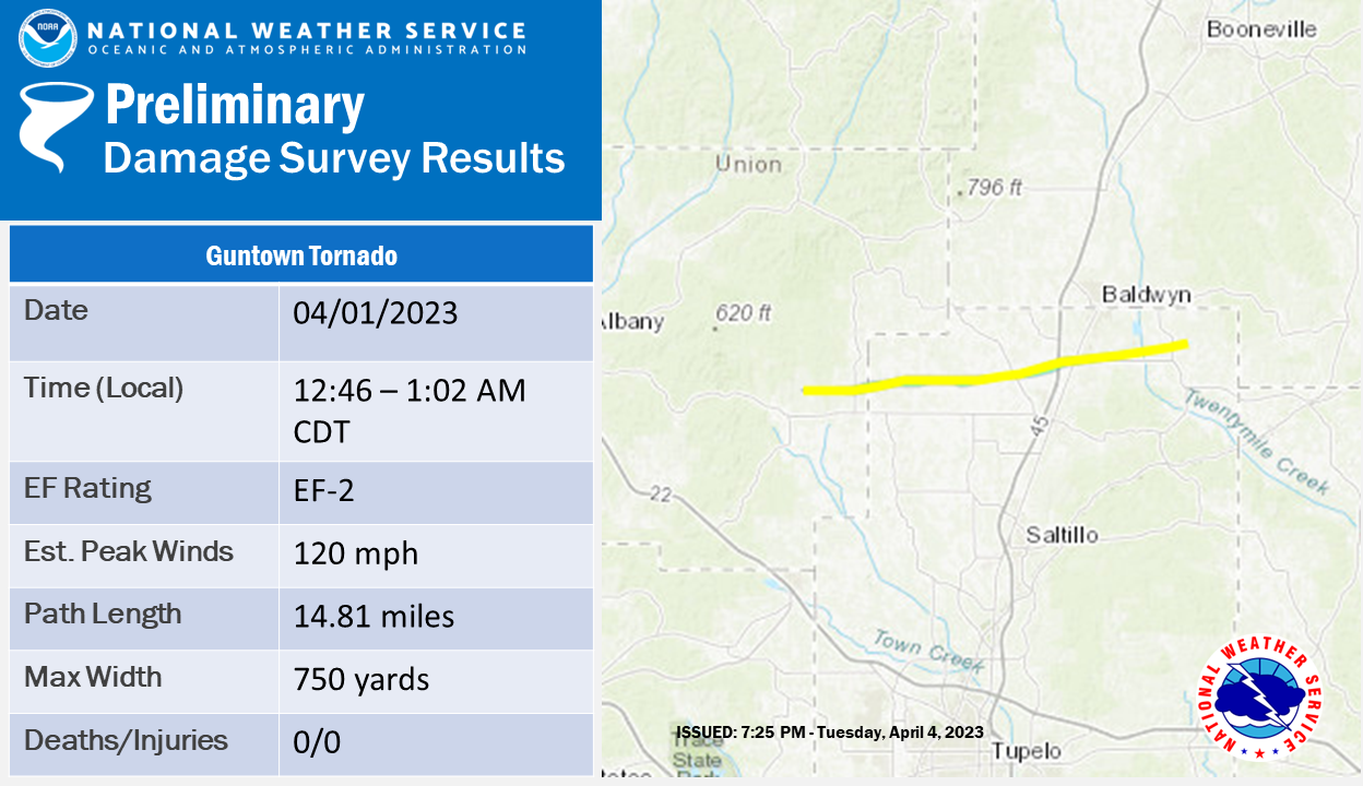
.Guntown Tornado...

Rating:                 EF2
Estimated Peak Wind:    120 mph
Path Length /statute/:  14.81 miles
Path Width /maximum/:   750 yards
Fatalities:             0
Injuries:               0

Start Date:             04/01/2023
Start Time:             12:46 AM CDT
Start Location:         5 NNE Blue Springs / Union County / MS
Start Lat/Lon:          34.463 / -88.8316

End Date:               04/01/2023
End Time:               01:02 AM CDT
End Location:           3 N Pratts Friendship / Lee County / MS
End Lat/Lon:            34.4884 / -88.5753

Survey Summary:
NWS meteorologists confirmed that an EF2 tornado moved through
parts of extreme eastern Union County and northern Lee County.
Damage first began along County Road 183 in Union County, with a
couple trees down. After crossing Highway 9, the tornado moved
into Lee County along County Road 2700, where more significant
tree damage was observed, earning an EF1 rating. A poorly
anchored home sustained roof removal and collapse of several
walls, consistent with a high-end EF1 rating. A church had
significant roof damage along County Road 231, and other
structures were damaged along County Roads 341 and 2726. In
particular, a mobile home/camper trailer was flipped and
destroyed in this area. The intensity of the damage picked up
along County Road 417, where a vacant double-wide mobile home was
swept away and a couple other homes sustained minor damage. Tree
damage here was significant as well. The tornado attained
EF2 intensity along County Road 503, where a two-story brick home
sustained major roof loss, which began with the uplift of the
front porch awning. An adjacent 32x32 two-story garage was swept
completely away and destroyed, although it appeared to be poorly
anchored. Along County Road 601, another home had total roof loss
and several walls collapsed, and extensive tree damage was
observed across the road.

Further eastward along County Road 601, another home was damaged,
and several cedar trees were snapped, consistent with an EF1
rating. Another area of heavier tree damage occurred along County
Road 2788 at Highway 45. In addition, the sign at the entrance to
an industrial park was damaged. Along Pratts Road, a church and a
shop building were damaged, and a few more homes were damaged
along the north side of Pratts Road. The tornado weakened
significantly after this point, with only lighter, more sporadic
tree damage. A couple more homes sustained minor roof damage along
Cemetery Road and Highway 370 before the tornado dissipated after
crossing County Road 2890.
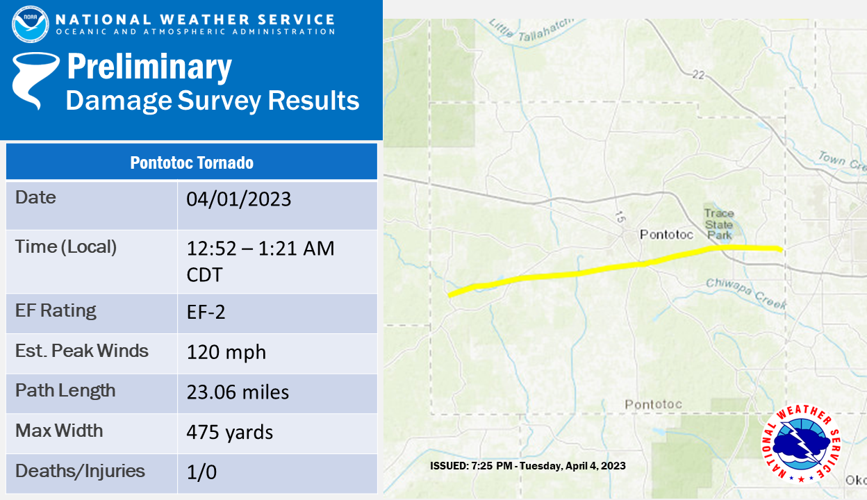
.Pontotoc Tornado...

Rating:                 EF2
Estimated Peak Wind:    120 mph
Path Length /statute/:  23.06 miles
Path Width /maximum/:   475 yards
Fatalities:             1
Injuries:               0

Start Date:             04/01/2023
Start Time:             12:52 AM CDT
Start Location:         3 W Randolph / Pontotoc County / MS
Start Lat/Lon:          34.189 / -89.223

End Date:               04/01/2023
End Time:               01:21 AM CDT
End Location:           2 E Furrs / Pontotoc County / MS
End Lat/Lon:            34.2337 / -88.8273

Survey Summary:
A storm survey of Pontotoc County confirmed an EF2 tornado moved
across the area around 1:00 am on April 1. The tornado began in
far western Pontotoc County, around Antioch Road, with a few
trees downed and tree limbs snapped. Along Highway 9 and Houpt
Road, tree damage became more significant and a few homes and
outbuildings sustained damage. A brick home on Highway
9 sustained heavy damage to the front side, mostly caused by a
large uprooted tree. Damage in this area was rated EF1. Weaker
damage continued south of the Springville community before
another area of EF1 damage was noted along Highway 341 at Foster
Lane. Here a brick home sustained significant roof loss, caused
partially by uplift of an open air carport. A few other homes had
roof damage as the tornado continued to the south side of
Pontotoc. A swath of more intense damage ran from Highway
15 across Highway 41 and East 10th Street, with numerous homes
sustaining considerable damage.

The tornado reached EF2 intensity in this area, based on a
double- wide mobile home being swept away, two brick homes having
significant roof loss, and a large anchored garage being
destroyed. Bolted footings that remained in place were observed
with the garage. Damage to other homes in the area was rated EF1,
and many trees were uprooted, with a good number of snaps as well.
Significant tree damage, along with minor structural damage,
continued across Horseshoe Bend, Hall Road, and New Hope Road,
maintaining EF1 intensity. After briefly weakening near Highway
278, the tornado encountered the College Hill Lane neighborhood
along Old Highway 6. Here, more significant damage was observed to
structures and trees, mostly pines. A site-built home lost part
of its roof, and a neighboring double-wide was swept away and
scattered south and east, resulting in a fatality.

Additionally, other homes sustained minor damage, and a small
barber shop building was rolled and destroyed. Damage continued in
the EF0 range from Faulkner Road to near the Lee County line,
with several more homes being damaged and numerous trees being
uprooted. The more severe home damage in this area appeared to be
a combination of tree failure or uplift of garages/carports, thus
the rating was kept at high- end EF0. At Country Oaks Circle, a
church sign and cemetery sign were blown down, and several
headstones in the cemetery sustained damage. The damage path
appeared to end in a grove of trees just south of Old Highway 6,
and no damage was observed on County Road 41 at the Pontotoc/Lee
county line. Roughly 75-100 structures were impacted along the
path.
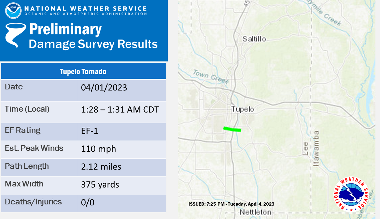
.Tupelo Tornado...

Rating:                 EF1
Estimated Peak Wind:    110 mph
Path Length /statute/:  2.12 miles
Path Width /maximum/:   375 yards
Fatalities:             0
Injuries:               0

Start Date:             04/01/2023
Start Time:             01:28 AM CDT
Start Location:         2 SSE Tupelo / Lee County / MS
Start Lat/Lon:          34.2327 / -88.7226

End Date:               04/01/2023
End Time:               01:31 AM CDT
End Location:           2 NW Plantersville / Lee County / MS
End Lat/Lon:            34.2276 / -88.6862

Survey Summary:
NWS meteorologists surveyed damage in southern Tupelo and
confirmed a relatively brief but strong EF1 tornado. Damage began
along Nixon Drive, with minor roof and tree damage. Several roofs
sustained damage along Chickasaw Trail, and several trees were
downed and a privacy fence was blown over near the North
Mississippi Medical Center Women`s Hospital. Several vehicles in
this area were damaged as well. The damage intensified
dramatically at the Legget and Platt warehouse, with likely
failure of west-facing garage doors leading to roof uplift and
collapse of most exterior walls. Damage here was rated high-end
EF1, with winds estimated at 110 mph. Several semi trailers were
shifted in the back parking lot, with one being flipped. After
crossing South Green Street, the Cooper Tire facility sustained
considerable roof loss to several buildings, with insulation and
roofing material scattered downwind. This damage was also rated
EF1, with estimated winds of 100 mph. After crossing Highway 45,
the damage path became weaker and slightly wider, with numerous
small trees and tree limbs being damaged amid an extensive debris
field from Cooper Tire. A small outbuilding was knocked down near
the end of South Veterans Blvd as the damage path ended. It
should be noted that excessive debris fallout continued for
several miles eastward, although no visible damage was observed
past South Veterans Blvd.
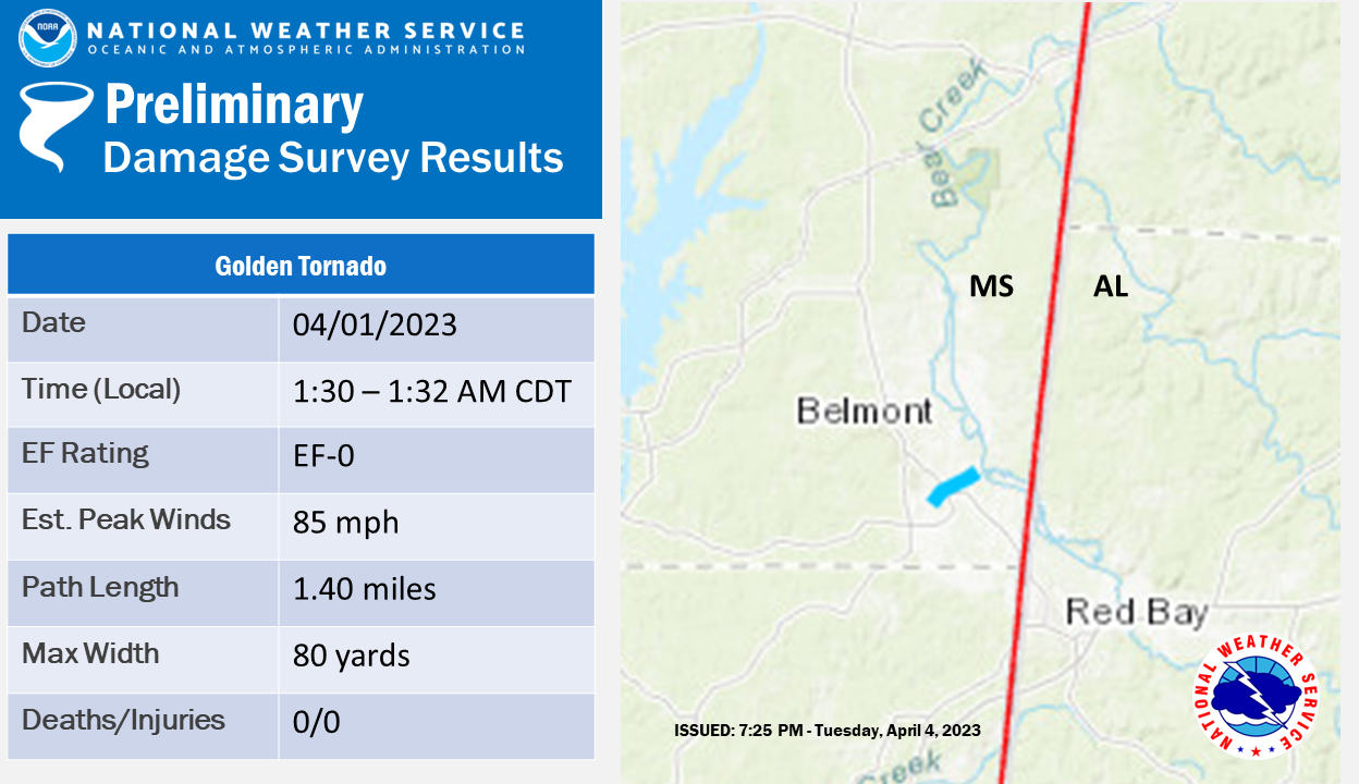
.Golden Tornado...

Rating:                 EF0
Estimated Peak Wind:    85 mph
Path Length /statute/:  1.40 miles
Path Width /maximum/:   80 yards
Fatalities:             0
Injuries:               0

Start Date:             04/01/2023
Start Time:             01:30 AM CDT
Start Location:         Golden / Tishomingo County / MS
Start Lat/Lon:          34.4851 / -88.1953

End Date:               04/01/2023
End Time:               01:32 AM CDT
End Location:           1 NNE Golden / Tishomingo County / MS
End Lat/Lon:            34.4967 / -88.1754

Survey Summary:
A brief tornado passed through Golden, with damage first
beginning along Patterson Street in the form of small tree limbs
and a power line downed. The most significant damage was along
Front Street, where a towing service building was knocked down, a
shed was flipped, and the framing of a house under construction
was collapsed. Also, along Line Road, a shed was destroyed and
power lines were downed. Numerous trees were uprooted from Line
Road to Moore Road as well. Additional trees were uprooted just
north of Bear Creek Road until the tornado dissipated on the
banks of Bear Creek.

&&

EF SCALE: THE ENHANCED FUJITA SCALE CLASSIFIES TORNADOES INTO THE
FOLLOWING CATEGORIES:

EF0...WEAK......65 TO 85 MPH
EF1...WEAK......86 TO 110 MPH
EF2...STRONG....111 TO 135 MPH
EF3...STRONG....136 TO 165 MPH
EF4...VIOLENT...166 TO 200 MPH
EF5...VIOLENT...>200 MPH

NOTE:
THE INFORMATION IN THIS STATEMENT IS PRELIMINARY AND SUBJECT TO
CHANGE PENDING FINAL REVIEW OF THE EVENTS AND PUBLICATION IN
NWS STORM DATA.

WE WOULD LIKE TO EXTEND OUR GRATITUDE TO NWS BIRMINGHAM, NWS
SHREVEPORT, NWS JACKSON, AND THE PERILS RESEARCH GROUP FOR
ASSISTANCE WITH GROUND SURVEYS.


$$

MJ/TAB/CAD/SMW/CJC/SJM/KRM/DKJ
NWUS54 KMEG 071613
LSRMEG

PRELIMINARY LOCAL STORM REPORT...SUMMARY
NATIONAL WEATHER SERVICE MEMPHIS TN
1113 AM CDT FRI APR 7 2023

..TIME...   ...EVENT...      ...CITY LOCATION...     ...LAT.LON...
..DATE...   ....MAG....      ..COUNTY LOCATION..ST.. ...SOURCE....
            ..REMARKS..

0600 PM     TSTM WND DMG     BRIGHTON                35.48N 89.74W
03/31/2023                   TIPTON             TN   AMATEUR RADIO

            LARGE TREES DOWN NEAR AKINS STORE ROAD AND
            HIGHWAY 51.

0605 PM     TORNADO          COVINGTON               35.57N 89.65W
03/31/2023                   TIPTON             TN   NWS STORM SURVEY

            *** 1 FATAL, 28 INJ ***
            EF-3.

0612 PM     TORNADO          COVINGTON               35.57N 89.65W
03/31/2023                   TIPTON             TN   AMATEUR RADIO

            POWER LINES AND TREES DOWN ON HIGHWAY 51
            SOUTH OF COVINGTON BLOCKING THE ROAD.

0615 PM     TORNADO          3 S COVINGTON           35.52N 89.65W
03/31/2023                   TIPTON             TN   AMATEUR RADIO

            ROOF DAMAGE AND WINDOWS BLOWN OUT AT
            CHEVROLET DEALARSHIP ON HIGHWAY 51 SOUTH OF
            DOWNTOWN COVINGTON.

0615 PM     TORNADO          COVINGTON               35.57N 89.65W
03/31/2023                   TIPTON             TN   LAW ENFORCEMENT

            THE COVINGTON HOSPITAL HAS BEEN DAMAGED WITH
            PATIENTS BEING REROUTED TO LAUDERDALE
            COUNTY.

0619 PM     TSTM WND GST     4 ENE COVINGTON         35.59N 89.59W
03/31/2023  M63 MPH          TIPTON             TN   MESONET

            MESONET STATION TT531 COVINGTON.

0955 PM     TSTM WND DMG     1 W GERMANTOWN          35.09N 89.81W
03/31/2023                   SHELBY             TN   PUBLIC

            SOFTWOOD TREES UPROOTED NEAR POPLAR PIKE AND
            GERMANTOWN ROAD.

0955 PM     TSTM WND DMG     2 NNW SOUTHEAST MEMPHIS 35.09N 89.89W
03/31/2023                   SHELBY             TN   PUBLIC

            LARGE OAK TREE UPROOTED AND FELL ON HOUSE.

1000 PM     TSTM WND DMG     4 WSW SOUTHEAST MEMPHIS 35.05N 89.96W
03/31/2023                   SHELBY             TN   BROADCAST MEDIA

            *** 3 FATAL ***
            SEVERAL TREES WERE BLOWN DOWN ON TOP OF
            SEVERAL HOUSES ON SOUTH EDGEWARE ROAD IN
            MEMPHIS. ONE ADULT AND TWO CHILDREN WERE
            FOUND DEAD IN ONE OF THESE HOUSES. TIME IS
            ESTIMATED BASED ON RADAR.

1000 PM     TSTM WND DMG     2 N SOUTHEAST MEMPHIS   35.10N 89.89W
03/31/2023                   SHELBY             TN   PUBLIC

            LARGE TREE UPROOTED AND CRUSHED PORTION OF
            HOME IN SEA ISLE NEIGHBORHOOD.

0930 PM     TSTM WND DMG     2 S BETHEL SPRINGS      35.21N 88.61W
03/31/2023                   MCNAIRY            TN   AMATEUR RADIO

            EXTENSIVE DAMAGE TO A CHURCH AND SEVERAL
            HOMES ON HIGHWAY 45 BETWEEN BETHEL SPRINGS
            AND SELMER.

0940 PM     TSTM WND DMG     1 W BETHEL SPRINGS      35.24N 88.63W
03/31/2023                   MCNAIRY            TN   AMATEUR RADIO

            REPORTS OF DAMAGE ON BUENA VISTA ROAD.

0940 PM     TSTM WND DMG     4 NW BETHEL SPRINGS     35.24N 88.61W
03/31/2023                   MCNAIRY            TN   FIRE DEPT/RESCUE

            A WALL COLLAPSED ON A HOUSE ON FLOWERS ROAD
            NEAR BETHEL SPRINGS.

0956 PM     TSTM WND DMG     SELMER                  35.17N 88.59W
03/31/2023                   MCNAIRY            TN   EMERGENCY MNGR

            TREES DOWN NEAR THE INTERSECTION OF DOWTY
            ROAD AND PEACH STREET ON THE NORTH SIDE OF
            SELMER.

1122 PM     TORNADO          4 SW BETHEL SPRINGS     35.19N 88.66W
03/31/2023                   MCNAIRY            TN   TRAINED SPOTTER

            CORRECTS PREVIOUS TORNADO REPORT FROM 4 SW
            BETHEL SPRINGS. POWER LINES KNOCKED DOWN AND
            GUARDRAILS THROWN IN THE ROAD. NUMEROUS
            TREES ARE DOWN CLOSE TO SKY BLUE LANE.

1135 PM     TORNADO          2 N ADAMSVILLE          35.26N 88.39W
03/31/2023                   MCNAIRY            TN   NWS STORM SURVEY

            *** 9 FATAL ***
            ADAMSVILLE, TN TORNADO EF-3.

1150 PM     TSTM WND DMG     2 WNW MORRIS CHAPEL     35.33N 88.39W
03/31/2023                   MCNAIRY            TN   NWS STORM SURVEY

            SEVERAL TREES UPROOTED ALONG HIGHWAY 22.
            THIS IS NORTH OF THE EARLIER EF2 TORNADO
            TRACK.

1155 PM     TSTM WND DMG     5 ESE HORNSBY           35.21N 88.75W
03/31/2023                   MCNAIRY            TN   NWS STORM SURVEY

            SEVERAL TREES UPROOTED ALONG HIGHWAY 64
            BETWEEN STAR LANE AND PRENTISS JOHNSON LANE.

1019 PM     TORNADO          3 ENE PARIS             36.31N 88.26W
03/31/2023                   HENRY              TN   EMERGENCY MNGR

            TREES AND POWER POLES DOWN AT GREEN HILLS
            ESTATE AND HWY 218. TIME ESTIMATED BY RADAR.

0628 PM     TORNADO          4W BROWNSVILLE          35.59N 89.25W
03/31/2023                   HAYWOOD            TN   EMERGENCY MNGR

            CORRECTS PREVIOUS TORNADO REPORT FROM
            BROWNSVILLE. A ROOF WAS BLOWN OFF A TRAILER
            ON PEPPER LANE IN BROWNSVILLE. SOME DEBRIS
            IS ON THE ROAD AND IN THE TREES.

0630 PM     TORNADO          3 W BROWNSVILLE         35.59N 89.31W
03/31/2023                   HAYWOOD            TN   AMATEUR RADIO

            ONE CHURCH WAS DESTROYED AND SEVERAL HOMES
            WERE DAMAGED NEAR THE INTERSECTION OF FULTON
            ROAD AND EVINS ROAD WEST OF BROWNSVILLE.

1125 PM     TORNADO          2 WSW PICKWICK DAM      35.03N 88.28W
03/31/2023                   HARDIN             TN   PUBLIC


1135 PM     TORNADO          2 NE ADAMSVILLE         35.26N 88.36W
03/31/2023                   HARDIN             TN   FIRE DEPT/RESCUE

            ONE HOUSE NEAR ADAMSVILLE HAD ITS ROOF TORN
            OFF.

0855 PM     TORNADO          2 NNW SAULSBURY         35.08N 89.11W
03/31/2023                   HARDEMAN           TN   NWS STORM SURVEY

            AN EF2 TORNADO PRODUCED WIDESPREAD TREE AND
            STRUCTURE DAMAGE FROM NEAR WESTFORK ROAD TO
            JUST EAST OF HIGHWAY 125 AND HEBRON ROAD.
            THE DAMAGE PATH WAS 12.8 MILES WITH A
            ESTIMATED MAXIMUM WIND OF 115 MPH.

1055 PM     TSTM WND DMG     HICKORY VALLEY          35.15N 89.13W
03/31/2023                   HARDEMAN           TN   TRAINED SPOTTER

            2" DIAMETER TREE LIMBS KNOCKED DOWN. METAL
            ROOFING IN ROADWAY.

0845 PM     TSTM WND DMG     1 WSW LA GRANGE         35.05N 89.25W
03/31/2023                   FAYETTE            TN   NWS STORM SURVEY

            SEVERAL TREES UPROOTED IN THE AREA AROUND LA
            GRANGE.

1105 PM     TSTM WND DMG     3 W SOMERVILLE          35.23N 89.41W
03/31/2023                   FAYETTE            TN   NWS STORM SURVEY

            DAMAGE TO THE SIGNAGE AND FAçADE OF A
            CONVENIENCE STORE OFF OF HIGHWAY 64 AND
            TEAGUE ROAD.

0707 PM     FUNNEL CLOUD     13 N PARSONS            35.84N 88.09W
03/31/2023                   DECATUR            TN   PUBLIC


1145 PM     TSTM WND DMG     ENVILLE                 35.39N 88.43W
03/31/2023                   CHESTER            TN   NWS STORM SURVEY

            CORRECTS PREVIOUS TSTM WND DMG REPORT FROM
            ENVILLE. MINOR TREE AND OUTBUILDING DAMAGE
            IN THE ENVILLE AREA.

0847 PM     TSTM WND DMG     5 SW HUNTINGDON         35.97N 88.48W
03/31/2023                   CARROLL            TN   PUBLIC

            REPORT FROM MPING: 3-INCH TREE LIMBS BROKEN;
            POWER POLES BROKEN.

1010 PM     TORNADO          4 NE MCLEMORESVILLE     36.03N 88.54W
03/31/2023                   CARROLL            TN   NWS STORM SURVEY

            A BRIEF TORNADO FORMED ALONG HIGHWAY 436,
            PRODUCING MINOR DAMAGE TO HOMES AND TREES.

1046 PM     TSTM WND DMG     5 SW HUNTINGDON         35.97N 88.48W
03/31/2023                   CARROLL            TN   PUBLIC

            REPORT FROM MPING: 1-INCH TREE LIMBS BROKEN;
            SHINGLES BLOWN OFF.

1029 PM     TORNADO          4 ESE VALE              36.10N 88.19W
03/31/2023                   BENTON             TN   NWS STORM SURVEY

            A BRIEF EF0 TORNADO PRODUCED MINOR DAMAGE
            ALONG CEDAR GROVE CHURCH ROAD.

1118 PM     TSTM WND DMG     3 SSE CAMDEN            36.02N 88.09W
03/31/2023                   BENTON             TN   PUBLIC

            TREES UPROOTED OR SNAPPED; ROOF BLOWN OFF.

0530 PM     TSTM WND DMG     4 ENE NORTH TUNICA      34.72N 90.31W
03/31/2023                   TUNICA             MS   PUBLIC

            DAMAGE TO SEVERAL HOMES ON VERNER ROAD.

0741 PM     FUNNEL CLOUD     3 WNW HOLLYWOOD         34.77N 90.25W
03/31/2023                   TUNICA             MS   PUBLIC

            FUNNEL CLOUD SEEN PASSING OVER MS HWY 3.

0754 PM     TORNADO          7 NE TUNICA             34.76N 90.29W
03/31/2023                   TUNICA             MS   EMERGENCY MNGR

            REPORT OF DAMAGE ON ARKLABUTLA DAM ROAD IN
            TUNICA COUNTY.

0755 PM     TSTM WND DMG     3.6 WNW EUDORA          34.85N 90.21W
03/31/2023                   TUNICA             MS   PUBLIC

            DOZENS OF TREES DOWNED AND AN OUTDOOR
            STORAGE STRUCTURE DESTROYED.

0810 PM     TSTM WND DMG     4 W TUNICA              34.69N 90.45W
03/31/2023                   TUNICA             MS   TRAINED SPOTTER

            SOME ROOF DAMAGE AND TREES DOWN NEAR THE
            INTERSECTION OF HIGHWAY 304 AND SCENIC LANE.

0815 PM     TORNADO          2 WNW BYHALIA           34.88N 89.72W
03/31/2023                   MARSHALL           MS   TRAINED SPOTTER

            POSSIBLE TORNADO.

0830 PM     TSTM WND DMG     2 SW SLAYDEN            34.93N 89.48W
03/31/2023                   MARSHALL           MS   PUBLIC

            REPORT FROM MPING: TREES UPROOTED OR
            SNAPPED; ROOF BLOWN OFF.

0735 PM     TORNADO          1 S EUDORA              34.82N 90.15W
03/31/2023                   DESOTO             MS   NWS STORM SURVEY

            NESBIT EF-1.

0752 PM     TSTM WND DMG     2 W HERNANDO            34.83N 90.02W
03/31/2023                   DESOTO             MS   EMERGENCY MNGR

            SEVERAL TREES WERE KNOCKED DOWN WITH ONE
            TREE ON A CAR ON HORN LAKE ROAD NORTH OF
            DEAN ROAD.

0659 PM     TORNADO          2 E MARVELL             34.56N 90.88W
03/31/2023                   PHILLIPS           AR   TRAINED SPOTTER

            SPOTTER REPORT OF A TORNADO.

0534 PM     TSTM WND DMG     1 ESE OSCEOLA           35.70N 89.98W
03/31/2023                   MISSISSIPPI        AR   EMERGENCY MNGR

            POWER POLES BROKEN AT INTERSECTION OF HWY 61
            AND HWY 325. TIME ESTIMATED FROM RADAR.

0438 PM     TORNADO          7 WSW WYNNE             35.20N 90.90W
03/31/2023                   CROSS              AR   TRAINED SPOTTER

            UNCONFIRMED REPORT OF TORNADO AR 284-193 W
            OF WYNNE BY TRAINED SPOTTER.

0443 PM     TORNADO          1 WSW WYNNE             35.23N 90.80W
03/31/2023                   CROSS              AR   TRAINED SPOTTER

            UNCONFIRMED TORNADO ON GROUND 2 MI WEST OF
            WYNNE.

0445 PM     TORNADO          WYNNE                   35.23N 90.79W
03/31/2023                   CROSS              AR   NWS STORM SURVEY

            EF-3.

0445 PM     TORNADO          WYNNE                   35.23N 90.79W
03/31/2023                   CROSS              AR   LAW ENFORCEMENT

            CITY OF WYNNE HAS HAD DAMAGE ALL OVER TOWN
            INCLUDING WYNNE HIGH SCHOOL. DOZENS OF
            PEOPLE ARE BELIEVED TO BE TRAPPED.

0500 PM     TORNADO          3 W PARKIN              35.27N 90.60W
03/31/2023                   CROSS              AR   PUBLIC

            REPORT FROM MPING: HOMES/BUILDINGS
            COMPLETELY DESTROYED.

0501 PM     TSTM WND GST     6 W PARKIN              35.26N 90.66W
03/31/2023  M64 MPH          CROSS              AR   MESONET

            MESONET STATION UP525 5.9 W PARKIN (UPR).

0510 PM     TORNADO          WYNNE                   35.23N 90.79W
03/31/2023                   CROSS              AR   AMATEUR RADIO

            REPORTS OF DAMAGE JUST EAST OF COUNTRY ROAD
            NEAR WYNNE.

0505 PM     TORNADO          2 N EARLE               35.30N 90.47W
03/31/2023                   CRITTENDEN         AR   PUBLIC

            REPORT FROM MPING: HOMES/BUILDINGS
            COMPLETELY DESTROYED.

0505 PM     TORNADO          2 N EARLE               35.30N 90.47W
03/31/2023                   CRITTENDEN         AR   PUBLIC

            REPORT FROM MPING: TREES UPROOTED OR
            SNAPPED; ROOF BLOWN OFF.

0525 PM     TSTM WND DMG     2 SSW TURRELL           35.34N 90.27W
03/31/2023                   CRITTENDEN         AR   PUBLIC

            TRUCK OVERTURNED AS TORNADO CROSS I-55.


&&

$$

