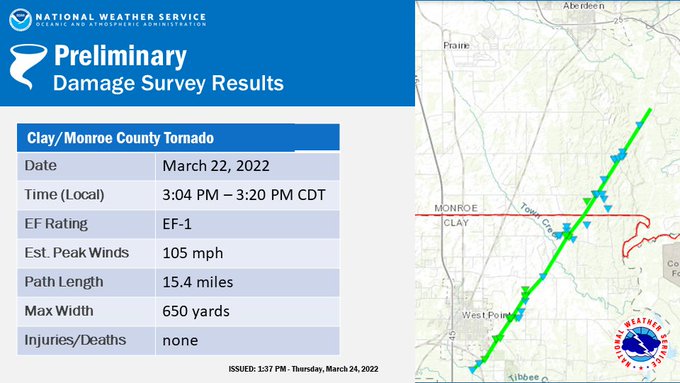
NOUS44 KMEG 242018
PNSMEG
ARZ009-018-026>028-035-036-048-049-058-MOZ113-115-MSZ001>017-
020>024-TNZ001>004-019>022-048>055-088>092-250830-

Public Information Statement
National Weather Service Memphis TN
318 PM CDT Thu Mar 24 2022

...NWS Damage Survey For Clay/Monroe MS Tornado - Update 1...

.OVERVIEW...This is an update to include the start of the tornado
in Clay County, Mississippi surveyed by the National Weather Service
in Jackson, Mississippi.

.CLAY/MONROE TORNADO...

Rating:                 EF1
Estimated Peak Wind:    105 mph
Path Length /statute/:  15.4 miles
Path Width /maximum/:   650 yards
Fatalities:             0
Injuries:               0

Start Date:             3/22/2022
Start Time:             3:04 PM CDT
Start Location:         2 S West Point / Clay County / MS
Start Lat/Lon:          33.57 / -88.6414

End Date:               3/22/2022
End Time:               3:20 PM CDT
End Location:           3 WNW New Hamilton / Monroe County / MS
End Lat/Lon:            33.76 / -88.49


SURVEY SUMMARY:

The stats and summary include information for the entire tornado
path, with the Clay County portion surveyed by National Weather
Service Jackson, Mississippi.

This tornado began south of West Point along Section Road in
Clay County Mississippi. It uprooted a few trees as it tracked
across Hackberry Road and the Kansas City Southern railroad
tracks. The tornado intensified to EF1 strength and it continued
to the northeast across Waverly Road and East Church Hill Road,
where it snapped and uprooted hardwood and softwood trees. The
tornado continued northeast to Highway 50 east, where it snapped
several power poles and a few trees. The tornado continued
northeast and crossed Barton Ferry Road, where it snapped several
trees and caused some minor damage to a few homes. The tornado
caused minor roof damage to some buildings at Prairie Livestock
before snapping and uprooting additional trees along Old Vinton
Road. The tornado then continued to the northeast and crossed into
Monroe County.

In Monroe County, the most significant damage occurred south of
Strong Road on Lakeview Drive where several trees were snapped
along with a broken power pole. Additional trees were snapped
along with some large trees down on Strong Road west of the
intersection of Strong Road and Darracott Road. The tornado then
moved northeast and weakened producing additional tree damage on
Darracott Road and also on Richardson Lake Road. The tornado
dissipated near Kerr McGee Road.

EF Scale: The Enhanced Fujita Scale classifies tornadoes into the
following categories:

EF0...Weak......65 to 85 mph
EF1...Weak......86 to 110 mph
EF2...Strong. ..111 to 135 mph
EF3...Strong....136 to 165 mph
EF4...Violent...166 to 200 mph
EF5...Violent...> 200 mph

NOTE: Information in this statement is preliminary and subject to
change pending final review of the event and publication in NWS
Storm Data.

Special thanks to NWS Jackson, MS for damage survey coordination with the
Clay/Monroe County Tornado.

$$

SWB/CJC