...JUNE 2013 MONTHLY CLIMATE SUMMARY...
June 2013 brought near average temperatures to the Mid-South. In fact, of the four sites detailed in this summary, Jonesboro was the only one with a monthly average temperature departure greater than one degree above normal. Jackson’s monthly average temperature was exactly the normal for June, while Memphis and Tupelo had a 0.2 degree and a 0.5 degree departure from normal, respectively. Despite all of the sites being at or slightly above normal for temperatures this month, Tupelo is the only site with an above normal temperature for 2013 so far, but only by 0.2 degrees. Jackson and Memphis are 1.1 degrees and 0.9 degrees below the yearly normal, respectively.
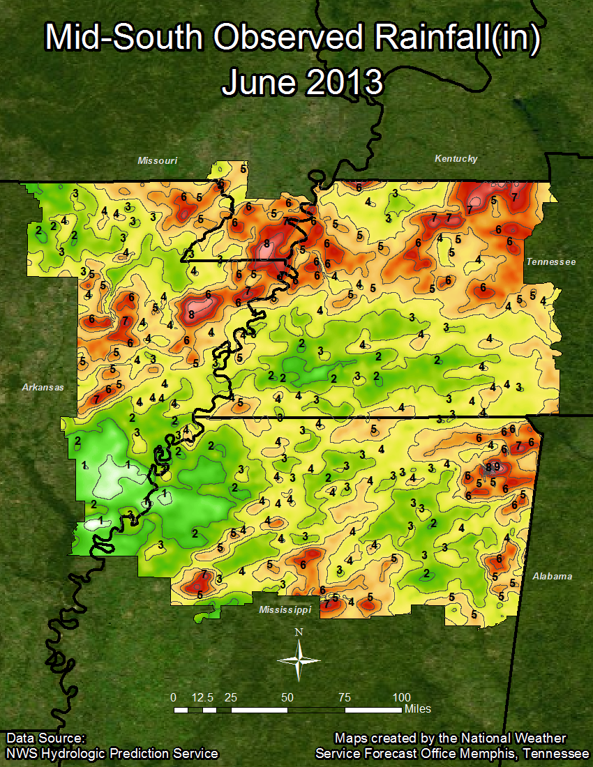
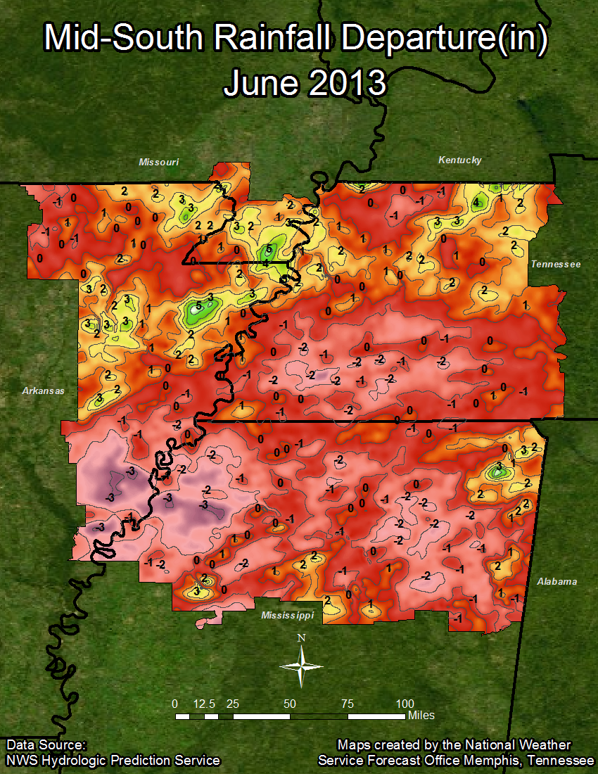
As for precipitation, while April and May were abnormally wet for the region, Jackson and Tupelo were both greater than two inches below normal in June. On the other hand, Memphis was almost two inches above normal, with Jonesboro above normal by only 0.25 inches. Despite a comparatively drier month, all sites are still above normal for the year, with Memphis currently sitting 12.14 inches above normal for 2013. Tupelo has been the driest site so far this year, currently at only 1.35 inches above normal.
Temperature Data:
Memphis Jackson Jonesboro Tupelo
Average Temperature (MONTH) : 79.8 76.2 79.7 78.6
Normal Avg. Temp (MONTH) : 79.6 76.2 77.8 78.1
Departure from Normal (MONTH): 0.2 0.0 1.9 0.5
Average Temperature (YEAR) : 58.2 55.0 55.8 58.0
Normal Avg. Temp (YEAR) : 59.2 56.1 56.0 57.8
Departure from Normal (YEAR) : -0.9 -1.1 -0.3 0.2
Precipitation Data:
Memphis Jackson Jonesboro Tupelo
Total Precipitation (MONTH) : 5.47 2.78 4.00 2.04
Normal Precipitation (MONTH) : 3.63 4.84 3.75 4.52
Departure from Normal (MONTH): 1.84 -2.06 0.25 -2.48
Total Precipitation (YEAR) : 40.05 37.76 30.34 30.47
Normal Precipitation (YEAR) : 27.91 28.38 25.03 29.12
Departure from Normal (YEAR) : 12.14 9.38 5.31 1.35
Monthly Significant Weather Synopsis:
The month of June came in and went out with severe weather. On the first day of June there were numerous reports of damage due to severe weather after a squall line moved across the area. Many of these reports were of flooding out of eastern Arkansas. This included one report of up to twelve inches of water on secondary roads in the Walnut Ridge, Arkansas vicinity. There were also several reports of strong damaging winds, particularly across northern Mississippi, where a tree fell across a house in Lafayette County. An approaching cold front combined with daytime heating produced another round of severe thunderstorms on the fifth of June. This time there were numerous reports of wind damage from eastern Arkansas, while up to golfball sized hail was reported in Mississippi.
Another frontal passage on the ninth of June produced a squall line that produced damaging storms. Most of the damage reports were of hail and strong winds, including twenty-eight power poles down, a car blown into a ditch, and three other cars with blown out windows in Tunica, Mississippi. Most areas across the region experienced highs in the 90s for the first time on June 10th, eleven days before the first official day of summer, which occurred on June 21st. The final round of severe weather came on June 27 and 28 as a cold front approached and moved across the area. These storms produced hail up to an inch in diameter, as well as wind gust speeds estimated at near 80 MPH.
MAYE

