January 22-23 Severe Weather Outbreak
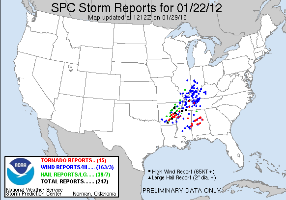
To view the preliminary storm reports click here.
To view the preliminary storm reports on the SPC webpage click here.
EVENT SUMMARY:
On January 22nd, an unusually strong weather system was making its way towards the Midsouth. A low pressure system developed over the southern plains and moved to the northeast. The strong low pressure system had moved to the Kansas and Missouri border by the time the event started. A very strong low-level jet, along with a very strong jet stream, moved across the Midsouth during the evening hours. An upper level short wave moved across Arkansas during the early evening hours. This short wave was the focus of thunderstorm development. The storms initially began as supercells, producing numerous large hail and tornadoes across the portions of Arkansas served by WFO Little Rock. A couple of those tornadoes were strong. By the time the storms started crossing into the WFO Memphis area, the storms had begun congealing into a squall line. A few supercells did develop ahead of the squall line, but thankfully no tornadoes were spawned by these storms. The potential for strong tornadoes was high across the Midsouth; however, there was not enough instability to keep the updrafts sustained and the storms more discrete. Cloud cover through the peak heating time (mid to late afternoon) prevented higher temperatures across the region; thus, reducing the amount of surface based CAPE (Convective Available Potential Energy). Also, the storms moved through during the nighttime hours, which likely added to the reduced CAPE values. As a result, only 3 weak tornadoes occurred in the WFO Memphis area of responsibility. These tornadoes formed in small scale areas of rotation embedded in the squall line. However, there were plenty of wind damage reports due to the squall line. The squall line was able to produce very strong winds in the bowing segments because the thunderstorms were able to force the strong low level jet down to the ground. Additional storms developed later that night ahead of the squall line across WFO Birmingham's area that produced some strong tornadoes.
Storm Survey Results:
Survey teams dispatched Monday January 23rd found:
- EF-0 tornado in Quitman County, Mississippi.
Beginning point: 34 deg 15' 42" N / 90 deg 18' 13" W
Ending point: 34 deg 15' 44" N / 90 deg 17' 56" W
Location: 2 miles WNW of Marks, MS
Estimated peak wind: 65 mph
Max width: 75 yards
Path length: 1/4 mile
Injuries: None
Fatalities: None
Summary: About 7 homes damaged....ranging from singles, to minor roofing material, to garage door blown out and numerous windows broken.
- Straight-line wind damage in Memphis, Tennessee.
Estimated wind speeds of 105 mph lifted a large roof off of a building and dropped it about 200 feet away. Damage was 3 miles east of Memphis International Airport which occurred about 10:20 pm.
- Straight-line wind damage near Hickory Valley and Middleburg, Tennessee.
Estimated wind speeds of 100 mph damaged numerous trees. The damage was focused in two locations...one just north of Hickory Valley and the other near Middleburg, Tennessee around 11:15 pm. Only minor damage was reported from nearby buildings, except for those that had trees land on them.
Survey teams dispatched Tuesday January 24th found:
- Straight-line wind damage in Clarksdale, Mississippi.
Estimated wind speeds of 60 to 70 mph flipped an 18 wheeler and pushed a mobile home back 3 feet. Large dents were also found on the front of mobile home where the wind hit. All damage was confined to the portion of the home facing to the southwest.
- Straight-line wind damage near Bobo, Mississippi, southwest of Clarksdale.
Estimated wind speeds of 75 mph caused significant damage to empty grain bins along New Africa Road. The walkway on top of the grain bins was blown down. One grain bin was moved back a foot or two off of its foundation. Each grain bin had dents near the top on the southwest side where the strongest winds hit. Powerlines were also blown down in the same area.
- Straight-line wind damage near Turkey Scratch, Arkansas, north of Marvell.
Estimated wind speeds of 115 mph caused significant damage to some metal buildings, a house, and some very large trees. The hardwood trees were approximately 3 feet wide. One metal building had a portion of the roof peeled up as well as 2 garage doors blown in. The grain bins behind the metal building sustained dents near the top due to the winds. The house was damaged by one of the large trees falling on top of it. A couple mobile homes were damaged as well with their roofs blown off. Additional smaller trees were snapped in the vicinity.
- Straight-line wind damage near West Helena, Arkansas.
Estimated wind speeds of 100 mph destroyed multiple mobile homes on the west side of West Helena. One mobile home was flipped on the southwest side of a neighborhood on the outskirts of town. The bottom frame of the home struck a tree behind the home 15 feet in the air. The mobile home landed on its roof and was completely destroyed. Cars were damaged by flying debris and trees were also blown down. Another neighboorhood southwest of town was damaged as well. In this neighboorhood, 2 mobile homes were flipped. One was blown into another mobile home and a wood house. Powerlines and irrigation systems were blown down in the fields between the two neighboorhoods. In West Helena, only minor damage was noted to the Junior High School roof and the roof and siding of a few motels. A few storage sheds were blown over but had not been secured to the ground.
Survey teams dispatched Wednesday January 25th found:
- EF-1 tornado in Henderson County, Tennessee.
Beginning point: 35 deg 35' 6" N / 88 deg 23' 33" W
Ending point: 35 deg 38' 31" N / 88 deg 16' 9" W
Location: 5 miles S of Lexington, TN
Estimated peak wind: 105 mph
Max width: 150 yards
Path length: 8 miles
Injuries: None
Fatalities: None
Summary: Numerous trees were uprooted or snapped along the path. A portion of a roof was blown off a house. A shed in the backyard was also destroyed. The tornado touched down primarily on ridge tops before eventually lifting just northeast of Butterscotch Road.
- EF-1 tornado in Phillips County, Arkansas.
Beginning point: 34 deg 32' 39" N / 91 deg 0' 58" W (NWS Memphis, entered from NWS Little Rock)
Ending point: 34 deg 33' 43" N / 91 deg 0' 59" W
Location: 4 miles south of Ragtown to 1 mile south of Postelle
Estimated peak wind: 105 mph
Max width: 150 yards
Path length: 8 miles
Injuries: None
Fatalities: None
Summary: In WFO Little Rock's area, trees and power poles were blown down. An irrigation pivot was flipped over. A large storage shed was tossed over a farm building. In WFO Memphis' area, a few trees were knocked down and minor tree damage was noted. A couple of irrigation pivots were overturned. Some grain bins were also dented towards the top.


