...DECEMBER 2013 MONTHLY CLIMATE SUMMARY...
The final month of 2013 was near normal in both temperature and precipitation, despite experiencing an ice storm and severe weather event only two weekends apart. Jackson was the site with the temperature closest to its normal, with an average monthly temperature of 40.7 degrees, only a tenth of a degree below the normal of 40.8 degrees. Memphis was actually the next closest with an average temperature of 43.2 degrees, four tenths of a degree below the normal of 43.6 degrees. Tupelo’s average temperature of 43.6 for December was only a half of a degree below the normal of 44.1 degrees, while Jonesboro had the average temperature with the greatest departure from normal at 38.9 degrees, which was only six tenths of a degree below the normal of 39.5 degrees. All four of the sites were within a degree and a half below normal for the year. Jackson was the coolest site in 2013 with an annual average temperature of 58.5 degrees, and also had the greatest departure from its normal annual average temperature of 59.8 at 1.3 degrees below normal. Memphis was the warmest site with an average temperature for the year of 62.2 degrees. A more detailed looked at the climate for 2013 will be provided in the 2013 Climate Summary.
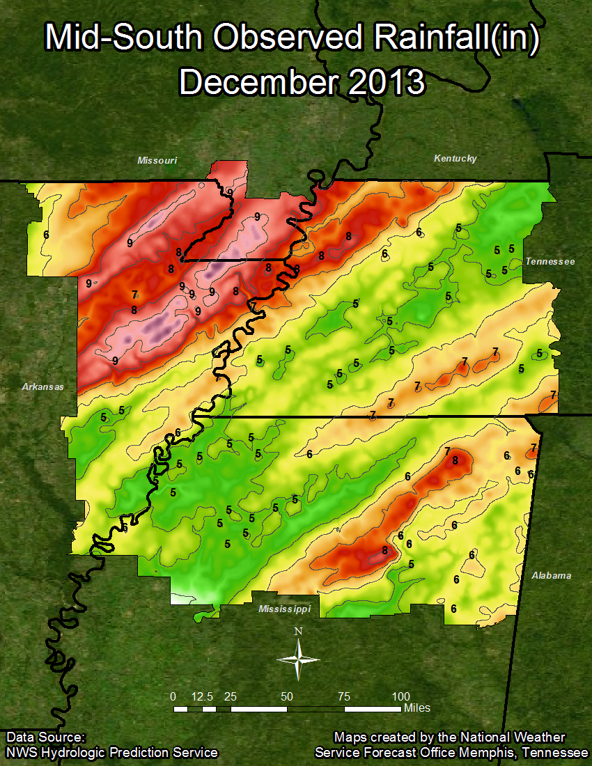
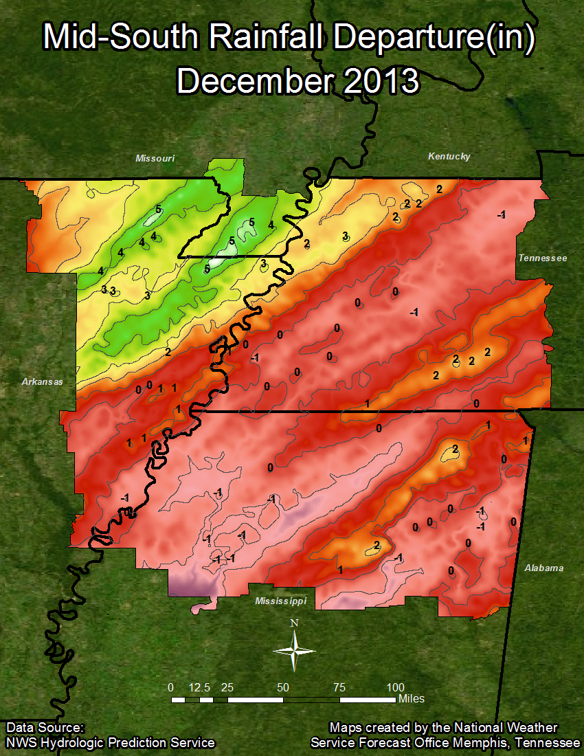
Jonesboro received the most precipitation this month with 6.44 inches, 1.67 inches above the normal for December of 4.77 inches. Jonesboro was the only site in the summary to report snow this month with 1.0 inch of total snowfall and a total snow depth for the month of 0.2 inches. Tupelo had the second highest precipitation total for the month at 6.18 inches, a departure of a tenth of an inch below the December normal of 6.28 inches. Memphis received 4.82 inches of precipitation this December, 0.92 inches below the normal of 5.74 inches, while Jackson was the driest site this month with 4.80 inches of precipitation, a 0.55 inch departure from the normal of 5.35 inches. For the year, Memphis was the wettest site with 59.43 inches of precipitation. Meanwhile, Jonesboro was the driest site at 52.42 inches of precipitation.
TEMPERATURE DATA:
Memphis Jackson Jonesboro Tupelo
Average Temperature (MONTH) : 42.8 40.3 38.4 43.4
Normal Avg. Temp (MONTH) : 43.6 40.8 39.5 44.1
Departure from Normal (MONTH): -0.8 -0.5 -1.1 -0.7
Average Temperature (YEAR) : 62.1 58.5 59.7 61.6
Normal Avg. Temp (YEAR) : 63.1 59.8 60.0 62.5
Departure from Normal (YEAR) : -1.0 -1.3 -0.3 -0.9
PRECIPITATION DATA:
Memphis Jackson Jonesboro Tupelo
Total Precipitation (MONTH) : 4.82 4.80 6.44 6.18
Normal Precipitation (MONTH) : 5.74 5.35 4.77 6.28
Departure from Normal (MONTH): -0.92 -0.55 1.67 -0.10
Total Precipitation (YEAR) : 59.43 58.32 52.42 52.76
Normal Precipitation (YEAR) : 53.68 53.27 48.10 55.01
Departure from Normal (YEAR) : 5.75 5.05 4.32 -2.25
Significant Weather:
There is plenty to speak of in terms of significant weather for December. First of all, the Mid-South was affected by a winter storm in early December, bringing a mixture of ice, sleet, and snow to various parts of the area. Up to a half inch of ice accumulation occurred on December 6th in parts of northwest Tennessee, with the majority of our Arkansas counties and the Missouri boot heel experiencing a quarter of an inch in ice accumulation, and parts of west Tennessee and northwest Mississippi receiving a tenth of an inch of ice accumulation. Sleet accumulation from this event was greatest in northeast Arkansas and the Missouri boot heel, with some areas receiving over 1.5 inches of sleet accumulation. Areas in west Tennessee saw anywhere from a trace to an inch of sleet accumulation during this event. Snow accumulations were only reported in northeast Arkansas and the Missouri boot heel, where some areas saw up to six inches of snow. A second slight ice event occurred the night of December 7th into the day on December 8th. This brought up to a quarter of an inch in new ice accumulation, primarily in west Tennessee and north Mississippi.
On December 21st a low pressure system and associated fronts brought a round of severe weather to the Mid-South. While there were numerous reports of trees and power lines down due to strong winds, the biggest story of this event was that it produced five tornadoes in our area. The first tornado touched down near Hughes, Arkansas and was rated an EF2, with an estimated maximum wind speed of 130 MPH, a path length of 15.6 miles, and a width of 300 yards. This tornado resulted in three injuries and one death. The second tornado touched down near Rena Lara, Mississippi at about 5:19 PM and was rated and EF2 with an estimated maximum wind speed of 120 MPH, a path length of 10.4 miles, and a width of 300 yards. This tornado caused at least one injury and one death. The next tornado occurred around 5:57 PM near Senatobia, Mississippi, and was rated an EF1 with an estimated maximum wind speed of 100 MPH, a path length of 6.2 miles, and a width of 200 yards. There were no injuries or fatalities reported with this tornado. At around 5:40 PM a tornado touched down in southern Tunica County. This one was rated an EF1 with an estimated maximum wind speed between 90 and 100 MPH, a path length of 2.7 miles, and a width of 200 yards. No injuries or deaths were reported with this tornado. The final tornado of this event occurred at around 6:13 PM near Independence, Mississippi. This tornado was rated an EF0 with an estimated maximum wind speed between 65 and 80 MPH, a path length of 0.75 miles, and a width of 100 yards. No injuries or fatalities were reported as a result of this tornado.
Climate Outlook:
The Climate Prediction Center has given an equal chance of receiving above normal, below normal, or normal temperatures and precipitation for the month of January. Considering a three month period (January, February, and March), the CPC has given a chance of above normal temperatures during this time frame, with an equal chance of receiving above normal, below normal, or normal precipitation totals.
MAYE

