December 10-11, 2021 Tornado Outbreak
Synopsis
An ominous signal for severe weather was apparent across the Mid-South leading up to the tornadoes of December 10-11, 2021. A strong upper-level trough was approaching from the west, providing strong lift within an unseasonably warm and unstable air mass. Temperatures warming to near 80 degrees during the afternoon hours aided instability with a strong wind field providing the vertical wind shear needed for organized thunderstorms.
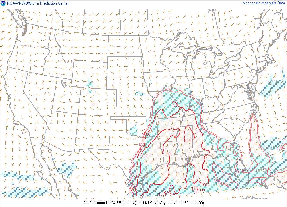
The instability wasn’t extreme, but it was more than adequate to sustain strong updrafts. Mean-layer CAPE (MLCAPE) was maximized at 1500-2000 J/kg (Figure 1) at 6 PM, which was around the time that the initial supercell began to affect the Mid-South.
Figure 1. MLCAPE at 00z via SPC Mesoanalysis Page.
Meanwhile, strong winds at the surface and aloft provided the wind shear necessary for organized severe weather. Effective layer bulk shear was around 70 kts across most of the Mid-South while the effective storm-relative helicity was in the range of 300-400 m2s-2. The combination of these key ingredients suggested the likelihood of severe weather during the evening and overnight period. This threat would be particularly enhanced if any supercells developed in the open warm sector ahead of the overnight complex with the cold front.
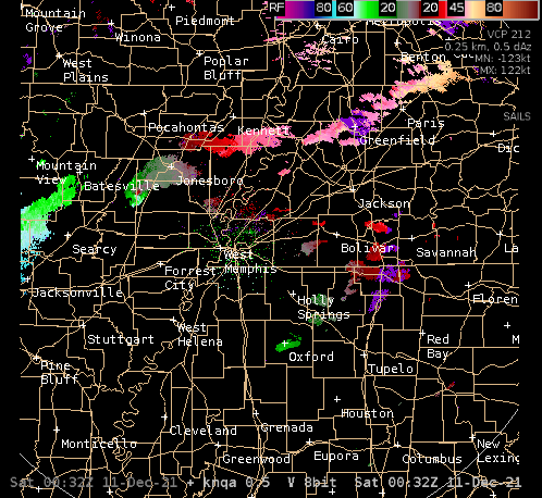
Radar Images (County Warning Area)
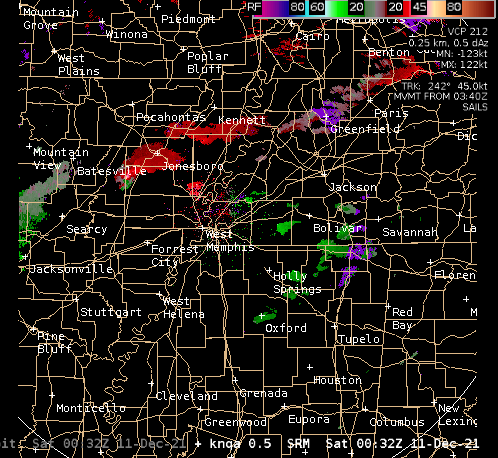
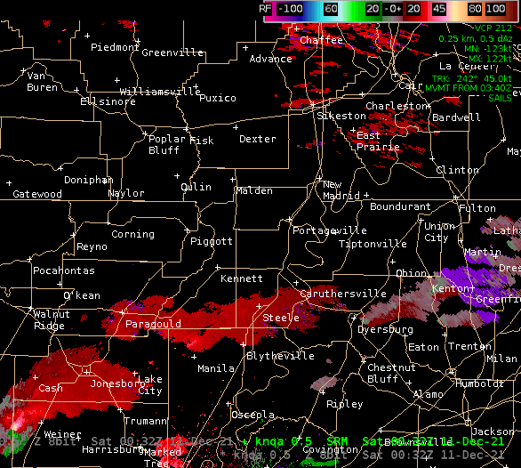
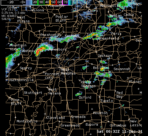 |
 |
KNQA WSR-88D Reflectivity Loop
KNQA WSR-88D Storm Relative Velocity Loop
KNQA WSR-88D Velocity Loop
Storm Surveys:
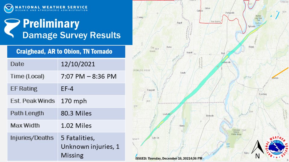
Craighead County, Arkansas to Obion County, Tennessee tornado
Newbern to Paris Landing, Tennessee tornado
Tornadoes in Madison, Henderson, and Decatur Counties in Tennessee
Truman Tornado in Poinsett County, Arkansas
Prentiss County, Mississippi Tornado
Craighead County, Arkansas to Obion County, Tennessee tornado
 |
 |
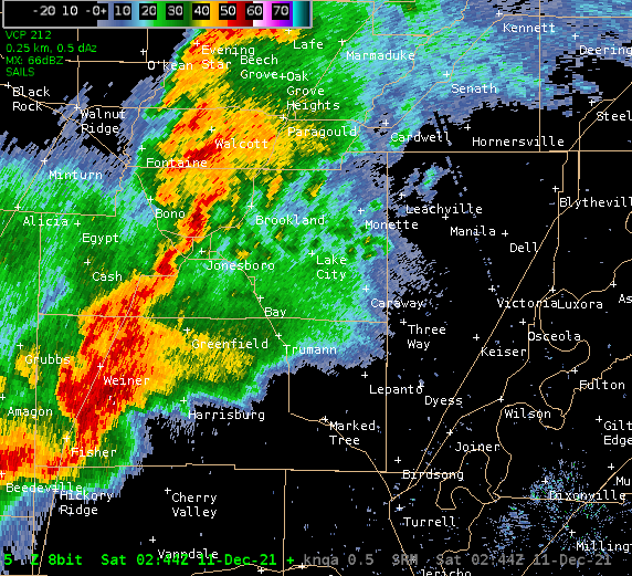
The first supercell developed in central Arkansas around mid-afternoon and moved into Poinsett County around 6 PM. This lone storm had a robust convective environment all to its own. The first tornado touched down near Weiner at 6:40 PM, primarily felling trees, though one home sustained damage due to a falling tree. As this storm moved northeast, a second tornado occurred south of Jonesboro, damaging a rice factory. Around this time, the mesocyclone cycled, and the storm produced a pair of concurrent tornadoes to the west of Bay.
Storm rotation intensified as the supercell passed to the east of Jonesboro with the tornado increasing in size and strength as it moved across the northern portion of Monette. Numerous structures sustained significant (EF-3) damage, including a nursing home where one resident was killed. This storm remained very intense, as it crossed the county line and affected the northern extent of Leachville. A second fatality occurred at the Dollar General with other structures sustained heavy damage.
Damage to the Dollar General Store in Leachville, AR.
Additional significant damage occurred from this cell as it moved through Dunklin and Pemiscot Counties. Numerous homes were damaged and utility poles snapped as the storm crossed south of Hornersville and north of Steele. Several houses were completely destroyed (EF-4) in the Braggadocio area where a third fatality was reported. Several other significant injuries occurred in this area as well.
EF-4 rated damage near Braggadocio, MO.
The tornado maintained intensity as it split Hayti and Caruthersville, making a few passes over the meandering Mississippi River. The tornado debarked trees in central Lake County and finally struck the Samburg area on Reelfoot Lake. There were 4 fatalities in this area with an unknown number of injuries. This tornado dissipated a few miles northeast of Samburg, leaving an 80 mile trail of destruction with a path width up to 1 mile wide at times. This long-track tornado was rated EF-4 with maximum winds of 170 mph. It was responsible for 7 deaths and numerous injuries.
Public Information Statement
National Weather Service Memphis TN
402 PM CST Thu Dec 16 2021

...NWS Damage Survey For 12/10/21 Tornado Event...

.OVERVIEW...
This statement summarizes the tornadoes produced by the long-track
supercell storm that moved from western Poinsett County AR, to
Obion County TN, and into Kentucky.

PLEASE NOTE...The information regarding tornado #4 below, from
Craighead County to Obion County, is based on data from ground
surveys. We are continuing to evaluate data from UAS, aircraft, and
satellites regarding the storm`s evolution as it moved through
Obion County. If the data from the supplemental sources reveals
additional critical information, this statement will be updated.

.1: Tornado in Western Poinsett County...

Rating:                  EF-0
Estimated Peak Wind:     65 mph
Path Length /Statute/:   2.9 miles
Path Width /Maximum/:    50 yards
Fatalities:              0
Injuries:                0

Start Date:              Dec 10 2021
Start Time:              06:40 PM CST
Start Location:          2.2 WSW Weiner / Poinsett County / AR
Start Lat/Lon:           35.6067 / -90.9342

End Date:                Dec 10 2021
End Time:                06:43 PM CST
End Location:            0.9 E Weiner / Poinsett County / AR
End Lat/Lon:             35.6222 / -90.8849

SURVEY SUMMARY: A brief tornado damaged trees southwest of Weiner.
A tree fell against a house in Weiner.


.2: Tornado in Southern Craighead County...

Rating:                  EF-1
Estimated Peak Wind:     100 mph
Path Length /Statute/:   6.2 miles
Path Width /Maximum/:    150 yards
Fatalities:              0
Injuries:                0

Start Date:              Dec 10 2021
Start Time:              06:57 PM CST
Start Location:          2.7 WSW Cary / Craighead County / AR
Start Lat/Lon:           35.7084 / -90.7330

End Date:                Dec 10 2021
End Time:                07:01 PM CST
End Location:            3.5 NE Cary / Craighead County / AR
End Lat/Lon:             35.7491 / -90.6356

SURVEY SUMMARY: A tornado developed near the Poinsett/Craighead County
line and damaged trees along County Road 452. The tornado damaged a
cotton gin along Highway 1, and destroyed a storage building near
County Road 406.  The tornado dissipated as it approached Highway 158.


.3: Tornado West of Bay...

Rating:                  EF-0
Estimated Peak Wind:     65 mph
Path Length /Statute/:   1.2 miles
Path Width /Maximum/:    50 yards
Fatalities:              0
Injuries:                0

Start Date:              Dec 10 2021
Start Time:              07:03 PM CST
Start Location:          2.0 WSW Bay / Craighead County / AR
Start Lat/Lon:           35.7326 / -90.5971

End Date:                Dec 10 2021
End Time:                07:04 PM CST
End Location:            1.1 WNW Bay / Craighead County / AR
End Lat/Lon:             35.7477 / -90.5831

SURVEY SUMMARY: A brief tornado caused minor damage to trees and
storage buildings just west of Interstate 555, west of Bay.


.4: Tornado From Craighead County to Obion County...

Rating:                  EF-4
Estimated Peak Wind:     170 mph
Path Length /Statute/:   80.3 miles
Path Width /Maximum/:    1800 yards
Fatalities:              6
Injuries:                Unknown

Start Date:              Dec 10 2021
Start Time:              07:07 PM CST
Start Location:          2.9 NNE Bay / Craighead County / AR
Start Lat/Lon:           35.7867 / -90.5511

End Date:                Dec 10 2021
End Time:                08:36 PM CST
End Location:            2.6 ENE Samburg / Obion County / TN
End Lat/Lon:             36.3993 / -89.3113

SURVEY SUMMARY: The tornado produced its first damage north of Bay,
damaging storage and outbuildings. The tornado gradually strengthened,
and destroyed a farm tractor storage building along Highway 135
northwest of Lake City. The tornado possibly weakened slightly as it
crossed the St. Francis River area, but re-strengthened as it
approached Monette. Northern and northwestern portions of Monette
suffered significant damage. Homes and retail facilities had their
roofs partially or completely removed, and the roof of a nursing home
partially collapsed. One fatality and at least 5 injuries occurred in
the nursing home.

After leaving Monette, the tornado struck the northern portions of
Leachville, in northwestern Mississippi County. Several homes suffered
partial or complete roof loss in northwestern Leachville. A restaurant,
store, and cotton gin suffered considerable damage along Highway 77, and
numerous power poles were snapped. A fatality occurred in the store.
Anchors to the store`s metal frame were pulled out of the concrete
foundation. The tornado`s path was estimated at nearly a mile wide in
this area.

The tornado then approached the Little River area south of Hornersville,
near the Arkansas/Missouri state line.  A stand of trees was debarked
east of Arkansas County Road 243. Several homes and mobile homes were
heavily damaged or destroyed along State Line Road.  Additional
debarking of trees was noted. After exiting the Little River area, the
tornado damaged six metal electric transmission line towers. Five of
the towers had their top sections collapse, and one tower completely
collapsed.

The tornado seemed to reach its peak intensity as it moved into
Pemiscot County, Missouri. A home along County Road 454 was substantially
damaged. Farther northeast, near Highway J and County Road 407, two
homes were completely destroyed with debris carried off to the northeast.
A fatality occurred in one of these homes. Several vehicles, including
semi tractor-trailers, were blown off of the road as the tornado
crossed Interstates 55 and 155. Aerial and satellite imagery showed
ground scouring marks in this area across the Mississippi River.

In Lake County, the tornado significantly damaged trees with debarking
southwest of Wynnburg. Homes and shop buildings suffered substantial
damage north of Wynnburg. The tornado approached the Reelfoot Lake
area and caused significant damage to a hotel, convenience store,
restaurant, and camping facilities in the Cypress Point area. Three
fatalities occurred in this area. On the southeast shore of Reelfoot Lake,
the tornado damaged cabins and numerous recreational vehicles that were parked in
a storage area.

The tornado`s width was shrinking as it approached Samburg, however,
it was still strong enough to damage homes, businesses, and city
buildings in Samburg. Many homes suffered partial roof loss, and
several mobile homes were separated from their undercarriages. The
tornado continued northeast from Samburg, damaging several homes
along Old Samburg Road. The last observed damage was west of Treece
Road.


.5: Tornado in Western Obion County...

Rating:                  EF-1
Estimated Peak Wind:     90 mph
Path Length /Statute/:   0.6 miles
Path Width /Maximum/:    100 yards
Fatalities:              0
Injuries:                0

Start Date:              Dec 10 2021
Start Time:              08:39 PM CST
Start Location:          5.1 ENE Samburg / Obion County / TN
Start Lat/Lon:           36.4192 / -89.2733

End Date:                Dec 10 2021
End Time:                08:40 PM CST
End Location:            5.7 ENE Samburg / Obion County / TN
End Lat/Lon:             36.4236 / -89.2623

SURVEY SUMMARY: A brief tornado uprooted trees along Marvin
Vaught Road northeast of Samburg.


.6: Tornado #2 in Western Obion County...

Rating:                  EF-0
Estimated Peak Wind:     70 mph
Path Length /Statute/:   0.4 miles
Path Width /Maximum/:    50 yards
Fatalities:              0
Injuries:                0

Start Date:              Dec 10 2021
Start Time:              08:43 PM CST
Start Location:          8.9 WNW Union City / Obion County / TN
Start Lat/Lon:           36.4430 / -89.2139

End Date:                Dec 10 2021
End Time:                08:44 PM CST
End Location:            8.6 WNW Union City / Obion County / TN
End Lat/Lon:             36.4458 / -89.2078

SURVEY SUMMARY: A brief tornado damaged trees along Highway 22
west of Union City.


.7: Tornado near Shawtown Road in Obion County...

Rating:                  EF-0
Estimated Peak Wind:     80 mph
Path Length /Statute/:   3.1 miles
Path Width /Maximum/:    80 yards
Fatalities:              0
Injuries:                0

Start Date:              Dec 10 2021
Start Time:              08:41 PM CST
Start Location:          6.4 NE Hornbeak / Obion County / TN
Start Lat/Lon:           36.4066 / -89.2241

End Date:                Dec 10 2021
End Time:                08:44 PM CST
End Location:            9.5 NE Hornbeak / Obion County / TN
End Lat/Lon:             36.4420 / -89.1901

SURVEY SUMMARY: A tornado damaged trees and storage buildings
along Shawtown Road.


EF Scale: The Enhanced Fujita Scale classifies tornadoes into the
following categories:

EF0...Weak......65 to 85 mph
EF1...Weak......86 to 110 mph
EF2...Strong. ..111 to 135 mph
EF3...Strong....136 to 165 mph
EF4...Violent...166 to 200 mph
EF5...Violent...> 200 mph

NOTE: Information in this statement is preliminary and subject to
change pending final review of the event and publication in NWS
Storm Data.

$$

Woodall/Walsh
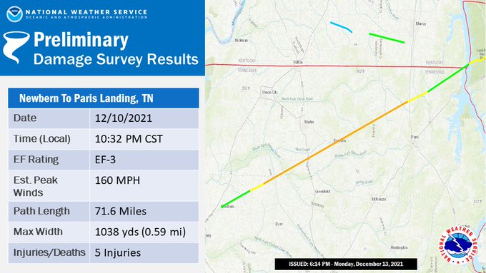
Newbern to Paris Landing, Tennessee tornado
 |
 |
This new supercell produced wind damage in the Osceola and Luxora areas, knocking down numerous power lines and destroying one home. Surveys determined this damage to be straight-line winds. The storm then crossed the Mississippi River and intensified over Dyer County. A tornado developed over Newbern, destroying a gas station and numerous homes and businesses, moving east into Gibson County. Widespread significant damage was observed throughout the community of Kenton with isolated areas of EF-3 damage. This tornado persisted as the storm moved through Weakley County, passing just to the north of Sharon and setting its sights on Dresden. Dresden was hit hard by this tornado with EF-3 damage to numerous homes and businesses across the community. The tornado continued to the east-northeast into Henry County, passing south of Cottage Grove and Puryear, where scattered damage to trees and homes was observed along the path. This storm produced additional damage north of Paris Landing in the Cypress Bay area, crossing Kentucky Lake. This tornado produced winds up to 170 mph along a 72 mile path and was more than one-half mile wide at times.
EF-2 tornado damage in Kenton, TN.
EF-3 tornado damage in Dresden, TN.
Public Information Statement
National Weather Service Memphis TN
408 PM CST Mon Dec 13 2021

...Preliminary NWS Damage Survey for 12/10/21 Tornado Event- West
Tennessee Portion- Update 1...

.OVERVIEW...

A severe thunderstorm produced a long-track tornado that caused
damage from Newbern, TN to Paris Landing, TN and eventually
crossed the Tennessee River.

.Tornado in #1 Newbern to Paris Landing...

Rating: EF-3
Estimated Peak Wind: 160 mph
Path Length /Statute/: 71.6 miles
Path Width /Maximum/: 1038 yards
Fatalities: 0
Injuries: 5

Start Date: Dec 10 2021
Start Time: 1032 PM CST
Start Location: SW Newbern
Start Lat/Lon: 36.12 / -89.26

End Date: Dec 10 2021
End Time: 1148 PM CST
End Location: Paris Landing
End Lat/Lon: 36.50 / -88.07

SURVEY SUMMARY:

The first observed damage was a few miles southwest of Newbern,
TN near Washington Street. The tornado moved northeast, uprooting
and snapping numerous trees along its path. Several homes had
significant roof damage. The tornado initially produced EF-1
damage but while progressing northeast, it continued to strengthen
as it approached Dresden, TN. Several buildings and homes in
downtown Dresden suffered significant damage or were completely
destroyed. The tornado slightly weakened and moved northeast
toward Paris Landing and eventually crossed the Tennessee River
into Stewart County in Middle Tennessee.


&&


EF Scale: The Enhanced Fujita Scale classifies tornadoes into the
following categories:

EF0...Weak......65 to 85 mph
EF1...Weak......86 to 110 mph
EF2...Strong. ..111 to 135 mph
EF3...Strong....136 to 165 mph
EF4...Violent...166 to 200 mph
EF5...Violent...> 200 mph

NOTE: Information in this statement is preliminary and subject to
change pending final review of the event and publication in NWS
Storm Data.

$$

SB/MW
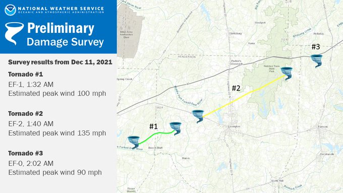
Tornadoes in Madison, Henderson, and Decatur Counties in Tennessee
 |
 |
The storms became more organized into a quasi-linear convective system (QLCS) as they approached the Jackson area. No damage was reported in Jackson, but another mesovortex developed south of town, eventually resulting in a tornado near Beech Bluff. This tornado tracked into far western Henderson County, causing EF-1 damage to several homes and numerous trees. This tornado lifted, but another touched down west of Beech Lake. This tornado tracked across the Lake, producing significant damage (EF-3) north of Lexington in the area around the Timberlake Industrial Complex. A couple of TVA towers were destroyed, knocking out commercial power to much of northeast Henderson County, portions of Hardin County, and virtually all of Decatur County for nearly a week. A third tornado developed in northern Decatur County, moving largely over rural areas before ending in southern Benton County. One home sustained damage and numerous trees were uprooted or damaged.
...NWS Damage Survey For 12/11/21 Madison..Henderson..and Decatur
County Tornadoes...

.Tornado in Eastern Madison and Western Henderson Counties...

Rating: EF-1
Estimated Peak Wind: 100 mph
Path Length /Statute/: 7.2 miles
Path Width /Maximum/: 300 yds
Fatalities: 0
Injuries: 0

Start Date: 12/11/21
Start Time: 132 AM CST
Start Location: 9 miles ESE Jackson, TN
Start Lat/Lon: 35.61/-88.67

End Date: 12/11/21
End Time: 140 AM CST
End Location: 8 miles WSW Lexington, TN
End Lat/Lon: 35.65/-88.55

SURVEY SUMMARY:

The tornado began on Beech Bluff Road near Ranger Road where a
tree was uprooted and a metal outbuilding was damaged. The tornado
then moved ENE where a home sustained significant roof damage
near the intersection of Beech Bluff Road and Willoughby Road. It
then moved northeast where a couple of homes sustained roof and
siding damage near the intersection of Fowler and Old Jackson-Lexington
Road. The tornado then moved northeast where an outbuilding and a
small building were destroyed and came to an end near Luray and
Huron Roads.

.Natchez Trace Tornado in Henderson County...

Rating: EF-2
Estimated Peak Wind: 135 mph
Path Length /Statute/: 15.5 Miles
Path Width /Maximum/: 600 yds
Fatalities: 0
Injuries: 0

Start Date: 12/11/21
Start Time: 140 AM CST
Start Location: 5 miles WNW Lexington, TN
Start Lat/Lon: 35.68/-88.48

End Date: 12/11/21
End Time: 158 AM CST
End Location: 12 miles NE Lexington, TN
End Lat/Lon: 35.77/-88.23

SURVEY SUMMARY:

The tornado began just southwest of US-412 off Pine Crest Drive
where several trees were damaged. The tornado crossed US-412 and
destroyed an outbuilding then moved northeast towards Highway 104
and damaged the roof of a home. It continued to move northeast
across northern Beech Lake and produced more damage in the
Timberlake community. A couple of metal power poles were bent and
a couple of metal buildings were significantly damaged or
destroyed in an industrial park. The most significant damage
occurred just east of this area where two TVA transmission towers
were completely destroyed. The tornado then continued traveling
northeast into Natchez Trace State Park snapping and de-barking
numerous trees along its path.

.Tornado in Decatur County...

Rating: EF-1
Estimated Peak Wind: 90 mph
Path Length /Statute/: 50yards
Path Width /Maximum/: 30 yards
Fatalities: 0 Injuries: 0

Start Date: 12/11/21
Start Time: 202 AM CST
Start Location: 4 miles S Holladay
Start Lat/Lon: 35.81/-88.14

End Date: 12/11/21
End Time: 202 AM CST
End Location: 4 miles S Holladay
End Lat/Lon: 35.80/-88.18

SURVEY SUMMARY:

A brief tornado touched down on the corner of Ora Bawcum Lane and
Verlie Inman Road. This tornado snapped several trees at their
base, one of which fell onto and demolished half of a mobile home.
Insulation and debris from the mobile home was lofted and
scattered into a nearby field.

EF Scale: The Enhanced Fujita Scale classifies tornadoes into the
following categories:

EF0...Weak......65 to 85 mph
EF1...Weak......86 to 110 mph
EF2...Strong. ..111 to 135 mph
EF3...Strong....136 to 165 mph
EF4...Violent...166 to 200 mph
EF5...Violent...> 200 mph

NOTE: Information in this statement is preliminary and subject to
change pending final review of the event and publication in NWS
Storm Data.

$$

SMW/CJC/AJC
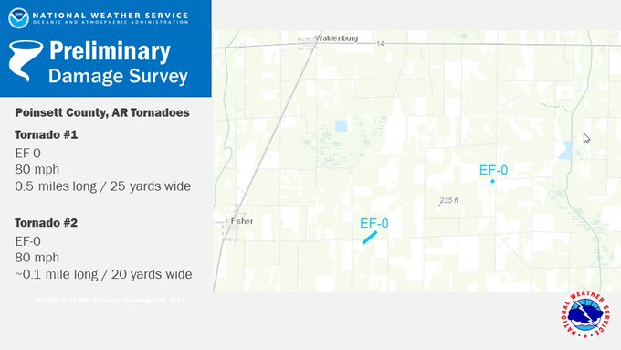
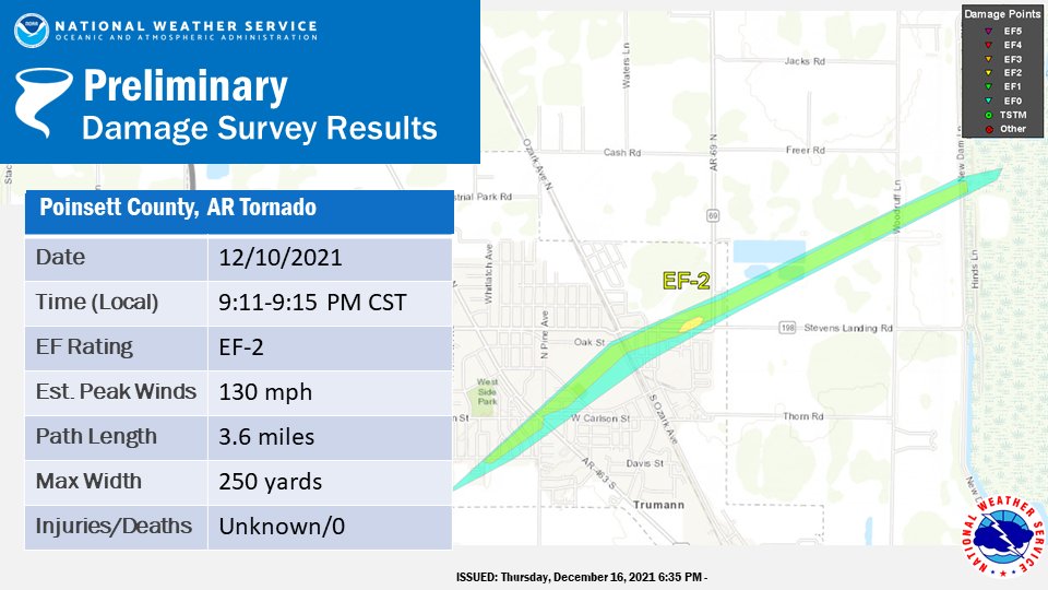
Trumann Tornado in Poinsett County, Arkansas
 |
 |
As the initial supercell was crossing the state line into Kentucky, a string of supercells was moving into eastern Arkansas. A few brief tornadoes produced minor damage near Cash in western Craighead County and in the Fisher area of western Poinsett County. As the dominant supercell moved into eastern Poinsett County, the mesocyclone quickly intensified and the storm produced an EF-2 tornado in Trumann. This tornado resulted in several injuries and produced widespread damage to homes and businesses throughout the community. Fortunately, this supercell weakened on its way into Mississippi County as a new storm began to dominate the area.
Damage on Wayne St in Trumann, AR.
Public Information Statement
National Weather Service Memphis TN
552 PM CST Thu Dec 16 2021
...NWS Damage Survey For 12/10/21 Tornado Event
.OVERVIEW...A thunderstorm produced three tornadoes in Poinsett County
on the evening of Dec. 10, 2021.
.Tornado #1 in Poinsett County near Fisher...
Rating: EF-0
Estimated Peak Wind: 80 mph
Path Length /Statute/: 0.5 miles
Path Width /Maximum/: 25 yards
Fatalities: 0
Injuries: 0
Start Date: Dec 10 2021
Start Time: 845 PM CST
Start Location: 4 miles ESE Fisher / Poinsett County / AR
Start Lat/Lon: 35.4845 / -90.9068
End Date: Dec 10 2021
End Time: 847 PM CST
End Location: 4 miles E Fisher / Poinsett County / AR
End Lat/Lon: 35.4893 / -90.9001
SURVEY SUMMARY: Several outbuildings damaged and some damage to home and
trees. Tornado started and ended in open fields.
.Tornado #2 in Poinsett County near Fisher...
Rating: EF-0
Estimated Peak Wind: 80 mph
Path Length /Statute/: Less than quarter mile
Path Width /Maximum/: 20 yards
Fatalities: 0
Injuries: 0
Start Date: Dec 10 2021
Start Time: 851 PM CST
Start Location: 7 miles ENE Fisher / Poinsett County / AR
Start Lat/Lon: 35.5093 / -90.8431
End Date: Dec 10 2021
End Time: 851 PM CST
End Location: 7 miles ENE Fisher / Poinsett County / AR
End Lat/Lon: 35.5099 / -90.8418
SURVEY SUMMARY: Destroyed an outbuilding.
.Tornado #3 in Poinsett County (Trumann AR)...
Rating: EF-2
Estimated Peak Wind: 130 mph
Path Length /Statute/: 3.6 miles
Path Width /Maximum/: 250 yards
Fatalities: 0
Injuries: Unknown
Start Date: Dec 10 2021
Start Time: 911 PM CST
Start Location: 1.3 SW Trumann / Poinsett County / AR
Start Lat/Lon: 35.6654 / -90.5268
End Date: Dec 10 2021
End Time: 915 PM CST
End Location: 2.3 NE Trumann / Poinsett County / AR
End Lat/Lon: 35.6915 / -90.4719
SURVEY SUMMARY:
Torndao developed just southwest of Trumann and damaged numerous homes,
businesses, and trees. Worst damage in northeast part of Trumann with
business and homes destroyed. Tornado path ended near the St. Francis River.
EF Scale: The Enhanced Fujita Scale classifies tornadoes into the
following categories:
EF0...Weak......65 to 85 mph
EF1...Weak......86 to 110 mph
EF2...Strong. ..111 to 135 mph
EF3...Strong....136 to 165 mph
EF4...Violent...166 to 200 mph
EF5...Violent...> 200 mph
NOTE: Information in this statement is preliminary and subject to
change pending final review of the event and publication in NWS
Storm Data.
We would like to thank the Emergency Management from Poinsett County in
helping with these surveys.
$$
ARS/TLSJr
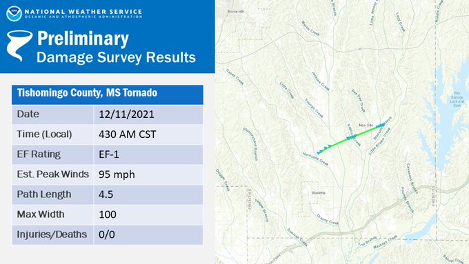
Tornado in Prentiss County, Mississippi
The final significant storm of the event moved north of the Tupelo area, intensifying as it moved into Prentiss County. A tornado touched down in rural areas of the county, damaging a few homes and numerous trees in the New Site area. Some additional wind damage was observed as the storms moved east into Itawamba and southern Tishomingo Counties, but this was mainly to trees.
The severe weather finally moved out of the area by 5 AM, but not before leaving a lasting impact on the lives of many. In total, the Mid-South experienced 18 tornadoes and widespread damage to homes and businesses, upending the lives of numerous Mid-South residents. There were 8 fatalities associated with these storms and an unknown number of injuries.
Public Information Statement
National Weather Service Memphis TN
313 PM CST Thu Dec 16 2021

...NWS Damage Survey For 12/11/21 Tornado Event...

.OVERVIEW...A tornado occurred in Prentiss County, Mississippi,
Saturday, Dec. 11, 2021.

.Tornado in Prentiss County Mississippi...

Rating: EF-1
Estimated Peak Wind: 95 mph
Path Length /Statute/: 4.5 miles
Path Width /Maximum/: 100 yards
Fatalities: 0
Injuries: 0

Start Date: Dec. 11 2021
Start Time: 430 AM CST
Start Location: 2.3 miles N Marietta MS
Start Lat/Lon: 34.5365 / -88.4622

End Date: Dec. 11 2021
End Time: 432 AM CST
End Location: 5.8 miles NE Marietta MS
End Lat/Lon: 34.5610 / -88.3883

SURVEY SUMMARY: NWS meteorologists surveyed storm damage in the area of
Marietta, MS in Prentiss County and determined it was the result of
a tornado. The tornado began in a field along HWY 371 just south of
MS-4 East. As the tornado tracked northeastward, hardwood and softwood
trees were uprooted with a few snapped trunks. The worst damage occurred
along CR 4111, where a site-built home had a large section of roof
blown off and a carport totally destroyed. Nearby damage consisted
of a narrow path of uprooted trees and a few snapped trunks. It is
along this portion of the track that the tornado was given a peak rating
of EF-1. Just down the road, a mobile home had a section of peeled roof.
The tornado then paralleled CR 3401 to the south, with a narrow but
visible path of uprooted trees with some snapped trunks as the circulation
cut across tree lines between fields. The final area of structural damage
was along CR 3461 where a mobile home had a section of roof peeled back.
A few nearby trees were also uprooted just northeast of the home with
dissipation of the tornado apparent shortly thereafter.


EF Scale: The Enhanced Fujita Scale classifies tornadoes into the
following categories:

EF0...Weak......65 to 85 mph
EF1...Weak......86 to 110 mph
EF2...Strong. ..111 to 135 mph
EF3...Strong....136 to 165 mph
EF4...Violent...166 to 200 mph
EF5...Violent...> 200 mph

NOTE: Information in this statement is preliminary and subject to
change pending final review of the event and publication in NWS
Storm Data.

Special thanks to NWS Birmingham for completing this survey and
to Prentiss County Emergency Management for helping with the
survey.

$$

TLSJr
Memphis Metro Storms:
Line of storms, with embedded supercells, produced damaging winds up to 60-70 mph as they moved through the Memphis metro area. As the storms approached the Mississippi River, a mesovortex developed over West Memphis. This mesovortex moved northeast across southern Marion, derailing more than 20 railroad cars. Another mesovortex formed over south Memphis. As this mesovortex moved northeast, damaging winds began knocking down large trees, several on homes. A fatality resulted in Orange Mound when a tree fell on a home. As the storms moved east into Fayette County, a brief tornado was observed near Somerville. Fortunately, no damage was reported from this tornado
Local Storm Reports:
PRELIMINARY LOCAL STORM REPORT...SUMMARY
NATIONAL WEATHER SERVICE MEMPHIS TN
158 AM CST MON DEC 20 2021
..TIME... ...EVENT... ...CITY LOCATION... ...LAT.LON...
..DATE... ....MAG.... ..COUNTY LOCATION..ST.. ...SOURCE....
..REMARKS..
0644 PM TORNADO 3 NNE WEINER 35.66N 90.88W
12/10/2021 POINSETT AR TRAINED SPOTTER
TREES DOWN ACROSS THE HIGHWAY. CONE TORNADO PASSED JUST
NORTH OF WEINER.
0700 PM TSTM WND DMG 3 NNE GREENFIELD 35.73N 90.69W
12/10/2021 CRAIGHEAD AR SOCIAL MEDIA
POWER POLES WERE SNAPPED ALONG HWY 1 AND A LARGE RICE
FACILITY SUSTAINED DAMAGE.
0700 PM TORNADO 5 S JONESBORO 35.75N 90.69W
12/10/2021 CRAIGHEAD AR SOCIAL MEDIA
TREES SNAPPED IN HALF AND DAMAGE TO SHED.
0708 PM TORNADO 4 NNW BAY 35.79N 90.59W
12/10/2021 CRAIGHEAD AR LAW ENFORCEMENT
TORNADO REPORTED BY LAW ENFORCEMENT.
0724 PM TORNADO NW MONETTE 35.89N 90.34W
12/10/2021 CRAIGHEAD AR LAW ENFORCEMENT
TORNADO REPORTED BY LAW ENFORCEMENT.
0732 PM TORNADO 2 N LEACHVILLE 35.95N 90.26W
12/10/2021 MISSISSIPPI AR LAW ENFORCEMENT
TORNADO REPORTED BY LAW ENFORCEMENT.
0741 PM TSTM WND DMG 3 SSW HORNERSVILLE 36.00N 90.13W
12/10/2021 DUNKLIN MO TRAINED SPOTTER
SIGNIFICANT DAMAGE TO HOME AND TREES ALONG STATE LINE
ROAD. SEVERAL VEHICLES AND A BOAT WERE TOSSED OVER
OVERTURNED. LIKELY DUE TO TORNADO.
0741 PM TSTM WND DMG 4 SW HORNERSVILLE 35.99N 90.16W
12/10/2021 MISSISSIPPI AR TRAINED SPOTTER
SIGNIFICANT DAMAGE TO A LARGE BARN ON HWY 119 JUST
SOUTH OF THE MISSOURI STATE LINE.
0742 PM TORNADO 2 SSW HORNERSVILLE 36.01N 90.13W
12/10/2021 DUNKLIN MO LAW ENFORCEMENT
TORNADO REPORTED BY LAW ENFORCEMENT.
0742 PM TORNADO 1 S HORNERSVILLE 36.03N 90.11W
12/10/2021 DUNKLIN MO TRAINED SPOTTER
NUMEROUS DAMAGE ON COUNTY ROAD 655.
0754 PM TSTM WND DMG 5 W DENTON 36.09N 89.97W
12/10/2021 DUNKLIN MO TRAINED SPOTTER
A HIGH TENSION POWER LINE TOWER WAS SEVERELY DAMAGED
NEAR HWY NN AND HWY 164. THERE WERE ALSO SEVERAL CENTER
PIVOT IRRIGATION SYSTEMS OVERTURNED. LIKELY DUE TO
TORNADO.
0805 PM TORNADO 2 SE DEERING 36.18N 89.86W
12/10/2021 PEMISCOT MO EMERGENCY MNGR
LARGE TORNADO REPORTED ON THE GROUND SOUTHEAST OF
DEERING.
0830 PM TORNADO 1 W CASH 35.80N 90.95W
12/10/2021 CRAIGHEAD AR LAW ENFORCEMENT
BRIEF TORNADO TOUCHDOWN NEAR CASH.
0835 PM TORNADO 3 SE TIPTONVILLE 36.35N 89.42W
12/10/2021 LAKE TN BROADCAST MEDIA
*** 2 FATAL *** SIGNIFICANT DAMAGE TO CYPRESS POINT
RESORT AND LAKEVIEW RESTAURANT ON REELFOOT LAKE.
0838 PM TORNADO SAMBURG 36.38N 89.35W
12/10/2021 OBION TN LAW ENFORCEMENT
SAMBURG FIRE STATION TOOK DIRECT HIT WITH PEOPLE
TRAPPED IN DAMAGE.
0840 PM TSTM WND DMG 6 SW BONO 35.85N 90.87W
12/10/2021 CRAIGHEAD AR SOCIAL MEDIA
NUMEROUS LIMBS DOWN IN THE BONO AREA. UTILITY POLES
SNAPPED 6 MILES SOUTHWEST OF TOWN. POSSIBLE TORNADO.
0845 PM TORNADO 4 E FISHER 35.48N 90.91W
12/10/2021 POINSETT AR NWS STORM SURVEY
BRIEF EF-0 TORNADO DAMAGED SEVERAL OUTBUILDINGS, TREES,
AND ONE HOME.
0851 PM TORNADO 6 SE WALDENBURG 35.51N 90.84W
12/10/2021 POINSETT AR NWS STORM SURVEY
VERY BRIEF EF-0 TORNADO THAT DAMAGED ONE OUTBUILDING.
0915 PM TORNADO TRUMANN 35.67N 90.52W
12/10/2021 POINSETT AR TRAINED SPOTTER
MULTIPLE BUILDINGS DAMAGED IN TRUMANN.
0930 PM TSTM WND DMG HICKORY RIDGE 35.40N 90.99W
12/10/2021 CROSS AR SOCIAL MEDIA
NUMEROUS TREE BRANCHES DOWN ACROSS THE COMMUNITY.
0953 PM TORNADO 3 NE KEISER 35.71N 90.05W
12/10/2021 MISSISSIPPI AR NEWSPAPER
A HOME WAS DESTROYED ON COTTONWOOD CORNER ROAD JUST
WEST OF OSCEOLA.
0955 PM TSTM WND DMG NE OSCEOLA 35.70N 89.99W
12/10/2021 MISSISSIPPI AR NEWSPAPER
SEVEREAL POWER LINES WERE KNOCKED DOWN IN OSCEOLA.
TRUCKS WERE TURNED WEST OF THE TOWN AND A TRUCK WAS
BLOWN OFF OF I-55.
1000 PM TSTM WND DMG LUXORA 35.76N 89.93W
12/10/2021 MISSISSIPPI AR NEWSPAPER
POWER LINES WERE DOWN IN LUXORA.
1037 PM TORNADO 4 ENE NEWBERN 36.14N 89.21W
12/10/2021 DYER TN NWS EMPLOYEE
TORNADIC DEBRIS SIGNATURE NOTED NORTHEAST OF NEWBERN.
1044 PM TSTM WND DMG KENTON 36.20N 89.01W
12/10/2021 GIBSON TN EMERGENCY MNGR
EM REPORTED DAMAGE TO 25-30 HOMES. ON THE GIBSON SIDE
OF KENTON.
1045 PM NON-TSTM WND DMG 3 S OLIVE BRANCH 34.91N 89.83W
12/10/2021 DESOTO MS EMERGENCY MNGR
TREE ACROSS ROAD NEAR HWY 305 AND BYHALIA ROAD
1047 PM TORNADO KENTON 36.20N 89.01W
12/10/2021 GIBSON TN AMATEUR RADIO
MULTIPLE HOUSES DESTROYED IN KENTON.
1047 PM TORNADO KENTON 36.20N 89.01W
12/10/2021 GIBSON TN AMATEUR RADIO
REPORT OF MULTIPLE POWER LINES DOWN, TREES DOWN, AND
IMPASSABLE ROADS.
1055 PM HAIL 4 N DYER 36.13N 88.99W
12/10/2021 E1.00 INCH GIBSON TN TRAINED SPOTTER
QUARTER SIZED HAIL NEAR DYER, TENNESSEE, WITH ABOUT
30-40 MPH WINDS.
1108 PM TORNADO DRESDEN 36.28N 88.69W
12/10/2021 WEAKLEY TN EMERGENCY MNGR
*** 1 INJ *** TORNADO WITH AT LEAST 1 PERSON INJURED IN
DRESDEN WITH 6 BUILDINGS DAMAGED.
1122 PM TORNADO 2 E COTTAGE GROVE 36.38N 88.44W
12/10/2021 HENRY TN 911 CALL CENTER
WIDESPREAD DAMAGE TO HOMES, TREES, AND POWER LINES
ALONG LAMPKINS RD NEAR COTTAGE GROVE.
1135 PM TSTM WND DMG PURYEAR 36.44N 88.33W
12/10/2021 HENRY TN 911 CALL CENTER
HOUSE TRAILER ROLLED OVER ON SHADY GROVE ROAD. NUMEROUS
OTHER REPORTS OF DAMAGE IN THE PURYEAR AREA. LIKELY DUE
TO TORNADO.
1145 PM TORNADO 8 ENE BUCHANAN 36.48N 88.08W
12/10/2021 HENRY TN SOCIAL MEDIA
WIDESPREAD TREE AND ROOF DAMAGE NORTH OF PARIS LANDING
ALONG CYPRESS ROAD.
1156 PM TSTM WND DMG 3 NE WEST MEMPHIS 35.18N 90.15W
12/10/2021 CRITTENDEN AR EMERGENCY MNGR
MORE THAN 20 TRAIN CARS WERE DERAILED NEAR THE WEST
MEMPHIS-MARION BORDER OFF OF MOUND CITY ROAD.
1201 AM TSTM WND DMG 3 W FRAYSER 35.21N 90.02W
12/11/2021 SHELBY TN EMERGENCY MNGR
TREE DOWN ACROSS ATLA VISTA AVENUE.
1205 AM TSTM WND DMG 2 SE MIDTOWN MEMPHIS 35.11N 89.96W
12/11/2021 SHELBY TN EMERGENCY MNGR
TREE DOWN ON HOME ON SPOTTSWOOD AVE
1207 AM TSTM WND DMG 2 ESE MIDTOWN MEMPHIS 35.13N 89.95W
12/11/2021 SHELBY TN EMERGENCY MNGR
TREE DOWN ON HOUSE ON S. GREER ST.
1208 AM TSTM WND DMG 2 SSE MIDTOWN MEMPHIS 35.11N 89.97W
12/11/2021 SHELBY TN EMERGENCY MNGR
*** 1 FATAL *** TREE BLOWN DOWN ONTO HOUSE
1209 AM TSTM WND DMG 3 SSE MIDTOWN MEMPHIS 35.10N 89.97W
12/11/2021 SHELBY TN EMERGENCY MNGR
COLLAPSED ROOF ON STRUCTURE ON LOWELL AVE.
1217 AM TSTM WND DMG 1 SE ELLENDALE 35.23N 89.82W
12/11/2021 SHELBY TN PUBLIC
A TREE FELL ON A HOME ON BROADWAY, CAUSING SIGNIFICANT
DAMAGE TO STRUCTURE.
1226 AM HAIL 2 NNE EAST MEMPHIS 35.16N 89.86W
12/11/2021 E0.88 INCH SHELBY TN STORM CHASER
1231 AM TSTM WND DMG 4 SSE SOUTHEAST MEMPHIS 35.02N 89.85W
12/11/2021 SHELBY TN EMERGENCY MNGR
TREE ON HOUSE ON E. SHELBY DRIVE,
1240 AM TORNADO 6 NNE OAKLAND 35.31N 89.46W
12/11/2021 FAYETTE TN SOCIAL MEDIA
PHOTO EVIDENCE OF A BRIEF TORNADO NORTHWEST OF
SOMERVILLE.
1250 AM TSTM WND DMG 2 WNW COLLIERVILLE 35.07N 89.71W
12/11/2021 SHELBY TN NWS EMPLOYEE
TREE AND UTILITY POLE DOWN ON FRANK RD NEAR HOUSTON
LEVEE ROAD.
0100 AM TSTM WND DMG 2 SE MIDTOWN MEMPHIS 35.11N 89.95W
12/11/2021 SHELBY TN BROADCAST MEDIA
TREE DOWN ON CAR ON GREER ST IN ORANGE MOUND.
0115 AM TSTM WND DMG 3 SE SOUTHEAST MEMPHIS 35.03N 89.85W
12/11/2021 SHELBY TN EMERGENCY MNGR
UTILITY POLE DOWN ON CASTLE HEIGHTS DR.
0118 AM TSTM WND DMG OLIVE BRANCH 34.95N 89.83W
12/11/2021 DESOTO MS BROADCAST MEDIA
LARGE TREE DOWN IN OLIVE BRANCH.
0120 AM TSTM WND DMG 5 SE FAIRVIEW 35.71N 88.79W
12/11/2021 MADISON TN PUBLIC
TREE DOWN ON FENCE IN OAKFIELD, AS WELL AS SIDING BLOWN
OFF OF PARTS OF THE HOUSE.
0132 AM TORNADO 2 WNW BEECH BLUFF 35.61N 88.67W
12/11/2021 MADISON TN NWS STORM SURVEY
EF-1 TORNADO BEGAN NEAR BEECH BLUFF AND RANGER ROADS IN
EASTERN MADISON COUNTY AND ENDED NEAR LURAY AND HURON
ROADS IN WESTERN HENDERSON COUNTY. PATH LENGTH WAS 7.2
MILES.
0135 AM TSTM WND DMG 2 N BEECH BLUFF 35.62N 88.63W
12/11/2021 MADISON TN BROADCAST MEDIA
NUMEROUS TREES AND POWER LINES DOWN ON FOWLER ROAD. CAR
WINDOWS BLOWN OUT. POSSIBLE TORNADO.
0137 AM TSTM WND DMG 3 NNE BEECH BLUFF 35.64N 88.60W
12/11/2021 HENDERSON TN SOCIAL MEDIA
ROOF DAMAGE TO HOMES AND BARNS. POWERLINES AND TREES
DOWN. POSSIBLE TORNADO.
0140 AM TORNADO 4 SSE BARGERTON 35.68N 88.48W
12/11/2021 HENDERSON TN NWS STORM SURVEY
EF-2 TORNADO WITH A 15.5 MILE PATH LENGTH. THIS TORNADO
CAUSED THE MOST SIGNIFICANT DAMAGE NORTH OF LEXINGTON
NEAR THE TIMBERLAKE INDUSTRIAL PARK AND CRUMPLED TWO TVA
HIGH-TENSION ELECTRIC TOWERS.
0145 AM TSTM WND DMG 3 W LEXINGTON 35.65N 88.45W
12/11/2021 HENDERSON TN EMERGENCY MNGR
WIDESPREAD DAMAGE TO TREES AND POWERLINES ALONG HIGHWAY
412 JUST WEST OF LEXINGTON.
0145 AM TSTM WND DMG 4 N LEXINGTON 35.71N 88.38W
12/11/2021 HENDERSON TN EMERGENCY MNGR
SIGNIFICANT STRUCTURAL DAMAGE TO HOMES AND MOBILE HOMES
NEAR THE TIMBERLAKE INDUSTRIAL PARK. TREES WERE
UPROOTED.
0148 AM TSTM WND DMG 4 S WILDERSVILLE 35.72N 88.37W
12/11/2021 HENDERSON TN EMERGENCY MNGR
TWO TVA HIGH-TENSION POWER LINE TOWERS WERE CRUMPLED
JUST EAST OF THE TIMBERLAKE INDUSTRIAL PARK. THE LOSS OF
THESE LINES HAS RESULTED IN MAJOR UTILITY POWER OUTAGES
INCLUDED NORTHERN HENDERSON, PORTIONS OF HARDIN COUNTY,
AND ESSENTIALLY ALL OF DECATUR COUNTY. THERE WERE ALSO
NUMEROUS DOWN TREES AND SIGNIFICANT ROOF DAMAGE TO A FEW
HOMES.
0202 AM TORNADO 4 S HOLLADAY 35.81N 88.14W
12/11/2021 DECATUR TN NWS STORM SURVEY
A BRIEF EF-0 TORNADO FORMED NEAR ORA BAWCUM LANE AND
VERLIE INMAN ROAD, DAMAGING A MOBILE HOME AND CAUSING
SIGNIFICANT TREE DAMAGE.
0210 AM TSTM WND GST PARSONS 35.65N 88.12W
12/11/2021 E60 MPH DECATUR TN EMERGENCY MNGR
0300 AM FLASH FLOOD 1 ESE DOWNTOWN MEMPHIS 35.13N 90.03W
12/11/2021 SHELBY TN EMERGENCY MNGR
NUMEROUS REPORT OF FLOODING ACROSS DOWNTOWN/MIDTOWN
AREA OF MEMPHIS. REPORTS STARTED AT 1:30 AND CONTINUED.
0426 AM TORNADO 5 NE MARIETTA 34.56N 88.41W
12/11/2021 PRENTISS MS EMERGENCY MNGR
2 MOBILE HOMES DAMAGED AS WELL AS 1 WOOD STRUCTURE NEAR
NEW SITE COMMUNITY.
0431 AM TORNADO 4 NNE MARIETTA 34.55N 88.44W
12/11/2021 PRENTISS MS NWS EMPLOYEE
TORNADIC DEBRIS SIGNATURE NORTHEAST OF MARIETTA.
0500 AM TSTM WND DMG 2 E MANTACHIE 34.32N 88.46W
12/11/2021 ITAWAMBA MS EMERGENCY MNGR
LARGE TREE DOWN ON RIVER RD. NEAR MANTACHIE.
0515 AM TSTM WND DMG BELMONT 34.51N 88.21W
12/11/2021 TISHOMINGO MS LOCAL OFFICIAL
NUMEROUS TREES DOWN ACROSS BELMONT, RESULTING IN
SEVERAL ROAD CLOSURES.
&&
$$


