...APRIL 2013 MONTHLY CLIMATE SUMMARY...
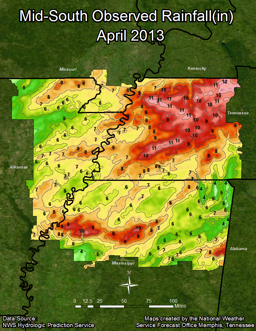
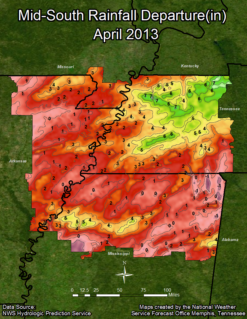
If there are two words that best describe the climate across the Mid-South for April 2013, they are “cool” and “wet”. On average, both Memphis and Jackson were 1.7 degrees cooler this month when compared to the normal average temperature for April, while Jonesboro and Tupelo were 1.6 and 0.9 degrees behind the normal for April, respectively. So far for 2013, the average temperatures for each of the four sites in the summary are around one degree below normal. As for precipitation, it was a rainy month for Memphis, Jackson, and Tupelo, all of which exceeded the normal precipitation for April, while Jonesboro’s total precipitation was just below the normal. Jackson saw the fourth wettest April on record, with 10.60 inches of rainfall. Memphis, Jackson, and Tupelo are all also exceeding the normal for the year so far, while Jonesboro is about fourteen hundredths on an inch of rain behind the normal.
Temperature Data:
Memphis Jackson Jonesboro Tupelo
Average Temperature (APR) : 61.2 58.3 58.3 61.2
Normal Avg. Temp (APR) : 62.9 60.0 59.9 62.1
Departure from Normal (APR) : -1.7 -1.7 -1.6 -0.9
Average Temperature (2013) : 50.0 46.7 46.6 50.1
Normal Avg. Temp (YEAR) : 50.9 47.9 47.3 50.9
Departure from Normal (2013): -0.9 -1.2 -0.7 -0.8
Precipitation Data:
Memphis Jackson Jonesboro Tupelo
Total Snowfall (APR) : 0.00 0.00 0.00 0.00
Total Precipitation (APR) : 6.88 10.60 4.65 5.18
Normal Precipitation (APR) : 5.50 4.86 5.02 4.78
Departure from Normal (APR) : 1.38 5.74 -0.37 0.40
Total Precipitation (2013) : 23.83 26.39 16.53 21.94
Normal Precipitation (YEAR) : 19.03 17.85 16.67 19.04
Departure from Normal (2013) : 4.80 8.54 -0.14 2.90
Significant Weather Events:
April 2013 began with above normal temperatures across the Mid-South as southerly flow prevailed. A potent upper level disturbance and associated cold front developed and moved across the Central Plains during the second week of the month, moving into the Mid-South region on April 10th. While the Mid-South faired pretty well in regards to damage, there were reports of extensive flash flooding, with some areas receiving as much as four inches of rainfall in less than 24 hours. Near the end of April another strong upper level system and associated cold front approached the area.
On April 27th, a surging warm front had dewpoint temperatures in the mid to upper 60’s across the Mid-South. As the cold front began to approach the region during the early evening hours, thunderstorms began to develop and intensify across parts of northwest Mississippi and west Tennessee. Large hail, damaging winds, and tornadoes were reported and confirmed with two separate storm cells. The first storm, which occurred around 9:13 PM, produced an EF1 tornado in Fayette County, Tennessee. This tornado stayed on the ground for about a mile with winds as strong as 105 MPH, causing extensive damage to some farm buildings, as well as being responsible for one reported injury. The second storm occurred in Panola County, Mississippi around 9:55 PM, and produced an EF2 tornado with winds as strong as 112 MPH. This tornado was only on the ground for about three quarters of a mile, but it produced minor structural damage and overturned a flatbed truck and an RV. In addition to the two tornadoes, this same storm system was responsible for flash flooding in some locations in western and middle Tennessee, producing rainfall amounts that exceeded 5-6 inches.
Speaking of tornadoes, the Mid-South only had two recorded during the month of April 2013. However, April is the month with the highest frequency of tornadoes across the region. In fact, from 1873-2011 the Mid-South had 244 tornadoes during the month of April, 53 of which caused fatalities. Of these 244 tornadoes, 16 were classified as violent (tied with the month of March) and 111 were classified as strong, the highest frequency of the entire calendar year. Eighty-three percent of all violent tornadoes in this same time period occurred between March and May.
April 2013 Precipitation Graphics:
ZDM

